Strong cold front will sweep across the area Tuesday.
Potent upper level storm system will move across the plains and into the OH valley early to mid this week allowing a cold air mass to move southward across TX starting Tuesday. Low level warm advection is in progress today with southerly winds pumping moisture back into the region. Main dynamics with this storm system will be northeast of SE TX, so not expecting much in the way of rainfall or severe weather compared to locations just to our east on Tuesday. Could see a line of showers with the front. Main news will be the strong post frontal winds of 20-30mph on Tuesday as cold air moves into the region from the north. Temperatures Tuesday morning in the lower 60’s will fall into the 40’s by late afternoon under strong cold air advection.
Will go ahead and lower both highs and lows for both Christmas Eve and Christmas Day as upstream air mass is slightly colder than projected yesterday. Some locations could be close to freezing Christmas morning and while southerly winds will return during the day, the warm up will be tempered by the cold start so instead of near 70 probably lower 60’s for highs. Skies will be sunny both Christmas Eve and Christmas Day.
Long Range:
Problems and a lot of them in the extended as models continue to attempt to grasp a potential arctic air intrusion into the US in the days before New Year’s. There has actually been very little change in the upper air pattern features of a ridge building into Alaska and a large and deep downstream trough carving out over much of the US. The upper air pattern would suggest arctic air is delivered into the US via Montana and North Dakota around the 28-29th and then pours southward down the spine of the Rockies and into TX by the 31st. Surface pressures on the order of 1050mb or greater over Montana toward the end of December is certainly noteworthy.
While the source region of NW Canada is not exceptionally cold at the moment the setup in the flow aloft would appear to bring the currently bitter cold northern Russian air mass into NW Canada by early to mid next week and then deliver it southward into the US during the mid to late part of next week.
Of other interest continues to be the threat for a fairly strong storm system to move across TX with a potentially cold arctic air mass in place. This raises all kinds of P-type concerns from the 31st into the 2nd across much of the state including SE TX. The amount of cold air that moves southward will likely determine the overall outcome with respect to P-type during this period along with any potential for accumulations. Needless to say… the mid to late week period next week will be the main forecast focus over the next several days.
Texas Winter 2014-2015
Moderator: S2k Moderators
Forum rules
 The posts in this forum are NOT official forecast and should not be used as such. They are just the opinion of the poster and may or may not be backed by sound meteorological data. They are NOT endorsed by any professional institution or STORM2K.

The posts in this forum are NOT official forecast and should not be used as such. They are just the opinion of the poster and may or may not be backed by sound meteorological data. They are NOT endorsed by any professional institution or STORM2K.
-
gboudx

- S2K Supporter

- Posts: 4047
- Joined: Thu Sep 04, 2003 1:39 pm
- Location: Rockwall, Tx but from Harvey, La
jeff's update for next week's cold:
0 likes
-
TeamPlayersBlue

- Category 5

- Posts: 3308
- Joined: Tue Feb 02, 2010 1:44 am
- Location: Denver/Applewood, CO
I cant see all the data from the Euro, but the 850 line is well into the GOM. You think the Euro has an issue with moisture?
0 likes
Personal Forecast Disclaimer:
The posts in this forum are NOT official forecast and should not be used as such. They are just the opinion of the poster and may or may not be backed by sound meteorological data. They are NOT endorsed by any professional institution or storm2k.org. For official information, please refer to the NHC and NWS products.
The posts in this forum are NOT official forecast and should not be used as such. They are just the opinion of the poster and may or may not be backed by sound meteorological data. They are NOT endorsed by any professional institution or storm2k.org. For official information, please refer to the NHC and NWS products.
-
SouthernMet

- Category 3

- Posts: 857
- Joined: Sun Aug 29, 2010 8:23 pm
- Location: fort worth, tx
Re: Texas Winter 2014-2015
Latest sref still very bullish.  #dynamiccooling
18z nam comes in colder.
18z nam comes in colder.
Last edited by SouthernMet on Mon Dec 22, 2014 3:16 pm, edited 1 time in total.
0 likes
Nothing that SouthernMet posts, is an official forecast,nor does it reflect views of STORM2K.. SouthernMet is just adding to the great discussions on STORM2K.. Refer to NWS for official forecasts.
-
Ralph's Weather
- S2K Supporter
- Posts: 2968
- Age: 36
- Joined: Fri Dec 13, 2013 11:55 am
- Location: Lindale, TX
Re: Texas Winter 2014-2015
SouthernMet wrote:Latest sref still very bullish.
I am liking the trend. Tomorrow could be a cold one with rain changing to snow north of I-20. If it doesn't quite make the change it will sure be a cold, blustery and wet day nonetheless. This is just the preview for what could be a snowy week next week.
0 likes
Follow on Facebook at Ralph's Weather.
-
ThunderSleetDreams

- S2K Supporter
- Posts: 1398
- Age: 41
- Joined: Tue Dec 20, 2011 4:42 pm
- Location: S of Weimar, TX
Re: Texas Winter 2014-2015
Can someone explain to me why it is that the 6z runs lose the cold most days and the other 3 runs keep it in the forecast. Does 6z lack something?
0 likes
#NeverSummer
I hibernate when it gets above 75 degrees!
I hibernate when it gets above 75 degrees!
-
Ralph's Weather
- S2K Supporter
- Posts: 2968
- Age: 36
- Joined: Fri Dec 13, 2013 11:55 am
- Location: Lindale, TX
Re: Texas Winter 2014-2015
ThunderSleetDreams wrote:Can someone explain to me why it is that the 6z runs lose the cold most days and the other 3 runs keep it in the forecast. Does 6z lack something?
If I recall correctly the 06Z and 18Z runs do not include the upper air input as that is collected only twice a day in most cases.
0 likes
Follow on Facebook at Ralph's Weather.
-
GRAYSONCO.WX
- Category 1

- Posts: 450
- Joined: Thu Jan 06, 2011 4:29 pm
- Location: Denison, Texas
Re: Texas Winter 2014-2015
SouthernMet wrote:Latest sref still very bullish.
18z nam comes in colder.
The 18Z NAM (4km on WeatherBELL) is showing snow accumulations across north Texas; some 2-4" amounts near the Metro--especially just south. LOL! Interesting for sure.
0 likes
-
Ralph's Weather
- S2K Supporter
- Posts: 2968
- Age: 36
- Joined: Fri Dec 13, 2013 11:55 am
- Location: Lindale, TX
Re: Texas Winter 2014-2015
GRAYSONCO.WX wrote:SouthernMet wrote:Latest sref still very bullish.
18z nam comes in colder.
The 18Z NAM (4km on WeatherBELL) is showing snow accumulations across north Texas; some 2-4" amounts near the Metro--especially just south. LOL! Interesting for sure.
I think it is more of a snow algorithm issue as the models are not really showing any way for the snow to not melt unless they think it will come down so hard that it will survive 5,000 feet of above freezing temps. That is if temps that high are cold enough which the models are not consistent on. I wish it would snow as I love to see huge forecast busts especially when I saw the possibility way out, but I am not seeing it this time around.
0 likes
Follow on Facebook at Ralph's Weather.
-
GRAYSONCO.WX
- Category 1
- Posts: 450
- Joined: Thu Jan 06, 2011 4:29 pm
- Location: Denison, Texas
Re: Texas Winter 2014-2015
Jarodm12 wrote:Why am I not seeing this on twisterdata or instantweathermaps?
Not too sure? Maybe a slightly different algorithm? I know the NAM on TwisterData is not as high of a resolution as the 4km NAM on WeatherBELL, so it can't display the small impacts from small convection that may briefly change rain to rain/snow because of cooling, which is likely what the 4km NAM is picking up on.
0 likes
Re: Texas Winter 2014-2015
wxman57 wrote:Well, EC has 1.5" snow for Houston on New Year's Eve, which I think is unlikely as the EC's snow algorithm has been off for coastal TX for a while. GFS has a long period of freezing rain/sleet from 12Z/31 to 12Z/1, which would be more likely. Low in the Gulf would mean widespread precip, assuming models are correct this far out. I don't see any signs of extreme cold, though. Of course, we don't get freezing/frozen precip if the air is too cold/dry.
I'll take the winter weather chances in SE TX over extreme cold any time. I can't stand it when we're stuck in the 30s with cold rain. The Euro does suggest the cold will be deep enough on the 12z run. Have to watch and see if we get consistency in that model with the amount/depth of the cold in TX.
Last edited by ronyan on Mon Dec 22, 2014 3:55 pm, edited 2 times in total.
0 likes
-
Rgv20

- S2K Supporter
- Posts: 2456
- Age: 37
- Joined: Wed Jan 05, 2011 5:42 pm
- Location: Edinburg/McAllen Tx
Let it be windy, windy!
Special Weather Statement
SPECIAL WEATHER STATEMENT
NATIONAL WEATHER SERVICE BROWNSVILLE TX
156 PM CST MON DEC 22 2014
TXZ248>257-230400-
ZAPATA-JIM HOGG-BROOKS-KENEDY-STARR-HIDALGO-INLAND WILLACY-
INLAND CAMERON-COASTAL WILLACY-COASTAL CAMERON-
INCLUDING THE CITIES OF...ZAPATA...HEBBRONVILLE...FALFURRIAS...
SARITA...RIO GRANDE CITY...ROMA...MCALLEN...EDINBURG...PHARR...
MISSION...WESLACO...RAYMONDVILLE...BROWNSVILLE...HARLINGEN...
PORT MANSFIELD...PORT ISABEL...SOUTH PADRE ISLAND...
LAGUNA HEIGHTS...LAGUNA VISTA
156 PM CST MON DEC 22 2014
...COLD FRONT TO USHER IN STRONG AND GUSTY WINDS TUESDAY...
THE STRONGEST FRONT OF DECEMBER SURGES THROUGH DEEP SOUTH TEXAS
AND THE RIO GRANDE VALLEY TUESDAY MORNING. MAIN IMPACT WITH THIS
FRONT WILL BE DEVELOPING STRONG AND GUSTY NORTHWEST WINDS. AS THE
FRONT PASSES BETWEEN 9 AM AND NOON...NORTHWEST WINDS INCREASE
BETWEEN 20 TO 25 MPH WITH HIGHER GUSTS. A STRONG JET STREAM IN THE
MID LAYERS OF THE ATMOSPHERE MOVES RAPIDLY SOUTHEAST TRAVERSING
DEEP SOUTH TEXAS IN THE LATTER HALF OF THE AFTERNOON AND INTO
TUESDAY EVENING. WINDS ARE ANTICIPATED TO BECOME STRONGER AS THIS
WIND MAXIMUM MOVES OVERHEAD WITH AN INCREASE TO 25 TO 35 MPH AND
GUSTS OF 45-50 MPH ANTICIPATED THROUGH THE EARLY EVENING HOURS.
SUSTAINED WINDS DIMINISH A FEW HOURS AFTER SUNSET HOWEVER GUSTY
PERIODS OF 30 TO 40 MPH ARE STILL EXPECTED TO PERSIST MUCH OF THE
OVERNIGHT PERIOD. THERE IS HIGH CONFIDENCE OF A WIND ADVISORY
BEING ISSUED WITH LOWER CONFIDENCE OF A FEW HOURS OF HIGH WIND
GUSTS OF 50 MPH OR GREATER. CHRISTMAS HOLIDAY DECORATIONS WILL BE
BLOWN AROUND AND POSSIBLY DAMAGED DUE TO THE STRONG GUSTY WINDS.
RESIDENTS MAY WANT TO SECURE LOSE OBJECTS LAWN FURNITURE AND TRASH
CAN AS WELL AS TIE DOWN ANY DECORATIONS THAT MAY THE TENDENCY TO
LOSE SUPPORT.
FOR MARINE INTEREST A GALE WATCH IS IN EFFECT FOR TUESDAY MORNING
THROUGH TUESDAY NIGHT. NORTHWEST WINDS TO QUICKLY INCREASE AS THE
FRONT PUSHES OFFSHORE BETWEEN 9 AND NOON. SUSTAINED WINDS TO
APPROACH 34 KNOTS WITH GUSTS AS HIGH AS 45 KNOTS POSSIBLE TUESDAY
AFTERNOON AND EVENING. ANY VESSELS NOT SECURED TO THEIR MOORINGS
COULD BE DAMAGED AS BAY WATERS BECOME VERY ROUGH TUESDAY
AFTERNOON. HAZARDOUS SEAS OFFSHORE TO DEVELOP STEADILY BUILDING
TO 10 FEET OR GREATER BY SUNSET AND NEAR 14 FEET OVERNIGHT. STRONG
OFFSHORE FLOW TO PERSIST INTO WEDNESDAY WITH SMALL CRAFT ADVISORY
CONDITIONS LIKELY TO FOLLOW ANY GALE WARNINGS THAT ARE ISSUED.
$$
0 likes
The following post is NOT an official forecast and should not be used as such. It is just the opinion of the poster and may or may not be backed by sound meteorological data. It is NOT endorsed by any professional institution including storm2k.org For Official Information please refer to the NHC and NWS products.
-
Ralph's Weather
- S2K Supporter
- Posts: 2968
- Age: 36
- Joined: Fri Dec 13, 2013 11:55 am
- Location: Lindale, TX
Re: Texas Winter 2014-2015
GRAYSONCO.WX wrote:Jarodm12 wrote:Why am I not seeing this on twisterdata or instantweathermaps?
Not too sure? Maybe a slightly different algorithm? I know the NAM on TwisterData is not as high of a resolution as the 4km NAM on WeatherBELL, so it can't display the small impacts from small convection that may briefly change rain to rain/snow because of cooling, which is likely what the 4km NAM is picking up on.
Yep, the only way to overcome these warm surface temps and dewpoints is convection which the 4km NAM seems to show. We will see how that plays out, but it seems like a hard task.
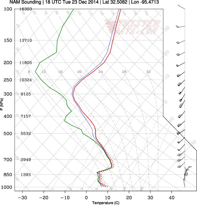
Here is Dallas at 9am tomorrow according to the 18Z NAM:
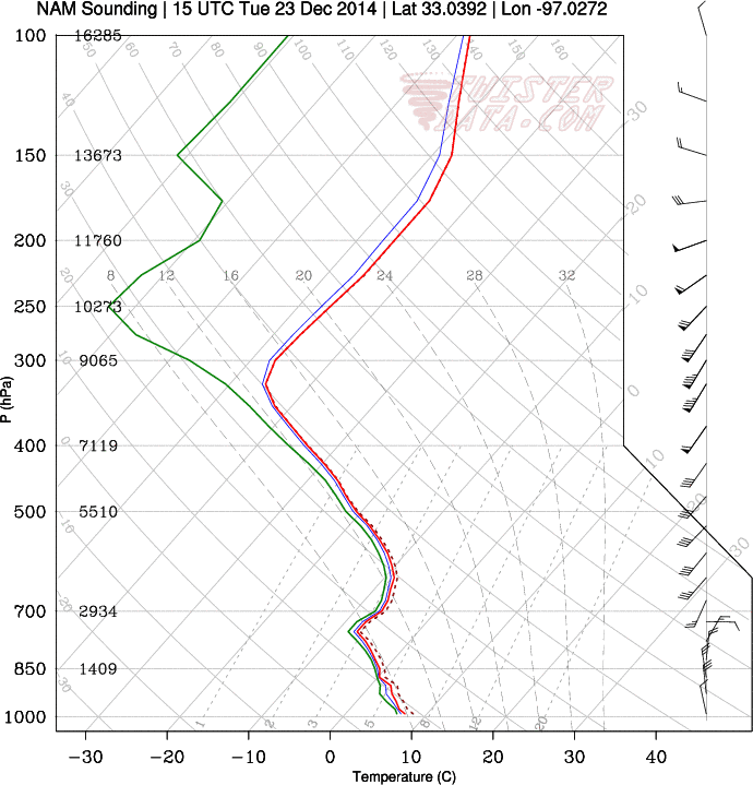
And my location in Lindale at noon:
0 likes
Follow on Facebook at Ralph's Weather.
-
orangeblood
- S2K Supporter
- Posts: 3334
- Joined: Tue Dec 15, 2009 6:14 pm
- Location: Fort Worth, TX
Re: Texas Winter 2014-2015
Latest 4KM WRF model suggests only rain accumulating across North Texas, nothing frozen...would find it really surprising if this system over came the warm air at the surface to produce anything significant....currently sitting at 65 F at DFW
0 likes
-
wxman57

- Moderator-Pro Met

- Posts: 22482
- Age: 66
- Joined: Sat Jun 21, 2003 8:06 pm
- Location: Houston, TX (southwest)
Re: Texas Winter 2014-2015
Jarodm12 wrote:Why am I not seeing this on twisterdata or instantweathermaps?
Each website may decode the data differently, using different parameters to indicate snow. Some parameters that work up north may not work in the south. I think WxBell's setup is too liberal with snow down south, Twisterdata's is not. Levi's TropicalTidbits also indicates rain with the 18Z NAM. That seems most likely:

0 likes

Re: Texas Winter 2014-2015
orangeblood wrote:Latest 4KM WRF model suggests only rain accumulating across North Texas, nothing frozen...would find it really surprising if this system over came the warm air at the surface to produce anything significant....currently sitting at 65 F at DFW
Your thoughts on 18z gfs??
0 likes
-
Ralph's Weather
- S2K Supporter
- Posts: 2968
- Age: 36
- Joined: Fri Dec 13, 2013 11:55 am
- Location: Lindale, TX
The models are really pushing up the AK 500mb ridge to the 560s early next week, but they twist it so that by late next week an upper low pinches off over the SW and the polar jet retreats into a flatter pattern along the US/Can border. What do yall think about the pattern breaking down that quickly? Even with it breaking down I could see multiple winter precip events and some mighty cold air with a 1050s high on the Plains.
And on tomorrow's storm I think the cold rain scenario is by far more likely than snow falling in 40 degree temps, though you never know if this thing really deepens over us.
And on tomorrow's storm I think the cold rain scenario is by far more likely than snow falling in 40 degree temps, though you never know if this thing really deepens over us.
0 likes
Follow on Facebook at Ralph's Weather.

Re: Texas Winter 2014-2015
I did mention "heavy Arctic air" earlier  Uhmmmm, anyone care to address the Blizzard (12+inches of snow) put out by the super Long range ensembles from wxbell all over Central Texas including the Portastorm Wx Center in scenic SW Austin?!!!!! I know its crazy, but it made my evening!!!!!!! Too far out yes, but I believe that something is afoot......
0 likes
-
ThunderSleetDreams
- S2K Supporter
- Posts: 1398
- Age: 41
- Joined: Tue Dec 20, 2011 4:42 pm
- Location: S of Weimar, TX
Re: Texas Winter 2014-2015
My alias on this board came from the East Texas storm of December 23, 1989. Thunder Sleet and Snow with lightning! I want it again.... Before I die!
0 likes
#NeverSummer
I hibernate when it gets above 75 degrees!
I hibernate when it gets above 75 degrees!

Emphasis on for entertainment only purely for the HP value. Anyway the modelling shifts back and forth seems to be from the MJO vs EPO. Whichever one the model likes then the solution it shows. Either way, still arctic air is coming that idea hasn't changed post Christmas. The dominant block on all guidance is still the EPO which we know is the cold loader.

0 likes
The above post and any post by Ntxw is NOT an official forecast and should not be used as such. It is just the opinion of the poster and may or may not be backed by sound meteorological data. It is NOT endorsed by any professional institution including Storm2k. For official information, please refer to NWS products.
Help support Storm2K!
Who is online
Users browsing this forum: No registered users and 139 guests