


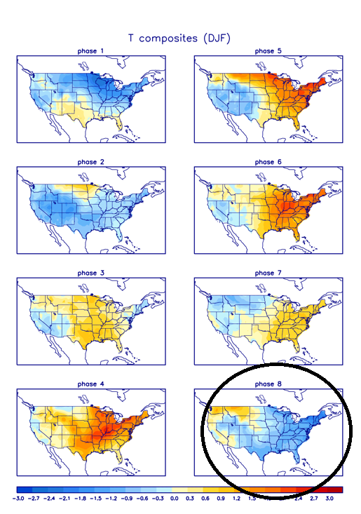
So in short, keep looking for the models to see the big Alaskan ridge and surface high pressure domes. The storms will come as long as the arctic boundary is there but details likely change many times.
Moderator: S2k Moderators
 The posts in this forum are NOT official forecast and should not be used as such. They are just the opinion of the poster and may or may not be backed by sound meteorological data. They are NOT endorsed by any professional institution or STORM2K.


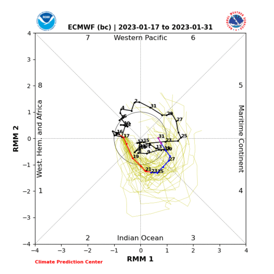
Ntxw wrote:I'd caution again 300+ hour GFS on a small scale. However, ensembles are a good deal with some skill. GEFS and EPS have a poleward -EPO ridge. Mentioned a few days ago to start looking for big 1050+HP coming from the north on Guidance. Surely enough they are starting to show up. Such a pattern is cross polar flow with air coming out of the Arctic and even Siberia. The potential is there for a deep freeze type outbreak, assuming it plays out that way. At minimum a couple of strong arctic fronts down the plains so likely coldest air of the season yet.
http://i66.tinypic.com/2zgsown.png
http://i64.tinypic.com/65vdhl.png
So in short, keep looking for the models to see the big Alaskan ridge and surface high pressure domes. The storms will come as long as the arctic boundary is there but details likely change many times.
Tejas89 wrote:DFW will tease a record high today. Some interesting stats on records since 2000...
- 85 of our record daily highs have been set since 2000, compared to 14 of the record lows.
- August and September combined account for a whopping 32 of the record highs, and 0 of the lows.
- DJF combined account for 24 of the highs, and 3 of the lows.
bubba hotep wrote:Just shift it east a bit and I'm all in! lol
http://maps1.pivotalweather.com/maps/mo ... .us_sc.png


EnnisTx wrote:bubba hotep wrote:Just shift it east a bit and I'm all in! lol
http://maps1.pivotalweather.com/maps/mo ... .us_sc.png
I'll take it! What a nice little surprise that would be...
wxman57 wrote:EnnisTx wrote:bubba hotep wrote:Just shift it east a bit and I'm all in! lol
http://maps1.pivotalweather.com/maps/mo ... .us_sc.png
I'll take it! What a nice little surprise that would be...
Careful with those pivotalweather snowfall graphics - they are created using the GFS but apparently only look at projected surface temperatures. The sub-freezing layer at the surface is only 1000-2000 feet thick. Above that is air that's well above freezing in the precip column. Therefore, the GFS is forecasting widespread freezing rain, not heavy snow.
ThunderSleetDreams wrote:12z is showing an additional front at hour 168 coming through Texas. That was not there before...
Highs in the 50s instead of the upper 60s/70s early next week.
Ralph's Weather wrote:ThunderSleetDreams wrote:12z is showing an additional front at hour 168 coming through Texas. That was not there before...
Highs in the 50s instead of the upper 60s/70s early next week.
Noticed that front in recent runs. If it can phase with the SW low then that could be a set-up for a good winter storm otherwise some storms followed by colder temps.


Users browsing this forum: Google [Bot] and 91 guests


