Texas Winter 2017-2018

Winter Weather Discussion

Moderator: S2k Moderators

Forum rules

The posts in this forum are NOT official forecast and should not be used as such. They are just the opinion of the poster and may or may not be backed by sound meteorological data. They are NOT endorsed by any professional institution or STORM2K.

Help Support Storm2K
Message
Author
Cpv17
Category 5
Category 5
Posts: 4313
Joined: Wed Dec 07, 2016 2:24 pm
Location: Wharton/El Campo, TX

Re: Texas Winter 2017-2018

#2141 Postby Cpv17 » Sat Dec 16, 2017 5:42 pm

ThunderSleetDreams wrote:Temp output on this run is trash... next run

Front stalls as for 4 days on the TX/LA border... yeah, no, that isn’t happening

The models have pretty much been consistently showing that the coldest anomalies have a very hard time making it east of the I-35 corridor. Coldest anomalies have been confined to the hill country and west TX.
0 likes   

User avatar
ThunderSleetDreams
S2K Supporter
S2K Supporter
Posts: 1398
Age: 41
Joined: Tue Dec 20, 2011 4:42 pm
Location: S of Weimar, TX

Re: Texas Winter 2017-2018

#2142 Postby ThunderSleetDreams » Sat Dec 16, 2017 5:44 pm

Cpv17 wrote:
ThunderSleetDreams wrote:Temp output on this run is trash... next run

Front stalls as for 4 days on the TX/LA border... yeah, no, that isn’t happening

The models have pretty much been consistently showing that the coldest anomalies have a very hard time making it east of the I-35 corridor. Coldest anomalies have been confined to the hill country and west TX.


Your statement is different than what I’m questioning. I think the anomalies will be more extreme. Arctic fronts just don’t hang up on the gulf coast. They slide right into it.
1 likes   
#NeverSummer

I hibernate when it gets above 75 degrees!

User avatar
iorange55
Category 5
Category 5
Posts: 2349
Joined: Thu Nov 13, 2008 9:47 pm
Location: Big D

Re: Texas Winter 2017-2018

#2143 Postby iorange55 » Sat Dec 16, 2017 5:47 pm

The mid-range curse is real. :lol:

On a serious note: It’s all still there. Precip, cold air, two storms...the temps will go up and down for the next few days until we get closer.
1 likes   

ronyan
S2K Supporter
S2K Supporter
Posts: 791
Age: 37
Joined: Tue Sep 09, 2008 5:46 pm
Location: Lake Jackson, TX

Re: Texas Winter 2017-2018

#2144 Postby ronyan » Sat Dec 16, 2017 5:49 pm

Image

This looks fairly extreme. Also no hint of +PNA in this forecast.
Last edited by ronyan on Sat Dec 16, 2017 5:50 pm, edited 1 time in total.
3 likes   

User avatar
cheezyWXguy
Category 5
Category 5
Posts: 5528
Joined: Mon Feb 13, 2006 12:29 am
Location: Dallas, TX

Re: Texas Winter 2017-2018

#2145 Postby cheezyWXguy » Sat Dec 16, 2017 5:50 pm

One thing that bothers me is that the GFS loses all consistency on its handling of the ULL once it reaches Arizona. It has been rather consistent up until that point, but afterward, the evolution is dramatically different with each run. Back to back runs have showed it either swinging through, immediately shearing out, or even retrograding SW until its well off the coast of California.
0 likes   

Cpv17
Category 5
Category 5
Posts: 4313
Joined: Wed Dec 07, 2016 2:24 pm
Location: Wharton/El Campo, TX

Re: Texas Winter 2017-2018

#2146 Postby Cpv17 » Sat Dec 16, 2017 5:54 pm

ThunderSleetDreams wrote:
Cpv17 wrote:
ThunderSleetDreams wrote:Temp output on this run is trash... next run

Front stalls as for 4 days on the TX/LA border... yeah, no, that isn’t happening

The models have pretty much been consistently showing that the coldest anomalies have a very hard time making it east of the I-35 corridor. Coldest anomalies have been confined to the hill country and west TX.


Your statement is different than what I’m questioning. I think the anomalies will be more extreme. Arctic fronts just don’t hang up on the gulf coast. They slide right into it.

Oh I totally agree with you. It makes no sense for an Artic airmass to just hang up like that. I was just stating what the models have been showing.
1 likes   

Ntxw
Storm2k Moderator
Storm2k Moderator
Posts: 21500
Joined: Wed Oct 21, 2009 6:34 pm
Location: DFW, Texas

Re: Texas Winter 2017-2018

#2147 Postby Ntxw » Sat Dec 16, 2017 6:00 pm

ronyan wrote:Image

This looks fairly extreme. Also no hint of +PNA in this forecast.


-400s for the ESRL is fairly rare. I think only one instance has it gone -4SD or more for the EPO, I'd have to go back and look at the daily values.
1 likes   
The above post and any post by Ntxw is NOT an official forecast and should not be used as such. It is just the opinion of the poster and may or may not be backed by sound meteorological data. It is NOT endorsed by any professional institution including Storm2k. For official information, please refer to NWS products.

  Help support Storm2K!
Help Support Storm2K

ronyan
S2K Supporter
S2K Supporter
Posts: 791
Age: 37
Joined: Tue Sep 09, 2008 5:46 pm
Location: Lake Jackson, TX

Re: Texas Winter 2017-2018

#2148 Postby ronyan » Sat Dec 16, 2017 6:13 pm

Ntxw wrote:
ronyan wrote:https://preview.ibb.co/kZOZ76/4indices_1.png

This looks fairly extreme. Also no hint of +PNA in this forecast.


-400s for the ESRL is fairly rare. I think only one instance has it gone -4SD or more for the EPO, I'd have to go back and look at the daily values.


Decmeber 2009 is the last time I see for -4SDs. -5SD occurred in December 1983. Is there a way to query this data? If not I may build a page for efficient search of the daily values.
Last edited by ronyan on Sat Dec 16, 2017 6:19 pm, edited 1 time in total.
0 likes   

stormlover2013
Category 5
Category 5
Posts: 2312
Joined: Thu Aug 22, 2013 12:06 pm
Location: Lumberton, Texas

Re: Texas Winter 2017-2018

#2149 Postby stormlover2013 » Sat Dec 16, 2017 6:16 pm

Gfs new run isn’t anything special
0 likes   

User avatar
JDawg512
Category 5
Category 5
Posts: 1032
Age: 44
Joined: Mon Aug 26, 2013 8:56 pm
Location: Austin
Contact:

Re: Texas Winter 2017-2018

#2150 Postby JDawg512 » Sat Dec 16, 2017 6:26 pm

Rain has really picked up in intensity over the last 30-45 min. Heavy rain falling. It's a good thing it's not at or below freezing today. As I said lastnight, love rain as long as it stays liquid...
2 likes   
Resident Rain Miser

I am a weather hobbyist living 3.5 miles south of Downtown Austin and in no way or fashion should anything I say concerning forecasts be taken seriously. Please check your local NWS for accurate weather forecasting and conditions.

User avatar
JDawg512
Category 5
Category 5
Posts: 1032
Age: 44
Joined: Mon Aug 26, 2013 8:56 pm
Location: Austin
Contact:

Re: Texas Winter 2017-2018

#2151 Postby JDawg512 » Sat Dec 16, 2017 6:31 pm

So far just passing an inch here at the Rain Cave. Keep it coming!
3 likes   
Resident Rain Miser

I am a weather hobbyist living 3.5 miles south of Downtown Austin and in no way or fashion should anything I say concerning forecasts be taken seriously. Please check your local NWS for accurate weather forecasting and conditions.

Ntxw
Storm2k Moderator
Storm2k Moderator
Posts: 21500
Joined: Wed Oct 21, 2009 6:34 pm
Location: DFW, Texas

Re: Texas Winter 2017-2018

#2152 Postby Ntxw » Sat Dec 16, 2017 6:35 pm

ronyan wrote:
Ntxw wrote:
ronyan wrote:https://preview.ibb.co/kZOZ76/4indices_1.png

This looks fairly extreme. Also no hint of +PNA in this forecast.


-400s for the ESRL is fairly rare. I think only one instance has it gone -4SD or more for the EPO, I'd have to go back and look at the daily values.


Decmeber 2009 is the last time I see for -4SDs. -5SD occurred in December 1983. Is there a way to query this data? If not I may build a page for efficient search of the daily values.


Unfortunately the EPO is not one records are kept as well as others that benefit the east coast (Atlantic indexes )such as NAO/AO. You will get a variety of NAO data and pages but not so much the EPO.
0 likes   
The above post and any post by Ntxw is NOT an official forecast and should not be used as such. It is just the opinion of the poster and may or may not be backed by sound meteorological data. It is NOT endorsed by any professional institution including Storm2k. For official information, please refer to NWS products.


  Help support Storm2K!

Help Support Storm2K


Cpv17
Category 5
Category 5
Posts: 4313
Joined: Wed Dec 07, 2016 2:24 pm
Location: Wharton/El Campo, TX

Re: Texas Winter 2017-2018

#2153 Postby Cpv17 » Sat Dec 16, 2017 6:37 pm

stormlover2013 wrote:Gfs new run isn’t anything special

That’s because it’s in the mid range. The GFS has been horrible with the mid range forecast. Every single time it gets within 5 to 10 days from happening the GFS completely loses the storm and the cold air. That’s why we shouldn’t really take it seriously right now. By Wednesday we will know a lot more. Literally from hours 240 to 384 the GFS will have the brutal cold and then once it gets under 240 it will slowly start to lose it with each passing run. This is normal. Nothing surprising. For example, at hour 276 on the latest run of the GFS it has the DFW area at 29 degrees. If we forward the clock to Monday evening, 48 hours from now would be at hour 228 & I bet that 29 degrees will be more like in the mid 30’s.
2 likes   

aggiecutter
Category 5
Category 5
Posts: 1743
Joined: Thu Oct 14, 2004 9:22 pm
Location: Texarkana

Re: Texas Winter 2017-2018

#2154 Postby aggiecutter » Sat Dec 16, 2017 6:50 pm

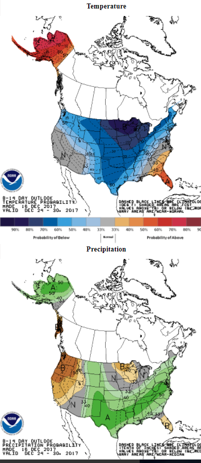
Can you say southern plains major winter storm. Yes, you can:

Image
3 likes   

Cpv17
Category 5
Category 5
Posts: 4313
Joined: Wed Dec 07, 2016 2:24 pm
Location: Wharton/El Campo, TX

Re: Texas Winter 2017-2018

#2155 Postby Cpv17 » Sat Dec 16, 2017 6:53 pm

You beat me to it lol I was just about to post that.
0 likes   

Ntxw
Storm2k Moderator
Storm2k Moderator
Posts: 21500
Joined: Wed Oct 21, 2009 6:34 pm
Location: DFW, Texas

Re: Texas Winter 2017-2018

#2156 Postby Ntxw » Sat Dec 16, 2017 7:58 pm

While we wait for the 0z runs

From Dr. Ventrice

 https://twitter.com/MJVentrice/status/942110852039274506


0 likes   
The above post and any post by Ntxw is NOT an official forecast and should not be used as such. It is just the opinion of the poster and may or may not be backed by sound meteorological data. It is NOT endorsed by any professional institution including Storm2k. For official information, please refer to NWS products.


  Help support Storm2K!

Help Support Storm2K


User avatar
SnowintheFalls
S2K Supporter
S2K Supporter
Posts: 249
Age: 46
Joined: Fri Nov 22, 2013 5:06 pm
Location: Burkburnett, TX

Re: Texas Winter 2017-2018

#2157 Postby SnowintheFalls » Sat Dec 16, 2017 9:05 pm

Is it sad that here it is Saturday night and all I can seem to think about is what the 0z will bring?? The anticipation for each run is brutal at this point! :lol:
4 likes   
There is no day like a snow day!

User avatar
South Texas Storms
Professional-Met
Professional-Met
Posts: 4005
Joined: Thu Jun 24, 2010 12:28 am
Location: Houston, TX

Re: Texas Winter 2017-2018

#2158 Postby South Texas Storms » Sat Dec 16, 2017 9:10 pm

SnowintheFalls wrote:Is it sad that here it is Saturday night and all I can seem to think about is what the 0z will bring?? The anticipation for each run is brutal at this point! :lol:


No I think most of us feel the same way! :lol:
0 likes   

User avatar
wxman57
Moderator-Pro Met
Moderator-Pro Met
Posts: 22480
Age: 66
Joined: Sat Jun 21, 2003 8:06 pm
Location: Houston, TX (southwest)

Re: Texas Winter 2017-2018

#2159 Postby wxman57 » Sat Dec 16, 2017 9:21 pm

South Texas Storms wrote:
SnowintheFalls wrote:Is it sad that here it is Saturday night and all I can seem to think about is what the 0z will bring?? The anticipation for each run is brutal at this point! :lol:


No I think most of us feel the same way! :lol:


I will sleep just fine. I can wait until Thursday for the mesoscale models to come into play. Nothing that comes in overnight will mean anything as far as next weekend.
5 likes   

User avatar
Tireman4
S2K Supporter
S2K Supporter
Posts: 5674
Age: 58
Joined: Fri Jun 30, 2006 1:08 pm
Location: Humble, Texas
Contact:

Re: Texas Winter 2017-2018

#2160 Postby Tireman4 » Sat Dec 16, 2017 9:34 pm

wxman57 wrote:
South Texas Storms wrote:
SnowintheFalls wrote:Is it sad that here it is Saturday night and all I can seem to think about is what the 0z will bring?? The anticipation for each run is brutal at this point! :lol:


No I think most of us feel the same way! :lol:


I will sleep just fine. I can wait until Thursday for the mesoscale models to come into play. Nothing that comes in overnight will mean anything as far as next weekend.


And that my friends are the wise words of a grizzled vet. He knows not to even worry until late week. I totally agree with him. This is all just eye candy until the later week models come in.
1 likes   


Return to “Winter Weather”

Who is online

Users browsing this forum: No registered users and 69 guests