Southern Plains winter wx thread (2009-2010)
Moderator: S2k Moderators
Forum rules
 The posts in this forum are NOT official forecast and should not be used as such. They are just the opinion of the poster and may or may not be backed by sound meteorological data. They are NOT endorsed by any professional institution or STORM2K.

The posts in this forum are NOT official forecast and should not be used as such. They are just the opinion of the poster and may or may not be backed by sound meteorological data. They are NOT endorsed by any professional institution or STORM2K.
-
Extremeweatherguy

- Category 5

- Posts: 11095
- Joined: Mon Oct 10, 2005 8:13 pm
- Location: Houston, TX
Re: Southern Plains winter wx thread (2009-2010)
The last few runs of the GFS have been looking real interesting toward the later part of next week. It appears as though there may be a pretty strong front coming through and possibly even some early season winter precipitation into the southern plains. It will be interesting to watch the model trends over the next several days to see if this actually ends up morphing into viable scenario or not.
0 likes
-
Extremeweatherguy
- Category 5
- Posts: 11095
- Joined: Mon Oct 10, 2005 8:13 pm
- Location: Houston, TX
Re: Southern Plains winter wx thread (2009-2010)
Tonight's 00z run of the GFS continues to indicate the coldest airmass of the season arriving across the southern plains late next week. If the run is correct, then there may be a threat for wintry precipitation as far south as parts of Oklahoma, and a freeze threat could extend all the way into North Texas by next Saturday (Halloween).
0 likes
Re: Southern Plains winter wx thread (2009-2010)
This is the worst october I've ever seen 
Look at this...

Look at this...
Through the first 16 days of the month, the average temperature in Wichita is 58.6 degrees. This is 11.4 degrees below normal. This ranks as the coldest start to the month of October since records began in Wichita in 1888. The previous coldest start through the first 16 days was 64.4 degrees set in 1925.
0 likes

-
Extremeweatherguy
- Category 5
- Posts: 11095
- Joined: Mon Oct 10, 2005 8:13 pm
- Location: Houston, TX
Re: Southern Plains winter wx thread (2009-2010)
After experiencing our 2nd coldest October in history, there is now no winter weather in sight for Oklahoma City. The forecast through the end of the week and into the weekend calls for highs to remain in the 70s under sunny skies.
0 likes
-
Extremeweatherguy
- Category 5
- Posts: 11095
- Joined: Mon Oct 10, 2005 8:13 pm
- Location: Houston, TX
Re: Southern Plains winter wx thread (2009-2010)
If the strong upper low the 18z GFS is showing plays out, then it might get interesting across the southern plains in 5-6 days...
120 hrs
Surface - http://www.nco.ncep.noaa.gov/pmb/nwprod ... n_120l.gif
850mb - http://www.nco.ncep.noaa.gov/pmb/nwprod ... p_120l.gif
500mb - http://www.nco.ncep.noaa.gov/pmb/nwprod ... 0_120l.gif
1000mb to 500mb thickness - http://www.nco.ncep.noaa.gov/pmb/nwprod ... p_120l.gif
132 hrs
Surface - http://www.nco.ncep.noaa.gov/pmb/nwprod ... n_132l.gif
850mb - http://www.nco.ncep.noaa.gov/pmb/nwprod ... p_132l.gif
500mb - http://www.nco.ncep.noaa.gov/pmb/nwprod ... 0_132l.gif
1000mb to 500mb thickness - http://www.nco.ncep.noaa.gov/pmb/nwprod ... p_132l.gif
144 hrs
Surface - http://www.nco.ncep.noaa.gov/pmb/nwprod ... n_144l.gif
850mb - http://www.nco.ncep.noaa.gov/pmb/nwprod ... p_144l.gif
500mb - http://www.nco.ncep.noaa.gov/pmb/nwprod ... 0_144l.gif
1000mb to 500mb thickness - http://www.nco.ncep.noaa.gov/pmb/nwprod ... p_144l.gif
The result of this scenario would be --> A big snowstorm into Kansas and the Oklahoma panhandle, with periods of mixing precipitation-types as far south as northern/central Oklahoma.
0 likes
-
Extremeweatherguy
- Category 5
- Posts: 11095
- Joined: Mon Oct 10, 2005 8:13 pm
- Location: Houston, TX
Re: Southern Plains winter wx thread (2009-2010)
The 00z GFS run continues the wintry trend, showing a decent chance for snow (or rain mixing with snow) across most of west and northwest Oklahoma next Monday...
http://www.nco.ncep.noaa.gov/pmb/nwprod ... p_138l.gif
http://www.nco.ncep.noaa.gov/pmb/nwprod ... 0_138l.gif
http://www.nco.ncep.noaa.gov/pmb/nwprod ... p_138l.gif
http://www.nco.ncep.noaa.gov/pmb/nwprod ... 0_138l.gif
0 likes
-
Extremeweatherguy
- Category 5
- Posts: 11095
- Joined: Mon Oct 10, 2005 8:13 pm
- Location: Houston, TX
Re: Southern Plains winter wx thread (2009-2010)
Today's 12z run of the GFS is a little further north with the upper system, bringing the best chance of wintry precipitation to Kansas and Nebraska.
http://www.nco.ncep.noaa.gov/pmb/nwprod ... 0_126l.gif
http://www.nco.ncep.noaa.gov/pmb/nwprod ... 0_126l.gif
0 likes
-
Extremeweatherguy
- Category 5
- Posts: 11095
- Joined: Mon Oct 10, 2005 8:13 pm
- Location: Houston, TX
Re: Southern Plains winter wx thread (2009-2010)
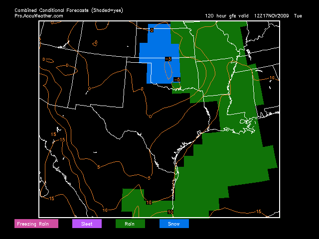
The 12z GFS continues to look interesting, It is once again bringing the upper low far enough south to have mixed precipitation reach central Oklahoma, including OKC.
http://i43.photobucket.com/albums/e371/ ... ombine.png
The GFS MOS is starting to trend much colder/wetter too. The latest 12Z MOS is calling for a high of 44F in Oklahoma City on Monday with an 80%+ chance of precipitation. Which, even if the precipitation is in the form of rain, will make for a cold/raw/wet day.
0 likes
-
Extremeweatherguy
- Category 5
- Posts: 11095
- Joined: Mon Oct 10, 2005 8:13 pm
- Location: Houston, TX
The 18Z GFS would be awesome. Check out what it is showing for OKC...
MON 12Z 16-NOV 3.2 -2.3 1022 91 90 0.18 558 540
MON 18Z 16-NOV 3.1 -4.2 1024 92 87 0.17 558 538
TUE 00Z 17-NOV 4.0 -3.3 1024 92 97 0.04 557 538
TUE 06Z 17-NOV 3.8 -3.0 1023 87 94 0.01 557 538
TUE 12Z 17-NOV 2.2 -3.2 1023 86 75 0.01 555 537
TUE 18Z 17-NOV 4.6 -3.7 1022 76 95 0.01 557 539
WED 00Z 18-NOV 3.3 -4.4 1021 85 95 0.05 556 539
Thicknesses at or below 540 and 850mb temperatures below 0C from Monday morning through Tuesday evening! During the same time period it also drops nearly half an inch of (liquid equivalent) precipitation. With such low thicknesses and 850mb temperatures, as well as with the surface air in the 30s, most of the precipitation would likely fall as either sleet or snow or a mix with rain.
The NWS in Norman is not biting onto this kind of scenario for central Oklahoma just yet, but if the models can continue to trend this way, then they may need to change their tune in the coming days.
0 likes
-
Extremeweatherguy
- Category 5
- Posts: 11095
- Joined: Mon Oct 10, 2005 8:13 pm
- Location: Houston, TX
Re: Southern Plains winter wx thread (2009-2010)
00z GFS - stalls the upper low right over Oklahoma. Several days of clouds, cold, and precipitation chances (some of which may be in the form of sleet/snow) will be in store if this plays out.
0 likes
-
Extremeweatherguy
- Category 5
- Posts: 11095
- Joined: Mon Oct 10, 2005 8:13 pm
- Location: Houston, TX
Re: Southern Plains winter wx thread (2009-2010)
The NWS in Norman is now officially mentioning the potential for a rain/snow mix in OKC on Monday night. 
0 likes
-
srainhoutx

- S2K Supporter

- Posts: 6919
- Age: 66
- Joined: Sun Jan 14, 2007 11:34 am
- Location: Haywood County, NC
- Contact:
Re: Southern Plains winter wx thread (2009-2010)
Snipet from Wichita, KS this morning...
HOWEVER...THINGS COULD START
CHANGING OVER TO SNOW SUNDAY NIGHT INTO MONDAY OVER CENTRAL AND
PORTIONS OF SOUTH CENTRAL KANSAS WITH EVEN SOME INSTABILITY POSSIBLE
ABOVE 700MB. GFS IS ALSO SHOWING GOOD VERTICAL MOTION AT -15DEG C
WHICH WILL AID IN GOOD DENDRITIC GROWTH. AS A RESULT...WE WENT AHEAD
AND MENTION A GOOD CHANCE FOR ALL SNOW ON SUNDAY NIGHT INTO MONDAY
IN CENTRAL KANSAS. ELSEWHERE...WE ARE MENTIONING MAINLY RAIN SINCE
IT APPEARS THAT THE COLDEST AIR WILL BE ALONG AND WEST OF THE
I-35/I-135 CORRIDOR. THE GFS IS ALSO SHOWING UP TO A FOOT OF SNOW IN
THAT AREA. IF THE MODELS STICK WITH THIS TREND...WE MAY END UP
ISSUING A WINTER STORM WATCH IN LATER SHIFTS
0 likes
Carla/Alicia/Jerry(In The Eye)/Michelle/Charley/Ivan/Dennis/Katrina/Rita/Wilma/Ike/Harvey
Member: National Weather Association
Wx Infinity Forums
http://wxinfinity.com/index.php
Facebook.com/WeatherInfinity
Twitter @WeatherInfinity
Member: National Weather Association
Wx Infinity Forums
http://wxinfinity.com/index.php
Facebook.com/WeatherInfinity
Twitter @WeatherInfinity
-
Extremeweatherguy
- Category 5
- Posts: 11095
- Joined: Mon Oct 10, 2005 8:13 pm
- Location: Houston, TX
Re: Southern Plains winter wx thread (2009-2010)
It is starting to look more and more likely that OKC will be dry-slotted just as the atmosphere is becoming cold enough for a changeover or mixing with snow early next week.  I am still holding out hope though that we will at least get a flurry or two out of this! We'll see..
Either way, it's definitely going to be a chilly few days compared to what we've experienced recently. The latest NWS forecast is calling for three back-to-back afternoons with sub-50F high temperatures.
Either way, it's definitely going to be a chilly few days compared to what we've experienced recently. The latest NWS forecast is calling for three back-to-back afternoons with sub-50F high temperatures.
0 likes
-
Extremeweatherguy
- Category 5
- Posts: 11095
- Joined: Mon Oct 10, 2005 8:13 pm
- Location: Houston, TX
Re: Southern Plains winter wx thread (2009-2010)
I never wound up getting any noticeable flakes, but it was quite chilly. Highs today remained in the lower to middle 40s under cloudy skies and brisk north winds. Wind chills ranged between 28-35F all day! Brrr.
The first freeze of the season is also now forecast to arrive tomorrow night. It is overdue by about 2 weeks.
The first freeze of the season is also now forecast to arrive tomorrow night. It is overdue by about 2 weeks.
Tuesday Night: Partly cloudy, with a low around 30. North northwest wind between 5 and 8 mph.
0 likes
-
Extremeweatherguy
- Category 5
- Posts: 11095
- Joined: Mon Oct 10, 2005 8:13 pm
- Location: Houston, TX
Re: Southern Plains winter wx thread (2009-2010)
The models continue to indicate a change to a MUCH colder pattern starting next week. If the latest GFS and GFS MOS are correct, then we could see several back-to-back below normal days next week into the week after with sub-50F highs and sub-freezing lows becoming a common sight in central Oklahoma. There might even be a few winter weather episodes mixed in from time to time.
Below is a look at the highs and lows the 12z GFS is showing for OKC during the first part of next week...
Sun (Nov 29th)
High - 51F
Low - 42F
Mon (Nov 30th)
High - 43F
Low - 34F
Tues (Dec 1st)
High - 46F
Low - 27F
Wed (Dec 2nd)
High - 47F
Low - 35F
Thurs (Dec 3rd)
High - 45F
Low - 32F
...Beyond this timeframe, the GFS hints at it becoming even colder than this, with several sub-40F days possible the 2nd week of December (and increased winter weather threats). It will be interesting to watch and see how all of this evolves in the coming days, and whether or not such a scenario can actually manage to play out. If it can, then this will be a very fun period for southern plains winter weather lovers.
UPDATE (11/29/09): It looks like the first part of this week will be warmer than the initial ECMWF output referenced above. The mid/later part could be as cold or colder than the output though.
Last edited by Extremeweatherguy on Sun Nov 29, 2009 10:05 pm, edited 1 time in total.
0 likes
-
Extremeweatherguy
- Category 5
- Posts: 11095
- Joined: Mon Oct 10, 2005 8:13 pm
- Location: Houston, TX
Re: Southern Plains winter wx thread (2009-2010)
Today's 12z ECMWF looks very chilly for the end of next week. Starting Wednesday it quickly begins a downward trend in 850mb temperatures and thicknesses over OKC, and by Friday the 850mb temperature over the area is approaching -7C and the thickness is well into the 520s! If this scenario winds up playing out, then it will definitely be getting very cold across the southern plains. To make things even more interesting though, the ECMWF also shows increasing moisture by the end of next week with a RH of 100% at 700mb by 12z Friday and a RH of 92% at 850mb. This indicates thick cloud cover and likely precipitation over Oklahoma City during that timeframe, which if the upper temperatures and thicknesses are correct, would be falling in the form of snow. This is definitely worth keeping an eye on over the next few days!
UPDATE: The 00Z ECMWF is not quite as extreme. Still quite cold, but no widespread snow on Friday in this run. May be a slight chance on Wed/Thurs though if the upper low tracks the way it is showing.
UPDATE: The 00Z ECMWF is not quite as extreme. Still quite cold, but no widespread snow on Friday in this run. May be a slight chance on Wed/Thurs though if the upper low tracks the way it is showing.
Last edited by Extremeweatherguy on Sat Nov 28, 2009 1:48 am, edited 2 times in total.
0 likes
-
Extremeweatherguy
- Category 5
- Posts: 11095
- Joined: Mon Oct 10, 2005 8:13 pm
- Location: Houston, TX
From the Wichita, KS Afternoon AFD...
TUESDAY NIGHT-FRIDAY:
THINGS ARE STILL LOOKING VERY INTERESTING DURING THIS TIMEFRAME. THE
ECMWF/ECMWF ENSEMBLES ARE STILL ADVERTISING AN ANOMALOUS UPPER LEVEL
RIDGE BUILDING OVER THE ROCKIES WITH A CORRESPONDING ANOMALOUS UPPER
LEVEL TROF DEVELOPING OVER THE PLAINS. MEANWHILE...THE OPERATIONAL
GFS HAS BEEN LEANING TOWARD A MORE PROGRESSIVE SOLUTION WITH THE
UPPER LEVEL TROF FURTHER EAST. HOWEVER...THE GFS ENSEMBLES ARE
STARTING TO LEAN TOWARDS THE ECMWF SOLUTION. WE ARE LEANING CLOSEST
TO THE OPERATIONAL ECMWF/ECMWF ENSEMBLES AT THIS TIME WHICH WOULD
FAVOR POLAR AIR MOVING SOUTH OUT OF SASKATCHEWAN/ALBERTA INTO THE
AREA STARTING WEDNESDAY AND CONTINUING THROUGH THE WEEKEND. THE
TIMING OF THIS FRONT IS QUITE TRICKY AT THIS POINT...ESPECIALLY
SINCE THESE BOUNDARIES TEND TO MOVE THROUGH QUICKER THAN THE
MODELS PROJECT. THE ECMWF SHOWS THE INITIAL SURGE OF COLD AIR
MOVING THROUGH ON TUESDAY NIGHT WITH MORE COLDER AIR POURING IN ON
THURSDAY...AS ANOTHER SYSTEM SURGES SOUTH FROM THE NORTHERN
ROCKIES. THE ECMWF DOES SHOW SOME ELEVATED WARM AIR ADVECTION
TAKING PLACE ACROSS THIS COLD DOME WHICH COULD MAKE THINGS MESSY.
WE WILL NOT INTRODUCE POPS AT THIS POINT...BUT IT CERTAINLY BEARS
WATCHING. WE DROPPED TEMPERATURES SEVERAL DEGREES DURING THIS PERIOD
SINCE WE ARE FAVORING THE ECMWF DURING THIS PERIOD.
0 likes

Re: Southern Plains winter wx thread (2009-2010)
Tues-Weds time frame from OKC AFD
THE NAM`S THICKNESS PARAMETERS SUGGEST A MIX OF RAIN AND SNOW
COULD OCCUR OVER PARTS OF SOUTHWEST OKLAHOMA AND WESTERN NORTH
TEXAS FOR A SHORT TIME WEDNESDAY MORNING AS COLDER TEMPERATURES
ALOFT... ASSOCIATED WITH THE UPPER LOW... MOVE ACROSS. THE NAM`S BOUNDARY
LAYER TEMPERATURES ARE FORECAST TO BE ONLY SLIGHTLY ABOVE
FREEZING AT THAT TIME. MEANWHILE... THE GFS 850 TO 700 MB
THICKNESSES ARE ALSO COLD ENOUGH TO SUPPORT SNOW... HOWEVER THE
LOWER LEVELS ARE WARMER THAN THE NAM FOR WEDNESDAY MORNING. GIVEN
THE UNCERTAINTY WITH THE TIMING OF THE UPPER LOW AND ITS JUXTAPOSITION
WITH THE VARIOUS THICKNESS/LOW LEVEL TEMPERATURE PARAMETERS AND QPF...
WE WILL NOT GET AGGRESSIVE WITH THIS EVENT ATTM... BUT WILL
INTRODUCE A MIX OF RAIN AND WET SNOW FOR A SHORT WHILE WEDNESDAY
MORNING. GIVEN THE MARGINALLY COLD LOW LEVEL TEMPERATURES AND
RELATIVELY MILD GROUND TEMPERATURES... DOUBT THAT ANY SNOW THAT
MIGHT OCCUR WILL STAY AROUND VERY LONG. HAVING SAID THAT... WE
WILL NEED TO MONITOR A COLD FRONT THAT IS FORECAST TO DROP INTO
KANSAS LATE IN THE DAY TUESDAY AND MOVE INTO THE CWA TUESDAY NIGHT
AND EARLY WEDNESDAY. IF THIS AIR ARRIVES COLDER THAN EXPECTED...
IT COULD RESULT IN SOME EXPANSION OF THE MIXED PRECIPITATION AREA.
0 likes
The above post and any post by Ntxw is NOT an official forecast and should not be used as such. It is just the opinion of the poster and may or may not be backed by sound meteorological data. It is NOT endorsed by any professional institution including Storm2k. For official information, please refer to NWS products.
Help support Storm2K!
-
Extremeweatherguy
- Category 5
- Posts: 11095
- Joined: Mon Oct 10, 2005 8:13 pm
- Location: Houston, TX
One thing's for sure - the airmass behind this system is looking colder and colder with each new model run. Instead of the bulk of the cold being shunted well east of here, the model runs are now showing more of a direct impact on the southern plains. This is not true arctic air, but it will still be capable of producing the coldest temperatures of the season (so far) for the entire area.
Here is a look at some of the latest model data...
00z NAM:
Cold air pouring down the plains on Thursday morning -
500mb: http://www.nco.ncep.noaa.gov/pmb/nwprod ... 0_084l.gif
850mb: http://www.nco.ncep.noaa.gov/pmb/nwprod ... p_084l.gif
Thickness: http://www.nco.ncep.noaa.gov/pmb/nwprod ... p_084l.gif
00z GFS:
Like the NAM, the GFS is also showing a big push of cold air on Thursday morning -
500mb: http://www.nco.ncep.noaa.gov/pmb/nwprod ... 0_084l.gif
850mb: http://www.nco.ncep.noaa.gov/pmb/nwprod ... p_084l.gif
Thickness: http://www.nco.ncep.noaa.gov/pmb/nwprod ... p_084l.gif
102 hours out-
500mb: http://www.nco.ncep.noaa.gov/pmb/nwprod ... 0_102l.gif
850mb: http://www.nco.ncep.noaa.gov/pmb/nwprod ... p_102l.gif
Thickness: http://www.nco.ncep.noaa.gov/pmb/nwprod ... p_102l.gif
Freeze threats are likely well into central and southeast Texas with a setup like this, and north Texas into Oklahoma might be looking at 2-3 mornings of hard freezes.
Last edited by Extremeweatherguy on Sun Nov 29, 2009 11:38 pm, edited 1 time in total.
0 likes
Re: Southern Plains winter wx thread (2009-2010)
BRR!
0 likes
The above post and any post by Ntxw is NOT an official forecast and should not be used as such. It is just the opinion of the poster and may or may not be backed by sound meteorological data. It is NOT endorsed by any professional institution including Storm2k. For official information, please refer to NWS products.
Help support Storm2K!
Help support Storm2K!
Who is online
Users browsing this forum: No registered users and 12 guests