Winter 2010-11 for the Southern Plains

Winter Weather Discussion

Moderator: S2k Moderators

Forum rules

The posts in this forum are NOT official forecast and should not be used as such. They are just the opinion of the poster and may or may not be backed by sound meteorological data. They are NOT endorsed by any professional institution or STORM2K.

Help Support Storm2K
Message
Author
User avatar
Portastorm
Storm2k Moderator
Storm2k Moderator
Posts: 9787
Age: 61
Joined: Fri Jul 11, 2003 9:16 am
Location: South Austin, TX
Contact:

Re:

#21 Postby Portastorm » Sun Aug 08, 2010 10:54 am

CaptinCrunch wrote:The only good thing La Nina winters have going for them are the chance of a buckeled N jet stream that dumps arctic air into the deep south. While we trend to be warmer and drier during La Nina winters, the chance for extreme arctic outbreaks for short periods of time are higher, but winter precip chances are much lower due to the storm track being across the mid section of the U.S.


Exactly Captin ... La Nina winters can feature those really fun (well at least I think they are) Arctic outbreaks in Texas where we have temps in the 70s and then within 6-12 hours, they drop into the 20s or 30s. Those types of events never cease to amaze me.

I do expect a few dramatic outbreaks of very cold air with a frozen precip threat or two ... but the bulk of the winter for Texas will probably be "Chamber of Commerce" type weather for the snowbirds.
0 likes   

User avatar
CaptinCrunch
S2K Supporter
S2K Supporter
Posts: 8579
Age: 56
Joined: Mon Nov 03, 2003 4:33 pm
Location: Lake Worth, TX (Tarrant Co.)

#22 Postby CaptinCrunch » Wed Aug 11, 2010 8:43 am

With all the extreme weather events from all part of the globe going on this year, it's not out of the question that the U.S could see some sort of freakish winter weather in areas that would normaly not see it. I really hope La Nina trends to the weaker side this winter, and alow for a more balanced chance at seeing some winter precip across NTX.
0 likes   

User avatar
Extremeweatherguy
Category 5
Category 5
Posts: 11095
Joined: Mon Oct 10, 2005 8:13 pm
Location: Houston, TX

Re: Winter 2010-11 for the Southern Plains

#23 Postby Extremeweatherguy » Tue Aug 24, 2010 6:59 pm

I can't wait until we start getting closer to winter! We just received our first real cold front today, and it is definitely a nice taste of things to come. We went from sweltering hot low-mid 100s yesterday, to just 81F today under mostly cloudy skies and a breezy north wind. Lows are supposed to even flirt with the upper 50s this week too, which will feel very nice! This break from summer won't last long though. By Friday into Saturday highs will return to the 90s and lows will return to the 70s. It's not quite autumn yet..
0 likes   

Ntxw
Storm2k Moderator
Storm2k Moderator
Posts: 21554
Joined: Wed Oct 21, 2009 6:34 pm
Location: DFW, Texas

#24 Postby Ntxw » Tue Aug 24, 2010 9:57 pm

That sounds fantastic EWG! With the kind of summer the southern plains have seen, anything is a miracle. First signs of change. Those numbers in OKC sounds really nice!
0 likes   
The above post and any post by Ntxw is NOT an official forecast and should not be used as such. It is just the opinion of the poster and may or may not be backed by sound meteorological data. It is NOT endorsed by any professional institution including Storm2k. For official information, please refer to NWS products.

  Help support Storm2K!
Help Support Storm2K

User avatar
CaptinCrunch
S2K Supporter
S2K Supporter
Posts: 8579
Age: 56
Joined: Mon Nov 03, 2003 4:33 pm
Location: Lake Worth, TX (Tarrant Co.)

Re: Winter 2010-11 for the Southern Plains

#25 Postby CaptinCrunch » Wed Aug 25, 2010 3:58 pm

Extremeweatherguy wrote:I can't wait until we start getting closer to winter! We just received our first real cold front today, and it is definitely a nice taste of things to come. We went from sweltering hot low-mid 100s yesterday, to just 81F today under mostly cloudy skies and a breezy north wind. Lows are supposed to even flirt with the upper 50s this week too, which will feel very nice! This break from summer won't last long though. By Friday into Saturday highs will return to the 90s and lows will return to the 70s. It's not quite autumn yet..


From a high of 107 Monday to a high of 79 today with rain......NO MORE SUMMER!!! :ggreen:
0 likes   

User avatar
somethingfunny
ChatStaff
ChatStaff
Posts: 3926
Age: 35
Joined: Thu May 31, 2007 10:30 pm
Location: McKinney, Texas

Re: Winter 2010-11 for the Southern Plains

#26 Postby somethingfunny » Thu Aug 26, 2010 1:25 am

CaptinCrunch wrote:
Extremeweatherguy wrote:I can't wait until we start getting closer to winter! We just received our first real cold front today, and it is definitely a nice taste of things to come. We went from sweltering hot low-mid 100s yesterday, to just 81F today under mostly cloudy skies and a breezy north wind. Lows are supposed to even flirt with the upper 50s this week too, which will feel very nice! This break from summer won't last long though. By Friday into Saturday highs will return to the 90s and lows will return to the 70s. It's not quite autumn yet..


From a high of 107 Monday to a high of 79 today with rain......NO MORE SUMMER!!! :ggreen:


Do you think we'll see another 100 degree day this year? My suspicion is we will not.
0 likes   
I am not a meteorologist, and any posts made by me are not official forecasts or to be interpreted as being intelligent. These posts are just my opinions and are probably silly opinions.

User avatar
Extremeweatherguy
Category 5
Category 5
Posts: 11095
Joined: Mon Oct 10, 2005 8:13 pm
Location: Houston, TX

Re: Winter 2010-11 for the Southern Plains

#27 Postby Extremeweatherguy » Thu Aug 26, 2010 11:30 am

We hit the mid-upper 50s for a low this morning! Definitely a bit on the cool side after such a hot stretch of weather recently. You can tell it is still summer though, because we are already back up to near 80F as of 11:30am and the high temperature will be just shy of 90F.
0 likes   

rkbjunior
Tropical Low
Tropical Low
Posts: 29
Joined: Thu Dec 24, 2009 5:50 pm
Location: Georgetown

Re: Winter 2010-11 for the Southern Plains

#28 Postby rkbjunior » Fri Sep 10, 2010 11:02 am

somethingfunny wrote:Image

Image

^ Does not include this past year's El Nino


So what made the 2001 La Nina winter colder than average while the other La Nina winters were above average?
0 likes   

NY NJ PA Weather
Professional-Met
Professional-Met
Posts: 22
Age: 44
Joined: Fri Sep 10, 2010 9:39 am
Location: Freehold, New Jersey
Contact:

#29 Postby NY NJ PA Weather » Mon Sep 13, 2010 9:21 am

I apologize if this has already been mentioned, but a big piece not being addressed here is the difference between an East based and West based ENSO state. Too much weight is given to the strength of La Nina and not the position of the ENSO state. The key here is keep an eye on the convection around the date line. This is key!

An east based La Nina is a cooler, wetter variety of the time and where La Nina sets up is going to tell us a lot about the up coming winter and the potential for some serious arctic air for the Plains and the East. Further, keep in mind that many of the ENSO comparisons being used were in a positive PDO state. We are in a negative PDO state now, and with that we are talking about a totally different set up with the Pacific. I would strongly suggest looking at data pre 1950 here to get a really idea of where this winter is going for everyone.
0 likes   
Let the Water Vapor Satellite lead the way!

User avatar
Portastorm
Storm2k Moderator
Storm2k Moderator
Posts: 9787
Age: 61
Joined: Fri Jul 11, 2003 9:16 am
Location: South Austin, TX
Contact:

Re: Winter 2010-11 for the Southern Plains

#30 Postby Portastorm » Mon Sep 13, 2010 1:25 pm

If my understanding is accurate, we appear to be heading into a west-based La Nina this winter as water temps in the western areas are plummeting.
0 likes   

NY NJ PA Weather
Professional-Met
Professional-Met
Posts: 22
Age: 44
Joined: Fri Sep 10, 2010 9:39 am
Location: Freehold, New Jersey
Contact:

Re: Winter 2010-11 for the Southern Plains

#31 Postby NY NJ PA Weather » Mon Sep 13, 2010 6:45 pm

Portastorm wrote:If my understanding is accurate, we appear to be heading into a west-based La Nina this winter as water temps in the western areas are plummeting.


Well, temperatures are plummeting basin wide, as much as -5C below normal over the eastern zones. We are heading towards a very strong La Nina, and the latest 850 MB and 200 MB winds would suggest more of an east based La Nina than west based. Of course, the orientation of the ENSO can change in a hurry, which is why I'm waiting until October to put out my winter forecast. Rather put out one than 3 or 4.
0 likes   
Let the Water Vapor Satellite lead the way!

User avatar
Portastorm
Storm2k Moderator
Storm2k Moderator
Posts: 9787
Age: 61
Joined: Fri Jul 11, 2003 9:16 am
Location: South Austin, TX
Contact:

Re: Winter 2010-11 for the Southern Plains

#32 Postby Portastorm » Tue Sep 14, 2010 7:15 am

Indeed they are, nynjpa. Below is the latest water temp map for the Pacific showing seasonal anamolies. Wow, I could have sworn a few weeks ago I was reading how this was a west-based Nina. That no longer appears to be the case.

Image

Uploaded with ImageShack.us
0 likes   

Ntxw
Storm2k Moderator
Storm2k Moderator
Posts: 21554
Joined: Wed Oct 21, 2009 6:34 pm
Location: DFW, Texas

#33 Postby Ntxw » Tue Sep 14, 2010 11:20 am

Truly amazing how quickly the ocean can change. From quite an el nino last winter to a complete 180 strong la nina! It's interesting what NY NJ PA Weather mentioned about positive and negative PDO. I've only heard JB mention this a few times from which I learned about. Sometimes we forget to include these warm/cold periods into the predictions. It'll be interesting to see how it pans out. It's a pity we don't have satellite and extensive data prior to the 50s and 60s to use as detailed analogs.

Could this Nina along with the negative PDO finally bring down the stretch of above temperatures worldwide? Got a hunch it might this winter.
0 likes   
The above post and any post by Ntxw is NOT an official forecast and should not be used as such. It is just the opinion of the poster and may or may not be backed by sound meteorological data. It is NOT endorsed by any professional institution including Storm2k. For official information, please refer to NWS products.


  Help support Storm2K!

Help Support Storm2K


NY NJ PA Weather
Professional-Met
Professional-Met
Posts: 22
Age: 44
Joined: Fri Sep 10, 2010 9:39 am
Location: Freehold, New Jersey
Contact:

Re:

#34 Postby NY NJ PA Weather » Tue Sep 14, 2010 12:26 pm

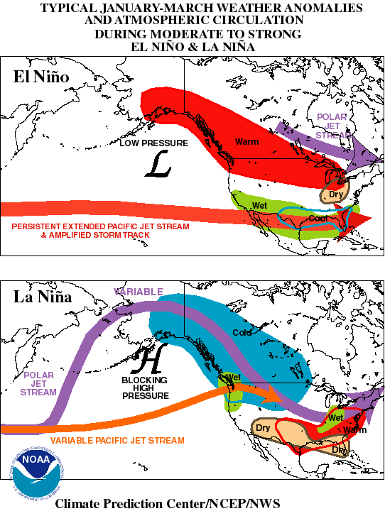
Ntxw wrote:Truly amazing how quickly the ocean can change. From quite an el nino last winter to a complete 180 strong la nina! It's interesting what NY NJ PA Weather mentioned about positive and negative PDO. I've only heard JB mention this a few times from which I learned about. Sometimes we forget to include these warm/cold periods into the predictions. It'll be interesting to see how it pans out. It's a pity we don't have satellite and extensive data prior to the 50s and 60s to use as detailed analogs.

Could this Nina along with the negative PDO finally bring down the stretch of above temperatures worldwide? Got a hunch it might this winter.


And there in lies the question with the negative PDO. The last time we had a -PDO pattern, we had no where near the observational data we have under a +PDO phase. In fact, roughly 90% of the data we have people running around comparing is under a +PDO regime, which is exactly why I have doubts with the very warm anomalies in the Northeast and Northern Mid Atlantic. A -PDO phase typically produces a lower heights anomaly around the Aleutian Islands and a very large ridge in the Gulf of Alaska, which CAN produce a negative EPO pattern. Now, all of this does not work on it's own.

What I mean is that we have to piece everything together. Instead of studying analogs that frankly poorly match what is going on now in terms of solar influences, PDO state, intensity of ENSO state, change in AMO; we have to study how these features are interacting with each other over the next 30 to 45 days, adjust for changes in wave lengths, take into account the stratospheric potential, and go from there. NOT easy. Not easy at all.

Give the uncertainty, this year I would rate the volatility threat of this winters forecast overall to be VERY HIGH.
0 likes   
Let the Water Vapor Satellite lead the way!

User avatar
Portastorm
Storm2k Moderator
Storm2k Moderator
Posts: 9787
Age: 61
Joined: Fri Jul 11, 2003 9:16 am
Location: South Austin, TX
Contact:

Re: Winter 2010-11 for the Southern Plains

#35 Postby Portastorm » Tue Sep 14, 2010 12:54 pm

BTW nynjpa ... welcome to Storm2K! I am glad you're here and know you will add a lot of substance to our forum. Heck, you already have!
0 likes   

NY NJ PA Weather
Professional-Met
Professional-Met
Posts: 22
Age: 44
Joined: Fri Sep 10, 2010 9:39 am
Location: Freehold, New Jersey
Contact:

Re: Winter 2010-11 for the Southern Plains

#36 Postby NY NJ PA Weather » Tue Sep 14, 2010 1:23 pm

Portastorm wrote:BTW nynjpa ... welcome to Storm2K! I am glad you're here and know you will add a lot of substance to our forum. Heck, you already have!


Thanks! Happy to be here. I just sent my prof of Meteorology degree so should have that tag soon. :-)
0 likes   
Let the Water Vapor Satellite lead the way!

User avatar
Tireman4
S2K Supporter
S2K Supporter
Posts: 5674
Age: 58
Joined: Fri Jun 30, 2006 1:08 pm
Location: Humble, Texas
Contact:

Re: Winter 2010-11 for the Southern Plains

#37 Postby Tireman4 » Tue Sep 14, 2010 1:28 pm

NY NJ PA Weather wrote:
Portastorm wrote:BTW nynjpa ... welcome to Storm2K! I am glad you're here and know you will add a lot of substance to our forum. Heck, you already have!


Thanks! Happy to be here. I just sent my prof of Meteorology degree so should have that tag soon. :-)


Woo Hoo, another pro met...:)
0 likes   

HockeyTx82
S2K Supporter
S2K Supporter
Posts: 2034
Joined: Tue Oct 27, 2009 11:17 am
Location: Ponder, TX

Re: Winter 2010-11 for the Southern Plains

#38 Postby HockeyTx82 » Tue Sep 14, 2010 1:58 pm

Hey guys, I have been checking in over the summer. Glad to see the Winter fourum is starting to get moving. So with the water temps and possible strong La Nina, if I am reading what you all have said, what does that mean for the Southern Plains this winter? Is it to soon to start making a forecast? I am so tired of this heat and want the cold and snow. :froze: Either way I am looking forward to another winter with you all.
0 likes   
Don't hold me accountable for anything I post on this forum. Leave the real forecasting up to the professionals.

Location: Ponder, TX (all observation posts are this location unless otherwise noted)

Ntxw
Storm2k Moderator
Storm2k Moderator
Posts: 21554
Joined: Wed Oct 21, 2009 6:34 pm
Location: DFW, Texas

#39 Postby Ntxw » Tue Sep 14, 2010 3:14 pm

Welcome aboard NY NJ PA Weather and looking forward to your pro input this winter!

As for hockey's question, the safe answer right now (as always is for a la nina winter) is that it will be a warm and dry winter with variation for the southern plains. Typically you can have warm days followed by blasting cold fronts for a day or two then back to normal regime vs the constant cool last winter. But of course there's many different factors that come into play. Weather patterns in October have tendency to hint at what's to come for winter.

Northwest Canada/Alaska should be very cold this year which generally is our cold air source, so when something does breakout, could be a doozy for the time it stays. I'd put some money on shallow domes of cold against the deep air masses we saw last year :wink:
0 likes   
The above post and any post by Ntxw is NOT an official forecast and should not be used as such. It is just the opinion of the poster and may or may not be backed by sound meteorological data. It is NOT endorsed by any professional institution including Storm2k. For official information, please refer to NWS products.


  Help support Storm2K!

Help Support Storm2K


User avatar
srainhoutx
S2K Supporter
S2K Supporter
Posts: 6919
Age: 66
Joined: Sun Jan 14, 2007 11:34 am
Location: Haywood County, NC
Contact:

Re: Winter 2010-11 for the Southern Plains

#40 Postby srainhoutx » Tue Sep 14, 2010 4:09 pm

Welcome NY NJ PA Weather! We have a great group of folks and some lively Winter Weather discussions as well. Looking forward to your input.
0 likes   
Carla/Alicia/Jerry(In The Eye)/Michelle/Charley/Ivan/Dennis/Katrina/Rita/Wilma/Ike/Harvey

Member: National Weather Association
Wx Infinity Forums
http://wxinfinity.com/index.php

Facebook.com/WeatherInfinity
Twitter @WeatherInfinity


Return to “Winter Weather”

Who is online

Users browsing this forum: No registered users and 7 guests