

Has been coming down about an inch an hour here since 8:00. Have about 4.5 inches here already downtown. NAM and GFS both pain between .5 to .75 inches of QPF left. i think its a little fluffier than I expected so I could see that panning out to another 8-10 inches which if no melting occured would satisfy the 12 inch prediction easily. We will just have to see. Both have the best dynamics around daybreak. Meanwhile, was riding around tonight and roads are worse now than they ever were during just about the whole 48 event 2 weeks ago. Temp is 30 and its getting heavy at night which should allow good bit of road accumulation. Saw a couple cars slide through an intersection on colfax...narrowly avoided disaster
Update at 11:00...just did an actaul measurement...have 8 inches already on the grass. the concrete is where I measured the 4.5 earlier and its still just about 5-6. Coming down heavy here too.
The Official 2009-2010 Denver winter weather thread
Moderator: S2k Moderators
Forum rules
 The posts in this forum are NOT official forecast and should not be used as such. They are just the opinion of the poster and may or may not be backed by sound meteorological data. They are NOT endorsed by any professional institution or STORM2K.

The posts in this forum are NOT official forecast and should not be used as such. They are just the opinion of the poster and may or may not be backed by sound meteorological data. They are NOT endorsed by any professional institution or STORM2K.
Re: The Official 2009-2010 Denver winter weather thread
Last edited by PTPatrick on Sun Nov 15, 2009 1:06 am, edited 1 time in total.
0 likes

Yep, it only took about an hour or so for the heavy snowfall to start dusting the roads, and once that happened, the roads are getting hammered. Worse now than at any point during our last snowstorm.
I've got 5-6" right now and it's really starting to come down. Even seeing some yellows on the radar. I can't explain it well, but this storm looks completely different than the last one. Maybe it has to do with more snow on the streets. Should be interesting when I wake up tomorrow.
I've got 5-6" right now and it's really starting to come down. Even seeing some yellows on the radar. I can't explain it well, but this storm looks completely different than the last one. Maybe it has to do with more snow on the streets. Should be interesting when I wake up tomorrow.
0 likes
Re: The Official 2009-2010 Denver winter weather thread
As of about 7:00 AM I've got a foot on the grass. There is still some compaction and melting I think like that last storm and the concrete doesnt have quite as much. STorms breakin up and supposed to only get about 2-4 more today. Seems like it hit faster than they thought.
0 likes


Re: The Official 2009-2010 Denver winter weather thread
Seems like amounts coming in arent quite as high as I expected and suprisingly parts of the metro did better than some foothill locations and even castle rock which only reporting 5 inches as of 9:30. I know the foot that I measured at 6:00 this morning was probably not truly representative of the snow laying around because it was on grass which can add a couple inches of height, but 10 inches is probaby pretty accurate and comparing to the areas around me that seems pretty reasonable. I think much of the snow fell during more of a CSI band that was oriented SW to NE from about Bailey through Littleton and up toward NE Denver around 10-12 last night. At that point on radar the band didnt seem to move much and there didnt seem to be as much falling in SE aurora. Obviously at some point the NW parts of the metro caught up though because Westminster and Boulder came out about the same as Denver and Littleton with 8-10 inches. Not a bad storm.
In the meantime, looking ahead to next week we should getting some ridging and warm up up to 50s just in time for it cool off and probably snow again around thanksgiving week. I dont see any 60s in the foreseeable future. I think this storms snow may stick around a little longer than 2 weeks ago(remember we got into the upper 70s a few days later). Some long range models are pointing at some arctic dumps of air in the late period near Thanksgiving toward first week of December. Something to watch for. So far winter is shaping up nicely. Here at my house I at 32 inches of accumulation for the season and its not even winter yet. Thats about half of the snow we should get in a year.
In the meantime, looking ahead to next week we should getting some ridging and warm up up to 50s just in time for it cool off and probably snow again around thanksgiving week. I dont see any 60s in the foreseeable future. I think this storms snow may stick around a little longer than 2 weeks ago(remember we got into the upper 70s a few days later). Some long range models are pointing at some arctic dumps of air in the late period near Thanksgiving toward first week of December. Something to watch for. So far winter is shaping up nicely. Here at my house I at 32 inches of accumulation for the season and its not even winter yet. Thats about half of the snow we should get in a year.
Last edited by PTPatrick on Sun Nov 15, 2009 6:21 pm, edited 1 time in total.
0 likes
-
VoodooCadillac
- Tropical Depression

- Posts: 82
- Joined: Wed Dec 14, 2005 8:56 pm
- Location: Fort Collins, Colorado
Re: The Official 2009-2010 Denver winter weather thread
6.5" in FC this AM. Cleared early - beautiful day.
YTD snow here:
First storm - 3"
Big storm - 21.5"
Today - 6.5"
Total = 31"
YTD snow here:
First storm - 3"
Big storm - 21.5"
Today - 6.5"
Total = 31"
0 likes
I measured 12" on my patio table. Driveway only got up to 8", so shoveling wasn't that bad. You can check out the totals from below.
http://www.crh.noaa.gov/product.php?sit ... suedby=BOU
http://www.crh.noaa.gov/product.php?sit ... suedby=BOU
0 likes
-
srainhoutx

- S2K Supporter

- Posts: 6919
- Age: 66
- Joined: Sun Jan 14, 2007 11:34 am
- Location: Haywood County, NC
- Contact:
Re: The Official 2009-2010 Denver winter weather thread
Congrats folks. If guidance is correct, you'll be adding to your totals this coming weekend. 
0 likes
Carla/Alicia/Jerry(In The Eye)/Michelle/Charley/Ivan/Dennis/Katrina/Rita/Wilma/Ike/Harvey
Member: National Weather Association
Wx Infinity Forums
http://wxinfinity.com/index.php
Facebook.com/WeatherInfinity
Twitter @WeatherInfinity
Member: National Weather Association
Wx Infinity Forums
http://wxinfinity.com/index.php
Facebook.com/WeatherInfinity
Twitter @WeatherInfinity
Re: The Official 2009-2010 Denver winter weather thread
Just to put things in perspective, last year DIA reported 12" of snow from July1st until the end of the year. Already way ahead of that!
PUBLIC INFORMATION STATEMENT...CORRECTION FOR EVERGREEN...
NATIONAL WEATHER SERVICE DENVER CO
1010 AM MST MON NOV 16 2009
...DENVER METRO AREA SNOWFALL REPORTS...
NOTE: ALL REPORTS ARE IN INCHES
NOTE: T = TRACE (LESS THAN 0.1 INCH)
NOTE: 24 HOUR SNOWFALL AMOUNTS
SNOWFALL SNOWFALL SNOWFALL
24 HOUR TOTAL MONTHLY TOTAL SEASONAL TOTAL
(NOVEMBER) (7/1/09-6/30/10)
DENVER INTL AIRPORT 0.5 9.3 26.5
THROUGH 6AM
DENVER-STAPLETON 0.6 6.6 15.6
THROUGH 6AM
DENVER CITY PARK 3.0 7.7 23.7
THROUGH MIDNIGHT
EVERGREEN 0.0 8.7 42.6
THROUGH 8AM
NORTH LONGMONT TRACE 7.6 23.7
THROUGH 8AM
RALSTON RESERVOIR 1.0 8.0 37.0
THROUGH 8AM
WHEAT RIDGE 0.9 10.9 39.3
THROUGH 7AM
0 likes
-
VoodooCadillac
- Tropical Depression
- Posts: 82
- Joined: Wed Dec 14, 2005 8:56 pm
- Location: Fort Collins, Colorado
Re: The Official 2009-2010 Denver winter weather thread
Looking at some of the models - our next action looks to be Sunday and Wednesday of next week.
0 likes
Re: The Official 2009-2010 Denver winter weather thread
This pattern change is crap! 60's over Turkey day.. Boooooo. 
0 likes
Re: The Official 2009-2010 Denver winter weather thread
I agree SCM. I have yet to experience a white thanksgiving here in Colorado. Have had 2 white Halloweens and 2 white Christmas's. I think 2 years ago there was little snow on the ground for thanksgiving, but actual thanksgiving day was warm and most of it melted early in the morning. My first thanksgiving here in 06 was warm enough to have dinner on the patio. Craziness...anywho...looks like pattern should flip back with some possible arctic intrustion down the middle of the country in the post thanksgiving weekend into the first week of Decemeber. Cant wait 
0 likes
Re: The Official 2009-2010 Denver winter weather thread
Long range GFS is continuing to look quite cold and snowy for much of the country's midsection including Colorado. If its right a week from today give or take a day we should get a front, and then another front and basically temps bottoming out during the 10-12 day part of the forecast with a 510 decimeter arctic airmass sitting smack over Colorado. This would probably give Denver some below zero readings if it really turned out this way. that isnt too far fetched either as my only really below zero temps last winter occurred with that blue northern system an the second week of December. Dont recall exactly but I got well into the teens below zero even here in downtown. It also shows most of Texas in the deep freeze with winter weather in central and northern texas. Denver would have snow on and off with different systems that entire week also...CANT WAIT!
Afternoon edit: 12z an 18z flip flopped a bit and not lloking "as cold" or snowy. Suffice it say in that time frame there will be some big run to inconsistencies. I do think its only a matter of time though before a pattern change will have to happen again. 12z Euro swings a cut off low through the desert southwest this time next weekend...looks too far south to do much for us other than bring down cooler area. Then it shows a bigger trough at about 10 days with a fairly good looking storm. I hate model watching 10 days out, but the way things are lately not much else to do :-/
Afternoon edit: 12z an 18z flip flopped a bit and not lloking "as cold" or snowy. Suffice it say in that time frame there will be some big run to inconsistencies. I do think its only a matter of time though before a pattern change will have to happen again. 12z Euro swings a cut off low through the desert southwest this time next weekend...looks too far south to do much for us other than bring down cooler area. Then it shows a bigger trough at about 10 days with a fairly good looking storm. I hate model watching 10 days out, but the way things are lately not much else to do :-/
0 likes
-
VoodooCadillac
- Tropical Depression
- Posts: 82
- Joined: Wed Dec 14, 2005 8:56 pm
- Location: Fort Collins, Colorado
Re: The Official 2009-2010 Denver winter weather thread
When it comes to reading these models - I'll be the first to admit I'm a layman. But, to this layman, it certainly appears to turn decisively colder beginning Thanksgiving weekend - and staying that way for awhile.
0 likes
Re: The Official 2009-2010 Denver winter weather thread
GFS not looking near as cold as it had been. Should still see a shot of snow this weekend but not a storm. Next week appears unsettled and models dont really seem to know where to go with it. Should be decidedly colder in the sat night to MOnday time frame, then slightly warmed tuesday, then colder...but I dont see much precip for now.
0 likes
Re: The Official 2009-2010 Denver winter weather thread
IMHO...this is probably pretty normal. This is so far a fairly puny el nino so I wouldnt expect the most extreme el nino effects to take place over the US. And even for an el nino year we are often warmer than normal with just average precip. Some el ninos really have left us high and dry. October and early november were very typical for el nino effects for this area. I would agree that though that the parade of storms through the NW is unusual for El nino... I suspect as el nino strengthens a bit more through winter we may see the mean storm track shift a little further south through California.
My first thanksgiving here was like this...60s and dry as a bone...in fact that was 2006 an el nino had just gotten going in november and december. We stayed fairly warm and dry for the first half of December...then wham, storm after storm for about 6 weeks. Patterns eb and flow. Its sucks. And some years you cant break out last year we were under the ridge of death from about Christmas to March. If you had asked me in February if we were heading toward one of the wettest Denver years ever, I would have said crazy. We have had so much snow and moisture this year so far I hate to piss off the snow gods by complaining. Having said that...if I was a skier I might be complaining. The resorts really havent done so hot since those initial couple storms back in October. I think Denver metro may have had more snow than Vail this fall.
My first thanksgiving here was like this...60s and dry as a bone...in fact that was 2006 an el nino had just gotten going in november and december. We stayed fairly warm and dry for the first half of December...then wham, storm after storm for about 6 weeks. Patterns eb and flow. Its sucks. And some years you cant break out last year we were under the ridge of death from about Christmas to March. If you had asked me in February if we were heading toward one of the wettest Denver years ever, I would have said crazy. We have had so much snow and moisture this year so far I hate to piss off the snow gods by complaining. Having said that...if I was a skier I might be complaining. The resorts really havent done so hot since those initial couple storms back in October. I think Denver metro may have had more snow than Vail this fall.
0 likes
-
Scott Patterson
- Category 2

- Posts: 796
- Age: 49
- Joined: Wed Mar 22, 2006 6:52 pm
- Location: Near Craig Colorado
- Contact:
Re: The Official 2009-2010 Denver winter weather thread
And I would have to say that Denver has likely picked up more snow than many of the ski resorts this year in Colorado.
It's true.
There isn't much snow at many of the ski resorts unless you get up really high.
Anyway, I took this photo yesterday from near the summit of Buckeye Peak at 12,867 feet (north of Leadville):
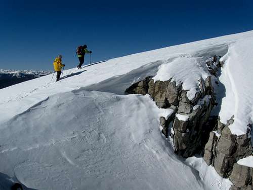
Down at Leadville though (10,200 feet), there wasn't much snow at all.
0 likes
Who is online
Users browsing this forum: No registered users and 13 guests