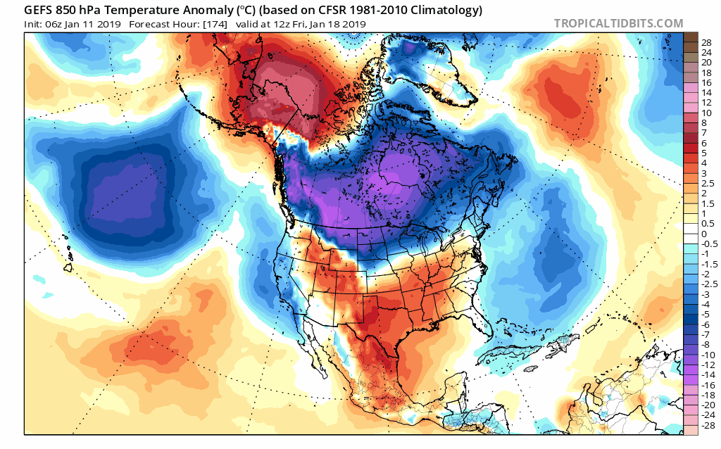
The 00Z GFS North American Hemispheric 500 mb analysis is an image to behold for yours truly, even if it is way out 384 hours. Wow! Impressive ridging U.S.West Coast/Western Canada north to Alaska , impressive ridging across Greenland and the massive PV and upper trough overwhelming most of the continent by the end of this month.
Normally, I do not take much of anything too serious that far out. However, given the fact that the signs of the pattern change are evident now, and agreement is reasonably good within 264 hours already with the reliable models, I think the 384 hour run may not be so far fetched after all folks.
For those who really love the idea of real serious cold air, the pattern carved out on the 384 hour is as close to ideal as you will see it for the continent.
Texas Winter 2018-2019
Moderator: S2k Moderators
Forum rules
 The posts in this forum are NOT official forecast and should not be used as such. They are just the opinion of the poster and may or may not be backed by sound meteorological data. They are NOT endorsed by any professional institution or STORM2K.

The posts in this forum are NOT official forecast and should not be used as such. They are just the opinion of the poster and may or may not be backed by sound meteorological data. They are NOT endorsed by any professional institution or STORM2K.
-
northjaxpro

- S2K Supporter

- Posts: 8900
- Joined: Mon Sep 27, 2010 11:21 am
- Location: Jacksonville, FL
Re: Texas Winter 2018-2019
3 likes
NEVER, EVER SAY NEVER in the tropics and weather in general, and most importantly, with life itself!!
________________________________________________________________________________________
Fay 2008 Beryl 2012 Debby 2012 Colin 2016 Hermine 2016 Julia 2016 Matthew 2016 Irma 2017 Dorian 2019
________________________________________________________________________________________
Fay 2008 Beryl 2012 Debby 2012 Colin 2016 Hermine 2016 Julia 2016 Matthew 2016 Irma 2017 Dorian 2019

Re: Texas Winter 2018-2019
northjaxpro wrote:The 00Z GFS North American Hemispheric 500 mb analysis is an image to behold for yours truly, even if it is way out 384 hours. Wow! Impressive ridging U.S.West Coast/Western Canada north to Alaska , impressive ridging across Greenland and the massive PV and upper trough overwhelming most of the continent by the end of this month.
Normally, I do not take much of anything too serious that far out. However, given the fact that the signs of the pattern change are evident now, and agreement is reasonably good within 264 hours already with the reliable models, I think the 384 hour run may not be so far fetched after all folks.
For those who really love the idea of real serious cold air, the pattern carved out on the 384 hour is as close to ideal as you will see it for the continent.
Sounds good. Now, will there be a moisture feed as well?
0 likes
-
northjaxpro
- S2K Supporter
- Posts: 8900
- Joined: Mon Sep 27, 2010 11:21 am
- Location: Jacksonville, FL
Re: Texas Winter 2018-2019
1 likes
NEVER, EVER SAY NEVER in the tropics and weather in general, and most importantly, with life itself!!
________________________________________________________________________________________
Fay 2008 Beryl 2012 Debby 2012 Colin 2016 Hermine 2016 Julia 2016 Matthew 2016 Irma 2017 Dorian 2019
________________________________________________________________________________________
Fay 2008 Beryl 2012 Debby 2012 Colin 2016 Hermine 2016 Julia 2016 Matthew 2016 Irma 2017 Dorian 2019
Re: Texas Winter 2018-2019
FV3 GFS not impressive. Canada is loaded with arctic air, but it doesn't get transported south.
0 likes
Re: Texas Winter 2018-2019
harp wrote:FV3 GFS not impressive. Canada is loaded with arctic air, but it doesn't get transported south.
It’s been doing that for a while now. Staying locked up north.
1 likes
-
gboudx

- S2K Supporter
- Posts: 4047
- Joined: Thu Sep 04, 2003 1:39 pm
- Location: Rockwall, Tx but from Harvey, La
Re: Texas Winter 2018-2019
Brent wrote:harp wrote:dhweather wrote:Interesting.
https://www.tropicaltidbits.com/analysis/models/gfs/2019011100/gfs_z500_mslp_nhem_35.png
Can you interpret this please?
taking it at face value just a cold front for most of us, snow is pretty far north
Maybe he’s referring to the Cat 3 low pressure bearing down on Canada.
1 likes

Re: Texas Winter 2018-2019
Cpv17 wrote:harp wrote:FV3 GFS not impressive. Canada is loaded with arctic air, but it doesn't get transported south.
It’s been doing that for a while now. Staying locked up north.
Yes the coldest air on Earth is sitting over Canada/North America and not Asia/Europe. Shows the SSW worked. Now lets see if consequent model runs delivers the cold air.
3 likes
The above post and any post by Ntxw is NOT an official forecast and should not be used as such. It is just the opinion of the poster and may or may not be backed by sound meteorological data. It is NOT endorsed by any professional institution including Storm2k. For official information, please refer to NWS products.
Help support Storm2K!

Re: Texas Winter 2018-2019
harp wrote:dhweather wrote:Interesting.
https://www.tropicaltidbits.com/analysis/models/gfs/2019011100/gfs_z500_mslp_nhem_35.png
Can you interpret this please?
Cat 3 in the gulf, of Alaska.
But what I'm referring to is that Canada appears to be getting loaded with cold air. The million dollar question is will something transport it south, or will wxman57's wall hold. PV dropping into the Hudson Bay, signs of the already discussed cross polar flow.
All said, it's over 5 days out, so it is a suggestion at best.
0 likes
The above post and any post by dhweather is NOT an official forecast and should not be used as such. It is just the opinion of the poster and may or may not be backed by sound meteorological data. It is NOT endorsed by any professional institution including storm2k.org. For official information, please refer to NWS products.
-
TeamPlayersBlue

- Category 5

- Posts: 3310
- Joined: Tue Feb 02, 2010 1:44 am
- Location: Denver/Applewood, CO
Re: Texas Winter 2018-2019
Well, the GFS for the last 24 hours or so has been consistent in the long range. Doesnt mean it will happen, but its good that it's consistent. Like i mentioned yesterday though, the PV is positioned well for an arctic plunge not too far out. So, once the PV is positioned well, the rest should follow if it remains in place. I think by monday we can determine if we can take the models more seriously.
0 likes
Personal Forecast Disclaimer:
The posts in this forum are NOT official forecast and should not be used as such. They are just the opinion of the poster and may or may not be backed by sound meteorological data. They are NOT endorsed by any professional institution or storm2k.org. For official information, please refer to the NHC and NWS products.
The posts in this forum are NOT official forecast and should not be used as such. They are just the opinion of the poster and may or may not be backed by sound meteorological data. They are NOT endorsed by any professional institution or storm2k.org. For official information, please refer to the NHC and NWS products.
-
wxman57

- Moderator-Pro Met

- Posts: 22484
- Age: 66
- Joined: Sat Jun 21, 2003 8:06 pm
- Location: Houston, TX (southwest)
Re: Texas Winter 2018-2019
Yes, the GFS has been consistent in the long range - consistently bad. Meanwhile, my wall along the Canadian border is growing taller by the day.
0 likes
Re: Texas Winter 2018-2019
wxman57 wrote:Yes, the GFS has been consistent in the long range - consistently bad. Meanwhile, my wall along the Canadian border is growing taller by the day.
For the sake of World Peace I say to you, Mr. Heat Miser..
"Tear down this wall!"
2 likes
The above post and any post by Ntxw is NOT an official forecast and should not be used as such. It is just the opinion of the poster and may or may not be backed by sound meteorological data. It is NOT endorsed by any professional institution including Storm2k. For official information, please refer to NWS products.
Help support Storm2K!
Help support Storm2K!
-
TeamPlayersBlue
- Category 5
- Posts: 3310
- Joined: Tue Feb 02, 2010 1:44 am
- Location: Denver/Applewood, CO
Re: Texas Winter 2018-2019
Ntxw wrote:wxman57 wrote:Yes, the GFS has been consistent in the long range - consistently bad. Meanwhile, my wall along the Canadian border is growing taller by the day.
For the sake of World Peace I say to you, Mr. Heat Miser..
"Tear down this wall!"
https://images2.imgbox.com/b9/74/wj7Xn%20nGh_o.gif
Oh its coming down, or heads will roll!
In all seriousness, 384 GFS is always a joke.... EXCEPT THIS TIME.
2 likes
Personal Forecast Disclaimer:
The posts in this forum are NOT official forecast and should not be used as such. They are just the opinion of the poster and may or may not be backed by sound meteorological data. They are NOT endorsed by any professional institution or storm2k.org. For official information, please refer to the NHC and NWS products.
The posts in this forum are NOT official forecast and should not be used as such. They are just the opinion of the poster and may or may not be backed by sound meteorological data. They are NOT endorsed by any professional institution or storm2k.org. For official information, please refer to the NHC and NWS products.
-
orangeblood
- S2K Supporter
- Posts: 3334
- Joined: Tue Dec 15, 2009 6:14 pm
- Location: Fort Worth, TX
Re: Texas Winter 2018-2019
We’re in record SSW territory at the prime time of year with the main daughter vortex setting up shop over Hudson Bay....It appears something special is brewing!!
https://mobile.twitter.com/Forecas55175638/status/1083639937315016704
https://mobile.twitter.com/Forecas55175638/status/1083639937315016704
3 likes
Re: Texas Winter 2018-2019
orangeblood wrote:We’re in record SSW territory at the prime time of year with the main daughter vortex setting up shop over Hudson Bay....It appears something special is brewing!!
https://mobile.twitter.com/Forecas55175638/status/1083639937315016704
A similar SSW in 2004 yielded a fairly chilly Feb! (monthly temps similar to Feb 2015) and a 3"/Valentines day snowfall at DFW (winter of 2003-2004).
1 likes
The above post and any post by Ntxw is NOT an official forecast and should not be used as such. It is just the opinion of the poster and may or may not be backed by sound meteorological data. It is NOT endorsed by any professional institution including Storm2k. For official information, please refer to NWS products.
Help support Storm2K!
Help support Storm2K!
-
bubba hotep

- S2K Supporter
- Posts: 5533
- Joined: Wed Dec 28, 2016 1:00 am
- Location: Collin County Texas
Re: Texas Winter 2018-2019
One of the things to watch closely, is where does the high lat blocking setup? The Pacific evolution certainly favors split flow in the longer range but if we get a -EPO/+PNA then we will get stuck in the dreaded NW Flow and that is what the 00z GEFS is showing. Based on the Pacific, I think something like late Feb into early March '15 is in the cards but we need the ridging to setup with more of a relaxed PNA look. Also, we need the PVL to stay up in Canada, if it sets up shop farther south towards the GL then it will be very hard for systems to amp up as they come out of the SW. There are a lot of moving parts but I didn't really like the 00z GEFS look, dry cold sucks.

3 likes
Winter time post are almost exclusively focused on the DFW area.
-
Toadfrog
- Tropical Low

- Posts: 13
- Age: 58
- Joined: Tue Dec 19, 2017 4:52 pm
- Location: Round Rock, Texas
Re: Texas Winter 2018-2019
Considering the cold bottled up in Canada, it will need to break loose in time. I just have that feeling in me ol' bones that Texas will get a bite of it soon. Bring it......I don't want to mow my grass in January.
0 likes
-
wxman57
- Moderator-Pro Met
- Posts: 22484
- Age: 66
- Joined: Sat Jun 21, 2003 8:06 pm
- Location: Houston, TX (southwest)
Re: Texas Winter 2018-2019
2 likes
-
bubba hotep
- S2K Supporter
- Posts: 5533
- Joined: Wed Dec 28, 2016 1:00 am
- Location: Collin County Texas
Re: Texas Winter 2018-2019
wxman57 wrote:Snow in NE TX at hour 264. This time it's for real! I buy it!
http://wxman57.com/images/snow.JPG
That has a late February '15 feel to it. The first system for N. Texas to watch is the 19/20th +/- and then we start the temp step down with each additional system having potential, with the right track.
1 likes
Winter time post are almost exclusively focused on the DFW area.
-
bubba hotep
- S2K Supporter
- Posts: 5533
- Joined: Wed Dec 28, 2016 1:00 am
- Location: Collin County Texas
Re: Texas Winter 2018-2019
Once the GEFS opens the gates, they might not close!

5 likes
Winter time post are almost exclusively focused on the DFW area.
Who is online
Users browsing this forum: No registered users and 12 guests