Southern Plains winter wx thread (2009-2010)

Winter Weather Discussion

Moderator: S2k Moderators

Forum rules

The posts in this forum are NOT official forecast and should not be used as such. They are just the opinion of the poster and may or may not be backed by sound meteorological data. They are NOT endorsed by any professional institution or STORM2K.

Help Support Storm2K
Message
Author
User avatar
Extremeweatherguy
Category 5
Category 5
Posts: 11095
Joined: Mon Oct 10, 2005 8:13 pm
Location: Houston, TX

#601 Postby Extremeweatherguy » Sun Feb 21, 2010 12:00 pm

Hmm, the GFS is starting to look even more interesting today. It is now showing two upcoming snow events for Southern Plains (excluding the upcoming Texas storm). The first arrives this Thursday night/Friday morning, and if the GFS is correct, could drop as much as 3-6" of snow on some areas:

Image

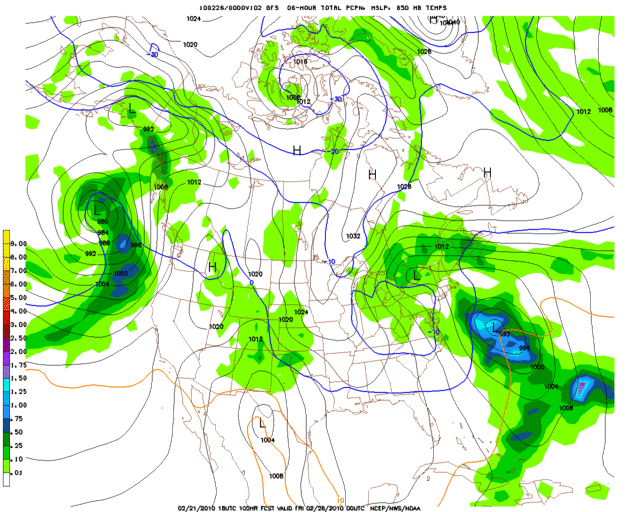
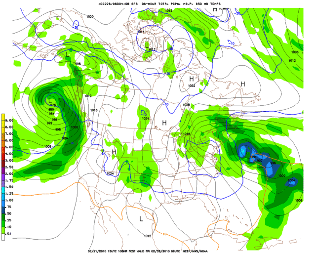
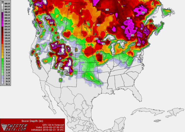
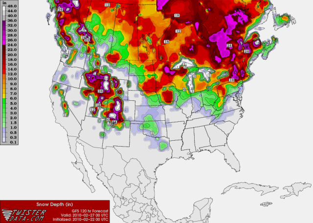
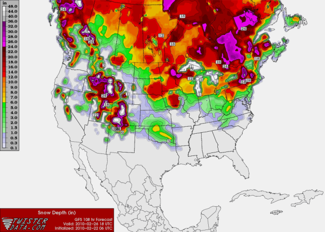
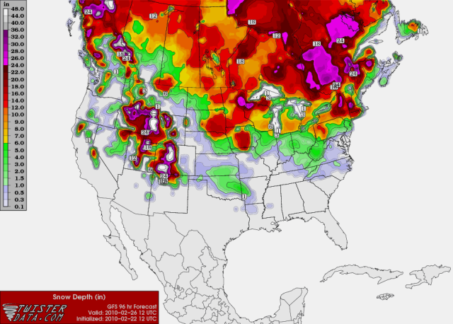
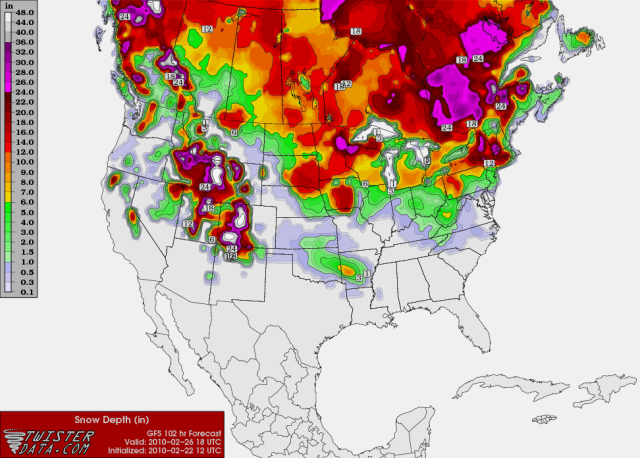
And the second system arrives in about 7-8 days:

Image
Image
0 likes   

User avatar
Extremeweatherguy
Category 5
Category 5
Posts: 11095
Joined: Mon Oct 10, 2005 8:13 pm
Location: Houston, TX

#602 Postby Extremeweatherguy » Sun Feb 21, 2010 12:07 pm

BTW, here is what the Norman NWS had to say about the situation in their 331AM forecast discussion...

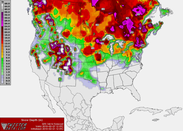
A BRIEF RESPITE TONIGHT INTO MONDAY BEFORE THE FIRST OF WHAT NOW
LOOKS LIKE THREE MORE SYSTEMS APPROACHES MONDAY NIGHT AND TUESDAY.
WE WILL KEEP POPS IN THE W AND S... BUT LATEST TRENDS SUGGEST THIS
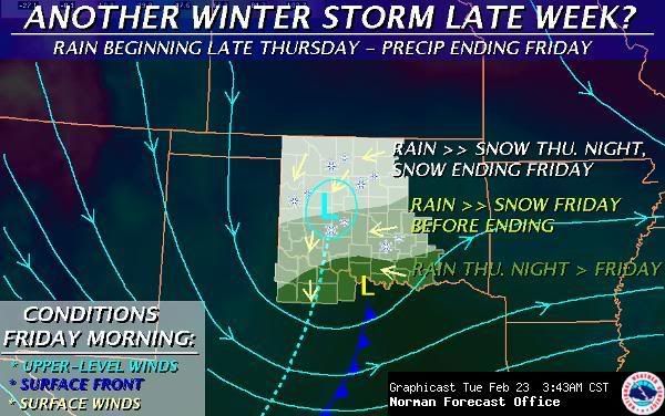
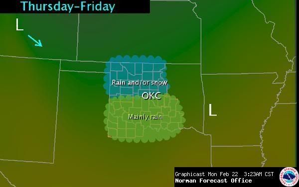
ONE MAY STAY MOSTLY TO OUR S. ANOTHER WAVE SWINGS THROUGH THU-FRI
AND IS STRONGER ON THE LATEST MED-RANGE MODELS. WE WILL SPREAD LOW
POPS AREAWIDE FOR THIS ONE. THE THIRD ONE MAY BE THE WORST OF THE
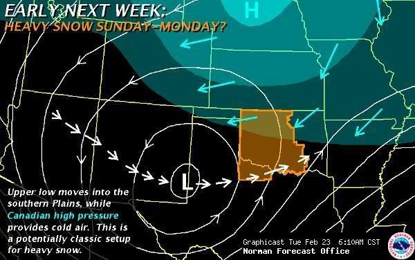
LOT AND SHOULD AFFECT US OVER THE WEEKEND. FOR NOW WE WILL FAVOR THE
DEEPER AND SLOWER ECMWF OVER THE GFS... THUS KEEPING POPS BELOW 20
PCT UNTIL AFTER SATURDAY. BY SUNDAY WE MAY BE LOOKING AT ANOTHER
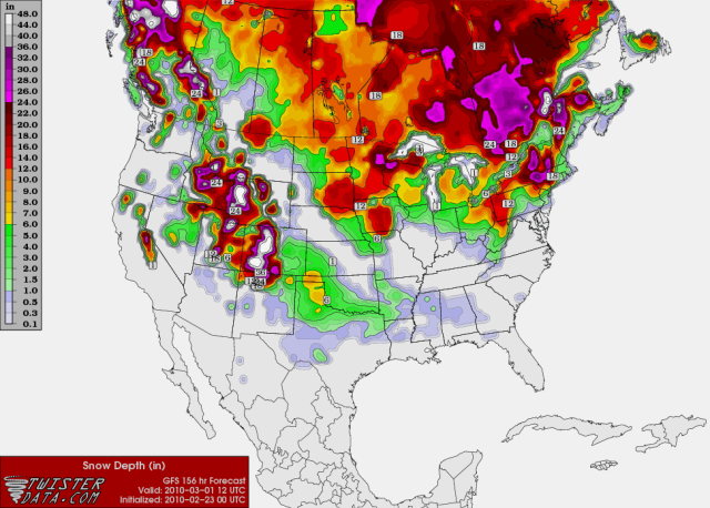
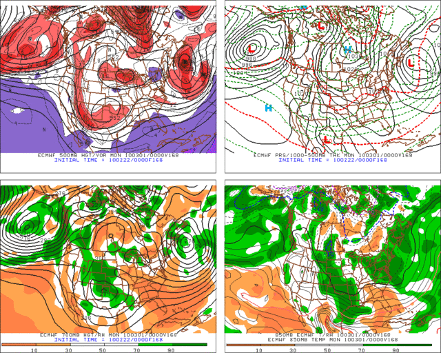
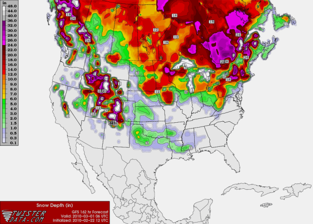
SIGNIFICANT WINTER STORM IN PARTS OF THE AREA IF IT REMAINS COLD
ENOUGH... OR HEAVY RAIN IF IT DOESN`T. OR BOTH. IT SHOULD BE
NOTED THAT THIS ONE APPEARS TO HAVE THE MAKINGS OF ANOTHER MAJOR
WINTER STORM FOR PARTS OF THE EAST DURING THE FIRST WEEK OF MARCH.


It will be interesting to see what they say in their afternoon discussion since the 12z GFS is now looking even more impressive, especially with the Thurs/Fri system.
0 likes   

User avatar
Extremeweatherguy
Category 5
Category 5
Posts: 11095
Joined: Mon Oct 10, 2005 8:13 pm
Location: Houston, TX

#603 Postby Extremeweatherguy » Sun Feb 21, 2010 5:17 pm

The 18z GFS continues to be on board for a potentially significant snowstorm across Oklahoma and extreme north Texas later this week. The NWS offices are not too bullish on this event just yet, but if these model trends continue then I would expect more interest to arise over the next few days..

http://i43.photobucket.com/albums/e371/ ... 102l-1.gif
http://i43.photobucket.com/albums/e371/ ... p_108l.gif
http://i43.photobucket.com/albums/e371/ ... p_114l.gif
http://i43.photobucket.com/albums/e371/ ... p_120l.gif
http://i43.photobucket.com/albums/e371/ ... p_126l.gif

http://i43.photobucket.com/albums/e371/ ... SURFAC.png
Large area of 3-7" snow accumulations across Oklahoma at hour 126
0 likes   

User avatar
Extremeweatherguy
Category 5
Category 5
Posts: 11095
Joined: Mon Oct 10, 2005 8:13 pm
Location: Houston, TX

#604 Postby Extremeweatherguy » Sun Feb 21, 2010 11:25 pm

The 00z GFS is not quite as impressive with the late week event, but it still shows a fairly widespread snowfall on the order of 1-3" (locally 4-5") across Oklahoma and into NE Texas:

snow depth at hour 114: http://i43.photobucket.com/albums/e371/ ... SURFAC.png
snow depth at hour 120: http://i43.photobucket.com/albums/e371/ ... SURFAC.png
snow depth at hour 126: http://i43.photobucket.com/albums/e371/ ... SURFAC.png


BTW - -

In the MUCH shorter term, it is worth noting that we (central Oklahoma) cannot entirely rule out a few snowflakes later tonight or again tomorrow night/Tuesday morning.

The radar loop this evening has been showing some light precipitation moving eastward over the Texas panhandle. If this precipitation can survive to make it here in a few hours, then it would likely fall in the form of snow. Because of this, the NWS has added a chance of flurries to the forecast. As of right now nothing looks like it would be widespread or significant enough for even very light accumulations, but the radar trends will need to be watched closely just in case an area of higher reflectivity emerges.

Tomorrow night will be another time to watch. While the incoming weather system should primarily impact areas west and south of central Oklahoma, it is not entirely impossible that we could see a few light snow bands move through this region too. Both the 00z NAM MOS and 00z GFS MOS are showing 25-35% precipitation chances for both Oklahoma City and Norman during the tomorrow night/Tuesday morning period.
0 likes   

User avatar
Extremeweatherguy
Category 5
Category 5
Posts: 11095
Joined: Mon Oct 10, 2005 8:13 pm
Location: Houston, TX

#605 Postby Extremeweatherguy » Mon Feb 22, 2010 2:38 am

The 00z ECMWF is on board big time for the late week storm and then again for the storm in about 7 days:

FRIDAY EVENING 2/26/10
Image

SUNDAY EVENING 2/28/10
Image
0 likes   

User avatar
Extremeweatherguy
Category 5
Category 5
Posts: 11095
Joined: Mon Oct 10, 2005 8:13 pm
Location: Houston, TX

#606 Postby Extremeweatherguy » Mon Feb 22, 2010 8:27 am

Well i'm not quite sure where this Norman NWS graphic came from:

http://i43.photobucket.com/albums/e371/ ... utlook.jpg

:?:

It doesn't match up at all with what the GFS or ECMWF are showing, both of which have a significant winter storm impacting most of the state...and not just a rain/snow mix over the northern half.

The 6z GFS, in fact, is back to showing 6"+ accumulations in some places:

http://i43.photobucket.com/albums/e371/ ... SURFAC.png

I guess the NWS is just being conservative right now. If the models keep up though, then i'm sure their graphics will become a little more bullish in the days to come.

I will say though, that the NWS is surprisingly a little more bullish on the system that is going to be following this one. Here is what they had to say in their morning discussion..

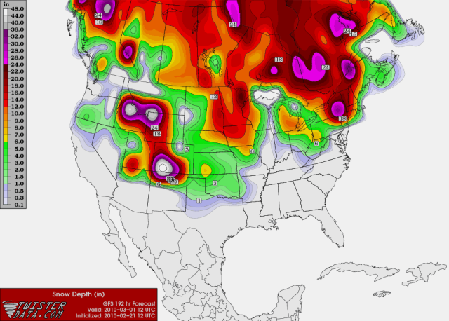
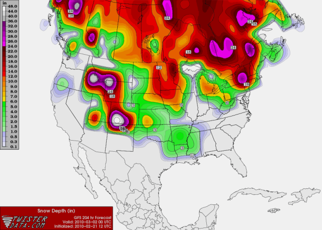
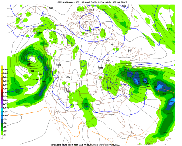
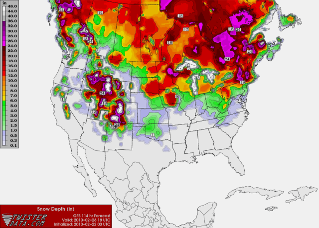
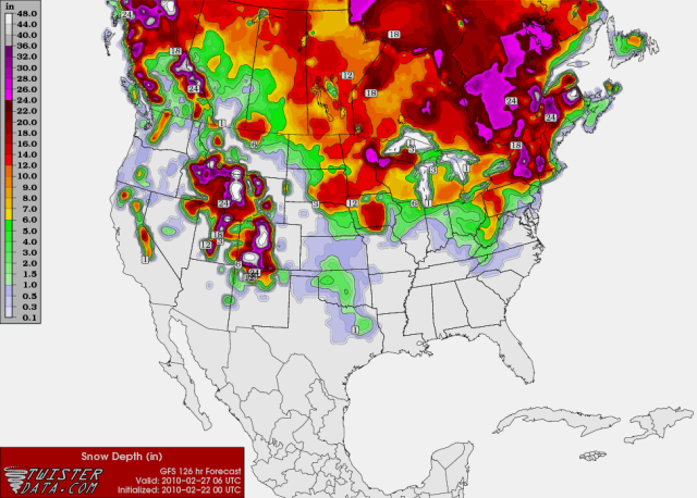
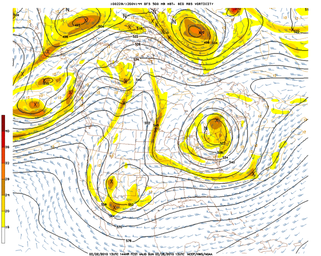
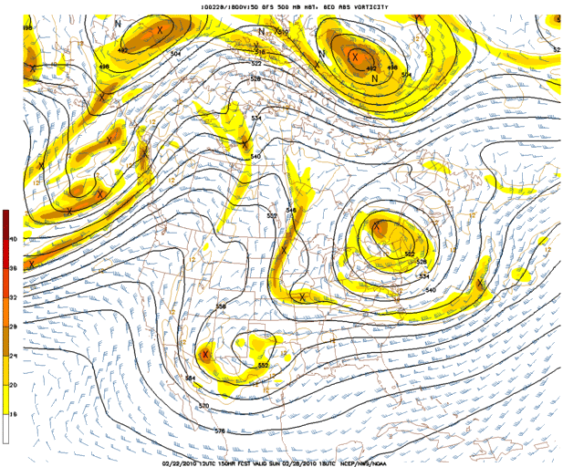
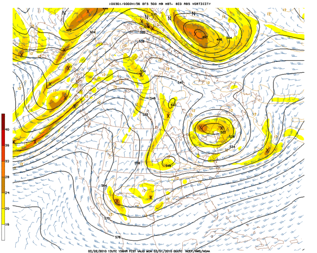
THIRD SYSTEM ARRIVES LATE WEEKEND INTO EARLY NEXT WEEK. ONCE AGAIN
IT LOOKS LIKE A RACE BETWEEN THE BEST LIFT AND THE COOLER AIR...
AND THE QUESTION IS WHETHER THEY WILL JUXTAPOSE. THIS TIME IT
LOOKS LIKE THE COLD AIR EVENTUALLY WILL ARRIVE IN TIME FOR A
CHANGEOVER... AND THUS A BETTER CHANCE OF SNOW.
WE WILL RUN CHANCE
POPS ALL AREAS SUNDAY-MONDAY AND GO WITH RAIN OR SNOW ACROSS MOST
OF CENTRAL/N OK AFTER SUNDAY. ECMWF DEPICTS AN EVOLUTION WITH SOME
CLASSIC CHARACTERISTICS OF HEAVY SNOW EVENTS IN OK. STILL A LONG
WAY OUT... BUT ONE WEEK FROM TODAY IS MARCH 1 AND SO MARCH MADNESS
COULD BEGIN IN CLASSIC FORM.


..It seems like, ATM, they think this third system (the one in ~6 to 8 days) has more potential to be a big deal.
Last edited by Extremeweatherguy on Mon Feb 22, 2010 8:45 am, edited 4 times in total.
0 likes   

Peanut432
Tropical Storm
Tropical Storm
Posts: 119
Joined: Mon Jan 25, 2010 10:21 pm
Location: Hollis Ok

Re: Southern Plains winter wx thread (2009-2010)

#607 Postby Peanut432 » Mon Feb 22, 2010 8:34 am

Way to bring the thread back. Great info and thanks ewg
0 likes   

User avatar
somethingfunny
ChatStaff
ChatStaff
Posts: 3926
Age: 35
Joined: Thu May 31, 2007 10:30 pm
Location: McKinney, Texas

#608 Postby somethingfunny » Mon Feb 22, 2010 11:03 am

This has been the most absurd winter.
0 likes   

User avatar
Extremeweatherguy
Category 5
Category 5
Posts: 11095
Joined: Mon Oct 10, 2005 8:13 pm
Location: Houston, TX

#609 Postby Extremeweatherguy » Mon Feb 22, 2010 11:16 am

The 12z GFS is once again looking a little less impressive for the late week snow event, but still shows widespread accumulations across the southern plains:

96 hrs - http://i43.photobucket.com/albums/e371/ ... URFACE.png
102 hrs - http://i43.photobucket.com/albums/e371/ ... SURFAC.png

The "big event" might be what's coming later though. As I have noted in previous posts, and as the NWS pointed out this morning, the system coming Sunday into Monday could be a much bigger deal. Here is a look at what the 12z GFS is showing as of right now:

500mb 144 hrs - http://i43.photobucket.com/albums/e371/ ... 0_144l.gif
500mb 150 hrs - http://i43.photobucket.com/albums/e371/ ... 0_150l.gif
500mb 156 hrs - http://i43.photobucket.com/albums/e371/ ... 0_156l.gif

156 hr snow accum. - http://i43.photobucket.com/albums/e371/ ... SURFAC.png
162 hr snow accum. - http://i43.photobucket.com/albums/e371/ ... SURFAC.png

I think it is very possible that the latest GFS could be under-doing snow amounts across the southern plains with this system, but we still have several runs for that to be worked out. Overall, the main idea to take away right now is that a widespread (and potentially major) winter storm is *possible* in about 6-7 days.
0 likes   

msstateguy83

#610 Postby msstateguy83 » Mon Feb 22, 2010 3:48 pm

IMO this upcoming event for the wkend might border line on extreme looks like it could be a VERY VERY BIG SNOW
STORM from NW TX UP INTO OK..... needs to be watched very closely in the days ahead...


EDIT: lets also keep a close eye on this event later in the week also it COULD still be something MAJOR, looked bigger
in earlyer runs not as strong now but that dont mean anything still could change back in coming days so i wouldnt
count the friday event out just yet...
0 likes   

Ntxw
Storm2k Moderator
Storm2k Moderator
Posts: 21523
Joined: Wed Oct 21, 2009 6:34 pm
Location: DFW, Texas

#611 Postby Ntxw » Mon Feb 22, 2010 5:29 pm

The models have recently decided to open up this low. If it does there's still the potential for heavy snowfall just not as likely away from the forming coastal trough, but if for some reason they are underestimating it and it decides to keep a cut off low throwing back copious amounts of moisture, there's a real potential for a major storm from the southern plains through the deep south up into northeast.
0 likes   
The above post and any post by Ntxw is NOT an official forecast and should not be used as such. It is just the opinion of the poster and may or may not be backed by sound meteorological data. It is NOT endorsed by any professional institution including Storm2k. For official information, please refer to NWS products.

  Help support Storm2K!
Help Support Storm2K

User avatar
Extremeweatherguy
Category 5
Category 5
Posts: 11095
Joined: Mon Oct 10, 2005 8:13 pm
Location: Houston, TX

#612 Postby Extremeweatherguy » Mon Feb 22, 2010 7:19 pm

Hmm, in the near term, it is looking like there are some more uncertainties about tonight's weather. The Norman NWS is now saying that snow could very well impact KOKC and KOUN by tomorrow morning, which is something that was not previously considered a possibility in the afternoon forecast. This update in thinking is almost certainly due to the radar trends in the TX panhandle this evening, and it will be very interesting to see what actually happens with that precipitation over the next several hours as it creeps toward the east. Will it actually survive and make it all the way over to central Oklahoma? Time will tell..

AREA FORECAST DISCUSSION
NATIONAL WEATHER SERVICE NORMAN OK
541 PM CST MON FEB 22 2010

.DISCUSSION...
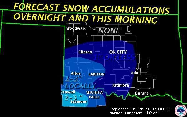
THE MAIN UNCERTAINTIES IN THIS SET OF TAFS IS THE EXTENT OF THE
SNOW... AND THE MVFR-LEVEL CLOUDS. THE CLOUDS WILL LIKELY COME AND
GO OVERNIGHT... AND WILL BE VERY HARD TO PREDICT ACCURATELY. SNOW
NOW OVER THE PANHANDLES WILL SPREAD SOUTHEAST... AND MAY AFFECT A
FEW SITES... SUCH AS KGAG AND EVEN KOKC/KOUN... THAT DO NOT HAVE
-SN MENTIONED IN THE TAF. IF SNOW DOES OCCUR AT THESE SITES... IT
COULD START AS EARLY AS THIS EVENING AT KGAG... AND AROUND SUNRISE
AT KOKC AND VICINITY.
VISIBILITIES SHOULD REMAIN IN THE MVFR
CATEGORY AT THESE SITES.
0 likes   

Peanut432
Tropical Storm
Tropical Storm
Posts: 119
Joined: Mon Jan 25, 2010 10:21 pm
Location: Hollis Ok

Re: Southern Plains winter wx thread (2009-2010)

#613 Postby Peanut432 » Mon Feb 22, 2010 8:22 pm

It looks like its snowing over the entire Texas panhandle and radar trends have it moving SSE. It appears the storm is farther east than forecast ed. Childress this mourning had 30% chance of snow and now has 70% chance. Talk to my Mom and its snowing just 15 mile into the Texas panhandle and is moving almost due east.
0 likes   

User avatar
Extremeweatherguy
Category 5
Category 5
Posts: 11095
Joined: Mon Oct 10, 2005 8:13 pm
Location: Houston, TX

#614 Postby Extremeweatherguy » Mon Feb 22, 2010 9:26 pm

Snow is pushing into Oklahoma:

http://www.wunderground.com/radar/radbl ... rainsnow=0

http://radar.weather.gov/Conus/southplains_loop.php

The question now is how far east does it get, and how long does the snow band survive?

Based on the large-scale radar trends, it seems like some slight weakening has occurred over the last few hours, but it still looks like a pretty formidable band overall and shows no signs of going away anytime soon.

UPDATE: As of 10:25pm there appears to be further signs of a weakening trend on radar. Unless re-development occurs overnight, I think central Oklahoma's chances at seeing much more than some flurries or very light snow showers is diminishing.
Last edited by Extremeweatherguy on Mon Feb 22, 2010 11:26 pm, edited 1 time in total.
0 likes   

User avatar
Extremeweatherguy
Category 5
Category 5
Posts: 11095
Joined: Mon Oct 10, 2005 8:13 pm
Location: Houston, TX

#615 Postby Extremeweatherguy » Mon Feb 22, 2010 11:17 pm

The 00z GFS is coming in MUCH less impressive for the Friday storm. It looks like just a fast shot at precipitation, with most of the accumulating snow being confined to NE Oklahoma and into Arkansas. There are still a few days for the model runs to shift back and forth, but overall I am starting to feel like this will not be too big of a deal. The system that will follow Sunday into Monday, on the other hand, continues to look VERY impressive and could potentially bring widespread heavy snows to the region.

00z GFS 36 hour (liquid equivalent) precipitation map for the Sunday - Monday system:
Image

00z GFS Accumulated snow at hour 156:
Image

I still think the model might be underestimating the event further east as it tires to open the upper low. In reality, those higher snow totals seen in the panhandles *might* need to be expanded eastward in future runs. We shall see.
0 likes   

User avatar
Extremeweatherguy
Category 5
Category 5
Posts: 11095
Joined: Mon Oct 10, 2005 8:13 pm
Location: Houston, TX

#616 Postby Extremeweatherguy » Tue Feb 23, 2010 2:32 am

OUN has expanded their accumulation graphic to now include OKC...

Image

I'm still skeptical that we will get much in the way of accumulations though. So far all I have are some very light snow showers outside (more in the way of "flurries"), so unless it picks up to a steadier snow shower overnight, it will be pretty difficult to even accumulate a light dusting.

UPDATE: I was correct. We only managed to get the very slightest hint of accumulation last night. Nothing on the ground, just a little bit of light iciness on some of the cars.
0 likes   

User avatar
Extremeweatherguy
Category 5
Category 5
Posts: 11095
Joined: Mon Oct 10, 2005 8:13 pm
Location: Houston, TX

#617 Postby Extremeweatherguy » Tue Feb 23, 2010 8:44 am

Image

Image
0 likes   

Peanut432
Tropical Storm
Tropical Storm
Posts: 119
Joined: Mon Jan 25, 2010 10:21 pm
Location: Hollis Ok

Re: Southern Plains winter wx thread (2009-2010)

#618 Postby Peanut432 » Tue Feb 23, 2010 2:53 pm

Gfs on twister data has the entire texas panhandle buried under 6-12 inches of snow(if its cold enough) and then moves heavy precip over north Texas.

Will this be all snow? Could the area along the red river around Childress and WF get another Ice storm? Last storm that the models agreed on like this was the early January storm that gave me .75-1 inch of ice of everything. Some people in the county still have no power. My aunt went 19 days.
0 likes   

msstateguy83

#619 Postby msstateguy83 » Tue Feb 23, 2010 6:36 pm

well the 18z run to me seems a little dryer, warmer looking at kokc, ksps sites showing temps above frzing
with only rain @ sps with a rain/snow mix towards the end of the event in the kokc zone... i dont really buy
into this though 18z isnt the best run to look at anyways so will see what the 00z has to say to see if this
trend continues. i have not had the time today also to look at the euro will later on but if someone has
plz feel free to chime in w/your thoughts...
0 likes   

User avatar
Extremeweatherguy
Category 5
Category 5
Posts: 11095
Joined: Mon Oct 10, 2005 8:13 pm
Location: Houston, TX

#620 Postby Extremeweatherguy » Tue Feb 23, 2010 7:00 pm

18z GFS valid Sunday evening..

Image

It still looks like the model is showing a good 500mb pattern for a decent snow event across the southern plains IMO. Whenever you get a healthy ULL like that and a nice S to N upper level flow over the area, you can almost guarantee that there will be a decent precipitation event..and in this case with the cold air in place and added help of dynamic cooling due to the ULL, probably a decent snow event. There are still many things to be worked out, such as the exact track and strength of the surface and upper level features, but overall I still feel that this storm has *potential* to be a big one for the region...especially for those folks along and just north of the track of the ULL.
0 likes   


Return to “Winter Weather”

Who is online

Users browsing this forum: No registered users and 12 guests