Southern Plains winter wx thread (2009-2010)
Moderator: S2k Moderators
Forum rules
 The posts in this forum are NOT official forecast and should not be used as such. They are just the opinion of the poster and may or may not be backed by sound meteorological data. They are NOT endorsed by any professional institution or STORM2K.

The posts in this forum are NOT official forecast and should not be used as such. They are just the opinion of the poster and may or may not be backed by sound meteorological data. They are NOT endorsed by any professional institution or STORM2K.
-
Extremeweatherguy

- Category 5

- Posts: 11095
- Joined: Mon Oct 10, 2005 8:13 pm
- Location: Houston, TX

LBK AFD for Sunday and Monday
UPPER LEVEL RIDGING AND NW FLOW ALOFT WILL PREVAIL THROUGH THE
FIRST-HALF OF THE WEEKEND...AS THE NEXT PACIFIC NW SYSTEM MOVES
ONSHORE ON SATURDAY. MEDIUM TO LONG RANGE MODELS PROJECTS THE CLOSED
UA LOW TO DIG SE ACROSS THE DESERT SW AND ACROSS EASTERN NEW MEXICO
BY SUNDAY AFTERNOON. THEREAFTER THE UA LOW WILL MOVE SE ACROSS THE
SOUTH PLAINS...ALONG WITH ITS ASSOCIATED COLD FRONT SUNDAY
NIGHT/EARLY MONDAY MORNING. AS IT PROPAGATES SE MONDAY MORNING IT
EVOLVES INTO AN OPEN WAVE PER THE GFS...DEPICTING THE SAID SYSTEM TO
MOVE TOWARDS THE SE CONUS TUESDAY MORNING...VERSUS THE ECMWF
CONTINUAL CLOSED LOW DELINEATION. ADDITIONALLY...THE GFS IS ALSO
QUICKER WITH THE UA LOW PROPAGATION TO THE SE CONUS.
THE FACT THAT IT INITIALIZES AS A CLOSED LOW HINTS AT ITS POTENCY
WITH SYNOPTIC LIFT INCREASING SATURDAY NIGHT THROUGH SUNDAY NIGHT
PER MODEL SOUNDINGS. AS A RESULT.../IF THE TRAJECTORY IS UNCHANGED/
THE MAIN CONCERN WILL BE SNOWFALL ACCUMULATION AS THE GFS IS SHOWING
SIGNIFICANT SNOWFALL POTENTIAL BEGINNING SUNDAY EVENING/NIGHT WITH
THE ONSET OF THE NORTHERLY COLD FRONTAL BOUNDARY.
HOWEVER...ANALYZING LATER MODEL RUNS IS DESIRED AS A CHANGE IN THE
UA LOW TRACK COULD AFFECT SNOWFALL ACCUMULATION. ALTHOUGH PRECIP
COULD LINGER THROUGH LATE MONDAY MORNING/AFTERNOON...WILL SHUNT OFF
PRECIP CHANCES EARLY MONDAY MORNING DUE TO UNCERTAINTY ATTM.
THEREAFTER...UPPER LEVEL RIDGING ACROSS THE WESTERN CONUS AND NW
FLOW ALOFT WILL ONCE AGAIN PREVAIL ON TUESDAY.
&&
0 likes
-
msstateguy83
more i look at the other models my confidence is the same this **COULD BE** the biggest event of the year
i mean bigger then dfw, bigger then christmas eve in being so widespread also would not shock me to see
higher amts we could be looking at CRAZY amts of snow for this region if this verifys....
i mean bigger then dfw, bigger then christmas eve in being so widespread also would not shock me to see
higher amts we could be looking at CRAZY amts of snow for this region if this verifys....
0 likes
Re:
msstateguy83 wrote:more i look at the other models my confidence is the same this **COULD BE** the biggest event of the year
i mean bigger then dfw, bigger then christmas eve in being so widespread also would not shock me to see
higher amts we could be looking at CRAZY amts of snow for this region if this verifys....
Those are pretty big blockbusters you're comparing it to
0 likes
The above post and any post by Ntxw is NOT an official forecast and should not be used as such. It is just the opinion of the poster and may or may not be backed by sound meteorological data. It is NOT endorsed by any professional institution including Storm2k. For official information, please refer to NWS products.
Help support Storm2K!
-
Portastorm

- Storm2k Moderator

- Posts: 9787
- Age: 61
- Joined: Fri Jul 11, 2003 9:16 am
- Location: South Austin, TX
- Contact:
Re: Southern Plains winter wx thread (2009-2010)
I'm nonplussed by this storm. Maybe a few flurries for the Red River area and Oklahoma. That's it! 
0 likes
Re: Southern Plains winter wx thread (2009-2010)
Portastorm wrote:I'm nonplussed by this storm. Maybe a few flurries for the Red River area and Oklahoma. That's it!
Pfft! It's nothing compared to the mondo snow you got today Portastorm!
Edit: We need a label for it.
0 likes
The above post and any post by Ntxw is NOT an official forecast and should not be used as such. It is just the opinion of the poster and may or may not be backed by sound meteorological data. It is NOT endorsed by any professional institution including Storm2k. For official information, please refer to NWS products.
Help support Storm2K!
Help support Storm2K!
-
Portastorm
- Storm2k Moderator
- Posts: 9787
- Age: 61
- Joined: Fri Jul 11, 2003 9:16 am
- Location: South Austin, TX
- Contact:
Re: Southern Plains winter wx thread (2009-2010)
Ntxw wrote:Portastorm wrote:I'm nonplussed by this storm. Maybe a few flurries for the Red River area and Oklahoma. That's it!
Pfft! It's nothing compared to the mondo snow you got today Portastorm!
Now you're talking ... that's right. I survived Blizzard 2010 in Austin!
Seriously, this next storm has me intrigued. I don't know if I concur with msstateguy83's bullish thoughts quite yet ... but I think North Texas and Oklahoma have a lot to watch in the next few days. I really don't think it'll do much south of there. I've seen some thoughts about today's 12z Euro run suggesting it could mean a winter storm for central and north Texas but I don't see that. The low is too far north. I think we're done for winter here in Austin.
But you Metroplexers and Red Riveruns ... y'all have more "fun" ahead!
Label for today's storm? How about: The Blizzard of AUS (instead of Oz)??
0 likes
Edit: Blizzard of AUS, I like that!
0 likes
The above post and any post by Ntxw is NOT an official forecast and should not be used as such. It is just the opinion of the poster and may or may not be backed by sound meteorological data. It is NOT endorsed by any professional institution including Storm2k. For official information, please refer to NWS products.
Help support Storm2K!
Help support Storm2K!
-
Extremeweatherguy
- Category 5
- Posts: 11095
- Joined: Mon Oct 10, 2005 8:13 pm
- Location: Houston, TX
Re:
Yeah, the potential is definitely there IMO. I am hesitant to compare it to those huge events just yet due to the fact that we are still several days out and also because surface temperatures might be a bit marginal, but I do think that a widespread accumulating snowstorm of at least a few inches is very possible for the southern plains with this, and the opportunity for large amounts (6+ inches) is certainly on the table if things can come together right.msstateguy83 wrote:more i look at the other models my confidence is the same this **COULD BE** the biggest event of the year
i mean bigger then dfw, bigger then christmas eve in being so widespread also would not shock me to see
higher amts we could be looking at CRAZY amts of snow for this region if this verifys....
0 likes
EWG, what's the record snowfall in a storm\24hr period for OKC in march?
0 likes
The above post and any post by Ntxw is NOT an official forecast and should not be used as such. It is just the opinion of the poster and may or may not be backed by sound meteorological data. It is NOT endorsed by any professional institution including Storm2k. For official information, please refer to NWS products.
Help support Storm2K!
Help support Storm2K!
-
Extremeweatherguy
- Category 5
- Posts: 11095
- Joined: Mon Oct 10, 2005 8:13 pm
- Location: Houston, TX
Re:
Its a surprisingly large 11.3 inches back on March 19th, 1924:Ntxw wrote:EWG, what's the record snowfall in a storm\24hr period for OKC in march?
http://www.srh.noaa.gov/oun/climate/get ... ar&type=pr
0 likes
Wow, that's impressive. Lets see if we can top that next week!
0 likes
The above post and any post by Ntxw is NOT an official forecast and should not be used as such. It is just the opinion of the poster and may or may not be backed by sound meteorological data. It is NOT endorsed by any professional institution including Storm2k. For official information, please refer to NWS products.
Help support Storm2K!
Help support Storm2K!
-
Extremeweatherguy
- Category 5
- Posts: 11095
- Joined: Mon Oct 10, 2005 8:13 pm
- Location: Houston, TX
Re:
That would certainly be amazing if we could manage to top the 11.3" March record! Right now it doesn't look too terribly likely that we will even get close to that much snow, but who knows. Anything seems to be within the realm of possibility this winter! lolNtxw wrote:Wow, that's impressive. Lets see if we can top that next week!
0 likes
Can say that again, already amazing both DFW and OKC broke their daily snowfall records for a single storm. Another big one and both could break all season records (though I'm not sure what the season record is for OKC, I think it was around 25 inches).
0 likes
The above post and any post by Ntxw is NOT an official forecast and should not be used as such. It is just the opinion of the poster and may or may not be backed by sound meteorological data. It is NOT endorsed by any professional institution including Storm2k. For official information, please refer to NWS products.
Help support Storm2K!
Help support Storm2K!
-
Extremeweatherguy
- Category 5
- Posts: 11095
- Joined: Mon Oct 10, 2005 8:13 pm
- Location: Houston, TX
Totally make-able!
0 likes
The above post and any post by Ntxw is NOT an official forecast and should not be used as such. It is just the opinion of the poster and may or may not be backed by sound meteorological data. It is NOT endorsed by any professional institution including Storm2k. For official information, please refer to NWS products.
Help support Storm2K!
Help support Storm2K!
-
msstateguy83
Re: Southern Plains winter wx thread (2009-2010)
84 hrs out on the NAM... system over cali the one heading our way for late sun/mon looks quite impressive 


0 likes
-
Extremeweatherguy
- Category 5
- Posts: 11095
- Joined: Mon Oct 10, 2005 8:13 pm
- Location: Houston, TX
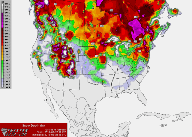
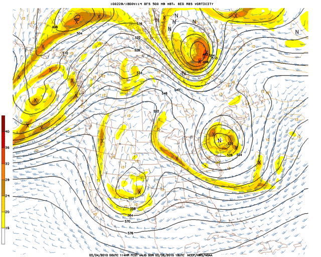
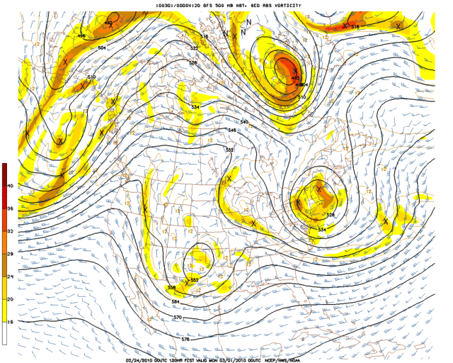
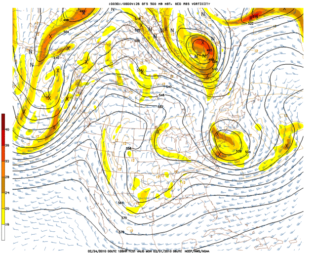
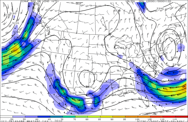
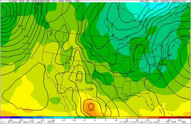
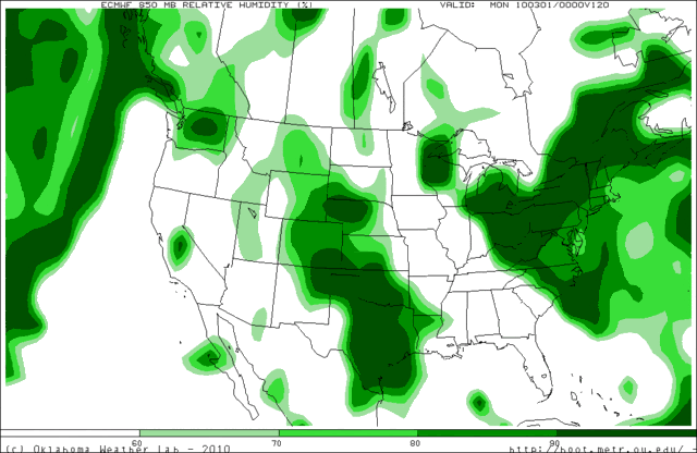
00z GFS...
114 HRS:
120 HRS:
126 HRS:
36 HR PRECIP (Next Sunday morning through Monday afternoon):
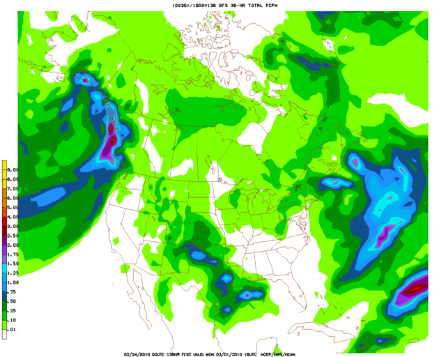
The general idea of this run still looks to support a winter event, but I believe that the GFS could be underestimating precipitation amounts over Oklahoma just a little bit. This has been going back and forth with each run though, so at this point I am not worrying too much about the specifics. Those can be worked out as we get closer to the event.
114 HRS:
120 HRS:
126 HRS:
36 HR PRECIP (Next Sunday morning through Monday afternoon):
The general idea of this run still looks to support a winter event, but I believe that the GFS could be underestimating precipitation amounts over Oklahoma just a little bit. This has been going back and forth with each run though, so at this point I am not worrying too much about the specifics. Those can be worked out as we get closer to the event.
0 likes
I think the key to that storm will be if it maintains itself as a cutoff low. If it does, the gulf low forming won't have as much of a chance to zap the moisture away from it. Lets see what tonight's ECMWF says.
0 likes
The above post and any post by Ntxw is NOT an official forecast and should not be used as such. It is just the opinion of the poster and may or may not be backed by sound meteorological data. It is NOT endorsed by any professional institution including Storm2k. For official information, please refer to NWS products.
Help support Storm2K!
Help support Storm2K!
-
Extremeweatherguy
- Category 5
- Posts: 11095
- Joined: Mon Oct 10, 2005 8:13 pm
- Location: Houston, TX
Who is online
Users browsing this forum: No registered users and 9 guests