Southern Plains winter wx thread (2009-2010)
Moderator: S2k Moderators
Forum rules
 The posts in this forum are NOT official forecast and should not be used as such. They are just the opinion of the poster and may or may not be backed by sound meteorological data. They are NOT endorsed by any professional institution or STORM2K.

The posts in this forum are NOT official forecast and should not be used as such. They are just the opinion of the poster and may or may not be backed by sound meteorological data. They are NOT endorsed by any professional institution or STORM2K.
-
Extremeweatherguy

- Category 5

- Posts: 11095
- Joined: Mon Oct 10, 2005 8:13 pm
- Location: Houston, TX
Re: Southern Plains winter wx thread (2009-2010)
I will be in Texas for the first half of this weekend and will thus miss the heart of the storm up in OKC. If this were December I would be upset about having to miss it, but truthfully I am not too mad that I will be missing this one. Seeing the aftermath when I return on Sunday will be enough for me. From the looks of it though, this could be a pretty significant storm. The NWS is calling for 4-6" widespread throughout central Oklahoma, with a few locations possibly reaching or topping the 8" mark. That is not too shabby at all! The all-time seasonal snowfall record at OKC definitely looks to be in jeopardy with this storm.
0 likes

Storm looks to deepen even further and slow down. Eastern Oklahoma is going to get punished! Folks there should probably prepare for the worst of this system.
0 likes
The above post and any post by Ntxw is NOT an official forecast and should not be used as such. It is just the opinion of the poster and may or may not be backed by sound meteorological data. It is NOT endorsed by any professional institution including Storm2k. For official information, please refer to NWS products.
Help support Storm2K!
-
BlueIce
- S2K Supporter

- Posts: 194
- Age: 35
- Joined: Mon Sep 01, 2008 10:05 pm
- Location: Oklahoma City, Oklahoma
Re: Southern Plains winter wx thread (2009-2010)
Winter Storm Warning up!!
URGENT - WINTER WEATHER MESSAGE
NATIONAL WEATHER SERVICE NORMAN OK
1145 AM CDT FRI MAR 19 2010
...SIGNIFICANT WINTER STORM BEARING DOWN ON THE SOUTHERN PLAINS...
A SIGNIFICANT WINTER STORM IS EXPECTED TO AFFECT OKLAHOMA
BEGINNING IN NORTHWEST OKLAHOMA AS EARLY AS TONIGHT. MUCH COLDER
AIR IS BEGINNING TO MOVE INTO NORTHWESTERN OKLAHOMA... AND WILL
OVERSPREAD THE REST OF OKLAHOMA AND NORTHERN TEXAS LATER TODAY AND
OVERNIGHT. A POWERFUL LATE-WINTER STORM SYSTEM WILL BRING SNOW AND
BLOWING SNOW TO MOST OF NORTHERN... CENTRAL... AND EASTERN
OKLAHOMA... BEGINNING IN NORTHWESTERN OKLAHOMA TONIGHT AND THEN
SPREADING SOUTHEAST TONIGHT AND SATURDAY. HEAVY SNOW... STRONG
WINDS... AND SEVERE BLOWING AND DRIFTING SNOW WILL LEAD TO
BLIZZARD OR NEAR- BLIZZARD CONDITIONS IN PORTIONS OF OKLAHOMA SATURDAY
AND SATURDAY NIGHT. SNOW WILL CONTINUE TO ACCUMULATE INTO SUNDAY.
TRAVEL WILL BECOME VERY DIFFICULT OR IMPOSSIBLE IN SOME AREAS THIS
WEEKEND. THIS IS A POTENTIALLY DANGEROUS WINTER STORM SITUATION
WHICH NEEDS TO BE TAKEN SERIOUSLY. PREPARATIONS FOR SEVERE WINTER
WEATHER SHOULD BE PERFORMED TODAY... AND COMPLETED BY TONIGHT.
OKZ008-012-013-018>020-024>032-042-200045-
/O.UPG.KOUN.WS.A.0003.100320T1200Z-100321T1200Z/
/O.NEW.KOUN.WS.W.0004.100320T0900Z-100322T0000Z/
KAY-GARFIELD-NOBLE-KINGFISHER-LOGAN-PAYNE-CANADIAN-OKLAHOMA-
LINCOLN-GRADY-MCCLAIN-CLEVELAND-POTTAWATOMIE-SEMINOLE-HUGHES-
PONTOTOC-
INCLUDING THE CITIES OF...PONCA CITY...ENID...PERRY...
KINGFISHER...GUTHRIE...STILLWATER...YUKON...EL RENO...MUSTANG...
OKLAHOMA CITY...CHANDLER...CHICKASHA...PURCELL...NORMAN...MOORE...
SHAWNEE...SEMINOLE...HOLDENVILLE...ADA
1145 AM CDT FRI MAR 19 2010
...WINTER STORM WARNING IN EFFECT FROM 4 AM SATURDAY TO 7 PM CDT
SUNDAY...
THE NATIONAL WEATHER SERVICE IN NORMAN HAS ISSUED A WINTER STORM
WARNING FOR HEAVY SNOW AND NEAR BLIZZARD CONDITIONS...WHICH IS IN
EFFECT FROM 4 AM SATURDAY TO 7 PM CDT SUNDAY. THE WINTER STORM
WATCH IS NO LONGER IN EFFECT.
* TIMING: EARLY SATURDAY MORNING THROUGH SUNDAY MORNING.
* MAIN IMPACT: HEAVY SNOW AND STRONG WINDS GUSTING OVER 40 MPH
CREATING NEAR-BLIZZARD CONDITIONS. SNOWFALL OF 4 TO 8 INCHES IS
LIKELY OVER THE WARNING AREA WITH. LOCAL AMOUNTS OVER 8 INCHES
WILL BE POSSIBLE ACROSS PORTIONS OF CENTRAL AND EAST CENTRAL
OKLAHOMA.
* OTHER IMPACTS: WIND CHILL TEMPERATURES WILL FALL INTO THE
TEENS.
0 likes
Re: Southern Plains winter wx thread (2009-2010)
NAM might be overdoing it, but astonishing nonetheless.

GFS

GFS
0 likes
The above post and any post by Ntxw is NOT an official forecast and should not be used as such. It is just the opinion of the poster and may or may not be backed by sound meteorological data. It is NOT endorsed by any professional institution including Storm2k. For official information, please refer to NWS products.
Help support Storm2K!
Help support Storm2K!
-
somethingfunny

- ChatStaff

- Posts: 3926
- Age: 35
- Joined: Thu May 31, 2007 10:30 pm
- Location: McKinney, Texas
Re: Southern Plains winter wx thread (2009-2010)
O_O
Looks like I'm heading up US 75 as soon as I get off work Saturday Night, we'll hit the Indian Nation Turnpike and see how far I can go before they shut down the road.

Looks like I'm heading up US 75 as soon as I get off work Saturday Night, we'll hit the Indian Nation Turnpike and see how far I can go before they shut down the road.
0 likes
Is it any coincidence EWG is away, therefore OKC is experiencing the second blizzard of the season? 
0 likes
The above post and any post by Ntxw is NOT an official forecast and should not be used as such. It is just the opinion of the poster and may or may not be backed by sound meteorological data. It is NOT endorsed by any professional institution including Storm2k. For official information, please refer to NWS products.
Help support Storm2K!
Help support Storm2K!
-
Extremeweatherguy
- Category 5
- Posts: 11095
- Joined: Mon Oct 10, 2005 8:13 pm
- Location: Houston, TX
Re: Southern Plains winter wx thread (2009-2010)
I'm actually not that upset about it this go around though. I've seen enough snow and cold this winter and missing this storm doesn't feel as bad as missing the Christmas Eve blizzard. As long as I can get back safely Sunday afternoon, then I'll be content. Seeing the leftover (and hopefully rapidly melting) accumulation will be enough for me.
One more thing to add --> Once this storm is gone, I say BRING ON SPRING! I am definitely ready for warmer weather and thunderstorms to become the norm again!
0 likes
-
BlueIce
- S2K Supporter
- Posts: 194
- Age: 35
- Joined: Mon Sep 01, 2008 10:05 pm
- Location: Oklahoma City, Oklahoma
Re: Southern Plains winter wx thread (2009-2010)
Extremeweatherguy wrote::uarrow: Lol, yeah what are the chances that during the one weekend I go away in the last 2 months Oklahoma gets another blizzard.
I'm actually not that upset about it this go around though. I've seen enough snow and cold this winter and missing this storm doesn't feel as bad as missing the Christmas Eve blizzard. As long as I can get back safely Sunday afternoon, then I'll be content. Seeing the leftover (and hopefully rapidly melting) accumulation will be enough for me.
One more thing to add --> Once this storm is gone, I say BRING ON SPRING! I am definitely ready for warmer weather and thunderstorms to become the norm again!
I'll second that!!
0 likes
-
BlueIce
- S2K Supporter
- Posts: 194
- Age: 35
- Joined: Mon Sep 01, 2008 10:05 pm
- Location: Oklahoma City, Oklahoma
Re: Southern Plains winter wx thread (2009-2010)
Current Conditions in Edmond, Oklahoma as of 3:00 AM. Winter precip started around 2:30 AM here and has now coated the cars with a thin layer of freezing rain. Depending on when this switches over to snow we may have enough ice around in the morning to make travel in the metro more challenging. I am expecting the change over to Snow any time now.
Updated NWS totals.

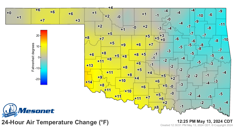
Updated Temp Change
Current freezing line
Updated NWS totals.
Updated Temp Change
Current freezing line
0 likes
-
Extremeweatherguy
- Category 5
- Posts: 11095
- Joined: Mon Oct 10, 2005 8:13 pm
- Location: Houston, TX
Re: Southern Plains winter wx thread (2009-2010)
It looks like Oklahoma received a pretty decent round of snowfall this morning. Any reports on accumulations so far?
Beyond this first round though, I am starting to wonder if this storm will really be as bad as expected? It seems like, via radar trends, that a significant break in anything but flurries is coming soon. The models did not really show this break being as significant as it appears, so I wouldn't be surprised if the final accumulations were slightly less than predicted. We shall see.
EDIT: Never mind. That band to the west is starting to look very impressive. It could easily bring the accumulations up into the forecasted range IMO.
Last edited by Extremeweatherguy on Sat Mar 20, 2010 12:23 pm, edited 1 time in total.
0 likes
-
srainhoutx

- S2K Supporter
- Posts: 6919
- Age: 66
- Joined: Sun Jan 14, 2007 11:34 am
- Location: Haywood County, NC
- Contact:
Re: Southern Plains winter wx thread (2009-2010)
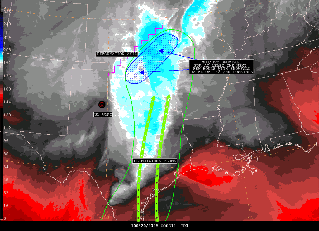
SATELLITE PRECIPITATION ESTIMATES..DATE/TIME 03/20/10 1328Z
SATELLITE ANALYSIS BRANCH/NESDIS---NPPU---TEL.301-763-8678
LATEST DATA USED: GOES-12: 1315Z BELGE
.
LOCATION...MISSOURI...OKLAHOMA...KANSAS...
.
ATTN WFOS...SGF...EAX...TSA...TOP...ICT...OUN...
ATTN RFCS...MBRFC...ABRFC...
.
EVENT...MOD/HVY SNOWFALL AFFECTING OK/KS.
.
SATELLITE ANALYSIS AND TRENDS...WV IMAGERY SHOWING UL VORT MOVING
INTO THE PANHANDLE OF TX AND SHOULD CLOSE OFF AS IT MOVES FURTHER EAST
TONIGHT. LOOKING AT THE LATEST 12UTC PW ANALYSIS..THE BEST LL MOISTURE
REMAINS FROM ERN TX NORTHWARD INTO ERN OK WITH SLIGHTLY LESSER BUT STILL
FAVORABLE MOISTURE INTO CNTRL AND SE KS. THIS MOISTURE PLUME ALONG WITH
A DEFORMATION AXIS ACROSS THIS REGION IS LINING UP NICELY WITH THE BAND
OF MOD TO HVY SNOWFALL SETTING UP FROM CNTRL/NRN OK INTO SE KS. IR STLT
SHOWS COOLING CLOUDS TOPS ASSOCIATED WITH THIS BAND AS WELL WHICH ALL IN
ALL COULD LEAD TO INCREASED SNOWFALL RATES OVER THE NEXT FEW HOURS WITH
THE POSSIBILITY OF 1-2" SNOW RATES PER HOURS. WILL CONTINUE TO MONITOR...
0 likes
Carla/Alicia/Jerry(In The Eye)/Michelle/Charley/Ivan/Dennis/Katrina/Rita/Wilma/Ike/Harvey
Member: National Weather Association
Wx Infinity Forums
http://wxinfinity.com/index.php
Facebook.com/WeatherInfinity
Twitter @WeatherInfinity
Member: National Weather Association
Wx Infinity Forums
http://wxinfinity.com/index.php
Facebook.com/WeatherInfinity
Twitter @WeatherInfinity
-
Extremeweatherguy
- Category 5
- Posts: 11095
- Joined: Mon Oct 10, 2005 8:13 pm
- Location: Houston, TX
Re: Southern Plains winter wx thread (2009-2010)
Well it seems like this storm never really materialized like it could of for central Oklahoma and definitely hasn't lived up to its full potential so far. As of 11pm CT the highest snow totals I can find around the immediate OKC metro area are between 3-5", with most locations in the metro only picking up a windblown 1-3". While that still qualifies as a significant storm this late in the season, it is by no means the 4-8+" that was originally expected.
The same cannot be said for places further north and east though. In north central and northeast Oklahoma the snow totals are coming in much higher. 7" is being reported in Ponca City this evening, and there are possibly even higher totals just east of there.
The same cannot be said for places further north and east though. In north central and northeast Oklahoma the snow totals are coming in much higher. 7" is being reported in Ponca City this evening, and there are possibly even higher totals just east of there.
0 likes
-
somethingfunny
- ChatStaff
- Posts: 3926
- Age: 35
- Joined: Thu May 31, 2007 10:30 pm
- Location: McKinney, Texas
Re: Southern Plains winter wx thread (2009-2010)
Seeing that the models aren't predicting any more winter weather for Oklahoma and NW Texas and most likely over for the winter (Models are all very warm) here is the latest from KOUN on the winter statistics. I'm a little surprised at the relatively low numbers in Wichita Falls for records related to regions surrounding it. I assumed the Falls gets lots of snow being where it is.
http://www.srh.noaa.gov/news/display_cmsstory.php?wfo=oun&storyid=48077&source=0
http://www.srh.noaa.gov/news/display_cmsstory.php?wfo=oun&storyid=48077&source=0
0 likes
The above post and any post by Ntxw is NOT an official forecast and should not be used as such. It is just the opinion of the poster and may or may not be backed by sound meteorological data. It is NOT endorsed by any professional institution including Storm2k. For official information, please refer to NWS products.
Help support Storm2K!
Help support Storm2K!
Who is online
Users browsing this forum: No registered users and 89 guests