Southern Plains winter wx thread (2009-2010)

Winter Weather Discussion

Moderator: S2k Moderators

Forum rules

The posts in this forum are NOT official forecast and should not be used as such. They are just the opinion of the poster and may or may not be backed by sound meteorological data. They are NOT endorsed by any professional institution or STORM2K.

Help Support Storm2K
Message
Author
User avatar
Extremeweatherguy
Category 5
Category 5
Posts: 11095
Joined: Mon Oct 10, 2005 8:13 pm
Location: Houston, TX

#581 Postby Extremeweatherguy » Wed Feb 10, 2010 11:05 am

The 12z GFS has the same idea as the NAM...

Image

It looks likely that there will be some light snow all the way north to I-40, but the bulk of the heavier bands and more significant accumulations should be closer to the Red River. It could be a close call though. Any slight deviation north/south could mean big changes in the forecast for those near/just south of the I-40 corridor.
0 likes   

User avatar
Extremeweatherguy
Category 5
Category 5
Posts: 11095
Joined: Mon Oct 10, 2005 8:13 pm
Location: Houston, TX

#582 Postby Extremeweatherguy » Wed Feb 10, 2010 11:25 am

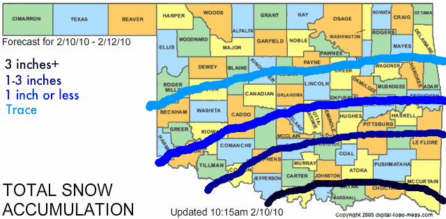
Based on my current read of the situation, here is a look at my prediction for snow amounts in the state of Oklahoma during this event...
Image

These areas may need to be adjusted north or south some depending on how the snow bands actually develop tomorrow and also depending on how the surface temperatures set up, but for now I think this is a pretty good idea of how things will play out across the area with this storm.

The following post is NOT an official forecast and should not be used as such. It is just the opinion of the poster and may or may not be backed by sound meteorological data. It is NOT endorsed by any professional institution including storm2k.org. For official information, please refer to NWS products.


VERIFICATION:

Actual storm snow totals: http://i43.photobucket.com/albums/e371/ ... als_14.jpg

Overall my general idea verified with higher snowfall amounts south and lower totals as you moved northward. I did underestimate the snowfall amounts in a few areas though. A few spots in the 1" or less zone wound up receiving as much as 2-3", and a few spots in the 1-3" zone wound up receiving as much as 4-6". I also could have bumped up my wording for the southernmost zone. While the entire 3"+ area did verify, it is worth noting that some places down there picked up as much as 9.2" of snow, which is well above 3". In retrospect, a 6"+ forecast probably would have emphasized the severity better.

In the end I give myself a B- for this forecast. My general thinking was correct, but my snow totals were a bit off (too low) in a few areas.
Last edited by Extremeweatherguy on Sat Feb 20, 2010 4:34 pm, edited 2 times in total.
0 likes   

User avatar
Extremeweatherguy
Category 5
Category 5
Posts: 11095
Joined: Mon Oct 10, 2005 8:13 pm
Location: Houston, TX

#583 Postby Extremeweatherguy » Wed Feb 10, 2010 9:31 pm

The 00z NAM suggests that the snow totals on my map above might need to be shifted southward. Let's see if the 00z GFS agrees when it comes out.
0 likes   

User avatar
Extremeweatherguy
Category 5
Category 5
Posts: 11095
Joined: Mon Oct 10, 2005 8:13 pm
Location: Houston, TX

#584 Postby Extremeweatherguy » Wed Feb 10, 2010 10:42 pm

Well that's weird. A random snow band just popped up on radar west of OKC. As of now it looks to avoid my area for the time being, but it will be interesting to see if more of these bands can arise later tonight. The NWS thinks its possible and has added a 30% chance of snow to the forecast for tonight.

http://www.wunderground.com/radar/radbl ... rainsnow=0
Last edited by Extremeweatherguy on Thu Feb 11, 2010 12:24 am, edited 2 times in total.
0 likes   

User avatar
Extremeweatherguy
Category 5
Category 5
Posts: 11095
Joined: Mon Oct 10, 2005 8:13 pm
Location: Houston, TX

#585 Postby Extremeweatherguy » Wed Feb 10, 2010 10:48 pm

BTW, the 00z GFS is also coming in much more impressive than the NAM for Oklahoma tomorrow, and would mean a better chance for light accumulations reaching up to near I-40.

Image

The big question is...which model will be right?

Based on the fact that we already have light snow bands developing here tonight, I am slightly more inclined to believe the GFS right now, but I guess we will not know for sure until it is actually happening (or not).
0 likes   

User avatar
Extremeweatherguy
Category 5
Category 5
Posts: 11095
Joined: Mon Oct 10, 2005 8:13 pm
Location: Houston, TX

#586 Postby Extremeweatherguy » Thu Feb 11, 2010 1:02 pm

We have light/moderate snow coming down south of OKC right now (in cleveland county). Its beginning to accumulate a little bit on the grass and cars too! It will be interesting to see how long this snow lasts, because if it keeps up much longer, then the NWS forecast of just a "trace" will need to be upped.
0 likes   

BlueIce
S2K Supporter
S2K Supporter
Posts: 194
Age: 35
Joined: Mon Sep 01, 2008 10:05 pm
Location: Oklahoma City, Oklahoma

Re: Southern Plains winter wx thread (2009-2010)

#587 Postby BlueIce » Thu Feb 11, 2010 8:26 pm

Looks like our friends in Dallas got a pretty decent amount of snow out of this system. I saw reports of up to 10 inches in some areas! Looking ahead the next week it looks kind of quite, I heard one of the local TV guys talk about the potential for another strong system around the 25th. I guess we will have to wait and see.
0 likes   

User avatar
Extremeweatherguy
Category 5
Category 5
Posts: 11095
Joined: Mon Oct 10, 2005 8:13 pm
Location: Houston, TX

Re: Southern Plains winter wx thread (2009-2010)

#588 Postby Extremeweatherguy » Thu Feb 11, 2010 8:41 pm

BlueIce wrote:Looks like our friends in Dallas got a pretty decent amount of snow out of this system. I saw reports of up to 10 inches in some areas! Looking ahead the next week it looks kind of quite, I heard one of the local TV guys talk about the potential for another strong system around the 25th. I guess we will have to wait and see.
Next week is kind of a "?" right now. Depending on what model you look at, there may or may not be a few systems to deal with. Either way though, it definitely looks like the cold will continue. A new arctic front should arrive on Sunday morning (possibly associated with a few light snow showers? http://www.nco.ncep.noaa.gov/pmb/nwprod ... p_072l.gif), followed by lows dipping back into the teens/lower 20s Sunday and Monday nights. Brr.

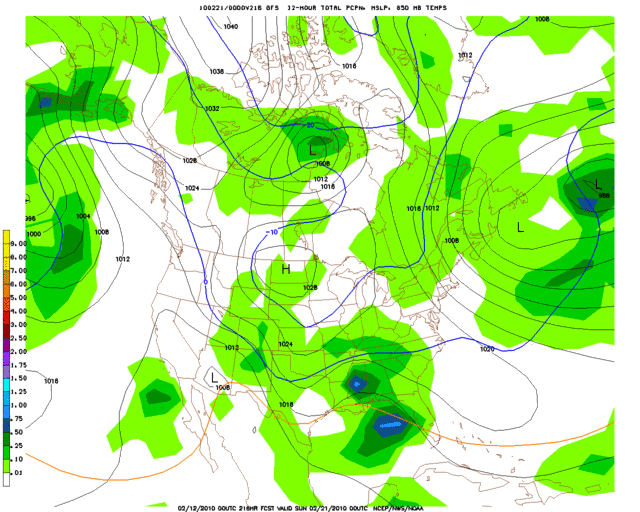
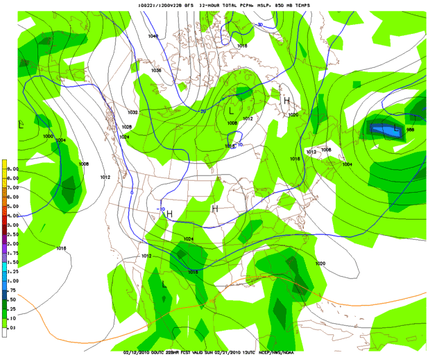
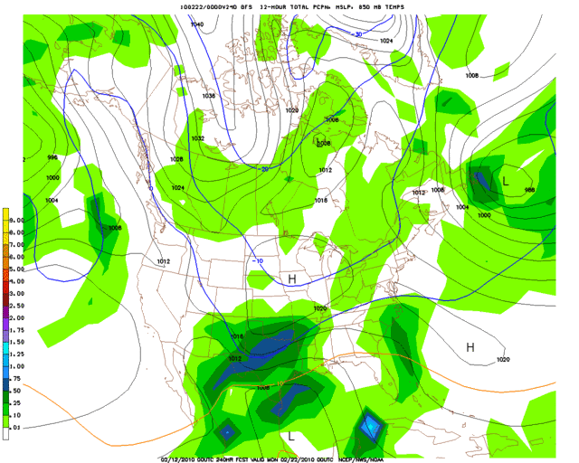
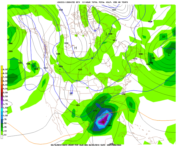
As for a system around the 25th, it is really way too far out to tell right now. The 18z GFS does show an impressive storm around the 21st/22nd ( http://www.nco.ncep.noaa.gov/pmb/nwprod ... p_252l.gif ), but being 10 days out I am inclined not to buy into it just yet. If we see model consistency increase as we draw nearer to that time frame though, then it might be something to take note of.
0 likes   

User avatar
srainhoutx
S2K Supporter
S2K Supporter
Posts: 6919
Age: 66
Joined: Sun Jan 14, 2007 11:34 am
Location: Haywood County, NC
Contact:

Re: Southern Plains winter wx thread (2009-2010)

#589 Postby srainhoutx » Thu Feb 11, 2010 8:49 pm

Extremeweatherguy wrote:
BlueIce wrote:Looks like our friends in Dallas got a pretty decent amount of snow out of this system. I saw reports of up to 10 inches in some areas! Looking ahead the next week it looks kind of quite, I heard one of the local TV guys talk about the potential for another strong system around the 25th. I guess we will have to wait and see.
Next week is kind of a "?" right now. Depending on what model you look at, there may or may not be a few systems to deal with. Either way though, it definitely looks like the cold will continue. A new arctic front should arrive on Sunday morning (possibly associated with a few light snow showers? http://www.nco.ncep.noaa.gov/pmb/nwprod ... p_072l.gif), followed by lows dipping back into the teens/lower 20s Sunday and Monday nights. Brr.

As for a system around the 25th, it is really way too far out to tell right now. The 18z GFS does show an impressive storm around the 21st/22nd ( http://www.nco.ncep.noaa.gov/pmb/nwprod ... p_252l.gif ), but being 10 days out I am inclined not to buy into it just yet. If we see model consistency increase as we draw nearer to that time frame though, then it might be something to take note of.

That will be the one to watch IMHO. Ensembles have been 'sniffing' this one and it will be an interesting storm if it verifies. Cold air
should not be a problem.
0 likes   
Carla/Alicia/Jerry(In The Eye)/Michelle/Charley/Ivan/Dennis/Katrina/Rita/Wilma/Ike/Harvey

Member: National Weather Association
Wx Infinity Forums
http://wxinfinity.com/index.php

Facebook.com/WeatherInfinity
Twitter @WeatherInfinity

User avatar
Extremeweatherguy
Category 5
Category 5
Posts: 11095
Joined: Mon Oct 10, 2005 8:13 pm
Location: Houston, TX

#590 Postby Extremeweatherguy » Thu Feb 11, 2010 11:39 pm

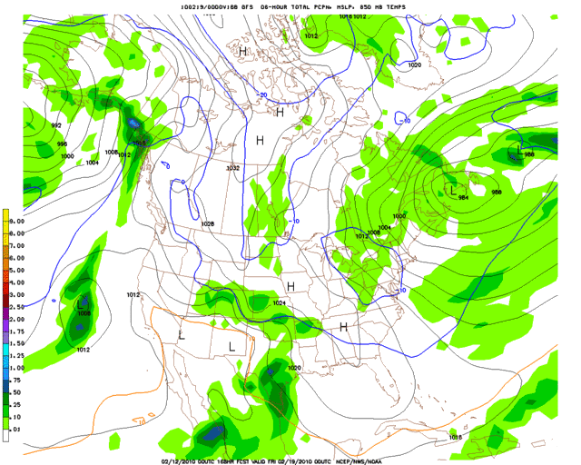
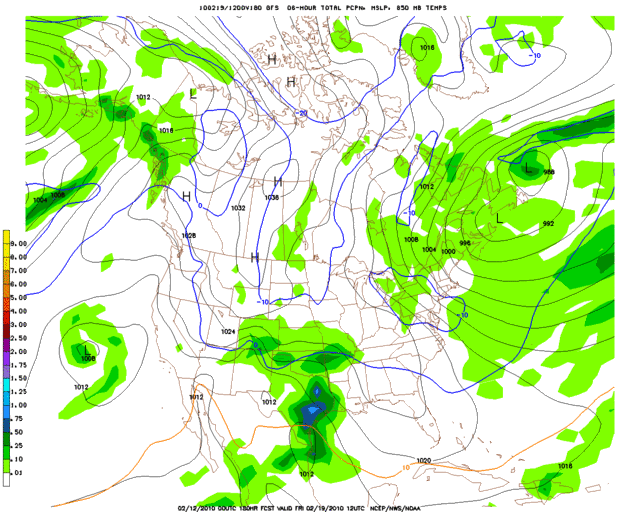
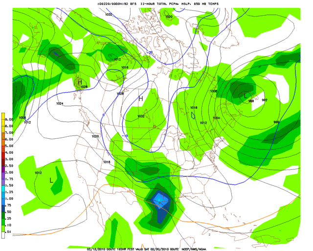
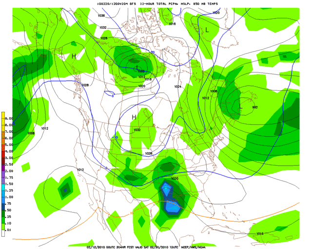
Hmm..

Image
Thurs 2/18 6pm CT

Image
Fri 2/19 6am CT

Image
Fri 2/19 6pm CT

Image
Sat 2/20 6am CT

Image
Sat 2/20 6pm CT

Image
Sun 2/21 6am CT

Image
Sun 2/21 6pm CT

Image
Mon 2/22 6am CT

This is still too far out to get worked up about just yet, but the trend of another significant winter storm around the 20th (+/- a day or two) definitely continues with tonight's 00z GFS.
0 likes   

User avatar
Extremeweatherguy
Category 5
Category 5
Posts: 11095
Joined: Mon Oct 10, 2005 8:13 pm
Location: Houston, TX

#591 Postby Extremeweatherguy » Sat Feb 13, 2010 5:07 pm

The 18z GFS is trying to put down a quick inch or two of snow across central Oklahoma tomorrow. The current NWS forecast is mainly just calling for some light snow/flurries with little to no accumulation, but it will be interesting to see if the latest GFS might be catching onto something. It is worth noting that the 18z NAM does not agree with the GFS at all and is showing 0 inches of accumulation.
0 likes   

User avatar
Extremeweatherguy
Category 5
Category 5
Posts: 11095
Joined: Mon Oct 10, 2005 8:13 pm
Location: Houston, TX

#592 Postby Extremeweatherguy » Sun Feb 14, 2010 9:42 am

Well folks, the GFS was definitely right! :eek:

I just woke up, took a peek out my window, and was shocked at what I saw! We are currently in the middle of quite a nice snow squall! Lots of wind-blown, rapidly accumulating snow coming down right now. It probably won't last long, but by the time it ends we could easily have an inch or two on the ground (which is already almost completely white).
0 likes   

User avatar
Portastorm
Storm2k Moderator
Storm2k Moderator
Posts: 9787
Age: 61
Joined: Fri Jul 11, 2003 9:16 am
Location: South Austin, TX
Contact:

Re:

#593 Postby Portastorm » Sun Feb 14, 2010 9:44 am

Extremeweatherguy wrote:Well folks, the GFS was definitely right! :eek:

I just woke up, took a peek out my window, and was shocked at what I saw! We are currently in the middle of quite a nice snow squall! Lots of wind-blown, rapidly accumulating snow coming down right now. It probably won't last long, but by the time it ends we could easily have an inch or two on the ground (which is already almost completely white).


Those are always nice surprises! Happy for you, as always, EWG! ... and dang jealous!! :ggreen:
0 likes   

User avatar
Extremeweatherguy
Category 5
Category 5
Posts: 11095
Joined: Mon Oct 10, 2005 8:13 pm
Location: Houston, TX

#594 Postby Extremeweatherguy » Sun Feb 14, 2010 9:56 am

Thanks portastorm, and hopefully you will be able to get in on the winter action over the next few weeks! I'm definitely rooting for you to get your snow! :)
0 likes   

User avatar
Extremeweatherguy
Category 5
Category 5
Posts: 11095
Joined: Mon Oct 10, 2005 8:13 pm
Location: Houston, TX

#595 Postby Extremeweatherguy » Sun Feb 14, 2010 10:41 am

And as quickly as it began, today's snow squall has ended. I haven't taken an actual measurement, but I would estimate that somewhere between 1-1.5 inches has fallen within the last hour. Pretty impressive!

UPDATE: As of 2:02pm, most of this morning's snow has melted. :( Only a few patches left.
0 likes   

User avatar
wx247
S2K Supporter
S2K Supporter
Posts: 14279
Age: 40
Joined: Wed Feb 05, 2003 10:35 pm
Location: Monett, Missouri
Contact:

#596 Postby wx247 » Sat Feb 20, 2010 1:56 pm

And it has been dead across Oklahoma, Southern Kansas, Missouri, and Arkansas since this event. Ha ha
0 likes   
Personal Forecast Disclaimer:
The posts in this forum are NOT official forecast and should not be used as such. They are just the opinion of the poster and may or may not be backed by sound meteorological data. They are NOT endorsed by any professional institution or storm2k.org. For official information, please refer to the NHC and NWS products.

Ntxw
Storm2k Moderator
Storm2k Moderator
Posts: 21494
Joined: Wed Oct 21, 2009 6:34 pm
Location: DFW, Texas

#597 Postby Ntxw » Sat Feb 20, 2010 1:57 pm

It should pick up soon, March is when the pattern shifts a bit more north and the most prolific snows occur in the northern parts of the southern plains :wink:
0 likes   
The above post and any post by Ntxw is NOT an official forecast and should not be used as such. It is just the opinion of the poster and may or may not be backed by sound meteorological data. It is NOT endorsed by any professional institution including Storm2k. For official information, please refer to NWS products.

  Help support Storm2K!
Help Support Storm2K

User avatar
Extremeweatherguy
Category 5
Category 5
Posts: 11095
Joined: Mon Oct 10, 2005 8:13 pm
Location: Houston, TX

Re:

#598 Postby Extremeweatherguy » Sat Feb 20, 2010 4:16 pm

wx247 wrote:And it has been dead across Oklahoma, Southern Kansas, Missouri, and Arkansas since this event. Ha ha
yeah, I know. lol

It looks like things might get interesting again in about 7-10 days according to the models, but it is still a little too early to get worked up about anything specific just yet. I do think we will see at least one more decent winter event before spring sets in though.
0 likes   

User avatar
Extremeweatherguy
Category 5
Category 5
Posts: 11095
Joined: Mon Oct 10, 2005 8:13 pm
Location: Houston, TX

#599 Postby Extremeweatherguy » Sat Feb 20, 2010 7:01 pm

:uarrow:

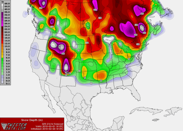
The 18z GFS is giving us a small hint of where we might be headed in 7-10 days..

Image
0 likes   

Ntxw
Storm2k Moderator
Storm2k Moderator
Posts: 21494
Joined: Wed Oct 21, 2009 6:34 pm
Location: DFW, Texas

#600 Postby Ntxw » Sat Feb 20, 2010 7:09 pm

:uarrow: That's a pretty amazing amount of snow cover as a whole for the country in March! What a winter it has been and continues to be.
0 likes   
The above post and any post by Ntxw is NOT an official forecast and should not be used as such. It is just the opinion of the poster and may or may not be backed by sound meteorological data. It is NOT endorsed by any professional institution including Storm2k. For official information, please refer to NWS products.


  Help support Storm2K!

Help Support Storm2K


Return to “Winter Weather”

Who is online

Users browsing this forum: No registered users and 96 guests