Winter 2010-11 for the Southern Plains

Winter Weather Discussion

Moderator: S2k Moderators

Forum rules

The posts in this forum are NOT official forecast and should not be used as such. They are just the opinion of the poster and may or may not be backed by sound meteorological data. They are NOT endorsed by any professional institution or STORM2K.

Help Support Storm2K
Message
Author
natecast
Tropical Low
Tropical Low
Posts: 18
Joined: Mon Jan 31, 2011 7:58 pm
Location: NW OKC/Edmond

#881 Postby natecast » Tue Feb 01, 2011 5:16 pm

Hey guys! Just got approved to post!

I live on the NW side of OKC/Edmond, and estimate I received 10-11" of snow, which I'm very happy with, considering I had forecasted 6-10", and there was supposed to be a very sharp cutoff in snow totals from W to E.

I've got a 3 foot snowdrift against the fence in our backyard. I would like to post pics but am not quite sure how to use Imageshack.

With the fresh snow cover, our forecasted low in Edmond is 2 below zero tonight! High tomorrow of 12, and low tomorrow night of 4 below zero! :cold: :cold:
0 likes   

User avatar
PTPatrick
Category 5
Category 5
Posts: 1827
Joined: Sat Jun 12, 2004 8:38 am

Re: Winter 2010-11 for the Southern Plains

#882 Postby PTPatrick » Tue Feb 01, 2011 5:31 pm

Thought you other southern plains folks might be interested in this. Apparently EURO and GFS ensembles are agreeing on another monster canadian high dropping down next week...1059 mb :eek: I know we arent done with this cold yet, but dont he bad ones come in one reinforcing wave after another?

.LONG TERM...FRIDAY THROUGH NEXT TUESDAY...LONG TERM MODELS IN
REASONABLE AGREEMENT THROUGH THE WEEKEND...WITH SOME DIFFERENCES
EARLY NEXT WEEK REGARDING THE POSSIBILITY OF A STRONG ARCTIC
OUTBREAK ACROSS THE AREA. ALL MODELS SHOW NORTHWEST TO NORTHERLY
FLOW OVER THE AREA WITH TEMPS MODERATING TO NEAR NORMAL AND HIGH
TEMPS FRIDAY AND SATURDAY IN THE 30S TO LOW 40S. WITH A FEW WEAK
DISTURBANCE PUSHING ACROSS THE AREA AND A 100KT JET ALOFT...CAN
NOT RULE OUT BANDS OF SNOW SHOWERS THROUGH SATURDAY. BY
SUNDAY...GFS AND DGEX SHOW A STRONG ARCTIC FRONT PUSHING SOUTHWARD
OUT OF CANADA BRINGING MORE SNOWFALL AND BITTER COLD TEMPS WITH
700MB TEMPS LOWERING TO -25C ACROSS THE HIGH PLAINS FOR SUNDAY AND
MONDAY. THE ECMWF HOWEVER SHOWS THE ARCTIC FRONT ABOUT 24 HOURS
LATER COMPARED TO THE OTHER MODELS...BUT THE ECMWF SHOWS THE
ARCTIC HIGH FURTHER TO THE WEST WITH THE FRONT PRODUCING MODERATE
SNOW ACCUMULATIONS ACROSS MOST OF SOUTHEAST WYOMING AND WESTERN
NEBRASKA ON MONDAY AND MONDAY NIGHT. ECMWF ALSO SHOWS AN
IMPRESSIVE 1059 MB ARCTIC SURFACE HIGH PUSHING SOUTHWARD INTO
MONTANA AND WYOMING BY TUESDAY...WITH 700 MB TEMPS PLUMMETING TO
UNDER -30C AND 850 TEMPS AROUND -25C...WHICH TRANSLATES TO
WIDESPREAD BELOW ZERO TEMPS AT THE SURFACE AND MORE DANGEROUS WIND
CHILL CONCERNS. WILL HAVE TO MONITOR THIS SYSTEM CAREFULLY OVER
THE NEXT FEW DAYS SINCE THE MAJORITY OF THE GFS ENSEMBLES AGREE
WITH THE 12Z ECMWF RUN.
FOR NOW...INCREASED POP THROUGH THE
WEEKEND AND INTO EARLY NEXT WEEK WITH LIKELY PROBABILITIES
CONFINED TO THE MOUNTAINS. WITH THE DIFFERENCES IN TIMING OF THE
FRONT...KEPT POP IN THE 25 TO 45 PCT RANGE FOR THE LOWER
ELEVATIONS BUT BELIEVE EVEN THESE AREAS HAVE A VERY GOOD CHANCE OF
SEEING SNOWFALL SOMETIME DURING THE WEEKEND AND EARLY NEXT WEEK.
LOWERED TEMPS BELOW CONSENSUS SINCE HIGHS AND LOWS APPEARED TO BE
WAY TOO WARM CONSIDERING ALL MODELS SHOW AN ARCTIC AIRMASS OVER
THE AREA EARLY NEXT WEEK. ALTHOUGH FORECAST TEMPS ARE IN THE TEENS
FOR HIGHS ON MONDAY AND TUESDAY...THEY COULD VERY WELL BE 20 DEGS
BELOW THESE VALUES IF THE ECMWF VERIFIES. &&
0 likes   

User avatar
Extremeweatherguy
Category 5
Category 5
Posts: 11095
Joined: Mon Oct 10, 2005 8:13 pm
Location: Houston, TX

#883 Postby Extremeweatherguy » Tue Feb 01, 2011 6:59 pm

Yeah, not only more cold, but it looks like we could get a little more snow to start next week too:

http://www.nco.ncep.noaa.gov/pmb/nwprod ... n_144l.gif

In the short term though, the big story here is the cold. My forecast low tonight is -1F and tomorrow night it is -4F. If these values verify, then it will be the coldest weather this area has seen since Feb 1996. Some parts of Oklahoma (N/NE sections) could even see temperatures as cold as -10F to -12F before it is all said and done. That's ridiculous!
0 likes   

Ntxw
Storm2k Moderator
Storm2k Moderator
Posts: 21501
Joined: Wed Oct 21, 2009 6:34 pm
Location: DFW, Texas

Re: Winter 2010-11 for the Southern Plains

#884 Postby Ntxw » Tue Feb 01, 2011 9:07 pm

Pretty serious for eastern half of Oklahoma.

BULLETIN - EAS ACTIVATION REQUESTED
CIVIL EMERGENCY MESSAGE
OKLAHOMA DEPARTMENT OF EMERGENCY MANAGEMENT
RELAYED BY NATIONAL WEATHER SERVICE TULSA OK
749 PM CST TUE FEB 1 2011

THE FOLLOWING MESSAGE IS TRANSMITTED AT THE REQUEST OF THE
OKLAHOMA DEPARTMENT OF EMERGENCY MANAGEMENT.

THIS IS CIVIL EMERGENCY MESSAGE FOR ANYONE STRANDED IN THEIR
VEHICLE WHO NEEDS HELP DUE TO TODAYS WINTER STORM. IN ORDER TO
ENSURE AUTHORITIES ARE AWARE OF YOUR LOCATION CALL 9 1 1 ... STAR
55 ... OR 1 800 800 2 4 8 1 ... ONCE AGAIN ... 9 1 1 ... STAR 55
... OR 1 800 800 2 4 8 1. TELL THE OPERATOR YOUR LOCATION ...
INCLUDING HIGHWAY MILE MARKER ALONG WITH VEHICLE MAKE AND THE
NUMBER OF PEOPLE IN YOUR CAR. THIS WILL ASSIST EMERGENCY PERSONNEL
IN FINDING YOU.

IF YOU ARE STRANDED...IT IS IMPERATIVE THAT YOU STAY WITH YOUR
VEHICLE. CONSERVE FUEL... USE ONLY ENOUGH TO STAY WARM. USE YOUR
HAZARD LIGHTS PERIODICALLY. CHECK EXHAUST PIPE REGULARLY TO ENSURE
IT IS NOT BLOCKED BY SNOW OR OTHER DEBRIS IN ORDER TO DECREASE THE
RISK OF CARBON MONOXIDE POISONING. TIE A COLORED CLOTH TO YOUR
VEHICLES ANTENNAE IF POSSIBLE TO HELP FIRST RESPONDERS IN LOCATING
YOU.

IF YOU TWITTER... YOU CAN TWEET THE ABOVE INFORMATION TO @OKEM ...
ONCE AGAIN THAT IS @OKEM. YOU CAN ALSO TEXT A FAMILY MEMBER AND
HAVE THEM RELAY YOUR LOCATION TO ONE OF THE ABOVE NUMBERS.
0 likes   
The above post and any post by Ntxw is NOT an official forecast and should not be used as such. It is just the opinion of the poster and may or may not be backed by sound meteorological data. It is NOT endorsed by any professional institution including Storm2k. For official information, please refer to NWS products.

  Help support Storm2K!
Help Support Storm2K

natecast
Tropical Low
Tropical Low
Posts: 18
Joined: Mon Jan 31, 2011 7:58 pm
Location: NW OKC/Edmond

Re: Winter 2010-11 for the Southern Plains

#885 Postby natecast » Thu Feb 03, 2011 11:57 am

Wow. 12Z GFS shows potential for another snowstorm in Oklahoma next Wed/Thur. This is the first time it has latched onto someting big, so we'll see if it continues to show in future runs. Right now the model output shows around 6" in and around the OKC metro.
0 likes   

User avatar
Extremeweatherguy
Category 5
Category 5
Posts: 11095
Joined: Mon Oct 10, 2005 8:13 pm
Location: Houston, TX

Re: Winter 2010-11 for the Southern Plains

#886 Postby Extremeweatherguy » Thu Feb 03, 2011 1:13 pm

I am really amazed by this pattern we are in. The cold and snow chances don't look to be going anywhere soon.

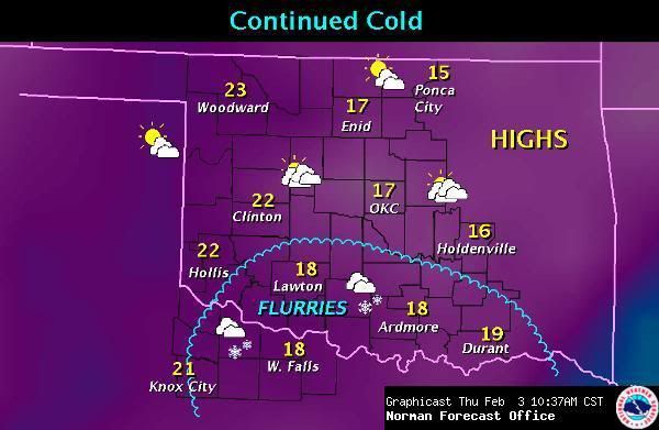
The NWS has flurries in the forecast for parts of the state today:

Image

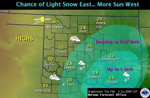
and then it looks like some spots could see light accumulations tomorrow:

Image

This is all on top of the snow from the last storm, which has not melted at all with temperatures staying well below freezing.

Check out the consecutive hours below freezing so far:

Image

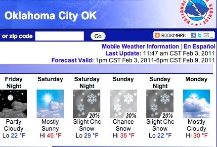
It looks like we might warm into the 40s on Saturday, if lucky, and that might help with some melting. However, right on the heels of this "warm up" comes another big chill, with highs early next week dropping back below freezing with more chances of snow!

Image

And just beyond the above forecast (around Tues/Wed/Thu), could be an even bigger snowstorm as natecast mentioned above, perhaps dropping another several inches of snow across the region.

This is just crazy..
0 likes   

BlueIce
S2K Supporter
S2K Supporter
Posts: 194
Age: 35
Joined: Mon Sep 01, 2008 10:05 pm
Location: Oklahoma City, Oklahoma

Re: Winter 2010-11 for the Southern Plains

#887 Postby BlueIce » Thu Feb 03, 2011 3:18 pm

Extremeweatherguy wrote:I am really amazed by this pattern we are in. The cold and snow chances don't look to be going anywhere soon.

The NWS has flurries in the forecast for parts of the state today:


and then it looks like some spots could see light accumulations tomorrow:


This is all on top of the snow from the last storm, which has not melted at all with temperatures staying well below freezing.

Check out the consecutive hours below freezing so far:


It looks like we might warm into the 40s on Saturday, if lucky, and that might help with some melting. However, right on the heels of this "warm up" comes another big chill, with highs early next week dropping back below freezing with more chances of snow!


And just beyond the above forecast (around Tues/Wed/Thu), could be an even bigger snowstorm as natecast mentioned above, perhaps dropping another several inches of snow across the region.

This is just crazy..


Ya check out the what the NWS is saying.

Image
0 likes   

User avatar
TwisterFanatic
Category 5
Category 5
Posts: 1041
Joined: Mon Jun 28, 2010 12:43 pm
Location: Sallisaw, Oklahoma

#888 Postby TwisterFanatic » Thu Feb 03, 2011 3:19 pm

Geez, this pattern is crazy. Snow after snow chances. I got a 60% chance tomorrow.
0 likes   
Personal Forecast Disclaimer:
The posts in this forum are NOT official forecast and should not be used as such. They are just the opinion of the poster and may or may not be backed by sound meteorological data. They are NOT endorsed by any professional institution or storm2k.org. For official information, please refer to the NHC and NWS products.

User avatar
Extremeweatherguy
Category 5
Category 5
Posts: 11095
Joined: Mon Oct 10, 2005 8:13 pm
Location: Houston, TX

Re: Winter 2010-11 for the Southern Plains

#889 Postby Extremeweatherguy » Thu Feb 03, 2011 3:43 pm

000
FXUS64 KOUN 032038
AFDOUN

AREA FORECAST DISCUSSION
NATIONAL WEATHER SERVICE NORMAN OK
238 PM CST THU FEB 3 2011

.DISCUSSION...
UPPER LOW OVER SOUTHERN NM/NORTHERN OLD MEXICO WILL MOVE EAST
ACROSS THE SOUTHERN PLAINS TONIGHT AND FRIDAY. THIS SYSTEM HAS
BROUGHT MID-LEVEL CLOUDS TO PARTS OF THE FA WHICH ARE EXPECTED TO
PERSIST OVERNIGHT INTO FRIDAY. WITH THE CLOUD COVER TEMPERATURES
TONIGHT WILL REMAIN SLIGHTLY WARMER THAN LAST NIGHT IN MANY
LOCATIONS. HOWEVER... WILL STILL BE COLD WITH LOWS RANGING FROM
AROUND ZERO IN THE NORTH TO THE LOW TEENS ALONG THE RED RIVER. THE
UPPER LOW WILL ALSO BRING A CHANCE OF LIGHT SNOW OR SNOW FLURRIES
TO APPROXIMATELY THE SOUTHEAST HALF OF THE FA BY FRIDAY. SOME
ACCUMULATIONS WILL BE POSSIBLE. HOWEVER... THESE ARE NOT EXPECTED
TO BE LARGE WITH THE GREATEST AMOUNTS... MAYBE UP TO AN INCH...
EXPECTED IN SE PORTIONS OF THE FA. TEMPERATURES WILL CONT TO
GRADUALLY WARM FRIDAY AND SATURDAY WITH MOST PLACES EXPECTED TO
CLIMB ABOVE FREEZING SATURDAY.

NW FLOW ALOFT WILL AFFECT THE SOUTHERN PLAINS THIS WEEKEND INTO
EARLY NEXT WEEK. MODELS SHOW SEVERAL DISTURBANCES THAT WILL MOVE
THROUGH THIS FLOW... BRINGING SEVERAL CHANCES FOR LIGHT SNOW/SNOW
FLURRIES SAT NIGHT THROUGH SUNDAY NIGHT. SNOW ACCUMULATIONS OF AN
INCH OR TWO WILL BE POSSIBLE IN SOME LOCATIONS BY MONDAY BUT NO
SIGNIFICANT PRECIP IS EXPECTED. A COLD FRONT WILL ALSO MOVE ACROSS
THE REGION SUNDAY BRINGING ANOTHER ROUND OF COLD AIR THAT WILL
CONTINUE INTO THE MIDDLE OF NEXT WEEK.

MORE SIGNIFICANT WINTER PRECIPITATION MAY BE POSSIBLE TUESDAY AND
WEDNESDAY. MODELS SHOW A SHORTWAVE MOVING SE TOWARDS THE SOUTHERN
PLAINS TUESDAY THEN MOVING ACROSS THE REGION WEDNESDAY. RIGHT NOW
THIS SYSTEM DOES NOT LOOK AS STRONG AS THE ONE FROM EARLIER THIS
WEEK. HOWEVER... THE SYSTEM COULD STILL PRODUCE SEVERAL INCHES OF
SNOW IN SOME LOCATIONS ALONG WITH GUSTY WINDS AND COLD WIND CHILLS.
BEING SIX TO SEVEN DAYS AWAY MANY THINGS CAN CHANGE BUT RIGHT NOW
TUESDAY AND WEDNESDAY LOOKS LIKE THE NEXT CHANCE FOR IMPACTFUL SNOW
ACCUMULATIONS IN PARTS OF THE FA.


BTW: The "warm" day in the 40s that was expected for Saturday has been revised downward. The new forecast calls for a high of just 39F in Oklahoma City.
0 likes   

natecast
Tropical Low
Tropical Low
Posts: 18
Joined: Mon Jan 31, 2011 7:58 pm
Location: NW OKC/Edmond

Re: Winter 2010-11 for the Southern Plains

#890 Postby natecast » Thu Feb 03, 2011 8:27 pm

18Z run of the GFS doesn't look as favorable for snow across OK on Tue/Wed as the 12Z run did, but I wouldn't concern myself with run to run differences this far out. The thing to note, however, is that the upper-air pattern looks very favorable for a significant winter storm developing somewhere in the southern tier of the country. It looks like someone's going to be in for quite a doozy towards the middle to end of next week.
0 likes   

User avatar
SouthernMet
Category 3
Category 3
Posts: 857
Joined: Sun Aug 29, 2010 8:23 pm
Location: fort worth, tx

Re: Winter 2010-11 for the Southern Plains

#891 Postby SouthernMet » Thu Feb 03, 2011 8:28 pm

A widespread signifigant winter weather event may be on tap for the Southern Plains next week. Maybe a weaker system monday, followed by a potential major storm towards wednesday or the middle of the week. Here we go again stay tuned as they say... :flag:
0 likes   
Nothing that SouthernMet posts, is an official forecast,nor does it reflect views of STORM2K.. SouthernMet is just adding to the great discussions on STORM2K.. Refer to NWS for official forecasts.

natecast
Tropical Low
Tropical Low
Posts: 18
Joined: Mon Jan 31, 2011 7:58 pm
Location: NW OKC/Edmond

Re: Winter 2010-11 for the Southern Plains

#892 Postby natecast » Thu Feb 03, 2011 8:34 pm

SouthernMet wrote:A widespread signifigant winter weather event may be on tap for the Southern Plains next week. Maybe a weaker system monday, followed by a potential major storm towards wednesday or the middle of the week. Here we go again stay tuned as they say... :flag:


You're right, SouthernMet. The Southern Plains does appear to be in for it again next week. Didn't mean to single out OK in my last post, especially considering the title of the thread!
0 likes   

natecast
Tropical Low
Tropical Low
Posts: 18
Joined: Mon Jan 31, 2011 7:58 pm
Location: NW OKC/Edmond

Re: Winter 2010-11 for the Southern Plains

#893 Postby natecast » Fri Feb 04, 2011 9:45 am

We've got moderate snow falling in OKC, with a temp of 20. Winter Weather Advisory just issued by the NWS for around 2" of accumulation. I was only expecting a dusting out of this, so a little bit of a sneak attack here.

At least this round isn't blowing sideways like the blizzard. Nice, gentle, snowfall. :D
0 likes   

User avatar
TwisterFanatic
Category 5
Category 5
Posts: 1041
Joined: Mon Jun 28, 2010 12:43 pm
Location: Sallisaw, Oklahoma

#894 Postby TwisterFanatic » Fri Feb 04, 2011 10:38 am

I have a HEAVY band set up over my area right now and have gotten 3.5 inches from just this storm with it still coming down hard.
0 likes   
Personal Forecast Disclaimer:
The posts in this forum are NOT official forecast and should not be used as such. They are just the opinion of the poster and may or may not be backed by sound meteorological data. They are NOT endorsed by any professional institution or storm2k.org. For official information, please refer to the NHC and NWS products.

User avatar
Extremeweatherguy
Category 5
Category 5
Posts: 11095
Joined: Mon Oct 10, 2005 8:13 pm
Location: Houston, TX

#895 Postby Extremeweatherguy » Fri Feb 04, 2011 10:52 am

Yeah, so much for that dusting (at best) today. I already have that, and based on radar trends, it looks like today could easily total an additional 1-3 inches around here; especially as you head south and east from OKC.
0 likes   

kmc8264
Tropical Low
Tropical Low
Posts: 21
Joined: Thu Jan 27, 2011 7:42 pm

#896 Postby kmc8264 » Fri Feb 04, 2011 11:12 am

How is it looking for snow accumulations for southwest ok next week? There are a lot of schools that need to get back in session.
0 likes   

natecast
Tropical Low
Tropical Low
Posts: 18
Joined: Mon Jan 31, 2011 7:58 pm
Location: NW OKC/Edmond

Re:

#897 Postby natecast » Fri Feb 04, 2011 12:58 pm

kmc8264 wrote:How is it looking for snow accumulations for southwest ok next week? There are a lot of schools that need to get back in session.


It looks like SW/S OK & NW TX could receive 2-4" of snow during the day on Sunday.
0 likes   

User avatar
TwisterFanatic
Category 5
Category 5
Posts: 1041
Joined: Mon Jun 28, 2010 12:43 pm
Location: Sallisaw, Oklahoma

#898 Postby TwisterFanatic » Fri Feb 04, 2011 1:00 pm

Winter Storm Warnings for all of Eastern Oklahoma.
0 likes   
Personal Forecast Disclaimer:
The posts in this forum are NOT official forecast and should not be used as such. They are just the opinion of the poster and may or may not be backed by sound meteorological data. They are NOT endorsed by any professional institution or storm2k.org. For official information, please refer to the NHC and NWS products.

kmc8264
Tropical Low
Tropical Low
Posts: 21
Joined: Thu Jan 27, 2011 7:42 pm

Re: Winter 2010-11 for the Southern Plains

#899 Postby kmc8264 » Fri Feb 04, 2011 1:09 pm

Thanks, we could handle that as long as it didn't drift. Our rural buses don't do too well in drifts. What do you think about Wed?
0 likes   

natecast
Tropical Low
Tropical Low
Posts: 18
Joined: Mon Jan 31, 2011 7:58 pm
Location: NW OKC/Edmond

Re: Winter 2010-11 for the Southern Plains

#900 Postby natecast » Fri Feb 04, 2011 1:50 pm

kmc8264 wrote:Thanks, we could handle that as long as it didn't drift. Our rural buses don't do too well in drifts. What do you think about Wed?


Wed is a difficult forecast, with many varying model solutions. Right now I would call for 1-3" in your area.
0 likes   


Return to “Winter Weather”

Who is online

Users browsing this forum: No registered users and 214 guests