Clearwater is now down to 34F at 11pm with a dewpoint of 31F; definitely seems like a freeze warning should have been issued there. They had one last night and never got below 40F.
Other 11pm readings across central FL include 38F at Orlando International, 32F in Daytona Beach, and 31F at Cape Canaveral. Pretty chilly readings for it not even being midnight yet..
Florida winter thread 2010-11
Moderator: S2k Moderators
Forum rules
 The posts in this forum are NOT official forecast and should not be used as such. They are just the opinion of the poster and may or may not be backed by sound meteorological data. They are NOT endorsed by any professional institution or STORM2K.

The posts in this forum are NOT official forecast and should not be used as such. They are just the opinion of the poster and may or may not be backed by sound meteorological data. They are NOT endorsed by any professional institution or STORM2K.
-
Extremeweatherguy

- Category 5

- Posts: 11095
- Joined: Mon Oct 10, 2005 8:13 pm
- Location: Houston, TX
clearwater read rather warm last night and tonight the opposite appears to be taking place with the airport reading lower than tpa...it seems a bit anomalous as i am directly north of the airport and usually read cooler than that location but i have 39. the criteria for freeze warnings for the ruskin cwa is 3 or more hours below freezing...something that probably won't occur over the vast majority of pinellas sans perhaps the eastlake/brooker creek preserve area hence the lack of a freeze warning for pinellas. that said i do expect widespread frost as we had this morning.
0 likes
it is quite chilly out there tonight. down to 35 with some frost sparkling on car tops and grass in open areas. it is dead calm, the sky is clear and starry and there is a pall of smoke blanketing us from all the wood burning fireplaces in use. i feel like i'm back north! and as much as i have been enjoying my fireplace on these cold nights...i can't wait to say it's too warm for a fire tonight. december is destined to ge down as a very cold month despite the upcoming balmy new year's eve temps.
0 likes
-
gatorcane

- S2K Supporter

- Posts: 23499
- Age: 46
- Joined: Sun Mar 13, 2005 3:54 pm
- Location: Boca Raton, FL
St. Pete Clearwater airport is 33f as of 12am eastern.
I wonder if the nws night crew will go with a freeze warning for central and northern pinellas?
Curiously, Tampa international is at 38f. Usually it's colder there than in pinellas. Could the thermometer be having an issue at St. Pete Clearwater?
But, according to nws Miami mesoscale analysis, there is indeed a pocket of 32f temps in northern pinellas as of 11pm eastern.
http://www.srh.noaa.gov/mfl/analysis/?type=T
Looks like there will be some damage to freeze intolerant vegetation across northern and central pinellas this time, though during the last freeze, it was mostly spared.
0 likes
don't think they'll go with a freeze warning for pinellas. freeze warnings are county wide things and the preponderance prevails. most of the county won't freeze but some spots will...and those folks know who they are. there's no freeze warning for lee county either but folks with sensitive vegetation in lehigh acres who don't take precautions do so at their own peril. it works in reverse too. manatee county has a freeze warning but folks on anna maria have no fear... again, it is a preponderance thing... the majority of the county will freeze so it gets a freeze warning. i don't doubt the thermometer there (at st pete clearwater). if anything this morning's relatively balmy low seemed more strange as i observed plenty of frost on the way to work today in that very area after 9 am. sometimes strange things happen in a dead still night with good radiational cooling. the difference between a light freeze and some frosty conditions that don't quite meet freeze criteria is negligible, particularly in light of the recent cold weather.
0 likes
-
JonathanBelles
- Professional-Met

- Posts: 11430
- Age: 33
- Joined: Sat Dec 24, 2005 9:00 pm
- Location: School: Florida State University (Tallahassee, FL) Home: St. Petersburg, Florida
- Contact:
-
FLCrackerGirl

- S2K Supporter
- Posts: 49
- Joined: Tue Jun 30, 2009 10:53 pm
- Location: Vero Beach, Florida
29°F at 3am in Vero Beach. Freezing, Fog & Smoke, Yuck!
Brevard & Indian River Counties also under a Dense Smoke Warning from the 13000 acres fire at Three Forks Marsh Conservation Area, southwest of Palm Bay.
from nws melbourne:
... smoke has mixed with fog. The Florida Highway patrol reports Road closures to to the dense smoke and fog in extreme southern Brevard and Indian River counties.
The latest reports indicate Interstate 95 is closed from southern Brevard County at Malabar Road... or exit 173 south into northern Indian River County at State Road 512... or exit 160. Additional Road closures will be possible in southern Brevard and northern Indian River counties this morning. A light westerly wind is
allowing the smoke to drift toward the east... with hazardous visibility reductions being reported all the way to the coast.
from nws mlb conditions blog: robust heat signature on satellite
http://www.srh.noaa.gov/images/fxc/mlb/101229_0011.gif
fire clutter also visible on radar
http://radar.weather.gov/radar.php?rid=mlb
0 likes
-
Extremeweatherguy
- Category 5
- Posts: 11095
- Joined: Mon Oct 10, 2005 8:13 pm
- Location: Houston, TX
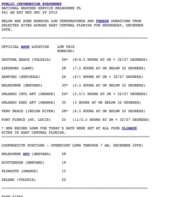
Florida low temperatures this morning (based on the latest info available)...
≤32F highlighted in light blue
≤27F highlighted in dark blue
≤22F highlighted in pink
West Palm Beach = 43F
Miami = 50F
Fort Myers = 37F
Key West = 54F
Orlando (MCO) = 24F
Orlando (Executive) = 30F
Sanford = 26F
Tampa = 34F
Brooksville = 17F
Plant City = 27F
Okeechobee County Airport = 32F
Melbourne = 30F
Daytona Beach = 26F
Ocala = 21F
Jacksonville (Intl. airport) = 26F
Tallahassee = 22F
Last edited by Extremeweatherguy on Wed Dec 29, 2010 10:26 am, edited 1 time in total.
0 likes
-
Extremeweatherguy
- Category 5
- Posts: 11095
- Joined: Mon Oct 10, 2005 8:13 pm
- Location: Houston, TX

Re: Florida winter thread 2010-11
The morning of the 28th, I recorded the coldest temp I've seen in West Broward (Sawgrass Mills area) since I've had the thermometer 7 years ago. It was 25.8 degrees at 6:30 AM and all the cars in the parking lot were frozen over, completely covered in ice 1/4 inch thick from windshields to roofs and even the exhaust pipes. Many bushes also were coated in ice, it looked like a winter wonderland! One of the most fascinating aspects were the patterns made by the frost on the windshields!


Uploaded with ImageShack.us
Last night (29th early AM) the low temp here was 36 degrees at 1 AM, then the NE winds kicked in and rose it to 40 by 3 AM.


Uploaded with ImageShack.us
Last night (29th early AM) the low temp here was 36 degrees at 1 AM, then the NE winds kicked in and rose it to 40 by 3 AM.
0 likes
Georges '98, Irene '99, Frances '04, Jeanne '04, Katrina '05, Wilma '05, Gustav '08, Isaac '12, Matthew '16, Florence '18, Michael '18, Ian '22

-
northjaxpro

- S2K Supporter
- Posts: 8900
- Joined: Mon Sep 27, 2010 11:21 am
- Location: Jacksonville, FL
It is 31.2 degrees at 7:15 a.m. This is the 19th day this month that the temperature has reached or dipped below the freezing mark, which is just absolutely amazing. As already discussed, this has been the coldest December ever on record here in Jax and the peninsula in general. We have already surpassed the average total of number of freezes in an entire winter season here in Jax, which is 18.
0 likes
NEVER, EVER SAY NEVER in the tropics and weather in general, and most importantly, with life itself!!
________________________________________________________________________________________
Fay 2008 Beryl 2012 Debby 2012 Colin 2016 Hermine 2016 Julia 2016 Matthew 2016 Irma 2017 Dorian 2019
________________________________________________________________________________________
Fay 2008 Beryl 2012 Debby 2012 Colin 2016 Hermine 2016 Julia 2016 Matthew 2016 Irma 2017 Dorian 2019

Re: Florida winter thread 2010-11
I think were done with the cold fronts for awhile as the pattern is flipping to what La Nina is supposed to do here in Florida.
0 likes
-
HURRICANELONNY
- Category 5
- Posts: 1381
- Joined: Wed May 07, 2003 6:48 am
- Location: HOLLYWOOD.FL
Re: Florida winter thread 2010-11
Hope so. Haven't looked at the long rangers. I think some posted. Possible change back in mid Jan. Have to see. HAPPY NEW YEAR EVERYONE!
Both GFS and European model (ecmwf) show the
next appreciable cold front arriving Saturday Jan 8th...but right
now they indicate only cooler conditions behind the
front...nothing "cold" like we've seen recently. Happy New Year!
Both GFS and European model (ecmwf) show the
next appreciable cold front arriving Saturday Jan 8th...but right
now they indicate only cooler conditions behind the
front...nothing "cold" like we've seen recently. Happy New Year!
0 likes
hurricanelonny
Re: Florida winter thread 2010-11
I agree. Any winter I can remember that featured a very cold December, the rest of the winter was typically not that impressive, with more garden-variety "cold fronts" interspersed with warm periods. Also, based purely on experience, after about the first 3 weeks of January, the chances of significant winter weather in S. Florida start diminishing quickly.
We've had 3 significant Arctic intrusions. Plenty of years, we don't get those numbers over the course of an entire winter. Could be one of those cases when, at least for us in South-Central Florida, winter has already shown all of its real cards.
We've had 3 significant Arctic intrusions. Plenty of years, we don't get those numbers over the course of an entire winter. Could be one of those cases when, at least for us in South-Central Florida, winter has already shown all of its real cards.
0 likes
-
HURRICANELONNY
- Category 5
- Posts: 1381
- Joined: Wed May 07, 2003 6:48 am
- Location: HOLLYWOOD.FL
Re: Florida winter thread 2010-11
HAPPY NEW YEAR!
Personally. I'm not much of a fan of the GFS this far out. Probably 10-15 degrees too cold.
The 01.00z runs of the GFS and European model (ecmwf) are in good agreement until
Fri-Sat...at which time they differ significantly on the sharpness
of a trough taking shape over the eastern Continental U.S.. GFS is much more
amplified to the south...and now shows a fairly significant cold
push down the peninsula. However...the European model (ecmwf) continues much
milder. It does appear that temperatures will go below climatology by next
weekend behind the next cold front...just how far below is the
question
Knew the GFS was full of it:
Towards the later part of the week...a middle/upper low now moving
towards California is shown by both the GFS and European model (ecmwf) to combine
with a shortwave diving out of Canada. This develops low pressure
off the middle Atlantic Thursday with a cold front moving across
South Florida late Thursday...with some showers possible. The European model (ecmwf)
continues milder compared to the GFS...though recent GFS runs have
been trending towards the European model (ecmwf). So although cooler weather will
prevail Fri-sun..."cold" weather is not anticipated.
Last edited by HURRICANELONNY on Sun Jan 02, 2011 11:16 am, edited 1 time in total.
0 likes
hurricanelonny
-
SFLcane

- S2K Supporter
- Posts: 9606
- Age: 46
- Joined: Sat Jun 05, 2010 1:44 pm
- Location: Lake Worth Florida
Re: Florida winter thread 2010-11
It does look like more colder weather for the second week of 2011, if the GFS is right. Of course, it's still pretty far out in time, but looks like a negative NAO pattern once again. The Climate Prediction Center stated in their December update that in the Jan-Mar following a highly negative NAO, 48% of those years the NAO remained mostly negative in the Jan-Mar period, which is higher than if it was a purely random signal (33%). Also, the long-range CFS model is indicating below normal temps for South Florida in January, followed by near normal in Feb and Mar. The CFS indicated below normal temps for December, which as we know verified! We'll see.
Happy New Year!!
Happy New Year!!
0 likes
Who is online
Users browsing this forum: No registered users and 83 guests