Florida winter thread 2010-11

Winter Weather Discussion

Moderator: S2k Moderators

Forum rules

The posts in this forum are NOT official forecast and should not be used as such. They are just the opinion of the poster and may or may not be backed by sound meteorological data. They are NOT endorsed by any professional institution or STORM2K.

Help Support Storm2K
Message
Author
User avatar
Extremeweatherguy
Category 5
Category 5
Posts: 11095
Joined: Mon Oct 10, 2005 8:13 pm
Location: Houston, TX

Re: Florida winter thread 2010-11

#261 Postby Extremeweatherguy » Sat Jan 01, 2011 1:55 pm

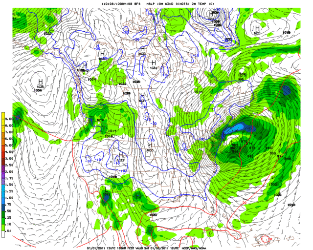
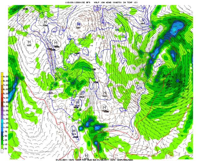
If today's 12z GFS run is correct, then there may be more freeze threats deep into peninsular Florida by this upcoming weekend..

168 HR
Image

192 HR
Image
0 likes   

User avatar
Extremeweatherguy
Category 5
Category 5
Posts: 11095
Joined: Mon Oct 10, 2005 8:13 pm
Location: Houston, TX

#262 Postby Extremeweatherguy » Sat Jan 01, 2011 2:12 pm

0 likes   

User avatar
jdray
Category 3
Category 3
Posts: 846
Joined: Tue Aug 31, 2004 10:07 pm
Location: NE Florida

Re: Florida winter thread 2010-11

#263 Postby jdray » Sun Jan 02, 2011 12:30 pm

Looking at prelimenary reports for NWS JAX, December 2010 was 8.9F colder than normal.
19 days below freezing (more than the average winter for JAX)
Only 8 days made it to 70F or above.
The average min temp was 32F for the month, average max temp was 60.3F, average temp was 46.1F

That is a cold cold month for us here in NE Florida. We are used to some cold temps, but not like it was in December.
0 likes   

Patrick99
Category 5
Category 5
Posts: 1752
Joined: Mon May 24, 2004 3:43 pm
Location: Miami, FL

Re: Florida winter thread 2010-11

#264 Postby Patrick99 » Sun Jan 02, 2011 2:49 pm

NWS Miami not too impressed with next weekend's cool shot. Which is fine....."seasonably cool" works for me:

"LONG TERM (THU-SUN)...
ZONAL FLOW BEGINS TO BUCKLE AS DEEP LOW OVER GREAT LAKES AMPLIFIES
A TROUGH OVER THE EASTERN UNITED STATES. MODELS ARE IN GOOD
AGREEMENT ON A COLD FRONT MOVING THROUGH THE STATE DURING THE LATE
THURSDAY/EARLY FRIDAY TIME FRAME, WITH NOT MUCH IN THE WAY OF
PRECIP IN ASSOCIATION WITH IT. CURRENT INDICATIONS ARE THAT TEMPERATURES
BEHIND THIS NEXT FRONT WILL FALL TO SEASONABLY...NOT UNSEASONABLY...COOL
LEVELS FOR THE END OF THE WEEK AND NEXT WEEKEND."

Good read about the S. FL temperature extremes of 2010 - I agree, it did feel like one of the coldest, and hottest, years here I've experienced. December and January were cold, and the summer was brutal.
http://www.srh.noaa.gov/images/mfl/news ... ummary.pdf
0 likes   

User avatar
NDG
S2K Supporter
S2K Supporter
Posts: 14933
Joined: Sun Jul 09, 2006 10:14 pm
Location: Orlando, FL

Re: Florida winter thread 2010-11

#265 Postby NDG » Sun Jan 02, 2011 6:09 pm

Extremeweatherguy wrote:If today's 12z GFS run is correct, then there may be more freeze threats deep into peninsular Florida by this upcoming weekend..

168 HR
Image

192 HR
Image


Glad the GFS looks to be wrong after all, no freezes for the peninsula over the next 7 days at least.
0 likes   

HURRICANELONNY
Category 5
Category 5
Posts: 1381
Joined: Wed May 07, 2003 6:48 am
Location: HOLLYWOOD.FL

#266 Postby HURRICANELONNY » Mon Jan 03, 2011 7:41 am

I don't know for sure if the GFS is totally wrong. Last cold invasion the models did something similar. There are signs that the Artic air will be back. Including a -NAO/AO. Have to wait and see what happens mid month. It might come in front after front.
0 likes   
hurricanelonny

User avatar
NDG
S2K Supporter
S2K Supporter
Posts: 14933
Joined: Sun Jul 09, 2006 10:14 pm
Location: Orlando, FL

Re:

#267 Postby NDG » Mon Jan 03, 2011 9:05 am

HURRICANELONNY wrote:I don't know for sure if the GFS is totally wrong. Last cold invasion the models did something similar. There are signs that the Artic air will be back. Including a -NAO/AO. Have to wait and see what happens mid month. It might come in front after front.


Both the NAO & AO have been negative for a while now.
I was talking about what the GFS was forecasting a couple of days ago or so of freezing temps returning to the FL Peninsula this weekend while the Euro was not doing so.
There's no model support for freezing temps to return this weekend for central/S FL.
0 likes   

HURRICANELONNY
Category 5
Category 5
Posts: 1381
Joined: Wed May 07, 2003 6:48 am
Location: HOLLYWOOD.FL

Re: Re:

#268 Postby HURRICANELONNY » Mon Jan 03, 2011 12:10 pm

NDG wrote:
HURRICANELONNY wrote:I don't know for sure if the GFS is totally wrong. Last cold invasion the models did something similar. There are signs that the Artic air will be back. Including a -NAO/AO. Have to wait and see what happens mid month. It might come in front after front.


Both the NAO & AO have been negative for a while now.
I was talking about what the GFS was forecasting a couple of days ago or so of freezing temps returning to the FL Peninsula this weekend while the Euro was not doing so.
There's no model support for freezing temps to return this weekend for central/S FL.


I think the models have the AO/NAO tanking mid month. Don't know for sure. As for this weekend. Cooler. But most likely. No freeze down here. The models are trending cooler. Have to wait and see. How much.

But the latest long range models are showing
a little bit cooler temperatures compare to earlier runs. Will
continue to monitor the trends in the long range models and if the
trend continues then will make adjustments to the weekend temperatures in
later packages.
0 likes   
hurricanelonny

User avatar
NDG
S2K Supporter
S2K Supporter
Posts: 14933
Joined: Sun Jul 09, 2006 10:14 pm
Location: Orlando, FL

Re: Re:

#269 Postby NDG » Mon Jan 03, 2011 2:27 pm

HURRICANELONNY wrote:
NDG wrote:
HURRICANELONNY wrote:I don't know for sure if the GFS is totally wrong. Last cold invasion the models did something similar. There are signs that the Artic air will be back. Including a -NAO/AO. Have to wait and see what happens mid month. It might come in front after front.


Both the NAO & AO have been negative for a while now.
I was talking about what the GFS was forecasting a couple of days ago or so of freezing temps returning to the FL Peninsula this weekend while the Euro was not doing so.
There's no model support for freezing temps to return this weekend for central/S FL.


I think the models have the AO/NAO tanking mid month. Don't know for sure. As for this weekend. Cooler. But most likely. No freeze down here. The models are trending cooler. Have to wait and see. How much.

But the latest long range models are showing
a little bit cooler temperatures compare to earlier runs. Will
continue to monitor the trends in the long range models and if the
trend continues then will make adjustments to the weekend temperatures in
later packages.


Yes, GFS ensembles have the AO tanking again in mid month but it usually takes about a week or so afterwards for FL to see the effects of it.
The next Arctic blast invading the US its core looks to have its eyes more for northern Rockies and central Plains with a SW UL flow over FL that should modify it as it reaches its 1060 mb high tentacles over FL by days 7-10 from now.
0 likes   

User avatar
northjaxpro
S2K Supporter
S2K Supporter
Posts: 8900
Joined: Mon Sep 27, 2010 11:21 am
Location: Jacksonville, FL

#270 Postby northjaxpro » Mon Jan 03, 2011 2:36 pm

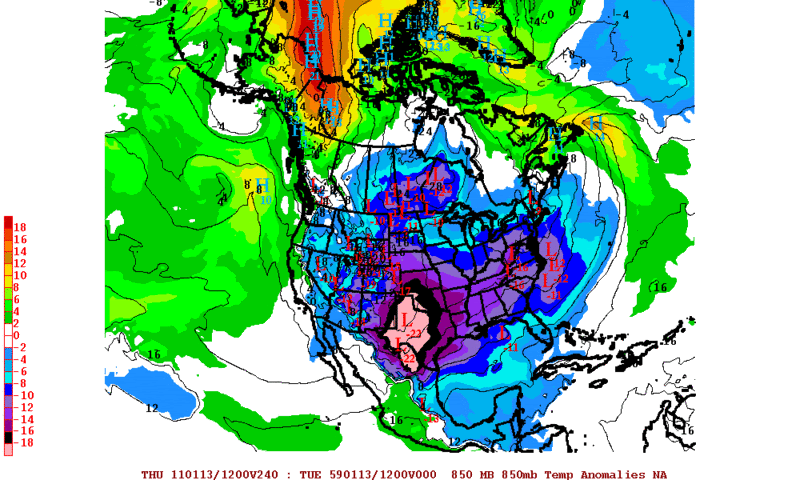
Longer range runs from the EURO and GFS are indicating major, major changes now as bitterly cold arctic air from Siberia is poised to drop southward down the Lee side of the Rockies into the Eastern 2/3 of the CONUS, icluding the Deep South and Florida.

There are indications that this upcoming arctic intrusion coming within the next 7-10 days could rival the major arctic outbreak of December 1989. This situation is being followed on two other threads. Needless to say, all of my fellow Storm2K posters here in Florida definitely need to closely monitor this situation over the course of the next week. This is a potentially serious situation for sure. This is amazing that this may occur, especially after many of us in the peninsula are just finished still trying to recover from the coldest December ever on record.

STAY TUNED!!!!
0 likes   
NEVER, EVER SAY NEVER in the tropics and weather in general, and most importantly, with life itself!!

________________________________________________________________________________________

Fay 2008 Beryl 2012 Debby 2012 Colin 2016 Hermine 2016 Julia 2016 Matthew 2016 Irma 2017 Dorian 2019

User avatar
NDG
S2K Supporter
S2K Supporter
Posts: 14933
Joined: Sun Jul 09, 2006 10:14 pm
Location: Orlando, FL

Re:

#271 Postby NDG » Mon Jan 03, 2011 2:53 pm

northjaxpro wrote:Longer range runs from the EURO and GFS are indicating major, major changes now as bitterly cold arctic air from Siberia is poised to drop southward down the Lee side of the Rockies into the Eastern 2/3 of the CONUS, icluding the Deep South and Florida.

There are indications that this upcoming arctic intrusion coming within the next 7-10 days could rival the major arctic outbreak of December 1989. This situation is being followed on two other threads. Needless to say, all of my fellow Storm2K posters here in Florida definitely need to closely monitor this situation over the course of the next week. This is a potentially serious situation for sure. This is amazing that this may occur, especially after many of us in the peninsula are just finished still trying to recover from the coldest December ever on record.

STAY TUNED!!!!
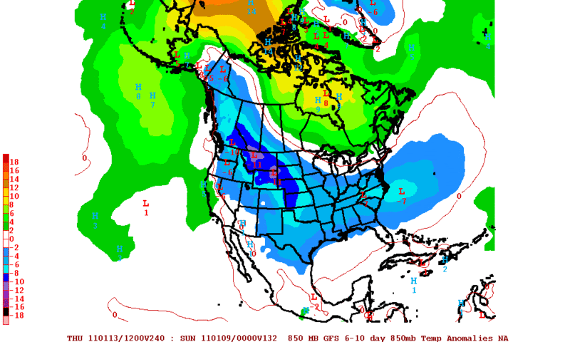

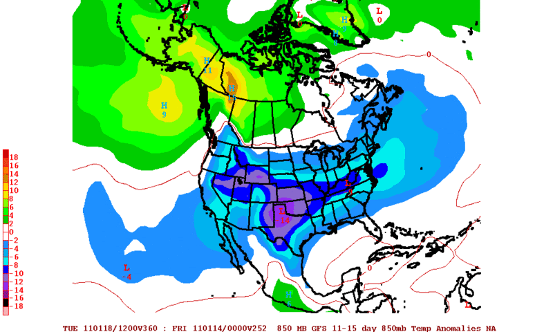
Too early to say for sure but so far both the Euro & GFS show that the core of the cold air will be flowing straight southward towards TX & parts of the gulfcoast, it does not show that FL will see the core of it like the 2 Arctic blasts back in December, at least not yet. But so far it looks like FL might be spared from the coldest of it, is TX turn this time, hopefully ;)

Euro:
Image

GFS:
Image
Image
0 likes   

User avatar
northjaxpro
S2K Supporter
S2K Supporter
Posts: 8900
Joined: Mon Sep 27, 2010 11:21 am
Location: Jacksonville, FL

#272 Postby northjaxpro » Mon Jan 03, 2011 3:01 pm

NDG, I agree it is a bit early yet to see if the models verify close to what the early runs are depicting. I think it is safe to assume that the arctic blast is coming down though. It is just a matter to what magnitude and severity. I'm with you. I am praying that we just get a "glancing blow" from this upcoming outbreak and the brunt or core of it stays north of the peninsula, especially after the record cold December we just went through. But, the jury is still out on this obviously. That is why I stated we here in the peninsula still have to monitor the trends carefully and stay tuned for the next week.
0 likes   
NEVER, EVER SAY NEVER in the tropics and weather in general, and most importantly, with life itself!!

________________________________________________________________________________________

Fay 2008 Beryl 2012 Debby 2012 Colin 2016 Hermine 2016 Julia 2016 Matthew 2016 Irma 2017 Dorian 2019

HURRICANELONNY
Category 5
Category 5
Posts: 1381
Joined: Wed May 07, 2003 6:48 am
Location: HOLLYWOOD.FL

#273 Postby HURRICANELONNY » Wed Jan 05, 2011 7:52 am

Looks like most of the freeze is west of S. Fl. after the 15th. But it is too early to say what happens then and after.
0 likes   
hurricanelonny

Patrick99
Category 5
Category 5
Posts: 1752
Joined: Mon May 24, 2004 3:43 pm
Location: Miami, FL

Re: Florida winter thread 2010-11

#274 Postby Patrick99 » Wed Jan 05, 2011 5:49 pm

Per NWS Miami:

"Y TUESDAY WITH ANOTHER STRONGER COLD FRONT EXPECTED TO MOVE
ACROSS S FLA LATE TUESDAY. BOTH THE GFS AND ECMWF SHOW LOWER
1000-850 MB THICKNESSES WITH THIS FRONT WITH THE GFS THE MOST
AGRESSIVE. BUT STILL THIS AIRMASS WILL HAVE ITS ORIGINS FROM THE
NORTH PACIFIC TAPPING INTO SOME CANADIAN AIR SO AGAIN TEMPERATURES
WILL NOT BE AS COLD AS THE DECEMBER FRONTS."

Looks like we don't get the brunt of it; instead, a more pedestrian cold snap.
0 likes   

User avatar
northjaxpro
S2K Supporter
S2K Supporter
Posts: 8900
Joined: Mon Sep 27, 2010 11:21 am
Location: Jacksonville, FL

#275 Postby northjaxpro » Wed Jan 05, 2011 5:59 pm

For now, it looks as if the extreme southern end of the peninsula will not get any major cold up through early next week. However, I would still monitor the situation going beyond the next Wednesday down there. I say that because there is still a chance the pattern could deal the Florida peninsula another major cold outbreak as we get into the middle of January.
0 likes   
NEVER, EVER SAY NEVER in the tropics and weather in general, and most importantly, with life itself!!

________________________________________________________________________________________

Fay 2008 Beryl 2012 Debby 2012 Colin 2016 Hermine 2016 Julia 2016 Matthew 2016 Irma 2017 Dorian 2019

User avatar
NDG
S2K Supporter
S2K Supporter
Posts: 14933
Joined: Sun Jul 09, 2006 10:14 pm
Location: Orlando, FL

#276 Postby NDG » Wed Jan 05, 2011 7:16 pm

Still no signs that the FL Peninsula will experience anything as cold as we experienced in December over the next 6-10 days at least.
0 likes   

User avatar
northjaxpro
S2K Supporter
S2K Supporter
Posts: 8900
Joined: Mon Sep 27, 2010 11:21 am
Location: Jacksonville, FL

Re:

#277 Postby northjaxpro » Wed Jan 05, 2011 8:30 pm

NDG wrote:Still no signs that the FL Peninsula will experience anything as cold as we experienced in December over the next 6-10 days at least.


I agree. Going through the next 7 days, most of the peninsula from the I-4 corridor southward should not have to deal with any substantial cold, certainly not to the magnitude of what we had in December. Where I am in NE FL and other interior colder locations of the northern peninsula and panhandle, there will be chances of seeing light freezes (upper 20s-lower 30s) Friday And Saturday morning.

Hopefully the peninsula will be spared this month with no arctic outbreaks. However, I won't feel good about this until we get past the Jan.15-20 period. It is during this period that the model guidance is showing a significant arctic air intrusion coming south down through Plains and TN Valley region. I hope the core of that airmass gets shunted away from the peninsula, but we just will continue to monitor the trends with the models in the days to come.

BTW, I measured just over an inch of rain early this evening. This is the first time I have measured this much rain in a single day since late September 2010. My goodness this rain was so badly needed as we finished 2010 with about a 19 inch rain deficit. We will take it anyway we can get it for sure!
0 likes   
NEVER, EVER SAY NEVER in the tropics and weather in general, and most importantly, with life itself!!

________________________________________________________________________________________

Fay 2008 Beryl 2012 Debby 2012 Colin 2016 Hermine 2016 Julia 2016 Matthew 2016 Irma 2017 Dorian 2019

HURRICANELONNY
Category 5
Category 5
Posts: 1381
Joined: Wed May 07, 2003 6:48 am
Location: HOLLYWOOD.FL

Re: Florida winter thread 2010-11

#278 Postby HURRICANELONNY » Wed Jan 05, 2011 8:52 pm

Isn't it suppose to snow or mix precip Sunday-Monday in Jacksonville? Deep south snow storm is possible for there early next week.
0 likes   
hurricanelonny

User avatar
northjaxpro
S2K Supporter
S2K Supporter
Posts: 8900
Joined: Mon Sep 27, 2010 11:21 am
Location: Jacksonville, FL

#279 Postby northjaxpro » Wed Jan 05, 2011 9:02 pm

Yeah, there is a very potent shortwave coming through the Deep South late this upcoming weekend into Monday. It appears that enough cold air will be in place for areas across AL, GA into the Carolinas to receive wintry precipitation. It looks to be a significant rainmaker across Jax and North Florida. Thermal profiles too warm for any frozen precip across this area at least for now that the models are indicating with this next system.
0 likes   
NEVER, EVER SAY NEVER in the tropics and weather in general, and most importantly, with life itself!!

________________________________________________________________________________________

Fay 2008 Beryl 2012 Debby 2012 Colin 2016 Hermine 2016 Julia 2016 Matthew 2016 Irma 2017 Dorian 2019

User avatar
NDG
S2K Supporter
S2K Supporter
Posts: 14933
Joined: Sun Jul 09, 2006 10:14 pm
Location: Orlando, FL

Re: Re:

#280 Postby NDG » Thu Jan 06, 2011 10:04 am

northjaxpro wrote:
NDG wrote:Still no signs that the FL Peninsula will experience anything as cold as we experienced in December over the next 6-10 days at least.


I agree. Going through the next 7 days, most of the peninsula from the I-4 corridor southward should not have to deal with any substantial cold, certainly not to the magnitude of what we had in December. Where I am in NE FL and other interior colder locations of the northern peninsula and panhandle, there will be chances of seeing light freezes (upper 20s-lower 30s) Friday And Saturday morning.

Hopefully the peninsula will be spared this month with no arctic outbreaks. However, I won't feel good about this until we get past the Jan.15-20 period. It is during this period that the model guidance is showing a significant arctic air intrusion coming south down through Plains and TN Valley region. I hope the core of that airmass gets shunted away from the peninsula, but we just will continue to monitor the trends with the models in the days to come.

BTW, I measured just over an inch of rain early this evening. This is the first time I have measured this much rain in a single day since late September 2010. My goodness this rain was so badly needed as we finished 2010 with about a 19 inch rain deficit. We will take it anyway we can get it for sure!


Yeah, I agree. I am more concerned about the Jan 15-20 period as both the GFS and Euro show a very cold polar vortex in our side of the hemisphere that could make it this way, especially if the AO & NAO bottom out again. But still too early to tell. Keeping my fingers crossed.
0 likes   


Return to “Winter Weather”

Who is online

Users browsing this forum: No registered users and 152 guests