Series of Storms to affect the West with more Snow/rain/win
Moderator: S2k Moderators
Forum rules
The posts in this forum are NOT official forecast and should not be used as such. They are just the opinion of the poster and may or may not be backed by sound meteorological data. They are NOT endorsed by any professional institution or STORM2K.
Series of Storms to affect the West with more Snow/rain/win
Well I made this thread because I keep seeing this at the end of the model runs.
And because there is nothing to talk about . Anyways its really far out but they can usually track west coast storms far out.12z Gfs
Last edited by Metalicwx220 on Sun Feb 27, 2011 9:21 pm, edited 20 times in total.
0 likes
Ive never heard of snow in San francisco or Los angeles but I have heard of a little in las vegas. I don't know why but the coastal california areas hardly ever see snow.Here is San Francisco snow history. Year Day Amount Remarks
1856 Dec 25 2.5"
1868 Jan 12 2.0"
1882 Dec 31 3.5" Snow fell from 11:30am to 4:20pm.
1884 Feb 7 1.5" Snow fell off and on during the day. Depths from 1 to 2".
1887 Feb 5 3.7" Snow fell during the day. Up to 7" of Twin Peaks.
1888 Jan 16 0.1"
1896 Mar 3 1.0" Fell as brief heavy snow at night.
1932 Dec 11 0.8"
1952 Jan 15 0.3"
1962 Jan 21 Unofficial 3" in Sunset and Westlake Districts
1976 Feb 5 1.0" Up to 5" at top of Twin Peaks.
* Official snowfall observations were taken by the Weather Bureau from 1890 through 1964. Other dates have been complied from a variety of sources believed reliable by the author.
# Trace amounts have been reported on other dates, however many of these were not true snow occurrences but rather small hail, associated with wintertime convective showers.Www.ggweather.com
0 likes
Re:
BigB0882 wrote:Is that normal for snow to be all the way to the coast, even to central/southern california?
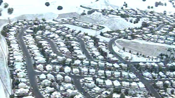
Could you imagine if this happened last year, Vancouver needed the snow for the Olympics. Looks like mega snow this year!
Yeah thats 48+ inches of snow in Vancouver .
0 likes
- brunota2003
- S2K Supporter
- Posts: 9476
- Age: 33
- Joined: Sat Jul 30, 2005 9:56 pm
- Location: Stanton, KY...formerly Havelock, NC
- Contact:
-
- Tropical Depression
- Posts: 50
- Joined: Fri Oct 30, 2009 11:07 am
- Location: Central Ohio via San Fran via Northern FL
Re: Potential Significant NorthWest coast snowstorm around 19th-
Well, this will suck (and be somewhat ironic) to be near the Great Lakes region at the time of this snow event.
I've seen pictures of snow in the 2000s of various neighborhoods in San Francisco getting trace amounts of the white stuff, but not a full blown snow event.
Outlying areas do get snow somewhat regularly though, but not at low elevations - this was a pic I posted on this forum back in 2009 of Clayton, at the foot of Mt. Diablo, which has only 400 ft of elevation
0 likes
-
- Tropical Depression
- Posts: 50
- Joined: Fri Oct 30, 2009 11:07 am
- Location: Central Ohio via San Fran via Northern FL
Re:
Metalicwx220 wrote:Do you live in an area that rarely sees snow in California? I like the pic above.
Yes. I live pretty much close to sea level - only mention I've heard about snow falling in my immediate area was an event that dropped 4 inches in the town south of me in January of 1913.
Generally speaking, the closest snowfall to me is either on one of the peaks (both Mt. Tamalpais and Mt. Diablo are roughly the same distance to me) or just north of Calistoga (in the extreme northeast SF Bay Area
0 likes
Re: Re:
fogbreath wrote:Metalicwx220 wrote:Do you live in an area that rarely sees snow in California? I like the pic above.
Yes. I live pretty much close to sea level - only mention I've heard about snow falling in my immediate area was an event that dropped 4 inches in the town south of me in January of 1913.
Generally speaking, the closest snowfall to me is either on one of the peaks (both Mt. Tamalpais and Mt. Diablo are roughly the same distance to me) or just north of Calistoga (in the extreme northeast SF Bay Area
Ohhhh... so this will be one of those rare events. La nina is taking control now so that why it will be cold and stormy in the northwest. Willl be iinteresting if any of this does pan out.
Last edited by Metalicwx220 on Thu Feb 10, 2011 9:05 pm, edited 1 time in total.
0 likes
SPECIAL WEATHER STATEMENT
in effect until Friday, Feb 11, 4:00 AM...RETURN TO COLDER AND UNSETTLED WEATHER LATE THIS WEEKEND AND NEXT WEEK...
A LARGE UPPER LEVEL TROUGH OVER THE GULF OF ALASKA WILL GRADUALLY MOVE TOWARD THE WEST COAST OVER THE NEXT COUPLE OF DAYS AND THEN INTO THE PACIFIC NORTHWEST NEXT WEEK. THIS WILL USHER A MUCH COOLER...WINDIER AND WETTER PATTERN INTO ALL OF THE PACIFIC NORTHWEST BY EARLY NEXT WEEK. THE FIRST COLD FRONT WILL BRING RAIN MAINLY TO THE CENTRAL OREGON COAST AND MOUNTAINS SATURDAY NIGHT AND EARLY SUNDAY.
A MUCH STRONGER COLD FRONT WILL BRING RAIN AND HIGHER MOUNTAIN SNOW TO ALL OF SOUTHWEST OREGON AND NORTHERN CALIFORNIA LATER MONDAY THROUGH TUESDAY. IN ADDITION...A PERIOD OF VERY WINDY WEATHER IS POSSIBLE AS THE FRONT COMES ASHORE LATE MONDAY. THIS WILL BE FOLLOWED BY YET ANOTHER COLD FRONT MID WEEK WITH MUCH LOWER SNOW LEVELS. IT IS TOO EARLY TO GIVE SPECIFICS BUT CONFIDENCE IS INCREASING IN A PERIOD OF HEAVY MOUNTAIN SNOW DURING THE MIDDLE OF NEXT WEEK WITH SNOW LOWERING TO PASS LEVELS AND POSSIBLY MIXING DOWN INTO THE VALLEYS AS WELL. STAY TUNED FOR FURTHER UPDATES TO THIS POTENTIALLY SIGNIFICANT SERIES OF STORMS NEXT WEEK. Medford, Oregon NWS........................By the way I love west coast storms.
0 likes
Potential Significant Series of snowstorms to hit the West C
First Of a series of storms to hit the Northwest with Snow, wind, and rain to hit Seattle and portland in 96hours.
0 likes
Who is online
Users browsing this forum: No registered users and 83 guests