Texas Winter 2011-2012...

Winter Weather Discussion

Moderator: S2k Moderators

Forum rules

The posts in this forum are NOT official forecast and should not be used as such. They are just the opinion of the poster and may or may not be backed by sound meteorological data. They are NOT endorsed by any professional institution or STORM2K.

Help Support Storm2K
Message
Author
Ntxw
Storm2k Moderator
Storm2k Moderator
Posts: 21490
Joined: Wed Oct 21, 2009 6:34 pm
Location: DFW, Texas

#3181 Postby Ntxw » Wed Feb 22, 2012 6:14 pm

Third big system (next tues-weds ish) is the only one that looks like it has a SLIM chance of drawing colder air far enough south. Of course that is 7 days away...and even then it doesn't look conducive south of I-40 on the models, unless you're talking about rain :P. Lets hope it trends colder! I'm tired of this May in February thing today and tomorrow, yuck!

Prospects for an el nino winter next season (maybe even by summer) looks good! Just what we Texans need :cheesy: :rain:
0 likes   
The above post and any post by Ntxw is NOT an official forecast and should not be used as such. It is just the opinion of the poster and may or may not be backed by sound meteorological data. It is NOT endorsed by any professional institution including Storm2k. For official information, please refer to NWS products.

  Help support Storm2K!
Help Support Storm2K

User avatar
Texas Snowman
Storm2k Moderator
Storm2k Moderator
Posts: 6011
Joined: Fri Jan 25, 2008 11:29 am
Location: Denison, Texas

Re:

#3182 Postby Texas Snowman » Wed Feb 22, 2012 6:22 pm

Ntxw wrote:Third big system (next tues-weds ish) is the only one that looks like it has a SLIM chance of drawing colder air far enough south. Of course that is 7 days away...and even then it doesn't look conducive south of I-40 on the models, unless you're talking about rain :P. Lets hope it trends colder! I'm tired of this May in February thing today and tomorrow, yuck!

Prospects for an el nino winter next season (maybe even by summer) looks good! Just what we Texans need :cheesy: :rain:


Ntxw - your thoughts on what dying La Nina, building El Nino mean for severe weather season here in North Texas? I've read a couple of conflicting ideas thus far, curious to see what you and Portastorm think.

Also, effects on Texas hurricane season?
0 likes   
The above post and any post by Texas Snowman is NOT an official forecast and should not be used as such. It is just the opinion of the poster and may or may not be backed by sound meteorological data. It is NOT endorsed by any professional institution including storm2k.org. For official information, please refer to NWS products.

Ntxw
Storm2k Moderator
Storm2k Moderator
Posts: 21490
Joined: Wed Oct 21, 2009 6:34 pm
Location: DFW, Texas

Re: Re:

#3183 Postby Ntxw » Wed Feb 22, 2012 6:31 pm

Texas Snowman wrote:Ntxw - your thoughts on what dying La Nina, building El Nino mean for severe weather season here in North Texas? I've read a couple of conflicting ideas thus far, curious to see what you and Portastorm think.

Also, effects on Texas hurricane season?


My skills on the two are basically zilch. La Nina is fading at a pretty steady rate since the last update, which will promote more storminess in the spring. The gulf is warm since we've had such a warm winter which usually spells an active spring, that's usually the best indicator that I've noticed past seasons. I have a hunch we won't see the tornado outbreaks like last year, but more derecho style storms. As for hurricane season my gut says we won't see as many cape verde type system as the past few especially if El Nino develops. Which could mean home brewed weaker systems might be more likely (again back to the warm gulf idea). I don't know if these correlate, but without a southeast ridge (la nina feature) heights would be lower in the gulf region which is better to induce storms I believe for Texas.
Last edited by Ntxw on Wed Feb 22, 2012 6:39 pm, edited 1 time in total.
0 likes   
The above post and any post by Ntxw is NOT an official forecast and should not be used as such. It is just the opinion of the poster and may or may not be backed by sound meteorological data. It is NOT endorsed by any professional institution including Storm2k. For official information, please refer to NWS products.


  Help support Storm2K!

Help Support Storm2K


User avatar
gboudx
S2K Supporter
S2K Supporter
Posts: 4047
Joined: Thu Sep 04, 2003 1:39 pm
Location: Rockwall, Tx but from Harvey, La

#3184 Postby gboudx » Wed Feb 22, 2012 6:36 pm

El Nino typically suppresses Atlantic tropical activity due to persistent westerly shear.
0 likes   

User avatar
Texas Snowman
Storm2k Moderator
Storm2k Moderator
Posts: 6011
Joined: Fri Jan 25, 2008 11:29 am
Location: Denison, Texas

#3185 Postby Texas Snowman » Wed Feb 22, 2012 6:41 pm

True on the El Nino typically reducing Atlantic storms. But I'm with Ntxw on more active close to home Gulf storms. And I would anticipate an active early season too, again because of the Gulf warmth.

My basic idea is that there is a price to be paid somewhere, somehow for the lack of winter in this part of the world. It may be one of those seasons where we have few numbers of storms, but one or two make it highly memorable.

Andrew in 1992 comes to mind. Season wasn't bad but no one who went through that storm will ever forget it.
0 likes   
The above post and any post by Texas Snowman is NOT an official forecast and should not be used as such. It is just the opinion of the poster and may or may not be backed by sound meteorological data. It is NOT endorsed by any professional institution including storm2k.org. For official information, please refer to NWS products.

User avatar
Texas Snowman
Storm2k Moderator
Storm2k Moderator
Posts: 6011
Joined: Fri Jan 25, 2008 11:29 am
Location: Denison, Texas

#3186 Postby Texas Snowman » Wed Feb 22, 2012 6:46 pm

Just got on Twitter, found Henry M mentioning dying La Nina. Here's an excerpt from his blog post:

http://www.accuweather.com/en/weather-b ... outh/61907

Discussion

"The La Nina continues to weaken, and as you can see in the video, the ocean temps are coming up which means we will probably be neutral or even go into an El Nino by late spring. The implications of the La Nina weakening and going away are major for the rest of the year. I really thought that the pattern would have changed by now and that we would see a negative NAO and at least one big storm, but I guess that is not going happen. I got the La Nina weakening right but the pattern changing wrong.

Here's my concern for the rest of the year. I don't believe the year will feature extreme events. The severe weather system will be normal or perhaps below normal, and the hurricane season will probably be below normal in regards to the number of storms. However with that said, perception is everything when it comes to the weather. It will only take one tornado to wipe out a town for the perception to be that the season was active again. It will only take one hurricane to hit the U.S. coast for the perception to be the hurricane season was active. So while I think the year as a whole is not going to be very extreme as we had seen last year, the perception depending on what happens might be different."
0 likes   
The above post and any post by Texas Snowman is NOT an official forecast and should not be used as such. It is just the opinion of the poster and may or may not be backed by sound meteorological data. It is NOT endorsed by any professional institution including storm2k.org. For official information, please refer to NWS products.

Ntxw
Storm2k Moderator
Storm2k Moderator
Posts: 21490
Joined: Wed Oct 21, 2009 6:34 pm
Location: DFW, Texas

Re:

#3187 Postby Ntxw » Wed Feb 22, 2012 6:48 pm

gboudx wrote:El Nino typically suppresses Atlantic tropical activity due to persistent westerly shear.


That westerly component also applies in the EPAC too I think. Which explains why Texas summers are cooler and wetter in Texas during El Ninos. Those systems like to recurve into Mexico :D
0 likes   
The above post and any post by Ntxw is NOT an official forecast and should not be used as such. It is just the opinion of the poster and may or may not be backed by sound meteorological data. It is NOT endorsed by any professional institution including Storm2k. For official information, please refer to NWS products.


  Help support Storm2K!

Help Support Storm2K


User avatar
Texas Snowman
Storm2k Moderator
Storm2k Moderator
Posts: 6011
Joined: Fri Jan 25, 2008 11:29 am
Location: Denison, Texas

Re: Texas Winter 2011-2012...

#3188 Postby Texas Snowman » Wed Feb 22, 2012 6:49 pm

Another interesting Henry M tweet...

@Henry_Margusity: "I always said that a big storm comes out of a weakening La Nina, so maybe the Euro may be on to something.... We shall see."
0 likes   
The above post and any post by Texas Snowman is NOT an official forecast and should not be used as such. It is just the opinion of the poster and may or may not be backed by sound meteorological data. It is NOT endorsed by any professional institution including storm2k.org. For official information, please refer to NWS products.

User avatar
Portastorm
Storm2k Moderator
Storm2k Moderator
Posts: 9787
Age: 61
Joined: Fri Jul 11, 2003 9:16 am
Location: South Austin, TX
Contact:

Re: Re:

#3189 Postby Portastorm » Wed Feb 22, 2012 6:52 pm

Texas Snowman wrote:
Ntxw wrote:Third big system (next tues-weds ish) is the only one that looks like it has a SLIM chance of drawing colder air far enough south. Of course that is 7 days away...and even then it doesn't look conducive south of I-40 on the models, unless you're talking about rain :P. Lets hope it trends colder! I'm tired of this May in February thing today and tomorrow, yuck!

Prospects for an el nino winter next season (maybe even by summer) looks good! Just what we Texans need :cheesy: :rain:


Ntxw - your thoughts on what dying La Nina, building El Nino mean for severe weather season here in North Texas? I've read a couple of conflicting ideas thus far, curious to see what you and Portastorm think.

Also, effects on Texas hurricane season?


I think a dying Nina working into a neutral summer combined with a fairly active Southern jet is going to mean a severe weather spring season for Texas which some of us haven't seen in a few years. There's still cold air to play with and as the proverbial battleground sets up, I really think we'll see some active systems in March and April. Not trying to scare anyone because my opinion means squat ... but I do think we're going to have a very active spring severe weather season in Texas.

Hurricane season? Well, the long-range Euro and CFS show higher than normal pressures in a lot of the Atlantic basin. I think that will put a clamp somewhat on development of the longer-tracking systems. I agree with you guys that we may see much more of the "home grown" stuff in the Gulf and less of the longer-tracking storms which form east of the Caribbean or even out in the middle Atlantic. If El Nino ramps up quicker than expected, that should help put a lid on a lot of development as has been said about the persistent westerly shear.

The above post is NOT an official forecast and should not be used as such. It is just the opinion of the poster and may or may not be backed by sound meteorological data. It is NOT endorsed by any professional institution including storm2k.org. For Official Information please refer to the NHC and NWS products.
0 likes   
Any forecasts under my name are to be taken with a grain of salt. Get your best forecasts from the National Weather Service and National Hurricane Center.

I'm a certified Advanced SKYWARN-trained spotter and am active on Twitter at @TravisCOSW, a social media partner of the NWS Austin-San Antonio office.

User avatar
Texas Snowman
Storm2k Moderator
Storm2k Moderator
Posts: 6011
Joined: Fri Jan 25, 2008 11:29 am
Location: Denison, Texas

Re: Re:

#3190 Postby Texas Snowman » Wed Feb 22, 2012 6:57 pm

Portastorm wrote:I think a dying Nina working into a neutral summer combined with a fairly active Southern jet is going to mean a severe weather spring season for Texas which some of us haven't seen in a few years. There's still cold air to play with and as the proverbial battleground sets up, I really think we'll see some active systems in March and April. Not trying to scare anyone because my opinion means squat ... but I do think we're going to have a very active spring severe weather season in Texas.


Totally agree. Think the southern plains will have a very active spring storm season.

And I haven't totally tossed in the towel of something winter mischief wise before mid-March in the I-20 to I-40 area that I live in the middle of.
0 likes   
The above post and any post by Texas Snowman is NOT an official forecast and should not be used as such. It is just the opinion of the poster and may or may not be backed by sound meteorological data. It is NOT endorsed by any professional institution including storm2k.org. For official information, please refer to NWS products.

Ntxw
Storm2k Moderator
Storm2k Moderator
Posts: 21490
Joined: Wed Oct 21, 2009 6:34 pm
Location: DFW, Texas

#3191 Postby Ntxw » Wed Feb 22, 2012 7:04 pm

Hey Portastorm, I say we open a spring office of the PWC over in the USA weather section and promote cool and wet there ;). Keep that cold mongering spirit alive in the warmer times!
0 likes   
The above post and any post by Ntxw is NOT an official forecast and should not be used as such. It is just the opinion of the poster and may or may not be backed by sound meteorological data. It is NOT endorsed by any professional institution including Storm2k. For official information, please refer to NWS products.


  Help support Storm2K!

Help Support Storm2K


User avatar
Texas Snowman
Storm2k Moderator
Storm2k Moderator
Posts: 6011
Joined: Fri Jan 25, 2008 11:29 am
Location: Denison, Texas

Re:

#3192 Postby Texas Snowman » Wed Feb 22, 2012 7:14 pm

Ntxw wrote:Hey Portastorm, I say we open a spring office of the PWC over in the USA weather section and promote cool and wet there ;). Keep that cold mongering spirit alive in the warmer times!


You want cool spring rains? You GOT IT! :rain:
0 likes   
The above post and any post by Texas Snowman is NOT an official forecast and should not be used as such. It is just the opinion of the poster and may or may not be backed by sound meteorological data. It is NOT endorsed by any professional institution including storm2k.org. For official information, please refer to NWS products.

User avatar
gboudx
S2K Supporter
S2K Supporter
Posts: 4047
Joined: Thu Sep 04, 2003 1:39 pm
Location: Rockwall, Tx but from Harvey, La

Re:

#3193 Postby gboudx » Wed Feb 22, 2012 8:16 pm

Texas Snowman wrote:Andrew in 1992 comes to mind. Season wasn't bad but no one who went through that storm will ever forget it.


True Dat. I went thru it.
0 likes   

User avatar
TeamPlayersBlue
Category 5
Category 5
Posts: 3307
Joined: Tue Feb 02, 2010 1:44 am
Location: Denver/Applewood, CO

Re: Texas Winter 2011-2012...

#3194 Postby TeamPlayersBlue » Wed Feb 22, 2012 10:17 pm

Tireman4 wrote:
hriverajr wrote:.

Who knows maybe it will be a cool rainy summer? Can't be as bad as last.

You know.. I thought that too, with the summer of 2010 a little toasty, but mostly it was the low temperatures that were so high. Last year, it started in April and did not quit until October. I was thinking..."just how long will this high stay on top of us?" Well, about that long.

For those of us that want a cool summer....


IAH
77.6 1919 June
80.0 1891 July
78.8 1894 August
74.6 1974 September

Keep hoping folks...:)


Are those avg temps for the month?
0 likes   
Personal Forecast Disclaimer:
The posts in this forum are NOT official forecast and should not be used as such. They are just the opinion of the poster and may or may not be backed by sound meteorological data. They are NOT endorsed by any professional institution or storm2k.org. For official information, please refer to the NHC and NWS products.

User avatar
Rgv20
S2K Supporter
S2K Supporter
Posts: 2456
Age: 37
Joined: Wed Jan 05, 2011 5:42 pm
Location: Edinburg/McAllen Tx

#3195 Postby Rgv20 » Wed Feb 22, 2012 11:53 pm

Looks like tomorrow is going to be on the toasty side, today we had a high of 85 at my backyard and tomorrow looks like we might be flirting with the 90F mark! :sun: 
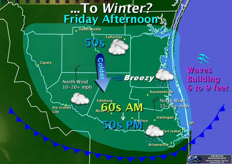
Hopefully we can get some more much needed rain come Friday and temperatures in the low 60s....thats why we get sick!

Image
Deep South Texas and the Rio Grande Valley will have one more day of very warm temperatures and elevated humidity on Thursday with afternoon highs ranging from the middle 80s across the eastern counties to near 90 across the western counties. Don't get used to the warmth just yet...dramatic changes are in store Friday as a strong cold front is expected to move through the region.-Martinez-


Image
Just when you thought winter was over...another cold front slams through the Rio Grande Valley Friday morning. A cloudy, brisk afternoon will follow with some light rain and perhaps a thunderstorm as well. Actual temperatures won't be any colder than we've seen on a few days this February...but the difference between Thursday's early May-like temperatures (85 to 90) and Friday's chill will be large...from 25 degrees to 35 degrees /colder/ at 4 PM Friday afternoon (55 to 60 in most areas). Keep the jackets and sweaters handy!
0 likes   
The following post is NOT an official forecast and should not be used as such. It is just the opinion of the poster and may or may not be backed by sound meteorological data. It is NOT endorsed by any professional institution including storm2k.org For Official Information please refer to the NHC and NWS products.

weatherdude1108
Category 5
Category 5
Posts: 4172
Joined: Tue Dec 13, 2011 1:04 pm
Location: Northwest Austin/Cedar Park, TX

Re:

#3196 Postby weatherdude1108 » Thu Feb 23, 2012 8:42 am

Ntxw wrote:Third big system (next tues-weds ish) is the only one that looks like it has a SLIM chance of drawing colder air far enough south. Of course that is 7 days away...and even then it doesn't look conducive south of I-40 on the models, unless you're talking about rain :P. Lets hope it trends colder! I'm tired of this May in February thing today and tomorrow, yuck!

Prospects for an el nino winter next season (maybe even by summer) looks good! Just what we Texans need :cheesy: :rain:


I echo that!
0 likes   

User avatar
Rgv20
S2K Supporter
S2K Supporter
Posts: 2456
Age: 37
Joined: Wed Jan 05, 2011 5:42 pm
Location: Edinburg/McAllen Tx

#3197 Postby Rgv20 » Thu Feb 23, 2012 9:19 am

From an expected High of 89 today to a forecast high of 54 on Saturday!! That is a 35 degree difference!!

Special Weather Statement

SPECIAL WEATHER STATEMENT
NATIONAL WEATHER SERVICE BROWNSVILLE TX
423 AM CST THU FEB 23 2012

TXZ248>257-231800-
ZAPATA-JIM HOGG-BROOKS-KENEDY-STARR-HIDALGO-INLAND WILLACY-
INLAND CAMERON-COASTAL WILLACY-COASTAL CAMERON-
INCLUDING THE CITIES OF...ZAPATA...HEBBRONVILLE...FALFURRIAS...
SARITA...RIO GRANDE CITY...ROMA...MCALLEN...EDINBURG...PHARR...
MISSION...WESLACO...RAYMONDVILLE...BROWNSVILLE...HARLINGEN...
PORT MANSFIELD...PORT ISABEL...SOUTH PADRE ISLAND...
LAGUNA HEIGHTS...LAGUNA VISTA
423 AM CST THU FEB 23 2012


...STRONG COLD FRONT TO BRING BIG WEATHER CHANGES FRIDAY AND SATURDAY...

SUMMER LIKE CONDITIONS TODAY TO CHANGE DRASTICALLY FRIDAY INTO
SATURDAY AS A STRONG COLD FRONT AND AN UPPER LOW PRESSURE TROUGH
MOVES THROUGH DEEP SOUTH TEXAS AND RIO GRANDE VALLEY. A
COMBINATION OF COLD TEMPERATURES...BRISK WINDS AND INCREASING
RAINFALL WILL BRING A BRIEF TOUCH OF VALLEY WINTER CONDITIONS
FRIDAY AND SATURDAY.

HIGH TEMPERATURES THIS AFTERNOON TO RISE 10 TO 15 DEGREES ABOVE
NORMAL WITH MID TO UPPER 80S EXPECTED MOST LOCATIONS. A STRONG
COLD FRONT OVER THE NORTHERN AND CENTRAL PLAINS IS GOING TO DIVE
SOUTH TONIGHT MOVING THROUGH THE RIO GRANDE VALLEY FRIDAY MORNING
AND MOVE SOUTHEAST OF SOUTH PADRE ISLAND BEFORE NOON. HIGH
TEMPERATURES ARE LIKELY TO OCCUR AROUND MIDNIGHT TONIGHT OR EARLY
MORNING WITH TEMPERATURES TO FALL STEADILY THROUGH THE DAY.
DAYTIME HIGHS FRIDAY MORNING WILL BE IN THE MID TO UPPER 50S
ACROSS THE NORTHERN COUNTIES WITH MID 60S THROUGH THE RIO GRANDE
VALLEY. BY SUNSET TEMPERATURES WILL HAVE PLUMMETED INTO THE UPPER
40S TO LOWER 50S. THE FRONT WILL BE ACCOMPANIED BY STRONG NORTH
WINDS OF 20 TO 30 MPH WITH HIGHER GUSTS. THESE BRISK WINDS WILL
PUSH WIND CHILLS INTO THE MID TO LOWER 40S. RAIN CHANCES INCREASE
WITH THE FRONT WIDESPREAD RAIN DEVELOPING LATE FRIDAY
AFTERNOON...FRIDAY NIGHT AND SATURDAY.

TEMPERATURES CONTINUE TO PLUMMET FRIDAY NIGHT INTO THE 40S AND
LOWER 50S WITH LITTLE RECOVERY SATURDAY. ALL INDICATORS POINT TO A
CLOUDY...RAINY AND BRISK DAY. NORTH WINDS OF 15 TO 25 MPH AND ON
AND OFF RAIN AND DRIZZLE WILL KEEP TEMPERATURES RATHER CHILLY.
HIGHS ONLY BETWEEN 50 AND 55 DEGREES POSSIBLY COOLER ARE EXPECTED.


MARINE CONDITIONS WILL DETERIORATE RAPIDLY WITH THE PASSAGE OF THE
COLD FRONT AND REMAIN ADVERSE THROUGH THE WEEKEND. NORTH WINDS OF
20 TO 30 KNOTS WITH SOME GUSTS TO GALE FORCE ARE EXPECTED MAINLY
ON SATURDAY. SEAS TO BUILD OVER 10 FEET. AN EXTENDED PERIOD OF SMALL
CRAFT ADVISORIES ARE LIKELY WITH A SMALL WIND OF GALE CONDITIONS
SATURDAY.

STAY TUNED TO NOAA WEATHER RADIO FOR THE LATEST FORECAST AND
STATEMENTS FROM THE NATIONAL WEATHER SERVICE. FOR ALL OF YOUR LOCAL
WEATHER NEEDS...GO TO OUR WEBSITE AT HTTP://WEATHER.GOV/RGV


$$


GB
0 likes   
The following post is NOT an official forecast and should not be used as such. It is just the opinion of the poster and may or may not be backed by sound meteorological data. It is NOT endorsed by any professional institution including storm2k.org For Official Information please refer to the NHC and NWS products.

User avatar
wxman57
Moderator-Pro Met
Moderator-Pro Met
Posts: 22480
Age: 66
Joined: Sat Jun 21, 2003 8:06 pm
Location: Houston, TX (southwest)

Re: Texas Winter 2011-2012...

#3198 Postby wxman57 » Thu Feb 23, 2012 9:26 am

What? No one here is discussing this weekend's snow along the Texas coast? That's according to the 06Z GFS, anyway.
0 likes   

User avatar
Tireman4
S2K Supporter
S2K Supporter
Posts: 5674
Age: 58
Joined: Fri Jun 30, 2006 1:08 pm
Location: Humble, Texas
Contact:

Re: Texas Winter 2011-2012...

#3199 Postby Tireman4 » Thu Feb 23, 2012 9:36 am

TeamPlayersBlue wrote:
Tireman4 wrote:
hriverajr wrote:.

Who knows maybe it will be a cool rainy summer? Can't be as bad as last.

You know.. I thought that too, with the summer of 2010 a little toasty, but mostly it was the low temperatures that were so high. Last year, it started in April and did not quit until October. I was thinking..."just how long will this high stay on top of us?" Well, about that long.

For those of us that want a cool summer....


IAH
77.6 1919 June
80.0 1891 July
78.8 1894 August
74.6 1974 September

Keep hoping folks...:)


Are those avg temps for the month?


Yes..the high and the low....
0 likes   

Ntxw
Storm2k Moderator
Storm2k Moderator
Posts: 21490
Joined: Wed Oct 21, 2009 6:34 pm
Location: DFW, Texas

Re: Texas Winter 2011-2012...

#3200 Postby Ntxw » Thu Feb 23, 2012 10:01 am

wxman57 wrote:What? No one here is discussing this weekend's snow along the Texas coast? That's according to the 06Z GFS, anyway.


Euro doesnt show anything and its almost dead on 48 hours out. Might be a smal pocket of cold aloft under the 5h low but that would only spell a slim chance of sleet or graupel near the heaviest precip around CC. But with near 90 today there I doubt it :P.

Im hoping the front moves fast so dfw could miss the 80 before front comes at 2. But areas south of I-20 wont be so lucky :(
0 likes   
The above post and any post by Ntxw is NOT an official forecast and should not be used as such. It is just the opinion of the poster and may or may not be backed by sound meteorological data. It is NOT endorsed by any professional institution including Storm2k. For official information, please refer to NWS products.


  Help support Storm2K!

Help Support Storm2K


Return to “Winter Weather”

Who is online

Users browsing this forum: No registered users and 26 guests