Oklahoma Winter Weather 2011-2012
Moderator: S2k Moderators
Forum rules
 The posts in this forum are NOT official forecast and should not be used as such. They are just the opinion of the poster and may or may not be backed by sound meteorological data. They are NOT endorsed by any professional institution or STORM2K.

The posts in this forum are NOT official forecast and should not be used as such. They are just the opinion of the poster and may or may not be backed by sound meteorological data. They are NOT endorsed by any professional institution or STORM2K.
-
TwisterFanatic

- Category 5

- Posts: 1041
- Joined: Mon Jun 28, 2010 12:43 pm
- Location: Sallisaw, Oklahoma
Yep, and the Cold doesn't go anywhere afterwards.
0 likes
Personal Forecast Disclaimer:
The posts in this forum are NOT official forecast and should not be used as such. They are just the opinion of the poster and may or may not be backed by sound meteorological data. They are NOT endorsed by any professional institution or storm2k.org. For official information, please refer to the NHC and NWS products.
The posts in this forum are NOT official forecast and should not be used as such. They are just the opinion of the poster and may or may not be backed by sound meteorological data. They are NOT endorsed by any professional institution or storm2k.org. For official information, please refer to the NHC and NWS products.
-
Extremeweatherguy

- Category 5
- Posts: 11095
- Joined: Mon Oct 10, 2005 8:13 pm
- Location: Houston, TX
Re: Oklahoma Winter Weather 2011-2012
Definitely looking interesting for this upcoming weekend. It is still a little too early to nail down the exact scenario that will take shape, but it definitely is appearing more and more likely that we will see precipitation (of some type) and more cold air arriving from the north. Big questions still remain though regarding the strength/speed of the shortwave/upper level low that will be to our west and the timing and strength of the incoming cold airmass. If things line up perfectly, then there could certainly be a significant winter storm across the region. Even if they don't line up perfectly though, it appears increasingly likely that some areas will at least see some sort of mixing (especially along and north of I-40) during the weekend. Could make for an interesting OU/OSU game this Saturday evening in Stillwater. A repeat of the 1985 ice bowl perhaps??
By the way, if the latest runs of the GFS wind up verifying, then the cold air that arrives behind the precipitation could be of significant importance as well. The 18z run is showing sub-freezing high temperatures for OKC on both Sunday and Monday with overnight lows falling into the teens. If this verifies, then any wintry-type precipitation that fell would likely be slow to melt across the region. Brrr.
By the way, if the latest runs of the GFS wind up verifying, then the cold air that arrives behind the precipitation could be of significant importance as well. The 18z run is showing sub-freezing high temperatures for OKC on both Sunday and Monday with overnight lows falling into the teens. If this verifies, then any wintry-type precipitation that fell would likely be slow to melt across the region. Brrr.
0 likes
-
TwisterFanatic
- Category 5
- Posts: 1041
- Joined: Mon Jun 28, 2010 12:43 pm
- Location: Sallisaw, Oklahoma
0z GFS went a tad further north with the storm this run, thus setting up the heaviest band of snow through the Texas Panhandle up through North-Central OK up into SE Kansas and Missouri.
Still a very cold pattern afterwards for much of the country.
Still a very cold pattern afterwards for much of the country.
0 likes
Personal Forecast Disclaimer:
The posts in this forum are NOT official forecast and should not be used as such. They are just the opinion of the poster and may or may not be backed by sound meteorological data. They are NOT endorsed by any professional institution or storm2k.org. For official information, please refer to the NHC and NWS products.
The posts in this forum are NOT official forecast and should not be used as such. They are just the opinion of the poster and may or may not be backed by sound meteorological data. They are NOT endorsed by any professional institution or storm2k.org. For official information, please refer to the NHC and NWS products.
-
jporterOCCC
- Tropical Low

- Posts: 34
- Age: 43
- Joined: Sun Jan 30, 2011 3:12 pm
- Location: SW OKC
Defiantly going to be watching the models this week, in hopes that Central Oklahoma gets a decent amount of snow. I didn't get to chase many tornadoes this year so may be I can have fun in the snow instead.
Going to be doing some maintenance on the chase mobile and get it ready for this weekend
Going to be doing some maintenance on the chase mobile and get it ready for this weekend
0 likes
-
TwisterFanatic
- Category 5
- Posts: 1041
- Joined: Mon Jun 28, 2010 12:43 pm
- Location: Sallisaw, Oklahoma
CMC still taking this storm way west again. Through the OK/TX Panhandles, up into Kansas.
0 likes
Personal Forecast Disclaimer:
The posts in this forum are NOT official forecast and should not be used as such. They are just the opinion of the poster and may or may not be backed by sound meteorological data. They are NOT endorsed by any professional institution or storm2k.org. For official information, please refer to the NHC and NWS products.
The posts in this forum are NOT official forecast and should not be used as such. They are just the opinion of the poster and may or may not be backed by sound meteorological data. They are NOT endorsed by any professional institution or storm2k.org. For official information, please refer to the NHC and NWS products.
-
Extremeweatherguy
- Category 5
- Posts: 11095
- Joined: Mon Oct 10, 2005 8:13 pm
- Location: Houston, TX
Re: Oklahoma Winter Weather 2011-2012
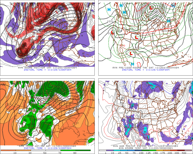
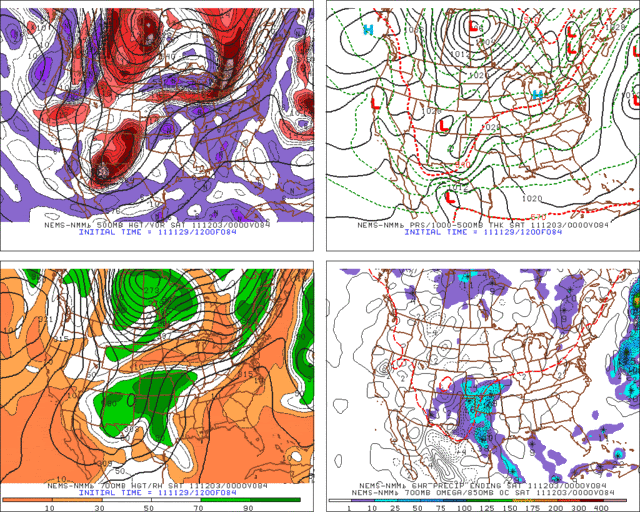
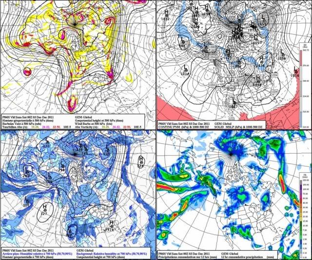
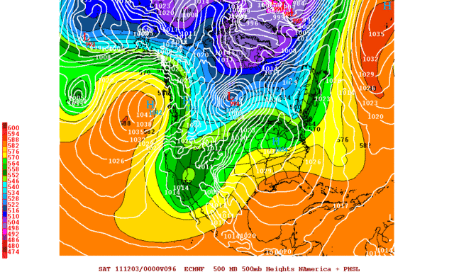
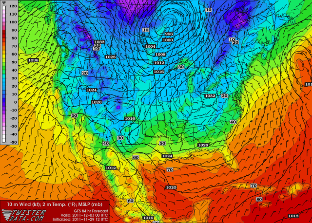
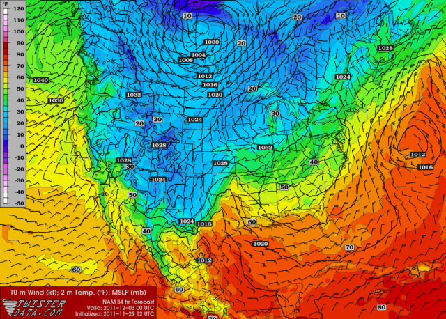
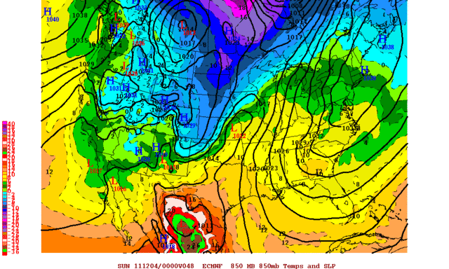
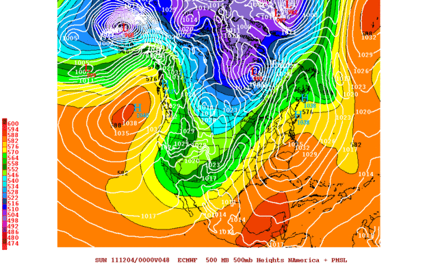
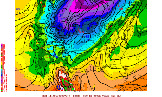
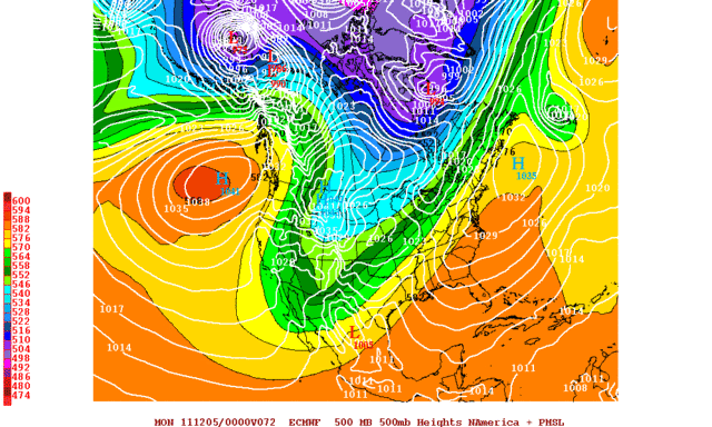
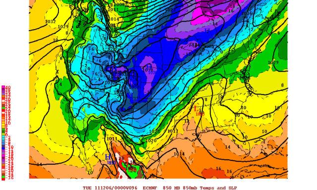
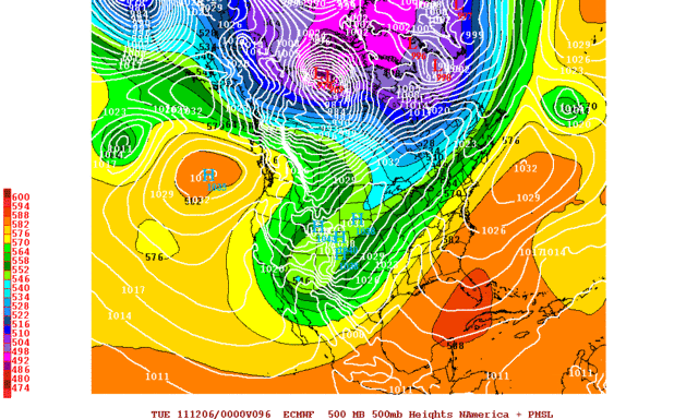
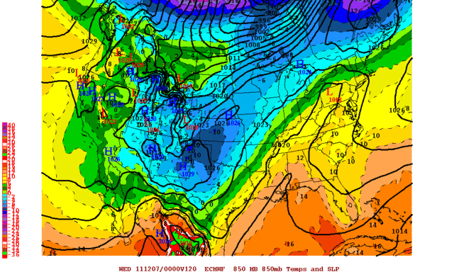
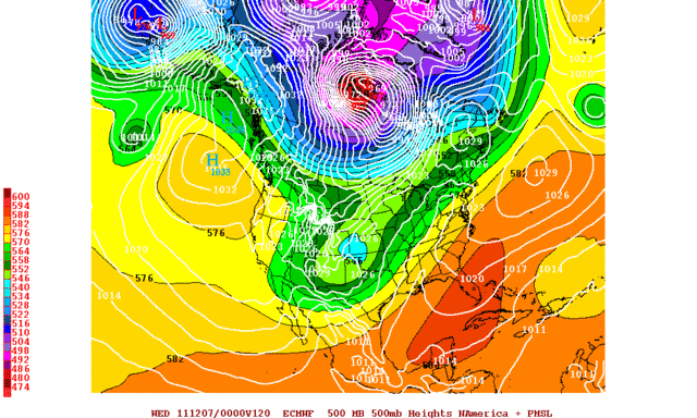
The models are having a hard time with this upcoming pattern. Check out the differences at just 84 hours out...
Note the differences with the 500mb ULL/shortwave trough:
12z GFS - http://i43.photobucket.com/albums/e371/ ... /f84-1.gif
12z NAM - http://i43.photobucket.com/albums/e371/ ... /f84-2.gif
12z CMC - http://i43.photobucket.com/albums/e371/ ... 12_084.jpg
00z ECMWF - http://i43.photobucket.com/albums/e371/ ... TNA096.gif
While similar overall, the strength and speed varies, which could have large consequences down the road. As you move beyond 84 hours, the changes become even more pronounced, with the ECMWF for instance holding the ULL/shortwave trough back in the SW USA for several days.
Also note the major surface temperature differences between the GFS and NAM for Friday evening:
12z GFS - http://i43.photobucket.com/albums/e371/ ... GROUND.png
12z NAM - http://i43.photobucket.com/albums/e371/ ... GROUND.png
That's a 10+ degree difference in parts of the state between the two models at just 3.5 days out! These kind of differences become very important when you have to start considering precipitation type, and it will be very interesting to see how this all evolves in the coming days.
0 likes
-
BlueIce
- S2K Supporter

- Posts: 194
- Age: 35
- Joined: Mon Sep 01, 2008 10:05 pm
- Location: Oklahoma City, Oklahoma
Re: Oklahoma Winter Weather 2011-2012
Extremeweatherguy wrote:The models are having a hard time with this upcoming pattern. Check out the differences at just 84 hours out...
Note the differences with the 500mb ULL/shortwave trough:
12z GFS - http://i43.photobucket.com/albums/e371/ ... /f84-1.gif
12z NAM - http://i43.photobucket.com/albums/e371/ ... /f84-2.gif
12z CMC - http://i43.photobucket.com/albums/e371/ ... 12_084.jpg
00z ECMWF - http://i43.photobucket.com/albums/e371/ ... TNA096.gif
While similar overall, the strength and speed varies, which could have large consequences down the road. As you move beyond 84 hours, the changes become even more pronounced, with the ECMWF for instance holding the ULL/shortwave trough back in the SW USA for several days.
Also note the major surface temperature differences between the GFS and NAM for Friday evening:
12z GFS - http://i43.photobucket.com/albums/e371/ ... GROUND.png
12z NAM - http://i43.photobucket.com/albums/e371/ ... GROUND.png
That's a 10+ degree difference in parts of the state between the two models at just 3.5 days out! These kind of differences become very important when you have to start considering precipitation type, and it will be very interesting to see how this all evolves in the coming days.
We definitely know that a ton of moisture is heading our way based on the precip totals. My gut feeling on this is we could be heading towards just the right scenario for an ice storm or just a big cold rain. I think that snow may be out of reach in central Oklahoma. It will be interesting to see what happens with the high temperatures between now and Friday. If the cold air pushes faster we could have a very interesting bedlam forecast.
0 likes
-
jporterOCCC
- Tropical Low
- Posts: 34
- Age: 43
- Joined: Sun Jan 30, 2011 3:12 pm
- Location: SW OKC
Re: Oklahoma Winter Weather 2011-2012
I agree BlueIce. With the current models I am leaning towards more rain than anything. I am still hopeful for snow more than ice, if we get any freezing precip.
0 likes
-
BlueIce
- S2K Supporter
- Posts: 194
- Age: 35
- Joined: Mon Sep 01, 2008 10:05 pm
- Location: Oklahoma City, Oklahoma
Re: Oklahoma Winter Weather 2011-2012
jporterOCCC wrote:I agree BlueIce. With the current models I am leaning towards more rain than anything. I am still hopeful for snow more than ice, if we get any freezing precip.
I'm going to believe this one isn't going to materialize but the NAM is showing slightly colder air still then the GFS.
Also, looking at the comparison between the 500mb Vorticity map the GFS has the system lagging to the SW while the NAM is moving it over New Mexico at the same times.
GFS at 72 hours

NAM at 72 Hours

0 likes
-
Extremeweatherguy
- Category 5
- Posts: 11095
- Joined: Mon Oct 10, 2005 8:13 pm
- Location: Houston, TX
Yeah, late this week through the weekend is definitely looking like a mostly rain event across central Oklahoma. A few places could see a little light icing if the temperature can manage to get down near the freezing mark at the beginning of the event, but most the precipitation Friday night through Saturday will probably be just a cold rain, with perhaps a brief changeover to snow for far north and west zones.
It is worth noting though that the recent trend in the models (GFS, ECMWF, CMC, and even now the NAM) has been to hold back the main energy associated with the shortwave trough/ULL across the desert southwest region into early next week. If this is the case, then it is certainly not out of the question that we may get another shot at some wintry-type precipitation sometime next week.
It is worth noting though that the recent trend in the models (GFS, ECMWF, CMC, and even now the NAM) has been to hold back the main energy associated with the shortwave trough/ULL across the desert southwest region into early next week. If this is the case, then it is certainly not out of the question that we may get another shot at some wintry-type precipitation sometime next week.
0 likes
-
BlueIce
- S2K Supporter
- Posts: 194
- Age: 35
- Joined: Mon Sep 01, 2008 10:05 pm
- Location: Oklahoma City, Oklahoma
Re:
Extremeweatherguy wrote:Yeah, late this week through the weekend is definitely looking like a mostly rain event across central Oklahoma. A few places could see a little light icing if the temperature can manage to get down near the freezing mark at the beginning of the event, but most the precipitation Friday night through Saturday will probably be just a cold rain, with perhaps a brief changeover to snow for far north and west zones.
It is worth noting though that the recent trend in the models (GFS, ECMWF, CMC, and even now the NAM) has been to hold back the main energy associated with the shortwave trough/ULL across the desert southwest region into early next week. If this is the case, then it is certainly not out of the question that we may get another shot at some wintry-type precipitation sometime next week.
The lag you have noted is consistent throughout the latest model runs the GFS is still holding this system back and maybe even showing some intensification in the SW. It also looks like some of the precipitation totals are trending downward for central Oklahoma as well. The joy of watching winter storm systems.
0 likes
-
TwisterFanatic
- Category 5
- Posts: 1041
- Joined: Mon Jun 28, 2010 12:43 pm
- Location: Sallisaw, Oklahoma
144 hours of the EURO is interesting. Swings the main energy through on Wednesday or so. Certainly cold enough for winter precip.
0 likes
Personal Forecast Disclaimer:
The posts in this forum are NOT official forecast and should not be used as such. They are just the opinion of the poster and may or may not be backed by sound meteorological data. They are NOT endorsed by any professional institution or storm2k.org. For official information, please refer to the NHC and NWS products.
The posts in this forum are NOT official forecast and should not be used as such. They are just the opinion of the poster and may or may not be backed by sound meteorological data. They are NOT endorsed by any professional institution or storm2k.org. For official information, please refer to the NHC and NWS products.
-
Extremeweatherguy
- Category 5
- Posts: 11095
- Joined: Mon Oct 10, 2005 8:13 pm
- Location: Houston, TX
Things continue to look more and more interesting for early next week.
The NAM is showing the possibility of flurries or snow showers across parts of the region Sunday into Monday (where the run ends), the GFS has been hinting at at least some flurries on Monday, with possible light snow accumulations in south Oklahoma and Texas, and the latest CMC shows a prolonged winter event across the region with several waves of wintry precipitation working up from Texas through Oklahoma late Sunday through early Wednesday ( http://www.meteo.psu.edu/~gadomski/CMC_0zA/cmcloop.html )
The 00z ECMWF, which is running now, also looks quite positive in terms of winter weather potential:
48HR (Sat. Evening)
http://i43.photobucket.com/albums/e371/ ... S048-1.gif
http://i43.photobucket.com/albums/e371/ ... TNA048.gif
72HR (Sun. Evening)
http://i43.photobucket.com/albums/e371/ ... S072-1.gif
http://i43.photobucket.com/albums/e371/ ... TNA072.gif
96HR (Mon. Evening)
http://i43.photobucket.com/albums/e371/ ... S096-1.gif
http://i43.photobucket.com/albums/e371/ ... A096-1.gif
120HR (Tues. Evening)
http://i43.photobucket.com/albums/e371/ ... S120-1.gif
http://i43.photobucket.com/albums/e371/ ... TNA120.gif
All in all, it definitely appears as though the Sunday afternoon through Wednesday morning timeframe (centered on Monday and Tuesday), could potentially be an interesting one across the area. While I am not sold on a decent winter event right now, the trends are certainly hinting at that being a real possibility. At the very least, we might get at least a few flurries. Going to be fun to watch..
0 likes
-
TwisterFanatic
- Category 5
- Posts: 1041
- Joined: Mon Jun 28, 2010 12:43 pm
- Location: Sallisaw, Oklahoma
Yep, the models are starting to get interesting. Last night the models diverged, but tonight they all agree on at least some flurries flying through the air. The CMC is very interesting to say the least.
0 likes
Personal Forecast Disclaimer:
The posts in this forum are NOT official forecast and should not be used as such. They are just the opinion of the poster and may or may not be backed by sound meteorological data. They are NOT endorsed by any professional institution or storm2k.org. For official information, please refer to the NHC and NWS products.
The posts in this forum are NOT official forecast and should not be used as such. They are just the opinion of the poster and may or may not be backed by sound meteorological data. They are NOT endorsed by any professional institution or storm2k.org. For official information, please refer to the NHC and NWS products.

Hunker down Oklahoma it's a comin  . GFS is going all out -EPO, +PNA not too long so the cold will be aiming right for the sooner state in the coming weeks!
0 likes
The above post and any post by Ntxw is NOT an official forecast and should not be used as such. It is just the opinion of the poster and may or may not be backed by sound meteorological data. It is NOT endorsed by any professional institution including Storm2k. For official information, please refer to NWS products.
Help support Storm2K!
-
TwisterFanatic
- Category 5
- Posts: 1041
- Joined: Mon Jun 28, 2010 12:43 pm
- Location: Sallisaw, Oklahoma
Will be interesting to see if the NWS bites.
0 likes
Personal Forecast Disclaimer:
The posts in this forum are NOT official forecast and should not be used as such. They are just the opinion of the poster and may or may not be backed by sound meteorological data. They are NOT endorsed by any professional institution or storm2k.org. For official information, please refer to the NHC and NWS products.
The posts in this forum are NOT official forecast and should not be used as such. They are just the opinion of the poster and may or may not be backed by sound meteorological data. They are NOT endorsed by any professional institution or storm2k.org. For official information, please refer to the NHC and NWS products.
-
TwisterFanatic
- Category 5
- Posts: 1041
- Joined: Mon Jun 28, 2010 12:43 pm
- Location: Sallisaw, Oklahoma
NAM is on board now, 6 inches of Snow in Central OK at end of run and still falling.
0 likes
Personal Forecast Disclaimer:
The posts in this forum are NOT official forecast and should not be used as such. They are just the opinion of the poster and may or may not be backed by sound meteorological data. They are NOT endorsed by any professional institution or storm2k.org. For official information, please refer to the NHC and NWS products.
The posts in this forum are NOT official forecast and should not be used as such. They are just the opinion of the poster and may or may not be backed by sound meteorological data. They are NOT endorsed by any professional institution or storm2k.org. For official information, please refer to the NHC and NWS products.
-
gypsywitch
- Tropical Wave

- Posts: 2
- Joined: Tue Oct 25, 2011 9:42 am
- Location: Blanchard/ Oklahoma City
Re: Oklahoma Winter Weather 2011-2012
Hi guys, I am trying to follow this a little bit, because I found this forum, and I love Oklahoma weather. Some of the technical or slang terms are not familiar to me, however. TwisterFanatic? Can you please explain "NAM"? And I though the forecast was saying that it is going to be too warm for snow or ice in central OK. (I live in the blanchard area, and work in okc, so I like to know what i have to drive in!)
0 likes
GypsyWitch
-
TwisterFanatic
- Category 5
- Posts: 1041
- Joined: Mon Jun 28, 2010 12:43 pm
- Location: Sallisaw, Oklahoma
18z NAM moved the heaviest precip East by about 40 miles or so, so now instead of Central OK now East/Central OK.
GFS also in line with that, but not as aggressive with Snowfall totals.
GFS also in line with that, but not as aggressive with Snowfall totals.
0 likes
Personal Forecast Disclaimer:
The posts in this forum are NOT official forecast and should not be used as such. They are just the opinion of the poster and may or may not be backed by sound meteorological data. They are NOT endorsed by any professional institution or storm2k.org. For official information, please refer to the NHC and NWS products.
The posts in this forum are NOT official forecast and should not be used as such. They are just the opinion of the poster and may or may not be backed by sound meteorological data. They are NOT endorsed by any professional institution or storm2k.org. For official information, please refer to the NHC and NWS products.
Who is online
Users browsing this forum: No registered users and 152 guests