Well a local meteorologist just called Major Winter Storm forecasting a ton of snow for the metro.
So the big question, will the 18z run verify?
Oklahoma Winter Weather 2011-2012
Moderator: S2k Moderators
Forum rules
 The posts in this forum are NOT official forecast and should not be used as such. They are just the opinion of the poster and may or may not be backed by sound meteorological data. They are NOT endorsed by any professional institution or STORM2K.

The posts in this forum are NOT official forecast and should not be used as such. They are just the opinion of the poster and may or may not be backed by sound meteorological data. They are NOT endorsed by any professional institution or STORM2K.

Re: Oklahoma Winter Weather 2011-2012
I saw that as well, I was wondering about Sw Ok down by Altus!
0 likes
-
South Texas Storms

- Professional-Met

- Posts: 4002
- Joined: Thu Jun 24, 2010 12:28 am
- Location: Houston, TX
Re: Oklahoma Winter Weather 2011-2012
gypsywitch wrote:Hi guys, I am trying to follow this a little bit, because I found this forum, and I love Oklahoma weather. Some of the technical or slang terms are not familiar to me, however. TwisterFanatic? Can you please explain "NAM"? And I though the forecast was saying that it is going to be too warm for snow or ice in central OK. (I live in the blanchard area, and work in okc, so I like to know what i have to drive in!)
Hello gypsywitch and welcome to Storm2K! The NAM stands for North American Mesoscale and it is a relatively high resolution weather computer model that we look at to determine our weather forecasts. The GFS (Global Forecast System) and Euro (European Model) are also weather computer models that we look at for our weather forecasts. The latest trends in these models is for your area to get at least some snow around Monday. The National Weather Service (NWS) in Norman, OK is giving you a 50% chance on snow on Monday. Snowfall totals are too hard to pinpoint this far in advance (we probably will have a good idea by Saturday night or Sunday), but the NAM model is showing several inches for OKC. Stay tuned!
0 likes
-
TwisterFanatic

- Category 5

- Posts: 1041
- Joined: Mon Jun 28, 2010 12:43 pm
- Location: Sallisaw, Oklahoma
NAM, GFS, and the EURO still on board. Haven't looked at the CMC yet.
0 likes
Personal Forecast Disclaimer:
The posts in this forum are NOT official forecast and should not be used as such. They are just the opinion of the poster and may or may not be backed by sound meteorological data. They are NOT endorsed by any professional institution or storm2k.org. For official information, please refer to the NHC and NWS products.
The posts in this forum are NOT official forecast and should not be used as such. They are just the opinion of the poster and may or may not be backed by sound meteorological data. They are NOT endorsed by any professional institution or storm2k.org. For official information, please refer to the NHC and NWS products.
-
Rgv20

- S2K Supporter

- Posts: 2456
- Age: 37
- Joined: Wed Jan 05, 2011 5:42 pm
- Location: Edinburg/McAllen Tx
0zNAM Snow totals thru 6pm Monday.
0 likes
The following post is NOT an official forecast and should not be used as such. It is just the opinion of the poster and may or may not be backed by sound meteorological data. It is NOT endorsed by any professional institution including storm2k.org For Official Information please refer to the NHC and NWS products.
-
BlueIce
- S2K Supporter
- Posts: 194
- Age: 35
- Joined: Mon Sep 01, 2008 10:05 pm
- Location: Oklahoma City, Oklahoma
Re:
Rgv20 wrote::uarrow: 0zNAM goes crazy with Snow totals of 10+ inches for a large part of eastern Oklahoma thru Monday 6pm!! Would be more inclined to believe the more believable 12zECMWF which shows 2 to 6 inches for much of the same area. As things look now IMO the Tulsa area looks to be the big winner in regards to snow totals...just an educated guess.
0zNAM Snow totals thru 6pm Monday.
Seems like the next NAM run didn't really give us anything to work with. The 06z run of it and the GFS has pulled the snow totals way down. I still am not 100% sold on this happening.
0 likes
-
Rgv20
- S2K Supporter
- Posts: 2456
- Age: 37
- Joined: Wed Jan 05, 2011 5:42 pm
- Location: Edinburg/McAllen Tx
0 likes
The following post is NOT an official forecast and should not be used as such. It is just the opinion of the poster and may or may not be backed by sound meteorological data. It is NOT endorsed by any professional institution including storm2k.org For Official Information please refer to the NHC and NWS products.
-
BlueIce
- S2K Supporter
- Posts: 194
- Age: 35
- Joined: Mon Sep 01, 2008 10:05 pm
- Location: Oklahoma City, Oklahoma
Re:
Rgv20 wrote::uarrow: 12zECMWF really backed of on Snow totals thru 6pm Monday...Mostly showing a trace to half an inch of snow for the eastern half of the state. However the Euro does show a bulls eye of 3-6 inches in Fayetteville in extreme NE Arkansas.
The 18z NAM is running right now. I am willing to bet that it will continue to show nothing interesting. We needed the moisture any way it comes though.
0 likes
-
Extremeweatherguy

- Category 5
- Posts: 11095
- Joined: Mon Oct 10, 2005 8:13 pm
- Location: Houston, TX
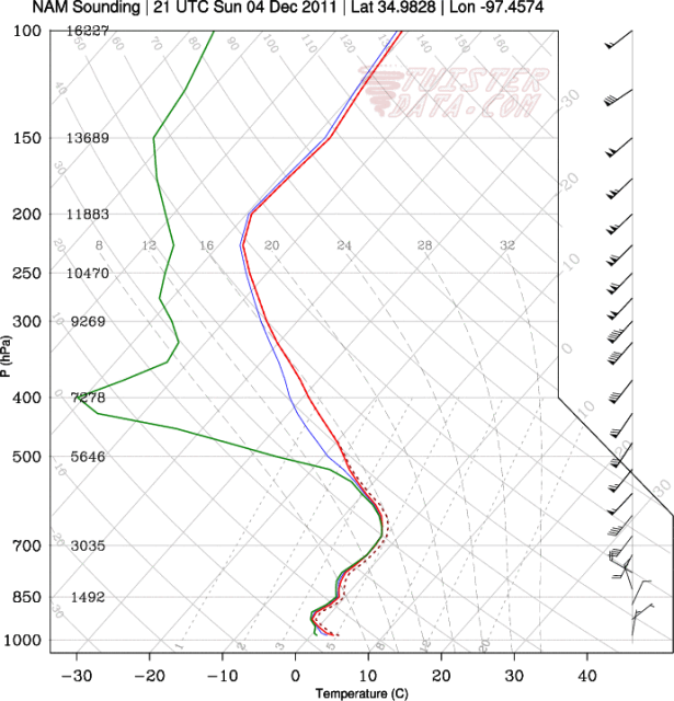
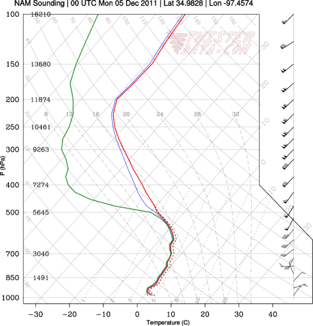
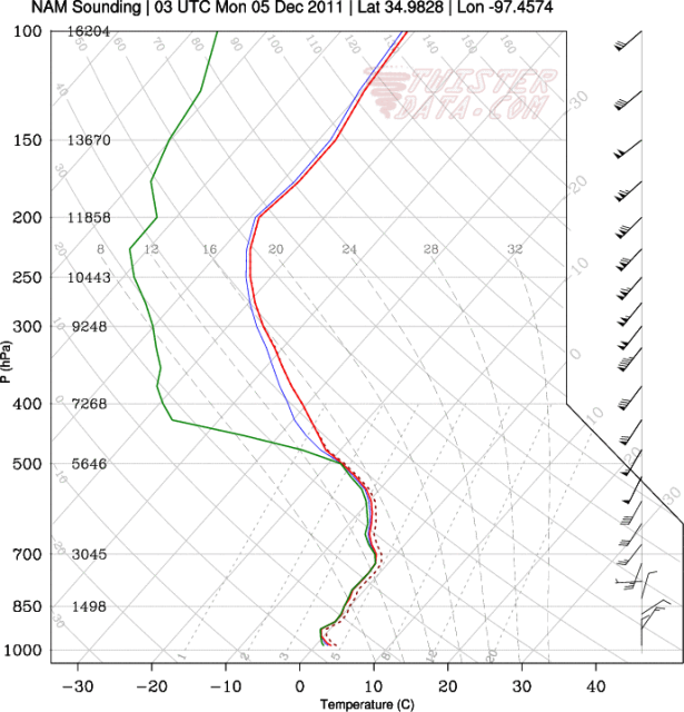
It is looking like Sunday afternoon through Monday afternoon will be the time to watch in the near term. It doesn't look like we're in store for the big snow storm the models were trying to show yesterday, but I certainly wouldn't rule out their being a swath of light accumulations somewhere in this vicinity.
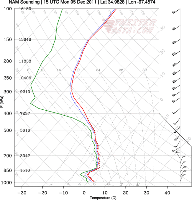
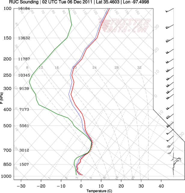
Here are some soundings from the 18z NAM for just south of OKC, near Purcell, OK during the Sunday into Monday timeframe..
(sounding location: http://maps.google.com/maps?hl=en&clien ... a=N&tab=wl)
3pm SUN - http://i43.photobucket.com/albums/e371/ ... 75000W.png
6pm SUN - http://i43.photobucket.com/albums/e371/ ... 75000W.png
9pm SUN - http://i43.photobucket.com/albums/e371/ ... 75000W.png
12am MON - http://i43.photobucket.com/albums/e371/ ... 75000W.png
9am MON - http://i43.photobucket.com/albums/e371/ ... 75000W.png
Using the top down method, some of these soundings look very favorable for snow production in the upper levels, with saturation in the dendritic growth zone of the cloud layer (-12C to -18C). The column then stays below 0C until just above the surface, where it shoots back up to just above freezing.
If these soundings played out exactly, then it would be very borderline, but I wouldn't be surprised to see periods of snow mixed with rain. If the surface is slightly colder though, then it would be all snow; perhaps even coming down decently at times.
It is definitely going to be interesting to watch how this all evolves..
(UPDATE: Trend since the 18z run has been more negative. Less and less moisture shown to be around. Most of the precipitation stays to our south and east.)
0 likes
-
Extremeweatherguy
- Category 5
- Posts: 11095
- Joined: Mon Oct 10, 2005 8:13 pm
- Location: Houston, TX
Well it looks like this storm has turned into pretty much a dud. We could still see a little bit of rain mixing with or turning to light snow tonight if any of the showers can work their way far enough north and west, but overall it is looking like the chance for appreciable accumulations has declined significantly.
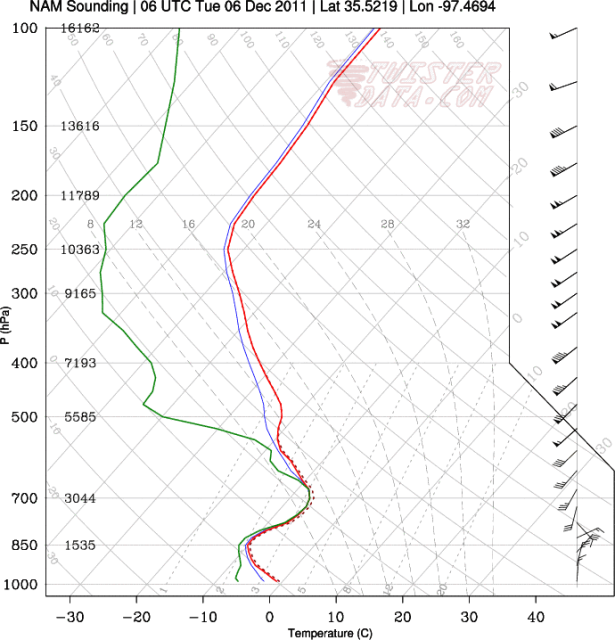
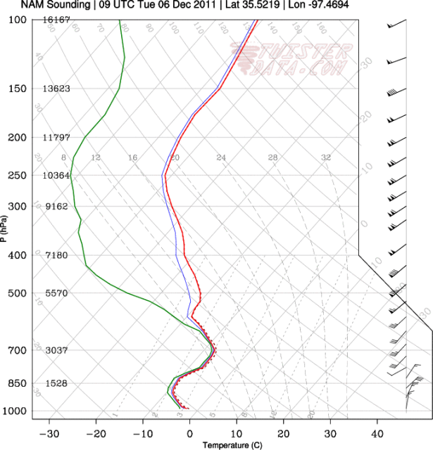
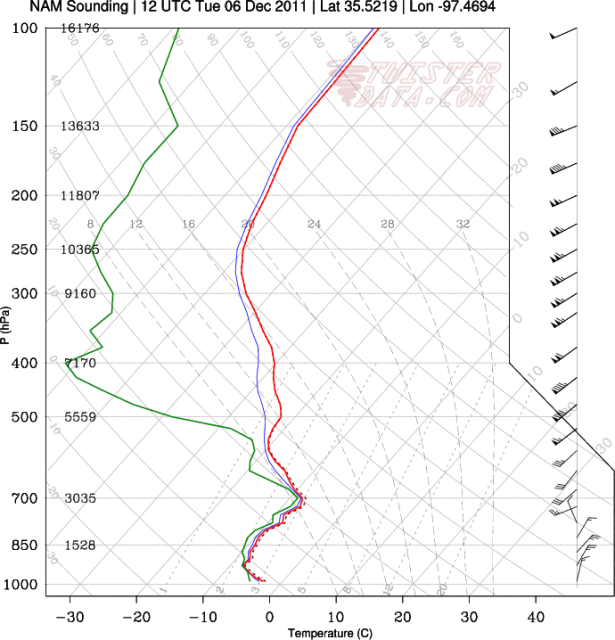
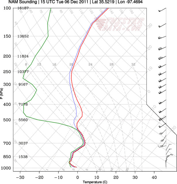
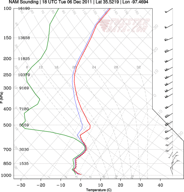
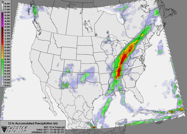
There is some hint showing up in the recent models that Monday night into Tuesday might provide a better shot for light to moderate snow and possible minor accumulations though. The trend initially kept this precipitation north and west, but a couple of the latest runs have trended more widespread to the south and east. Based on the recent performance of the models, I probably won't buy into this scenario just yet, but it is definitely something to keep an eye on. Check out the graphics I pulled from the 18z NAM below:
Skew-Ts near OKC:
12AM TUE - http://i43.photobucket.com/albums/e371/ ... 75000W.png
3AM TUE - http://i43.photobucket.com/albums/e371/ ... 75000W.png
6AM TUE - http://i43.photobucket.com/albums/e371/ ... 75000W.png
9AM TUE - http://i43.photobucket.com/albums/e371/ ... 75000W.png
12PM TUE - http://i43.photobucket.com/albums/e371/ ... 75000W.png
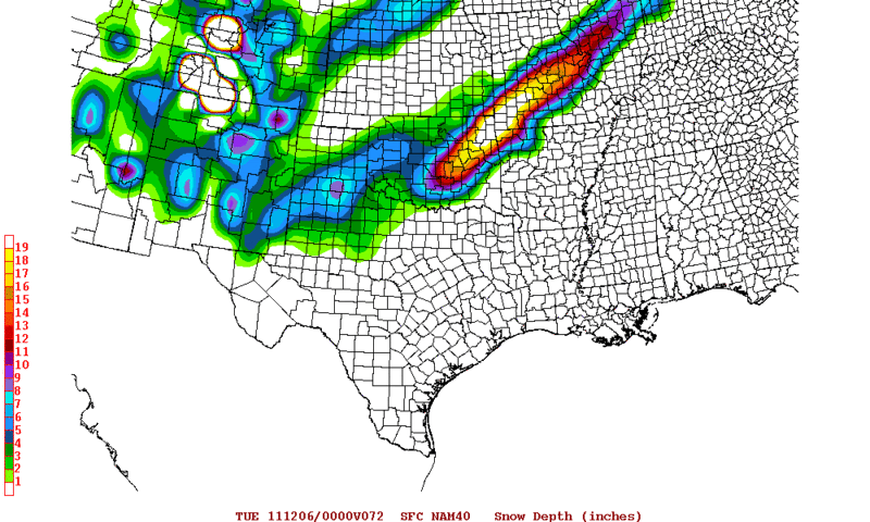
Snow accumulation map at 12PM TUE - http://i43.photobucket.com/albums/e371/ ... URFACE.png
(A widespread dusting to near 1" across most of the state. 1-3" in northwest counties and panhandle)
*The 18z GFS does not really agree with the NAM, and continues a drier look. It shows clouds Monday night into Tuesday, but no real precipitation reaching the surface.
*The 00z NAM has also come in a little less bullish.
There is some hint showing up in the recent models that Monday night into Tuesday might provide a better shot for light to moderate snow and possible minor accumulations though. The trend initially kept this precipitation north and west, but a couple of the latest runs have trended more widespread to the south and east. Based on the recent performance of the models, I probably won't buy into this scenario just yet, but it is definitely something to keep an eye on. Check out the graphics I pulled from the 18z NAM below:
Skew-Ts near OKC:
12AM TUE - http://i43.photobucket.com/albums/e371/ ... 75000W.png
3AM TUE - http://i43.photobucket.com/albums/e371/ ... 75000W.png
6AM TUE - http://i43.photobucket.com/albums/e371/ ... 75000W.png
9AM TUE - http://i43.photobucket.com/albums/e371/ ... 75000W.png
12PM TUE - http://i43.photobucket.com/albums/e371/ ... 75000W.png
Snow accumulation map at 12PM TUE - http://i43.photobucket.com/albums/e371/ ... URFACE.png
(A widespread dusting to near 1" across most of the state. 1-3" in northwest counties and panhandle)
*The 18z GFS does not really agree with the NAM, and continues a drier look. It shows clouds Monday night into Tuesday, but no real precipitation reaching the surface.
*The 00z NAM has also come in a little less bullish.
0 likes
-
Extremeweatherguy
- Category 5
- Posts: 11095
- Joined: Mon Oct 10, 2005 8:13 pm
- Location: Houston, TX
OUN NWS has become slightly more bullish on snow chances overnight into tomorrow. Still doesn't look like too big a deal overall, but a few places, especially towards the southern part of the state, could see minor accumulations.
Updated forecasts..
Oklahoma City
Norman
Ardmore
AREA FORECAST DISCUSSION...UPDATED
NATIONAL WEATHER SERVICE NORMAN OK
852 PM CST SUN DEC 4 2011
.UPDATE...
RADAR ECHOES AND PRECIPITATION HAVE BEEN INCREASING OVER THE PAST
COUPLE OF HOURS ACROSS TEXAS AS SHORTWAVE BEGINS TO MOVE INTO
SOUTHWEST TEXAS. THE SHORTWAVE WILL CONTINUE TO MOVE ACROSS THE
SOUTHERN PLAINS TONIGHT INTO MONDAY. THIS PRECIPITATION COULD BE
RAIN MIXED WITH SNOW IN WESTERN PORTIONS OF FA THIS EVENING...
THEN CHANGING OVER TO SNOW OVERNIGHT WITH THE POSSIBILITY OF AT
LEAST A RAIN SNOW MIX ALSO SPREADING EAST OVERNIGHT. HEAVY
SNOWFALL ACCUMULATIONS...ENOUGH FOR AN ADVISORY... ARE NOT
EXPECTED BUT SNOWFALL AMOUNTS OF AROUND AN INCH COULD BE POSSIBLE
IN PARTS OF OUR TEXAS COUNTIES. WILL SEND UPDATES SHORTLY.
MAXWELL
&&
Updated forecasts..
Oklahoma City
Tonight: A slight chance of rain and snow between midnight and 3am, then a slight chance of snow after 3am. Cloudy, with a low around 30. North northeast wind between 10 and 15 mph, with gusts as high as 24 mph. Chance of precipitation is 20%.
Monday: Mostly cloudy, with a high near 41. North northeast wind between 14 and 20 mph, with gusts as high as 28 mph.
Norman
Tonight: A slight chance of rain and snow between midnight and 3am, then a slight chance of snow after 3am. Cloudy, with a low around 30. North northeast wind between 10 and 15 mph, with gusts as high as 24 mph. Chance of precipitation is 20%.
Monday: A slight chance of flurries before noon. Mostly cloudy, with a high near 41. North northeast wind between 15 and 21 mph, with gusts as high as 26 mph.
Ardmore
Tonight: Rain likely before midnight, then rain and snow likely between midnight and 3am, then snow likely after 3am. Cloudy, with a low around 35. North northeast wind between 10 and 17 mph, with gusts as high as 20 mph. Chance of precipitation is 60%. Total nighttime snow accumulation of less than a half inch possible.
Monday: A 20 percent chance of snow before noon. Cloudy, with a high near 44. North northeast wind between 16 and 20 mph, with gusts as high as 23 mph.
0 likes
-
Extremeweatherguy
- Category 5
- Posts: 11095
- Joined: Mon Oct 10, 2005 8:13 pm
- Location: Houston, TX
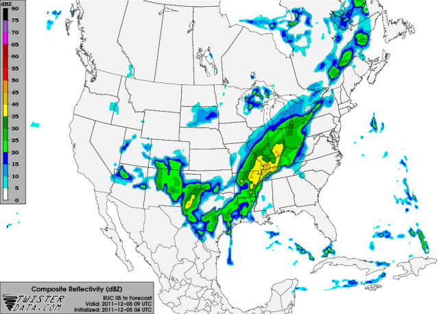
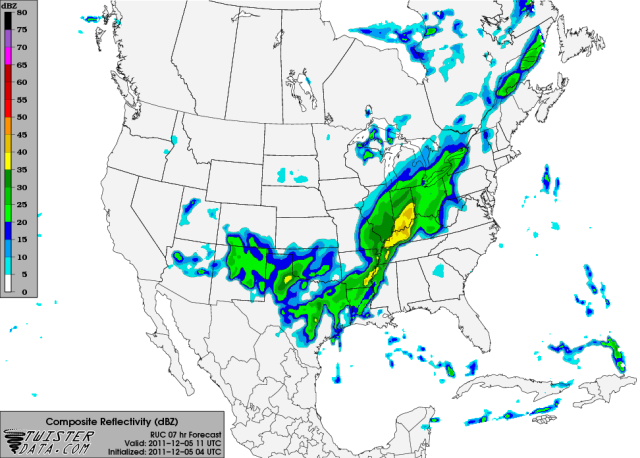
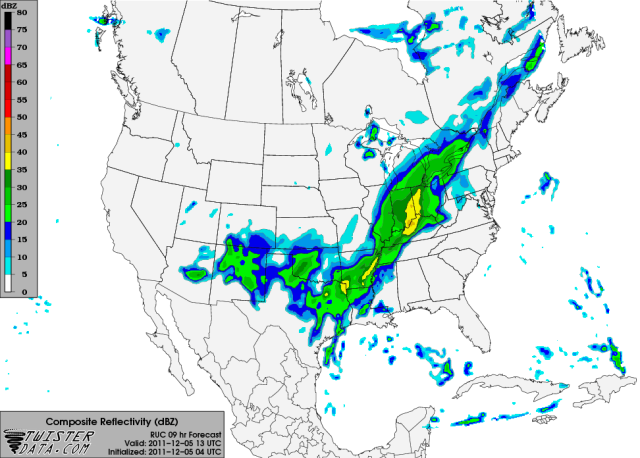
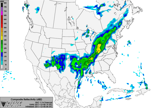
I am really liking the recent radar trends. It looks like there is quite a bit of precipitation to our south and west gradually expanding this way:
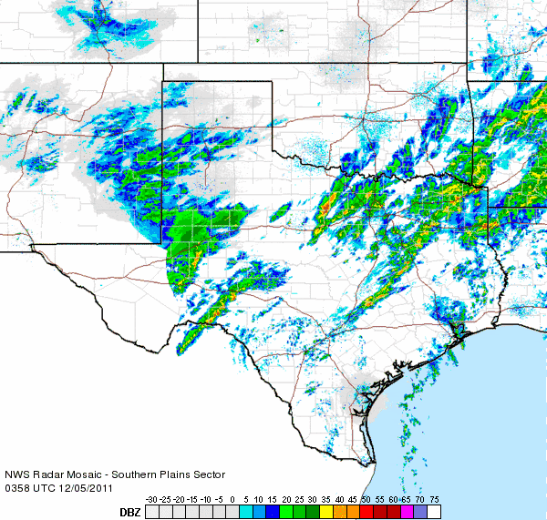
This is a saved loop. It will not refresh with new frames.
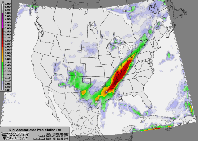
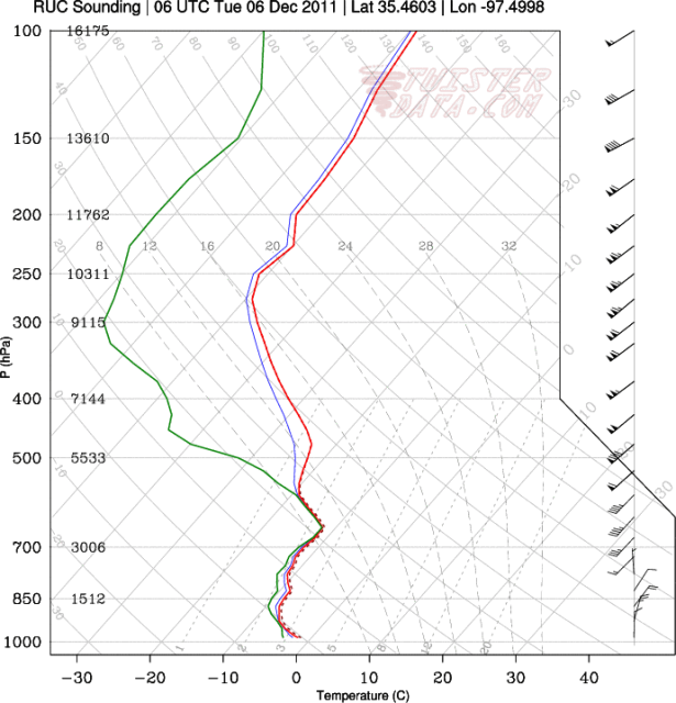
Short-term model guidance has also continued to increase the precipitation over our area tonight, with the latest 4z run of the RUC actually showing measurable precipitation reaching central Oklahoma:
3am RUC simulated reflectivity - http://i43.photobucket.com/albums/e371/ ... URFACE.png
5am RUC simulated reflectivity - http://i43.photobucket.com/albums/e371/ ... URFACE.png
7am RUC simulated reflectivity - http://i43.photobucket.com/albums/e371/ ... URFACE.png
9am RUC simulated reflectivity - http://i43.photobucket.com/albums/e371/ ... URFACE.png
12-hour RUC liquid-equivalent precipitation forecast - http://i43.photobucket.com/albums/e371/ ... _12_HR.png
All in all, I am definitely starting to feel more confident that at least some of us might see flakes tonight. Might just be a few flurries, but that's still something. Hopefully I didn't just jinx it. lol.
*5am Update: Well the precipitation has now "reached us", but it is too dry at the surface for most of it to make it to the ground so far. Could still see a few flurries/light snow showers over the next several hours though if the column can moisten up any or if a slightly heavier band can manage to move through, but overall not looking like this event will be too big a deal.
This is a saved loop. It will not refresh with new frames.
Short-term model guidance has also continued to increase the precipitation over our area tonight, with the latest 4z run of the RUC actually showing measurable precipitation reaching central Oklahoma:
3am RUC simulated reflectivity - http://i43.photobucket.com/albums/e371/ ... URFACE.png
5am RUC simulated reflectivity - http://i43.photobucket.com/albums/e371/ ... URFACE.png
7am RUC simulated reflectivity - http://i43.photobucket.com/albums/e371/ ... URFACE.png
9am RUC simulated reflectivity - http://i43.photobucket.com/albums/e371/ ... URFACE.png
12-hour RUC liquid-equivalent precipitation forecast - http://i43.photobucket.com/albums/e371/ ... _12_HR.png
All in all, I am definitely starting to feel more confident that at least some of us might see flakes tonight. Might just be a few flurries, but that's still something. Hopefully I didn't just jinx it. lol.
*5am Update: Well the precipitation has now "reached us", but it is too dry at the surface for most of it to make it to the ground so far. Could still see a few flurries/light snow showers over the next several hours though if the column can moisten up any or if a slightly heavier band can manage to move through, but overall not looking like this event will be too big a deal.
0 likes
-
TwisterFanatic
- Category 5
- Posts: 1041
- Joined: Mon Jun 28, 2010 12:43 pm
- Location: Sallisaw, Oklahoma
I'm getting some moderate/heavy snow right now. Starting to stick, may have a dusting or a little more by the time it's over.
Nice little change from yesterday when they were thinking nothing would happen.
Nice little change from yesterday when they were thinking nothing would happen.
0 likes
Personal Forecast Disclaimer:
The posts in this forum are NOT official forecast and should not be used as such. They are just the opinion of the poster and may or may not be backed by sound meteorological data. They are NOT endorsed by any professional institution or storm2k.org. For official information, please refer to the NHC and NWS products.
The posts in this forum are NOT official forecast and should not be used as such. They are just the opinion of the poster and may or may not be backed by sound meteorological data. They are NOT endorsed by any professional institution or storm2k.org. For official information, please refer to the NHC and NWS products.
-
TwisterFanatic
- Category 5
- Posts: 1041
- Joined: Mon Jun 28, 2010 12:43 pm
- Location: Sallisaw, Oklahoma
I didn't get much before the Snow shield dissipated rapidly, but places to the South and East of me got up to 3 inches this morning.
The snow definitely setup much further south than the NWS anticipated. Wednesday morning we could see flurries/light now as the Upper Level System passes over the area, moisture looks meager, but It did this morning also.
The snow definitely setup much further south than the NWS anticipated. Wednesday morning we could see flurries/light now as the Upper Level System passes over the area, moisture looks meager, but It did this morning also.
0 likes
Personal Forecast Disclaimer:
The posts in this forum are NOT official forecast and should not be used as such. They are just the opinion of the poster and may or may not be backed by sound meteorological data. They are NOT endorsed by any professional institution or storm2k.org. For official information, please refer to the NHC and NWS products.
The posts in this forum are NOT official forecast and should not be used as such. They are just the opinion of the poster and may or may not be backed by sound meteorological data. They are NOT endorsed by any professional institution or storm2k.org. For official information, please refer to the NHC and NWS products.
-
Extremeweatherguy
- Category 5
- Posts: 11095
- Joined: Mon Oct 10, 2005 8:13 pm
- Location: Houston, TX
It looks like we might have one last shot at snow tonight if the latest short-term model trends verify...
19z HRRR is showing light accumulations for mostly the western 2/3rds of the state:
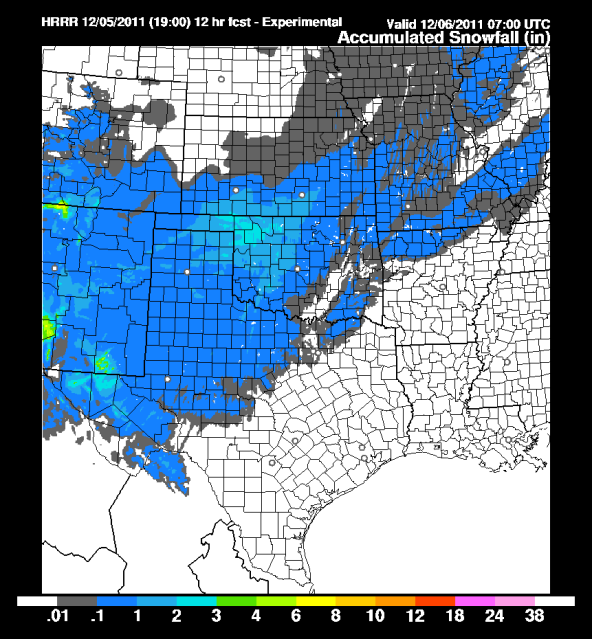
The 20z RUC, which doesn't offer a snow depth map, is also showing widespread light liquid-equivalent accumulations:
The models, and I personally, still think the best shot of snow will be to our north and west; however, these trends cannot be ignored. We will have to watch the radar closely in the coming hours to see if this last wave of snow might impact areas further south and east.
Mid level dry air is still the big negative, as we saw last night and this morning for most of us along and west of I-44 where we basically had a huge virga storm over our heads. However, if the 20z RUC is to be believed, then this dry layer should significantly decrease over the next several hours, helping to get the flakes to the surface:
Current (4pm) - http://i43.photobucket.com/albums/e371/ ... 75000W.png
8pm - http://i43.photobucket.com/albums/e371/ ... 75000W.png
12am - http://i43.photobucket.com/albums/e371/ ... 75000W.png
(sounding location: http://maps.google.com/maps?client=safa ... a=N&tab=wl)
8:00pm update - As has been the case for the past couple of days, subsequent runs of the RUC now look less impressive. Radar trends and the HRRR suggest there might still be some hope though, so we shall see. I am definitely not holding my breath. It looks like we might have to wait for the next storm system to get our chance at some flakes..
12:30am update - So far we have had reports of light snow to our north and west (Watonga, Tulsa, perhaps even El Reno), and we have also had reports of snow to our south (near Dallas). The Oklahoma City to Norman corridor continues to miss out though, and the latest radar trends are not overly positive. As I said above, it appears as though we may have to wait until next time..
19z HRRR is showing light accumulations for mostly the western 2/3rds of the state:
The 20z RUC, which doesn't offer a snow depth map, is also showing widespread light liquid-equivalent accumulations:
The models, and I personally, still think the best shot of snow will be to our north and west; however, these trends cannot be ignored. We will have to watch the radar closely in the coming hours to see if this last wave of snow might impact areas further south and east.
Mid level dry air is still the big negative, as we saw last night and this morning for most of us along and west of I-44 where we basically had a huge virga storm over our heads. However, if the 20z RUC is to be believed, then this dry layer should significantly decrease over the next several hours, helping to get the flakes to the surface:
Current (4pm) - http://i43.photobucket.com/albums/e371/ ... 75000W.png
8pm - http://i43.photobucket.com/albums/e371/ ... 75000W.png
12am - http://i43.photobucket.com/albums/e371/ ... 75000W.png
(sounding location: http://maps.google.com/maps?client=safa ... a=N&tab=wl)
8:00pm update - As has been the case for the past couple of days, subsequent runs of the RUC now look less impressive. Radar trends and the HRRR suggest there might still be some hope though, so we shall see. I am definitely not holding my breath. It looks like we might have to wait for the next storm system to get our chance at some flakes..
12:30am update - So far we have had reports of light snow to our north and west (Watonga, Tulsa, perhaps even El Reno), and we have also had reports of snow to our south (near Dallas). The Oklahoma City to Norman corridor continues to miss out though, and the latest radar trends are not overly positive. As I said above, it appears as though we may have to wait until next time..
0 likes
-
Extremeweatherguy
- Category 5
- Posts: 11095
- Joined: Mon Oct 10, 2005 8:13 pm
- Location: Houston, TX
Well it looks like i'm finally getting my snow, albeit barely. We have had some very small, whispy flakes fluttering through the air for the last few minutes (and supposedly it also happened earlier this morning too according to some I have talked to). It's definitely a true "flurry" event, and barely snow, but i'll take it. At least I saw some flakes. It's so cold outside too that these small flakes aren't melting when they land, so you can see them resting here and there on the cars.
0 likes
-
BlueIce
- S2K Supporter
- Posts: 194
- Age: 35
- Joined: Mon Sep 01, 2008 10:05 pm
- Location: Oklahoma City, Oklahoma
Re:
Extremeweatherguy wrote:Well it looks like i'm finally getting my snow, albeit barely. We have had some very small, whispy flakes fluttering through the air for the last few minutes (and supposedly it also happened earlier this morning too according to some I have talked to). It's definitely a true "flurry" event, and barely snow, but i'll take it. At least I saw some flakes. It's so cold outside too that these small flakes aren't melting when they land, so you can see them resting here and there on the cars.
I had a small area of flurries on my car this morning at about 10:00AM. The worst thing about this system so far has been the cold air that has come down into Oklahoma. The high today was 31F and I do not think we made it out of the upper 20's. I guess its back to model watching to see when the next system may come our way.
0 likes
-
GRAYSONCO.WX
- Category 1

- Posts: 450
- Joined: Thu Jan 06, 2011 4:29 pm
- Location: Denison, Texas
Re: Re:
BlueIce wrote:Extremeweatherguy wrote:Well it looks like i'm finally getting my snow, albeit barely. We have had some very small, whispy flakes fluttering through the air for the last few minutes (and supposedly it also happened earlier this morning too according to some I have talked to). It's definitely a true "flurry" event, and barely snow, but i'll take it. At least I saw some flakes. It's so cold outside too that these small flakes aren't melting when they land, so you can see them resting here and there on the cars.
I had a small area of flurries on my car this morning at about 10:00AM. The worst thing about this system so far has been the cold air that has come down into Oklahoma. The high today was 31F and I do not think we made it out of the upper 20's. I guess its back to model watching to see when the next system may come our way.
Do you think the system late this weekend/early next week could be something to watch in terms of winter precip? Also, do you think some areas could get light snowfall with next front that moves through on Friday? Thank you.
0 likes
-
TwisterFanatic
- Category 5
- Posts: 1041
- Joined: Mon Jun 28, 2010 12:43 pm
- Location: Sallisaw, Oklahoma
THERE IS SOME POTENTIAL FOR A WINTRY MIX OF RAIN...FREEZING AND SLEET
FRIDAY NIGHT AS LOW LEVEL MOISTURE RETURNS TO THE AREA IN ADVANCE OF
AN APPROACHING STORM SYSTEM.
From the Tulsa NWS. Looks rather interesting in about 7-9 days.
FRIDAY NIGHT AS LOW LEVEL MOISTURE RETURNS TO THE AREA IN ADVANCE OF
AN APPROACHING STORM SYSTEM.
From the Tulsa NWS. Looks rather interesting in about 7-9 days.
0 likes
Personal Forecast Disclaimer:
The posts in this forum are NOT official forecast and should not be used as such. They are just the opinion of the poster and may or may not be backed by sound meteorological data. They are NOT endorsed by any professional institution or storm2k.org. For official information, please refer to the NHC and NWS products.
The posts in this forum are NOT official forecast and should not be used as such. They are just the opinion of the poster and may or may not be backed by sound meteorological data. They are NOT endorsed by any professional institution or storm2k.org. For official information, please refer to the NHC and NWS products.
-
Extremeweatherguy
- Category 5
- Posts: 11095
- Joined: Mon Oct 10, 2005 8:13 pm
- Location: Houston, TX
Who is online
Users browsing this forum: No registered users and 42 guests