
The calendar says its December 26th...
Moderator: S2k Moderators
Forum rules
 The posts in this forum are NOT official forecast and should not be used as such. They are just the opinion of the poster and may or may not be backed by sound meteorological data. They are NOT endorsed by any professional institution or STORM2K.

The posts in this forum are NOT official forecast and should not be used as such. They are just the opinion of the poster and may or may not be backed by sound meteorological data. They are NOT endorsed by any professional institution or STORM2K.

I thought La Nina was supposed to bring the upper midwest/northern plains cold and snow? The Dakotas/MN set record highs today jesus...
000
SXUS73 KFGF 262100
RERFGF
RECORD EVENT REPORT
NATIONAL WEATHER SERVICE EASTERN NORTH DAKOTA/GRAND FORKS
303 PM CST MON DEC 26 2011
...RECORD HIGH TEMPERATURES SET SUNDAY AT THE UND/GRAND FORKS NWS
CLIMATE STATION...FARGO HECTOR FIELD AND GRAND FORKS AIRPORT...
A RECORD HIGH TEMPERATURE OF 49 DEGREES WAS SET AT UND/GRAND FORKS
NWS CLIMATE STATION TODAY...DECEMBER 26TH. THIS BREAKS THE OLD
RECORD OF 42 SET IN 1994.
A RECORD HIGH TEMPERATURE OF 51 DEGREES WAS SET AT FARGO HECTOR
INTERNATIONAL AIRPORT TODAY...DECEMBER 26TH. THIS BREAKS THE OLD
RECORD OF 45 SET IN 1959.
A RECORD HIGH TEMPERATURE OF 47 DEGREES WAS SET AT GRAND FORKS
INTERNATIONAL AIRPORT TODAY...DECEMBER 26TH. THIS BREAKS THE OLD
RECORD OF 42 SET IN 2006.
Record High Temperature set at Duluth Today
The temperature at Duluth reached 43 degrees this afternoon at 12:58 pm. This breaks the record high temperature for this date of 42 degrees set in 1908 and 1877.
PUBLIC INFORMATION STATEMENT
NATIONAL WEATHER SERVICE TWIN CITIES/CHANHASSEN MN
409 PM CST MON DEC 26 2011
...TODAYS MAXIMUM TEMPERATURES AND WIND GUST REPORTS FROM CENTRAL AND
SOUTHERN MINNESOTA...AND WEST CENTRAL WISCONSIN...
DAILY RECORD HIGH TEMPERATURES WERE SET AT MINNEAPOLIS AND ST. CLOUD.
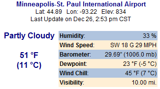
MINNEAPOLIS/ST. PAUL INTERNATIONAL AIRPORT 244 PM DEC 26 52 F
PREVIOUS RECORD: 51 F SET IN 1936
ST. CLOUD 304 PM DEC 26 49 F
PREVIOUS RECORD: 48 F SET IN 1905
0 likes
The above post and any post by Ntxw is NOT an official forecast and should not be used as such. It is just the opinion of the poster and may or may not be backed by sound meteorological data. It is NOT endorsed by any professional institution including Storm2k. For official information, please refer to NWS products.
Help support Storm2K!
-
Extratropical94

- Professional-Met

- Posts: 3535
- Age: 29
- Joined: Wed Oct 20, 2010 6:36 am
- Location: Hamburg, Germany
- Contact:
Well, not every year can be like the one before.
High 40s on Christmas here, everything is green, total snow since November is .4 inches which more or less came down as sleet.
We had 6 nights with below-freezing temperatures so far. Last year (Oct-Dec 2010) we had already seen 26 inches, 51 freezy nights and almost a whole month of temperatures < 0C, even during daytime.
For example, the first week of December 2010 had an average temperature of -4.8 C, the first week of Dec 2011 was +6.3C, that's 11 degrees centigrade or 20F higher than last year.
Stupid NAO is bringing the warm west winds here and there is really NO sign that this pattern will change in the upcoming months.
0 likes
54° 11' 59'' N, 9° 9' 20'' E
Boomer Sooner!
Go Broncos! Go Cards! Go Niners!
- Daniel
Boomer Sooner!
Go Broncos! Go Cards! Go Niners!
- Daniel
-
brunota2003

- S2K Supporter

- Posts: 9476
- Age: 33
- Joined: Sat Jul 30, 2005 9:56 pm
- Location: Stanton, KY...formerly Havelock, NC
- Contact:
Re: The calendar says its December 26th...
From Buffalo NWS AFD:
Code: Select all
.CLIMATE...
THROUGH DECEMBER 29TH TOTAL SNOWFALL TO START THE 2011-12 SEASON
ARE:

BUFFALO     3.8 INCHES
ROCHESTER   5.2 INCHES

WITH THIS NEAR RECORD LOW SNOWFALL THUS FAR FOR THE WINTER OF
2011-12 WE COMPARED OTHER SUCH SLOW STARTS TO WINTERS TO THEIR
ANNUAL SNOWFALL TOTALS. THE 30-YEAR NORMALS PLACE DECEMBER AS THE
SNOWIEST MONTH IN BUFFALO...AND JANUARY FOR ROCHESTER. THE TABLE
BELOW CONTAINS THE LEAST AMOUNT OF SNOW TO START THE WINTER SEASON
THROUGH THE END OF THE YEAR...ALONG WITH THE RESPECTIVE ANNUAL (JULY
THROUGH JUNE) SNOWFALL TOTAL.

BUFFALO

RANK    YEAR     SNOW FALL    ANNUAL TOTAL
                  THROUGH      (INCHES)
                END OF YEAR
                 (INCHES)

  1     1896        3.6         50.2
  2     1931        3.8         49.6
  3     1918        5.8         25.0
  4     1923        6.4         46.7
  5     1888        7.0         67.3
  6     1891        8.0         80.9
  7     1948        8.2         40.1
  8     1994        8.7         74.6
  9     1889        9.1         22.4
 10     1939        9.2         83.6


***NORMAL THROUGH THE END OF THE YEAR: 36.2***
***1981-2010 CLIMATOLOGICAL NORMAL ANNUAL TOTAL IS 94.7***


ROCHESTER

RANK    YEAR     SNOW FALL    ANNUAL TOTAL
                  THROUGH      (INCHES)
                END OF YEAR
                 (INCHES)

  1     1939        2.7         54.5
  2     2006        5.2         107.2
  3     1931        5.9         75.7
  4     1941        6.1         66.3
  5     2001        7.2         58.1
  6     1952        7.5         41.7
  7     1940        7.9         73.7
  8     1932        9.1         29.2
  9     1998        10.2        111.6
 10     1943        10.3        46.1

***NORMAL THROUGH THE END OF THE YEAR: 29.2***
***1981-2010 CLIMATOLOGICAL NORMAL ANNUAL TOTAL IS 99.5***

SNOWFALL RECORDS GO BACK TO THE WINTER OF 1884-85.
0 likes
Who is online
Users browsing this forum: No registered users and 109 guests