Texas Winter 2012-2013
Moderator: S2k Moderators
Forum rules
 The posts in this forum are NOT official forecast and should not be used as such. They are just the opinion of the poster and may or may not be backed by sound meteorological data. They are NOT endorsed by any professional institution or STORM2K.

The posts in this forum are NOT official forecast and should not be used as such. They are just the opinion of the poster and may or may not be backed by sound meteorological data. They are NOT endorsed by any professional institution or STORM2K.
Another thing to look into. The cool down this weekend was first forecasted by the GFS *gasp*. I remember reading JB's tweets a couple week's ago calling it crazybonzo when the euro and cfs were barking warm for this period. My oh my...
0 likes
The above post and any post by Ntxw is NOT an official forecast and should not be used as such. It is just the opinion of the poster and may or may not be backed by sound meteorological data. It is NOT endorsed by any professional institution including Storm2k. For official information, please refer to NWS products.
Help support Storm2K!
Re: Texas Winter 2012-2013
Posted this is talking tropics I'll post again here since it's important for us longterm.
Euro


Euro
0 likes
The above post and any post by Ntxw is NOT an official forecast and should not be used as such. It is just the opinion of the poster and may or may not be backed by sound meteorological data. It is NOT endorsed by any professional institution including Storm2k. For official information, please refer to NWS products.
Help support Storm2K!
Help support Storm2K!
-
Comanche

- Category 1

- Posts: 381
- Age: 52
- Joined: Wed Jul 06, 2005 9:33 am
- Location: Clear Lake City Texas
Re: Texas Winter 2012-2013
Would love to hear some ideas about what this winter is shaping up to look like, not specific Texas, but the CONUS as a whole.... any analogs to look at based on what you guys are seeing with el nino and pdo?? muchas appreciatas!
0 likes
-
Portastorm

- Storm2k Moderator

- Posts: 9787
- Age: 61
- Joined: Fri Jul 11, 2003 9:16 am
- Location: South Austin, TX
- Contact:
Re: Texas Winter 2012-2013
Comanche wrote:Would love to hear some ideas about what this winter is shaping up to look like, not specific Texas, but the CONUS as a whole.... any analogs to look at based on what you guys are seeing with el nino and pdo?? muchas appreciatas!
The Grey Goose-swilling mets at the Portastorm Weather Center are hard at work on a winter forecast, likely to be issued in the next few weeks. Of course, you must use the forecast at your own risk considering the track record (or lack thereof) of said mets.
0 likes
Any forecasts under my name are to be taken with a grain of salt. Get your best forecasts from the National Weather Service and National Hurricane Center.
I'm a certified Advanced SKYWARN-trained spotter and am active on Twitter at @TravisCOSW, a social media partner of the NWS Austin-San Antonio office.
I'm a certified Advanced SKYWARN-trained spotter and am active on Twitter at @TravisCOSW, a social media partner of the NWS Austin-San Antonio office.
The north texas PWC office will put out a forecast shortly after ^. Word is highly advanced fortune cookies has been brought up from scenic sw Austin to aid the mets further north.
0 likes
The above post and any post by Ntxw is NOT an official forecast and should not be used as such. It is just the opinion of the poster and may or may not be backed by sound meteorological data. It is NOT endorsed by any professional institution including Storm2k. For official information, please refer to NWS products.
Help support Storm2K!
Help support Storm2K!
-
Tireman4

- S2K Supporter

- Posts: 5674
- Age: 58
- Joined: Fri Jun 30, 2006 1:08 pm
- Location: Humble, Texas
- Contact:
Re:
Ntxw wrote:The north texas PWC office will put out a forecast shortly after ^. Word is highly advanced fortune cookies has been brought up from scenic sw Austin to aid the mets further north.
Thank goodness. Those tea leaves last year just bombed out. Shoot.
0 likes
-
Texas Snowman

- Storm2k Moderator
- Posts: 6011
- Joined: Fri Jan 25, 2008 11:29 am
- Location: Denison, Texas
The Red River Valley office of the PWC is pretty confident on releasing the following "hints" about our upcoming winter:
1. It WILL BE colder than last winter.
2. There WILL BE more winter weather than last winter.
3. And Wxman57 (a.k.a. "The Heat Miser") will no longer be allowed to draw up the weather maps.

1. It WILL BE colder than last winter.
2. There WILL BE more winter weather than last winter.
3. And Wxman57 (a.k.a. "The Heat Miser") will no longer be allowed to draw up the weather maps.
0 likes
The above post and any post by Texas Snowman is NOT an official forecast and should not be used as such. It is just the opinion of the poster and may or may not be backed by sound meteorological data. It is NOT endorsed by any professional institution including storm2k.org. For official information, please refer to NWS products.

Music to my ears from Larry Cosgrove:
With a shift in the warmest temperatures from the eastern ENSO sectors to the central (3.4) corridor quite evident in the TAO diagrams, the chance for a west to central based weak El Nino episode is growing. If so, with a tendency for the strongest hydrothermal deviations to occur in the first half of the winter with a neutral signal returning in February and March, we could see a colder fall and start to winter over the eastern two-thirds of the U.S. (noting that persistent -NAO styled ridge in northern Canada and Greenland over the summer months).
With a shift in the warmest temperatures from the eastern ENSO sectors to the central (3.4) corridor quite evident in the TAO diagrams, the chance for a west to central based weak El Nino episode is growing. If so, with a tendency for the strongest hydrothermal deviations to occur in the first half of the winter with a neutral signal returning in February and March, we could see a colder fall and start to winter over the eastern two-thirds of the U.S. (noting that persistent -NAO styled ridge in northern Canada and Greenland over the summer months).
0 likes
-
StormClouds63
- Category 2

- Posts: 583
- Age: 60
- Joined: Tue May 13, 2008 11:56 am
- Location: Southwest Louisiana
"Love bugs" ... say the first few today (Sunday, 8/19) here in SW LA. A little earlier than usual. Could this mean a quicker Fall season? Hope so.
Also, this "cool" front passing through this weekend ... if this starts a trend, perhaps an early end as well to hurricane season for NW Gulf coast?
Also, this "cool" front passing through this weekend ... if this starts a trend, perhaps an early end as well to hurricane season for NW Gulf coast?
0 likes
-
somethingfunny

- ChatStaff

- Posts: 3926
- Age: 35
- Joined: Thu May 31, 2007 10:30 pm
- Location: McKinney, Texas
Re: Texas Winter 2012-2013
About that "first cold front" contest....
DFW's high yesterday was 78... at 3:40am! With abundant sunshine and a cool breeze in the afternoon, we reached 76. The low temperature was 67.
It was the first time in EIGHT YEARS (since 2004) that ANY day in August failed to reach 80 degrees at DFW.

I felt like Trick-Or-Treaters were going to scamper across the road at every corner yesterday.
DFW's high yesterday was 78... at 3:40am! With abundant sunshine and a cool breeze in the afternoon, we reached 76. The low temperature was 67.
It was the first time in EIGHT YEARS (since 2004) that ANY day in August failed to reach 80 degrees at DFW.
I felt like Trick-Or-Treaters were going to scamper across the road at every corner yesterday.
0 likes
I am not a meteorologist, and any posts made by me are not official forecasts or to be interpreted as being intelligent. These posts are just my opinions and are probably silly opinions.
-
Rgv20

- S2K Supporter
- Posts: 2456
- Age: 37
- Joined: Wed Jan 05, 2011 5:42 pm
- Location: Edinburg/McAllen Tx
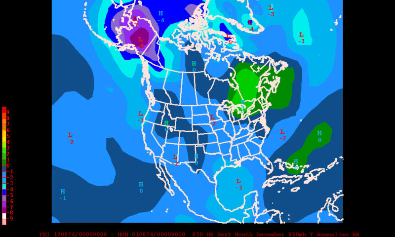
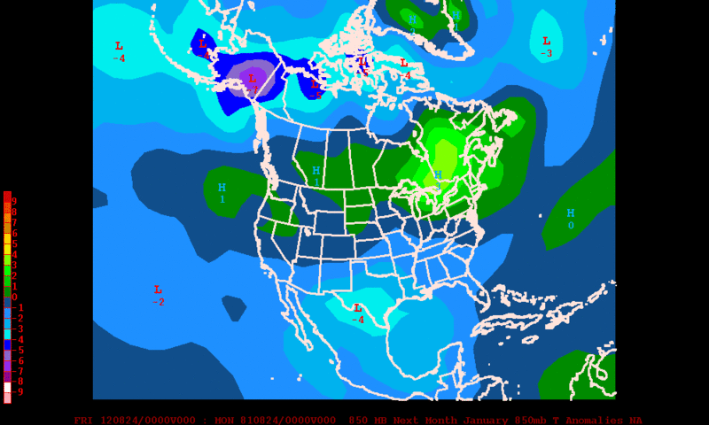
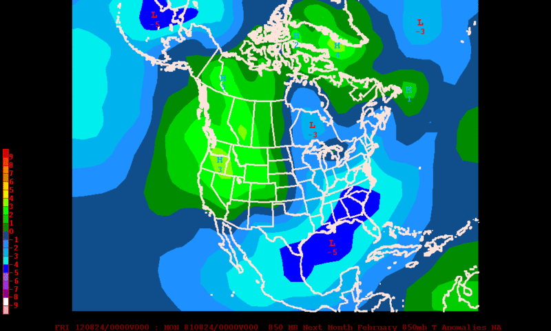
CFS continues to paint a wet and cool winter for most of Texas.....El Nino Rules!
December 850mb Temperature Anomalies
January 850mb Temperature Anomalies
February 850mb Temperature Anomalies
December 850mb Temperature Anomalies
January 850mb Temperature Anomalies
February 850mb Temperature Anomalies
0 likes
The following post is NOT an official forecast and should not be used as such. It is just the opinion of the poster and may or may not be backed by sound meteorological data. It is NOT endorsed by any professional institution including storm2k.org For Official Information please refer to the NHC and NWS products.
Thanks for the post Rgv20! I see it's forecasting for the continuation of -NAO. Sure is a lot blockiness in eastern Canada. Also remember, AO tends to mimic the NAO.
0 likes
The above post and any post by Ntxw is NOT an official forecast and should not be used as such. It is just the opinion of the poster and may or may not be backed by sound meteorological data. It is NOT endorsed by any professional institution including Storm2k. For official information, please refer to NWS products.
Help support Storm2K!
Help support Storm2K!
Re:
Comanche wrote:Would love to hear some thoughts about the moisture charge from Isaac into the south/southeast before El Nino this winter. Will this soil moisture recharge have any possible impacts on winter temperature/precip forecasts?
Don't think so, soil moisture usually just effects summer as humid air doesn't get as hot. Maybe keep your lows a bit warmer in the winter but Isaac doesn't have any implications on winter temps or precip that I know of. Very different weather patterns.
0 likes
The above post and any post by Ntxw is NOT an official forecast and should not be used as such. It is just the opinion of the poster and may or may not be backed by sound meteorological data. It is NOT endorsed by any professional institution including Storm2k. For official information, please refer to NWS products.
Help support Storm2K!
Help support Storm2K!
-
weatherdude1108
- Category 5

- Posts: 4172
- Joined: Tue Dec 13, 2011 1:04 pm
- Location: Northwest Austin/Cedar Park, TX
"STAY TUNED." 
000
FXUS64 KEWX 011957
AFDEWX
AREA FORECAST DISCUSSION
NATIONAL WEATHER SERVICE AUSTIN/SAN ANTONIO TX
257 PM CDT SAT SEP 1 2012
.DISCUSSION...
SHOWERS AND THUNDERSTORMS WILL CONTINUE THROUGH THIS EVENING ALONG
A CONVERGENCE ZONE DRAPED ACROSS THE TEXAS COAST. MOST OF THIS
ACTIVITY WILL REMAIN ACROSS THE COASTAL PLAINS...BUT A FEW COULD
DRIFT AS FAR INLAND AS THE I-35 CORRIDOR. THE STORMS WILL WANE IN
AREAL COVERAGE WITH THE LOSS OF DAYTIME HEATING AND CURRENTLY
EXPECT A LULL IN ACTIVITY OVERNIGHT. THERE IS A CHANCE FOR SHOWERS
AND THUNDERSTORMS AGAIN SUNDAY AFTERNOON...BUT WILL GENERALLY BE
LIMITED TO ISOLATED COVERAGE ALONG THE SEA BREEZE AS UPPER RIDGING
BEGINS TO BUILD INTO THE REGION.
A BENIGN WEATHER PATTERN WILL SETTLE IN FOR THE LABOR DAY HOLIDAY
AND PERSIST THROUGH THE WORKWEEK AS THE SUBTROPICAL RIDGE REMAINS
PERCHED OVER THE SOUTHWESTERN U.S./NRN MEXICO. TEMPERATURES WILL
BE ABOVE AVERAGE FOR EARLY SEPTEMBER...WITH HIGHS GENERALLY A FEW
DEGREES ON EITHER SIDE OF 100 AND LOWS IN THE 70S. THE 12Z RUN OF
THE ECMWF AND GFS STILL SUPPORT A MAJOR CHANGE IN THE UPPER
PATTERN JUST BEYOND THE EXTENT OF THE FORECAST PACKAGE. THE GFS
SUGGESTS THAT AN UPPER TROUGH AXIS STRETCHED ACROSS THE UPPER
PLAINS STATES NEXT WEEKEND WILL DEVELOP INTO A CUT-OFF LOW
ACROSS THE MID-WEST A FEW DAYS LATER. MEANWHILE...THE ECMWF KEEPS
THE TROUGH AXIS CONNECTED TO THE BROADER FLOW ALOFT WITH THE
CENTER OF THE LOW PUSHING ACROSS ONTARIO/QUEBEC AND DRAGS THE COLD
FRONT INTO OUR AREA SOMETIME BETWEEN SEPT 9/10. WHILE THESE
SOLUTIONS ARE DISTINCTLY DIFFERENT...THEY BOTH STILL AGREE ON SOME
SORT OF COLD FRONT FOR OUR AREA SOMETIME BETWEEN 8 TO 10 DAYS FROM
TODAY. STAY TUNED.
0 likes
The preceding post is NOT an official forecast, and should not be used as such. It is only the opinion of the poster and may or may not be backed by sound meteorological data. It is NOT endorsed by any professional institution including storm2k.org. For Official Information please refer to the NHC and NWS products.
-
Janie2006

- Category 5
- Posts: 1293
- Joined: Mon Sep 18, 2006 3:28 pm
- Location: coastal Ms aka home of the hurricanes
The Southeast has already seen a couple of "cool" fronts in August, one of which lowered temperatures in the Tennessee Valley and Northern Alabama into the mid 50s for overnight mins. The front cleared the coast, bringing a real difference in humidity to the northern Gulf Coast. This was about a week or so prior to Isaac. While not unheard of, it is relatively rare for this time of year in that it only seems to happen every few years. Perhaps a harbinger of an early fall.
0 likes
-
vbhoutex

- Storm2k Executive

- Posts: 28974
- Age: 72
- Joined: Wed Oct 09, 2002 11:31 pm
- Location: Spring Branch area, Houston, TX
- Contact:
Re:
Janie2006 wrote:The Southeast has already seen a couple of "cool" fronts in August, one of which lowered temperatures in the Tennessee Valley and Northern Alabama into the mid 50s for overnight mins. The front cleared the coast, bringing a real difference in humidity to the northern Gulf Coast. This was about a week or so prior to Isaac. While not unheard of, it is relatively rare for this time of year in that it only seems to happen every few years. Perhaps a harbinger of an early fall.
We are hoping!! The last front, which did clear the coast here also, didn't really do anything except make it drier. Hopefully this one will actually drop temps for us here in TX.
0 likes
Skywarn, C.E.R.T.
Please click below to donate to STORM2K to help with the expenses of keeping the site going:

Please click below to donate to STORM2K to help with the expenses of keeping the site going:
Re: Texas Winter 2012-2013
Alright now that it's September it's time to put out my thoughts and forecast for winter(Sorry Porta I'm taking a jump before you  )
)
ENSO
Current values indicate weak El Nino may have taken hold. After looking at analog years with Nino's after Nina or Neutral couplet I believe our best fit situation is a low end moderate El Nino. Peaking around 1.0c - 1.3c anywhere from October to December is my pick.
It is also evident that it will be Central Based Nino in regions 3.4 defined by 120-170W.
Analog Years for DJF (Meteorological winter)
Best Fit: 1976-1977, 2002-2003
Temps for those two seasons


Honorable Mentions - These two seasons were El Ninos after Ninas but were higher end moderate. Also had a lot of blocking.
2009-2010
1957-1958

Summary
So all in all what does this mean? It's likely to be a colder than average winter for Texas and surrounding states. Wettest areas will be the southern half of the state. The two best fit analogs suggest December will be the fun month with a quiet period in January. February could be average with a cold shot. Overall winter in terms of precip normal to slightly above normal statewide, wettest to the south less wet to the north (this is not snowfall just overall precip, colder temps can have above snow even with less precip).
One big caveat is blocking. 1957-1958, 2009-2010 was pretty much wall to wall cold with a pronounced -AO and -NAO. If these two features exists this year January and February could be very cold as well. Unfortunately they are hard to predict this time of year and we will know probably Oct or Nov. So right now it's best to stick with the more conservative solution.
Last season the analog years screamed warm and snowless (1975-1976, 2001-2002, 2008-2009), but being a cold monger I disregarded it. This year the analogs are much friendlier.
Let it snow, Let it snow, Let it snow
_____________________________________
Disclaimer: I am not responsible for any disappointments due to lack of delivery. I am just a wing of the PWC forecast center so any questions or concerns please direct them toward the chief forecaster. All forecasts are final, not valid in Austin or Wxman57's house (omega blocks).
ENSO
Current values indicate weak El Nino may have taken hold. After looking at analog years with Nino's after Nina or Neutral couplet I believe our best fit situation is a low end moderate El Nino. Peaking around 1.0c - 1.3c anywhere from October to December is my pick.
It is also evident that it will be Central Based Nino in regions 3.4 defined by 120-170W.
Analog Years for DJF (Meteorological winter)
Best Fit: 1976-1977, 2002-2003
Temps for those two seasons
Honorable Mentions - These two seasons were El Ninos after Ninas but were higher end moderate. Also had a lot of blocking.
2009-2010
1957-1958
Summary
So all in all what does this mean? It's likely to be a colder than average winter for Texas and surrounding states. Wettest areas will be the southern half of the state. The two best fit analogs suggest December will be the fun month with a quiet period in January. February could be average with a cold shot. Overall winter in terms of precip normal to slightly above normal statewide, wettest to the south less wet to the north (this is not snowfall just overall precip, colder temps can have above snow even with less precip).
One big caveat is blocking. 1957-1958, 2009-2010 was pretty much wall to wall cold with a pronounced -AO and -NAO. If these two features exists this year January and February could be very cold as well. Unfortunately they are hard to predict this time of year and we will know probably Oct or Nov. So right now it's best to stick with the more conservative solution.
Last season the analog years screamed warm and snowless (1975-1976, 2001-2002, 2008-2009), but being a cold monger I disregarded it. This year the analogs are much friendlier.
Let it snow, Let it snow, Let it snow
_____________________________________
Disclaimer: I am not responsible for any disappointments due to lack of delivery. I am just a wing of the PWC forecast center so any questions or concerns please direct them toward the chief forecaster. All forecasts are final, not valid in Austin or Wxman57's house (omega blocks).
0 likes
The above post and any post by Ntxw is NOT an official forecast and should not be used as such. It is just the opinion of the poster and may or may not be backed by sound meteorological data. It is NOT endorsed by any professional institution including Storm2k. For official information, please refer to NWS products.
Help support Storm2K!
Help support Storm2K!
-
Portastorm
- Storm2k Moderator
- Posts: 9787
- Age: 61
- Joined: Fri Jul 11, 2003 9:16 am
- Location: South Austin, TX
- Contact:
Re: Texas Winter 2012-2013
Ntxw, that is a nice forecast. Good graphics and explanation. Of course, all of us outside of a few heat misers around here hope you'll be spot on with your forecast! Good luck on your forecast.
I hope to have my thoughts together in a somewhat cogent posting some time in the next week. I will say thay my take on this coming winter for Texas isn't as quite as enthusiastic as yours but it's along those lines.
I hope to have my thoughts together in a somewhat cogent posting some time in the next week.
0 likes
Any forecasts under my name are to be taken with a grain of salt. Get your best forecasts from the National Weather Service and National Hurricane Center.
I'm a certified Advanced SKYWARN-trained spotter and am active on Twitter at @TravisCOSW, a social media partner of the NWS Austin-San Antonio office.
I'm a certified Advanced SKYWARN-trained spotter and am active on Twitter at @TravisCOSW, a social media partner of the NWS Austin-San Antonio office.
-
somethingfunny
- ChatStaff
- Posts: 3926
- Age: 35
- Joined: Thu May 31, 2007 10:30 pm
- Location: McKinney, Texas
Re: Texas Winter 2012-2013
Ntxw wrote:Analog Years for DJF (Meteorological winter)
Best Fit: 1976-1977, 2002-2003
Honorable Mentions - These two seasons were El Ninos after Ninas but were higher end moderate. Also had a lot of blocking.
2009-2010
1957-1958
One big caveat is blocking. 1957-1958, 2009-2010 was pretty much wall to wall cold with a pronounced -AO and -NAO. If these two features exists this year January and February could be very cold as well. Unfortunately they are hard to predict this time of year and we will know probably Oct or Nov. So right now it's best to stick with the more conservative solution.
Last season the analog years screamed warm and snowless (1975-1976, 2001-2002, 2008-2009), but being a cold monger I disregarded it. This year the analogs are much friendlier.
Let it snow, Let it snow, Let it snow
_____________________________________
Disclaimer: I am not responsible for any disappointments due to lack of delivery. I am just a wing of the PWC forecast center so any questions or concerns please direct them toward the chief forecaster. All forecasts are final, not valid in Austin or Wxman57's house (omega blocks).
I like your analogs
The only one of your four analog winters without a significant North Texas snow event was 1957-1958.
http://www.srh.noaa.gov/fwd/?n=dsnows
November 13-14, 1976 Widespread 4-6 inch snow fell over much of the northern and western sections of North Texas. The area covered was north of a line through Coleman, Hamilton, Fort Worth, Bonham, and Clarksville. Lampasas also reported 5 inches of snow with this event.
January 30, 1977 Almost all of North Texas picked up at least 2 inches of snow with this event. Between 4-6 inches were reported south of the Red River and north of a line through Eastland, Hillsboro, Fairfield, and Tyler.
February 24-27, 2003 This was a widespread freezing rain, sleet, and snow event, with ice to the south and snow to the north. Accumulations were generally 3-5 inches over the northern third of the area, and 1-3 inches over the middle third. In Central Texas and adjacent portions of Southeast Texas, ice accumulated to between ¼-½ inch.
December 24, 2009 A powerful upper level low brought near blizzard conditions to North Texas on Christmas Eve. Winds gusted to 40 to 50 mph while snow was falling resulting in very low visibilities and blowing snow. Snow began to fall in the late morning hours and become most intense during the afternoon. Snowfall amounts were heaviest northwest of the Metroplex where Graham and Bowie recorded 6 to 9 inches of snow. From Comanche to the DFW Metroplex into the Sherman/Denison area, 2 to 3 inches of snow fell. This snow remained on the ground the next morning, giving many areas a white Christmas.
February 11-12, 2010
Record breaking snow fell across North Central Texas. Cold air was already in place when a slow moving upper level low approached. The low slowed significantly as it got closer to the region, and this allowed relatively warm and moist air to move over the colder air at the surface for an extended period of time. This very unusual event brought snowfall totals of a foot or more for many locations around the DFW Metroplex. Haslet reported 14.4 inches, while DFW Airport had a record breaking 12.5 inches in 24 hours. Widespread power outages resulted from the heavy snow, weighing down tree limbs and breaking transmission lines. Clean up from the tree damage lasted for weeks.
February 23, 2010
A strong upper level low pressure system tracked across Central Texas and brought a significant snow event to the region. The highest accumulations of 3 to 5 inches occurred south of I-20 near where the center of the upper low tracked. Snow began in the Hill Country during the early morning hours. Heavy snow spread across Central Texas and moved into East Texas during the afternoon hours before ending.
March 20-21, 2010
An unusually strong and cold upper level low slowly moved along the Red River Valley on March 20 and 21. Heavy snowfall occurred on the backside of the low with measurable snowfall occurring mainly to the north of I-20. A very localized and heavy band of snow developed during the early morning hours of the 21st, dumping 5 to 9 inches of snow across Collin County. Some locations just 20 miles to the southwest of this band of snow only picked up 1 inch. Snow continued into the early afternoon hours on the 21st across East Texas before ending.
0 likes
I am not a meteorologist, and any posts made by me are not official forecasts or to be interpreted as being intelligent. These posts are just my opinions and are probably silly opinions.
Who is online
Users browsing this forum: No registered users and 201 guests