Post-Sandy Nor'easter - November 7-8
Moderator: S2k Moderators
Forum rules
 The posts in this forum are NOT official forecast and should not be used as such. They are just the opinion of the poster and may or may not be backed by sound meteorological data. They are NOT endorsed by any professional institution or STORM2K.

The posts in this forum are NOT official forecast and should not be used as such. They are just the opinion of the poster and may or may not be backed by sound meteorological data. They are NOT endorsed by any professional institution or STORM2K.
-
CrazyC83
- Professional-Met

- Posts: 33393
- Joined: Tue Mar 07, 2006 11:57 pm
- Location: Deep South, for the first time!
Post-Sandy Nor'easter - November 7-8
Created a new threat for this coming storm. Hope it misses out to sea, but the chances are low. If there are any chances of this going tropical, it can be moved there.
0 likes
-
brunota2003

- S2K Supporter

- Posts: 9476
- Age: 33
- Joined: Sat Jul 30, 2005 9:56 pm
- Location: Stanton, KY...formerly Havelock, NC
- Contact:
I'm supposed to final out of the Army Thursday, and then fly home to Kentucky Friday...Fort Drum doesn't want me to escape!!!
Wednesday Night:
Snow likely. Cloudy, with a low around 30. Chance of precipitation is 60%.
Thursday:
Rain and snow likely. Cloudy, with a high near 38. Chance of precipitation is 60%.
Thursday Night:
Snow likely. Mostly cloudy, with a low around 31. Chance of precipitation is 60%.
Friday:
Partly sunny, with a high near 41.
If Thursday's highs drop just a few degrees, it could be all snow, and depending on how much falls, that could adversely impact my plans.
0 likes
Just a small town southern boy helping other humans.
-
angelwing

- S2K Supporter
- Posts: 4462
- Age: 62
- Joined: Tue Jan 18, 2005 3:06 pm
- Location: Kulpsville, PA
Re: Post-Sandy Nor'easter threat - November 6-9
TY for the thread, still dealing with the after effects here and have to keep updated on this threat
Hope u get home soon!!!
Hope u get home soon!!!
0 likes
-
brunota2003
- S2K Supporter
- Posts: 9476
- Age: 33
- Joined: Sat Jul 30, 2005 9:56 pm
- Location: Stanton, KY...formerly Havelock, NC
- Contact:
-
wxman57

- Moderator-Pro Met

- Posts: 22482
- Age: 66
- Joined: Sat Jun 21, 2003 8:06 pm
- Location: Houston, TX (southwest)
Re: Post-Sandy Nor'easter threat - November 6-9
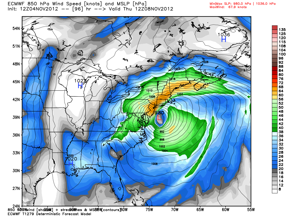
12Z Euro even stronger than 00Z - 40-50 kt winds (with higher gusts) into coastal NJ and Long Island Wednesday afternoon/evening. Could cause tides 3-4 ft above normal and additional power outages over a large area.
0 likes
-
CrazyC83
- Professional-Met
- Posts: 33393
- Joined: Tue Mar 07, 2006 11:57 pm
- Location: Deep South, for the first time!
Re: Post-Sandy Nor'easter threat - November 6-9
wxman57 wrote:12Z Euro even stronger than 00Z - 40-50 kt winds (with higher gusts) into coastal NJ and Long Island Wednesday afternoon/evening. Could cause tides 3-4 ft above normal and additional power outages over a large area.
That would be a surge of about 8 feet into the Battery?
0 likes
-
cycloneye

- Admin

- Posts: 139073
- Age: 67
- Joined: Thu Oct 10, 2002 10:54 am
- Location: San Juan, Puerto Rico
Re: Post-Sandy Nor'easter threat - November 6-9

0 likes
Visit the Caribbean-Central America Weather Thread where you can find at first post web cams,radars
and observations from Caribbean basin members Click Here
and observations from Caribbean basin members Click Here
-
brunota2003
- S2K Supporter
- Posts: 9476
- Age: 33
- Joined: Sat Jul 30, 2005 9:56 pm
- Location: Stanton, KY...formerly Havelock, NC
- Contact:

Re: Post-Sandy Nor'easter threat - November 6-9
While I think the naming thing is not a bad idea, I think it is too soon after 'Sandy' to start naming noreasters...but that probably going to get into the main stream media, as TWC has that type of clout. So we will start hearing about "Winter Storm Xerxes" or something like that fairly soon I suppose...
0 likes
-
jaxfladude
- Category 5

- Posts: 1246
- Joined: Wed Aug 24, 2005 9:36 pm
- Location: Jacksonville, Fla
Re: Post-Sandy Nor'easter threat - November 6-9
 Thoughts with those suffering...
0 likes
Stay safe y'all
-
wxman57
- Moderator-Pro Met
- Posts: 22482
- Age: 66
- Joined: Sat Jun 21, 2003 8:06 pm
- Location: Houston, TX (southwest)
Re: Post-Sandy Nor'easter threat - November 6-9
CrazyC83 wrote:wxman57 wrote:12Z Euro even stronger than 00Z - 40-50 kt winds (with higher gusts) into coastal NJ and Long Island Wednesday afternoon/evening. Could cause tides 3-4 ft above normal and additional power outages over a large area.
That would be a surge of about 8 feet into the Battery?
No, no, no. The wind direction would be from the NE-ENE not SE-SSE. It would pile water up north of western Long Island, but not from the south into The Battery. Could definitely cause additional damage to power lines from southern Maryland through Long Island to eastern MA.
0 likes

Re: Post-Sandy Nor'easter threat - November 6-9
wxman57 wrote:12Z Euro even stronger than 00Z - 40-50 kt winds (with higher gusts) into coastal NJ and Long Island Wednesday afternoon/evening. Could cause tides 3-4 ft above normal and additional power outages over a large area.
Great....flying from Texas to Philadelphia in the morning. Will be in Atlantic City for two weeks for work. Ugh....power outages.
0 likes
-
jlauderdal
- S2K Supporter
- Posts: 6771
- Joined: Wed May 19, 2004 5:46 am
- Location: NE Fort Lauderdale
- Contact:
-
jlauderdal
- S2K Supporter
- Posts: 6771
- Joined: Wed May 19, 2004 5:46 am
- Location: NE Fort Lauderdale
- Contact:
Re:
modeling is clustered, not too much mystery with this system...if i didnt have power i would prepare myself for an extension of no power...if i had power i would prepare myself for life without power..be good to see a much larger govt presence in advance of this one, no point in saving the resources for a rainy day, its pouring...we deal with this stuff in Florida but big difference is the temp...also, those electrical lines are being put up real fast and might not be as stable as they otherwise would be, the idea is you get everything running real fast and come back later and finish it offCrazyC83 wrote:The big unknowns: intensity and location. The CMC I believe bombed it all the way to about 960mb then hooked it west - that would definitely be a worst-case scenario.
0 likes

Re:
tina25 wrote:What is the timeframe for this storm? I'm supposed to be flying out of Newark Wednesday at 1:30 and this really cannot disrupt.
You'll be fine. Looks like a Wednesday night/Thursday event.
0 likes
-
wxman57
- Moderator-Pro Met
- Posts: 22482
- Age: 66
- Joined: Sat Jun 21, 2003 8:06 pm
- Location: Houston, TX (southwest)
Re: Post-Sandy Nor'easter threat - November 6-9
00Z Euro has 8-10" snow into Baltimore/D.C. area from 15Z Wed to 15Z Thu. Up to 14" west of there.
0 likes
Who is online
Users browsing this forum: No registered users and 214 guests