Texas Winter 2013-2014

Winter Weather Discussion

Moderator: S2k Moderators

Forum rules

The posts in this forum are NOT official forecast and should not be used as such. They are just the opinion of the poster and may or may not be backed by sound meteorological data. They are NOT endorsed by any professional institution or STORM2K.

Help Support Storm2K
Message
Author
User avatar
dhweather
S2K Supporter
S2K Supporter
Posts: 6163
Joined: Sat Aug 14, 2004 9:29 pm
Location: Heath, TX
Contact:

Re: Texas Winter 2013-2014

#9921 Postby dhweather » Fri Mar 14, 2014 1:26 pm

Image

Image

I hope the rain materializes. I'm tired of being Lucy'd
0 likes   
The above post and any post by dhweather is NOT an official forecast and should not be used as such. It is just the opinion of the poster and may or may not be backed by sound meteorological data. It is NOT endorsed by any professional institution including storm2k.org. For official information, please refer to NWS products.

User avatar
TheProfessor
Professional-Met
Professional-Met
Posts: 3505
Age: 27
Joined: Tue Dec 03, 2013 10:56 am
Location: Wichita, Kansas

#9922 Postby TheProfessor » Fri Mar 14, 2014 3:32 pm

Wow!, I can't remember the last time NWS FWD has had our rain chances at 100% a whole 24 hours before an event!
0 likes   
An alumnus of The Ohio State University.

Your local National Weather Service office is your best source for weather information.

User avatar
Texas Snowman
Storm2k Moderator
Storm2k Moderator
Posts: 6011
Joined: Fri Jan 25, 2008 11:29 am
Location: Denison, Texas

#9923 Postby Texas Snowman » Fri Mar 14, 2014 4:01 pm

:uarrow: Attention ladies and gentleman, our beloved Heat Miser has been found alive and well. Rumors of his demise have been greatly exaggerated.

I think he just might have called Ntxw a wish caster!!! :D
0 likes   
The above post and any post by Texas Snowman is NOT an official forecast and should not be used as such. It is just the opinion of the poster and may or may not be backed by sound meteorological data. It is NOT endorsed by any professional institution including storm2k.org. For official information, please refer to NWS products.

User avatar
Texas Snowman
Storm2k Moderator
Storm2k Moderator
Posts: 6011
Joined: Fri Jan 25, 2008 11:29 am
Location: Denison, Texas

#9924 Postby Texas Snowman » Fri Mar 14, 2014 4:16 pm

NWS says 33 for Denison on Sunday night. Can we squeeze out another freeze?
0 likes   
The above post and any post by Texas Snowman is NOT an official forecast and should not be used as such. It is just the opinion of the poster and may or may not be backed by sound meteorological data. It is NOT endorsed by any professional institution including storm2k.org. For official information, please refer to NWS products.

User avatar
dhweather
S2K Supporter
S2K Supporter
Posts: 6163
Joined: Sat Aug 14, 2004 9:29 pm
Location: Heath, TX
Contact:

#9925 Postby dhweather » Fri Mar 14, 2014 4:25 pm

Great discussion from FWD:


AREA FORECAST DISCUSSION
NATIONAL WEATHER SERVICE FORT WORTH TX
339 PM CDT FRI MAR 14 2014

.DISCUSSION...
SOUTHERLY WINDS HAVE BROUGHT MOISTURE AND LOW CLOUDS INTO THE AREA
TODAY AND THIS WILL CONTINUE INTO TONIGHT. BY TOMORROW MORNING
ABUNDANT LOW STRATUS WILL BE IN PLACE WITH DEWPOINTS ALSO AROUND
60 DEGREES. LOWS TONIGHT WILL BE UNSEASONABLY MILD AND IN THE MID
TO UPPER 50S. WHILE A FEW LIGHT SHOWERS MAY BE POSSIBLE TONIGHT...
A STRONG INVERSION...OR CAP...NEAR 850MB WILL BE IN PLACE WHICH
WILL INHIBIT DEEP CONVECTION AND THUNDERSTORM POTENTIAL UNTIL
THIS CAN BE ERODED THROUGH LIFTING AND DAYTIME HEATING TOMORROW.

A COMPACT BUT POTENT SHORTWAVE TROUGH WILL MOVE THROUGH NORTH
TEXAS TOMORROW. THIS FEATURE IS DEPICTED ON WATER VAPOR CURRENTLY
OVER THE SONORA DESERT AND SHOULD ARRIVE INTO WEST TEXAS BY MID
MORNING. THIS MEANS STRONG FORCING FOR ASCENT WILL SPREAD ACROSS
NORTH TEXAS DURING THE AFTERNOON HOURS. THIS FORCING WILL HELP
LIFT AND ERODE THE CAP COMPLETELY ACROSS THE NORTHERN HALF OF THE
CWA...WHILE KEEPING A SMALL...BUT BREAKABLE CAP OVER THE SOUTHERN
PARTS OF THE FORECAST AREA. MAINLY CLOUDY SKIES WILL PREVAIL
TOMORROW...WHICH WILL LIMIT ANY STRONG HEATING...BUT STILL SURFACE
THETA-E WILL CLIMB AS THE TEMPS REACH 70 DEGREES WITH DEWPOINTS
NEAR 60. THIS WILL PUT SBCAPE IN THE 500 TO 1000 J/KG RANGE ACROSS
THE REGION. OVER THE SOUTHWEST ZONES WHERE THERE IS A BETTER
CHANCE OF SOME MID-AFTERNOON BREAKS IN THE CLOUDS...CAPE MAY
INCREASE TO 1500 J/KG AS TEMPS REACH THE LOW TO MID 70S. DEEP
LAYER SHEAR WILL BE STRONGEST ACROSS THE SOUTHERN ZONES WHERE A
50+ KNOT SPEED MAX AT 500MB WILL ROTATE AROUND THE BASE OF THE
SHORTWAVE TROUGH. DEEP LAYER SHEAR TAPERS OFF FARTHER TO THE
NORTH WITH THE RED RIVER COUNTIES LIKELY BELOW THE CAPE/SHEAR
COMBINATION THRESHOLD FOR ORGANIZED SEVERE WEATHER.

SINCE FORCING FROM THIS SHORTWAVE IS SO STRONG AND THE CAP WILL BE
COMPLETELY GONE OVER THE NORTHERN HALF OF THE CWA...IT IS LIKELY
CONVECTIVE INITIATION WILL SPONTANEOUSLY OCCUR AHEAD OF THE DRY
LINE OR COLD FRONT AROUND MIDDAY IN THE ABILENE AND GRAHAM REGION.
THIS CONVECTIVE ACTIVITY WILL LIKELY GROW UPSCALE INTO A
CONVECTIVE COMPLEX OR PERHAPS A SMALL SQUALL LINE THAT TRACKS
EAST/NORTHEAST INTO THE METROPLEX BY MID AFTERNOON AND INTO THE
EASTERN ZONES BY EARLY EVENING. THE PRIMARY THREAT WITH THIS
ACTIVITY WILL BE DAMAGING WINDS AND QUARTER SIZE HAIL. FARTHER TO
THE SOUTH...GENERALLY SOUTH OF A COMANCHE TO HILLSBORO LINE...IS
WHERE A SMALL AMOUNT OF CIN WILL REMAIN DUE TO SLIGHTLY LESS
DYNAMIC FORCING IN THIS REGION. IN ADDITION...STRONGER SHEAR AND
HIGHER INSTABILITY IN THIS AREA WOULD FAVOR SUPERCELL STORMS.
THESE SUPERCELLS MAY WAIT UNTIL MID-LATE AFTERNOON TO INITIATE
WHEN THE DRY LINE BEGINS TO IMPINGE ON THE SOUTHWEST ZONES AND
PROVIDES THE LOCALIZED FORCING REQUIRED TO BREAK THE WEAK CAP.
SUPERCELL THUNDERSTORMS WOULD CARRY AN ENHANCED RISK OF SEVERE
WEATHER...WITH HAIL UP TO GOLFBALL SIZE...DAMAGING WINDS...AND
EVEN AN ISOLATED TORNADO WOULD BE POSSIBLE. THESE STORMS SHOULD
EVENTUALLY FILL INTO A LINE AS IT REACHES I-45...WITH MORE OF A
WIND THREAT DEVELOPING OVER THE SOUTHEAST ZONES SATURDAY EVENING.

FOR THE PUBLIC FORECAST WILL MENTION SEVERE STORMS IN THE ZONES
FOR MOST LOCATIONS EXCEPT FOR THE NORTHERN TWO ROWS OF COUNTIES.
RAINFALL AMOUNTS AND COVERAGE WILL BE HIGHEST ALONG AND NORTH OF
I-20 WHERE AVERAGE RAIN TOTALS OF A HALF INCH TO INCH ARE
POSSIBLE...WITH LOCALLY HIGHER AMOUNTS. OVER THE SOUTHERN HALF OF
THE AREA...COVERAGE WILL PROBABLY BE LESS CONTINUOUS THUS RAIN
AMOUNTS WILL VARY DEPENDING ON THUNDERSTORM TRACKS. ALL OF THIS
CONVECTIVE ACTIVITY SHOULD END WEST TO EAST DURING THE EVENING.

A COLD FRONT WILL MOVE THROUGH IN THE WAKE OF THE SHORTWAVE TROUGH
SATURDAY NIGHT. WIND SPEEDS WILL INCREASE TO 20 TO 30 MPH SUNDAY
AND COLD ADVECTION WILL BE QUITE STRONG. TEMPERATURES WILL FAIL TO
WARM MUCH DURING THE DAY SUNDAY WITH HIGHS IN THE LOW TO MID
50S...BUT TEMPS COULD EVEN FALL BACK INTO THE 40S DURING THE DAY.
WILL MAINTAIN A 20 PERCENT CHANCE OF ELEVATED RAIN SHOWERS SUNDAY.
THE NAM AND CANADIAN ARE MOST AGGRESSIVE WITH SUNDAY PRECIPITATION
AND COLDER TEMPERATURES AS THEY TRACK A SECOND UPPER LEVEL SYSTEM
OVER NORTHEAST TEXAS...WHILE THE OTHER GUIDANCE KEEPS THE TRACK
MORE OVER CENTRAL TEXAS. IF THE NAM/CANADIAN WERE TO VERIFY...WE
WOULD HAVE TO LOWER TEMPS AND ALSO ENTERTAIN THE POSSIBILITY OF A
RAIN/SNOW MIX OVER THE NORTHEAST ZONES. RIGHT NOW THESE MODELS ARE
TREATED AS OUTLIERS...BUT IT SHOWS JUST HOW DEPENDENT THE SUNDAY
FORECAST IS ON THE EXACT TARCK OF THE UPPER LEVEL ENERGY.

CLOUDS WILL CLEAR BY SUNDAY EVENING FROM NORTHWEST TO SOUTHEAST
AND HIGH PRESSURE WILL BUILD IN BY SUNRISE MONDAY. TEMPS MAY FLIRT
WITH FREEZING OVER NORTHWEST PARTS OF THE CWA DEPENDING ON HOW
LIGHT WINDS GET. SOUTH WINDS RETURN BY MONDAY AFTERNOON AND
SUNSHINE WILL HELP TEMPS WARM INTO THE UPPER 50S EAST TO UPPER 60S
WEST. SOUTHWEST WINDS INCREASE INTO TUESDAY AHEAD OF ANOTHER FRONT
THAT SHOULD MOVE THROUGH TUESDAY NIGHT. TUESDAY SHOULD BE WARM
WITH HIGHS POSSIBLY PUSHING 80 DEGREES AND SOME FIRE WEATHER
CONCERNS DUE TO LOW HUMIDITY AND BREEZY WINDS. BEHIND THE MIDWEEK
FRONT DRY AND TRANQUIL WEATHER WILL PREVAIL. TEMPERATURES WILL BE
NEAR SEASONABLE NORMALS. RETURN FLOW SHOULD ARRIVE BY NEXT
FRIDAY...WITH PERHAPS ANOTHER SHOT AT SOME RAIN NEXT WEEKEND.
0 likes   
The above post and any post by dhweather is NOT an official forecast and should not be used as such. It is just the opinion of the poster and may or may not be backed by sound meteorological data. It is NOT endorsed by any professional institution including storm2k.org. For official information, please refer to NWS products.

User avatar
Tireman4
S2K Supporter
S2K Supporter
Posts: 5674
Age: 58
Joined: Fri Jun 30, 2006 1:08 pm
Location: Humble, Texas
Contact:

Re:

#9926 Postby Tireman4 » Fri Mar 14, 2014 7:20 pm

Texas Snowman wrote::uarrow: Attention ladies and gentleman, our beloved Heat Miser has been found alive and well. Rumors of his demise have been greatly exaggerated.

I think he just might have called Ntxw a wish caster!!! :D


Well, I never. That is it. Dadgummit, I hope this summer is the coldest on record. :) Freeze Mr. Cyclist, Freeze!!!
0 likes   

Ntxw
Storm2k Moderator
Storm2k Moderator
Posts: 21500
Joined: Wed Oct 21, 2009 6:34 pm
Location: DFW, Texas

Re: Texas Winter 2013-2014

#9927 Postby Ntxw » Fri Mar 14, 2014 8:18 pm

From whence it came, howling from the North. The ghost of March 2010 haunts wxman57.

Image

Image

I'd prefer being called an opportunistic optimist!
0 likes   
The above post and any post by Ntxw is NOT an official forecast and should not be used as such. It is just the opinion of the poster and may or may not be backed by sound meteorological data. It is NOT endorsed by any professional institution including Storm2k. For official information, please refer to NWS products.

  Help support Storm2K!
Help Support Storm2K

User avatar
TheProfessor
Professional-Met
Professional-Met
Posts: 3505
Age: 27
Joined: Tue Dec 03, 2013 10:56 am
Location: Wichita, Kansas

#9928 Postby TheProfessor » Fri Mar 14, 2014 8:28 pm

:uarrow: Wait, is that for tomorrow or Monday.
0 likes   
An alumnus of The Ohio State University.

Your local National Weather Service office is your best source for weather information.

TarrantWx
Category 1
Category 1
Posts: 287
Age: 38
Joined: Thu Jan 30, 2014 10:38 am
Location: Keller, TX

Re:

#9929 Postby TarrantWx » Fri Mar 14, 2014 8:34 pm

TheProfessor wrote::uarrow: Wait, is that for tomorrow or Monday.


That's for Sunday. I noticed the same thing earlier. NAM develops precip as the upper level low passes over head with significant column cooling and 1000-500 thicknesses dropping to 534-540. However, it does still show surface temps around 40 which would likely be too warm for accumulation unless there was a heavy burst (which it isn't indicating at this time). But, the trend is our friend.
0 likes   

Ntxw
Storm2k Moderator
Storm2k Moderator
Posts: 21500
Joined: Wed Oct 21, 2009 6:34 pm
Location: DFW, Texas

Re: Texas Winter 2013-2014

#9930 Postby Ntxw » Fri Mar 14, 2014 8:38 pm

GFS

Image

March 20th, 2010
Image

You can relive that freak event here and see how it transpired

viewtopic.php?f=22&t=106895&st=0&sk=t&sd=a&start=9440
0 likes   
The above post and any post by Ntxw is NOT an official forecast and should not be used as such. It is just the opinion of the poster and may or may not be backed by sound meteorological data. It is NOT endorsed by any professional institution including Storm2k. For official information, please refer to NWS products.


  Help support Storm2K!

Help Support Storm2K


User avatar
TheProfessor
Professional-Met
Professional-Met
Posts: 3505
Age: 27
Joined: Tue Dec 03, 2013 10:56 am
Location: Wichita, Kansas

#9931 Postby TheProfessor » Sat Mar 15, 2014 1:27 am

:uarrow: I went through the forum and saw some radar maps posted and people were saying things like " look at all the snow on the radar!" But the radar was blank so I was like "What snow? Then I figured out the the radar maps have updated to current time. I wonder why?
0 likes   
An alumnus of The Ohio State University.

Your local National Weather Service office is your best source for weather information.

User avatar
TheProfessor
Professional-Met
Professional-Met
Posts: 3505
Age: 27
Joined: Tue Dec 03, 2013 10:56 am
Location: Wichita, Kansas

#9932 Postby TheProfessor » Sat Mar 15, 2014 1:51 am

Just visited the SREF model it is one of the few models that have snow in DFW(.22") The model has been trending to a slightly higher snow amount and a slightly colder low temperature for Sunday. I don't think anything will happen, but the last few model runs are definitely interesting.
0 likes   
An alumnus of The Ohio State University.

Your local National Weather Service office is your best source for weather information.

Ralph's Weather
S2K Supporter
S2K Supporter
Posts: 2968
Age: 36
Joined: Fri Dec 13, 2013 11:55 am
Location: Lindale, TX

#9933 Postby Ralph's Weather » Sat Mar 15, 2014 5:52 am

Shreveport is mentioning the snow chance for NE TX also.
0 likes   
Follow on Facebook at Ralph's Weather.

BrokenGlassRepublicn
Category 1
Category 1
Posts: 479
Joined: Sun Nov 20, 2011 8:07 pm
Location: Richardson, Texas

Re: Texas Winter 2013-2014

#9934 Postby BrokenGlassRepublicn » Sat Mar 15, 2014 8:05 am

Joe B is also tweeting a map this morning that shows snow cover in north and central Texas on Monday.
0 likes   

User avatar
dhweather
S2K Supporter
S2K Supporter
Posts: 6163
Joined: Sat Aug 14, 2004 9:29 pm
Location: Heath, TX
Contact:

#9935 Postby dhweather » Sat Mar 15, 2014 8:20 am

FWD AFD talks about snow too.

.DISCUSSION...
SATELLITE WATER VAPOR IMAGERY SHOWS A STRONG EASTWARD MOVING
SHORTWAVE OVER SOUTHWESTERN NEW MEXICO WITH ANOTHER SHORTWAVE
OVER NORTHERN NEVADA. THE NEW MEXICO SHORTWAVE WILL MOVE INTO
WEST TEXAS AFTER DAYBREAK AND MOVE ACROSS THE REST OF TEXAS THIS
AFTERNOON AND TONIGHT. EXPECT SHOWERS AND THUNDERSTORMS TO
DEVELOP ACROSS WEST TEXAS AND MOVE INTO THE WESTERN PART OF THE
FORECAST AREA LATER THIS MORNING. THIS ACTIVITY WILL MOVE EAST
ACROSS THE REGION THIS AFTERNOON.

THE GOOD NEWS IS THAT THIS SYSTEM WILL BRING SOME MUCH NEEDED
RAIN TO THE REGION. THE BAD NEWS IS THAT...AS IS OFTENTIMES THE
CASE WITH THESE STRONG SPRINGTIME SYSTEMS...SEVERE WEATHER ALSO
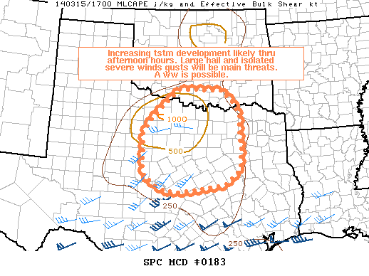
ACCOMPANIES THEM. THE GREATEST CHANCE OF SEVERE WEATHER WILL BE
THIS AFTERNOON AND EVENING SOUTH OF THE I-20. SOME SUPERCELLS ARE
POSSIBLE. THUS WE WILL SEE A CHANCE OF LARGE HAIL AND DAMAGING
WINDS AND CAN NOT RULE OUT A FEW TORNADOES ESPECIALLY ACROSS THE
SOUTHERN PART OF THE FORECAST AREA LATE AFTERNOON/EARLY EVENING.

RAIN CHANCES WILL CONTINUE OVERNIGHT INTO SUNDAY. THE
AFOREMENTIONED SECOND SHORTWAVE IS FORECAST TO DIVE SOUTHEAST
INTO NEW MEXICO TONIGHT AND THEN EAST INTO TEXAS SUNDAY
AFTERNOON. THERE ARE SIGNIFICANT MODEL DIFFERENCES IN THE MODEL
FORECASTS FOR THIS SYSTEM. THE NAM IS THE COLDEST AND WETTEST
MODEL. IT GENERATES SNOW ACROSS THE WESTERN HALF OF THE FORECAST
AREA SUNDAY AFTERNOON INTO SUNDAY NIGHT...WITH STORM TOTAL
SNOWFALL OF 1 INCH OR MORE ALONG AND WEST OF A LINE FROM 10 MILES
NORTH OF BRECKENRIDGE TO 10 MILES SOUTHWEST OF DECATUR TO JUST
WEST OF WAXAHACHIE TO TEMPLE. AMAZINGLY IT HAS A 3 INCH PLUS SNOW
ISOPLETH FROM CISCO TO WEATHERFORD TO CLIFTON TO LAMPASAS WITH A
6 INCH BULLS EYE OVER ERATH AND NORTHERN HAMILTON COUNTIES. NONE
OF THE OTHER OPERATIONAL MODELS ARE INDICATING ANYTHING LIKE THE
NAM AS FAR AS WINTRY PRECIPITATION IS CONCERNED. THE 15/03Z SREF
PLUMES DID SHOW A FEW MEMBERS OTHER THAN THE NAM WITH GREATER
THAN 1 INCH SNOWFALL ACROSS THE WESTERN COUNTIES. AT THIS
TIME...BELIEVE THAT IT IS PRUDENT TO ADD A MENTION OF RAIN/SNOW
ACROSS THE WESTERN ZONES FOR SUNDAY AFTERNOON. EVEN IF IT DOES
SNOW...ACCUMULATIONS SHOULD BE PRIMARILY ON ELEVATED SURFACES AND
GRASS. WE WILL HAVE TO MONITOR THIS SYSTEM CLOSELY AS WITH VERY
COLD AIR ALOFT ASSOCIATED AN A POSSIBLY CLOSED UPPER LEVEL
LOW...WE COULD END UP WITH GREATER ACCUMULATIONS THAN WE ARE
CURRENTLY FORECASTING FOR SUNDAY AFTERNOON AND SUNDAY NIGHT.

A FREEZE IS POSSIBLE MAINLY ACROSS THE WESTERN AND NORTHERN PARTS
OF THE FORECAST AREA MONDAY MORNING. DRY WEATHER IS EXPECTED FOR
THE UPCOMING WORK WEEK. WE WILL SEE TEMPERATURES WARM UP MONDAY
AND TUESDAY BEFORE ANOTHER COLD FRONT MOVES THROUGH TUESDAY
NIGHT. SOUTHERLY WINDS WILL RETURN BY THURSDAY WITH ANOTHER WARM
UP EXPECTED. RAIN CHANCES WILL RETURN FRIDAY NIGHT AND SATURDAY
AS ANOTHER SHORTWAVE MOVES ACROSS THE REGION.


maybe they are wishcasting too. :wink:
0 likes   
The above post and any post by dhweather is NOT an official forecast and should not be used as such. It is just the opinion of the poster and may or may not be backed by sound meteorological data. It is NOT endorsed by any professional institution including storm2k.org. For official information, please refer to NWS products.

Ntxw
Storm2k Moderator
Storm2k Moderator
Posts: 21500
Joined: Wed Oct 21, 2009 6:34 pm
Location: DFW, Texas

#9936 Postby Ntxw » Sat Mar 15, 2014 9:46 am

It is a small possibility, not a likely one but not impossible. Things must line up perfectly and even then a localized event. Still would like to see the low cut off and rapidly intensify. The bigger story is rain, most of us who have received less than an inch SHOULD (never a guaranty) double.

Long range does not bode well for spring. As in a post before North America will be under the influence of a cold air mass. Models underperform with low level cold involving PV near Hudson bay and our profound -EPO ridge.
0 likes   
The above post and any post by Ntxw is NOT an official forecast and should not be used as such. It is just the opinion of the poster and may or may not be backed by sound meteorological data. It is NOT endorsed by any professional institution including Storm2k. For official information, please refer to NWS products.


  Help support Storm2K!

Help Support Storm2K


User avatar
Portastorm
Storm2k Moderator
Storm2k Moderator
Posts: 9787
Age: 61
Joined: Fri Jul 11, 2003 9:16 am
Location: South Austin, TX
Contact:

Re:

#9937 Postby Portastorm » Sat Mar 15, 2014 9:48 am

Ntxw wrote:It is a small possibility, not a likely one but not impossible. Things must line up perfectly and even then a localized event. Still would like to see the low cut off and rapidly intensify. The bigger story is rain, most of us who have received less than an inch SHOULD (never a guaranty) double.

Long range does not bode well for spring. As in a post before North America will be under the influence of a cold air mass. Models underperform with low level cold involving PV near Hudson bay and our profound -EPO ridge.


Yeah, the 12z NAM really backs off compared to what it showed in the 0z run ... in terms of snowfall potential. The SREF does suggest something "wintry" tomorrow evening for portions of northeast Texas but, channeling my inner wxman57 here, these models seem to be the outliers compared to the GFS and Euro.

Good luck to us all on the rainfall potential!
0 likes   
Any forecasts under my name are to be taken with a grain of salt. Get your best forecasts from the National Weather Service and National Hurricane Center.

I'm a certified Advanced SKYWARN-trained spotter and am active on Twitter at @TravisCOSW, a social media partner of the NWS Austin-San Antonio office.

User avatar
Texas Snowman
Storm2k Moderator
Storm2k Moderator
Posts: 6011
Joined: Fri Jan 25, 2008 11:29 am
Location: Denison, Texas

#9938 Postby Texas Snowman » Sat Mar 15, 2014 11:51 am

If it DID happen in NE Texas, Wxman 57 might have to go into hiding after his wish casting post yesterday! :D
0 likes   
The above post and any post by Texas Snowman is NOT an official forecast and should not be used as such. It is just the opinion of the poster and may or may not be backed by sound meteorological data. It is NOT endorsed by any professional institution including storm2k.org. For official information, please refer to NWS products.

BrokenGlassRepublicn
Category 1
Category 1
Posts: 479
Joined: Sun Nov 20, 2011 8:07 pm
Location: Richardson, Texas

Re: Texas Winter 2013-2014

#9939 Postby BrokenGlassRepublicn » Sat Mar 15, 2014 1:30 pm

I just went to get my mail and there was something falling from the sky. Little water droplets of some kind. Can anyone tell me what that is?
0 likes   

User avatar
dhweather
S2K Supporter
S2K Supporter
Posts: 6163
Joined: Sat Aug 14, 2004 9:29 pm
Location: Heath, TX
Contact:

Re: Texas Winter 2013-2014

#9940 Postby dhweather » Sat Mar 15, 2014 1:39 pm

Image

MESOSCALE DISCUSSION 0183
NWS STORM PREDICTION CENTER NORMAN OK
0113 PM CDT SAT MAR 15 2014

AREAS AFFECTED...PORTIONS OF CENTRAL/N TX...EXTREME SRN OK

CONCERNING...SEVERE POTENTIAL...WATCH POSSIBLE

VALID 151813Z - 152015Z

PROBABILITY OF WATCH ISSUANCE...60 PERCENT

SUMMARY...TSTMS ARE EXPECTED TO INCREASE IN COVERAGE AND INTENSITY
THROUGH REMAINDER OF AFTN. SCTD SVR TSTMS ARE EXPECTED WITH LARGE
HAIL AND A FEW SVR WIND GUSTS...AND A TORNADO CANNOT BE RULED OUT. A
WW IS POSSIBLE PRIOR TO 20Z.

DISCUSSION...LATEST MESOANALYSIS INDICATES A BROAD/DIFFUSE AREA OF
LOW PRESSURE ACROSS W TX WITH MODEST SE/SLY LOW-LEVEL FLOW
CONTRIBUTING TO MOISTENING/GRADUAL DESTABILIZATION ACROSS DISCUSSION
AREA. TSTMS HAVE BEEN INCREASING IN AREAL COVERAGE OVER THE PAST TWO
HOURS AS LARGER-SCALE FORCING FOR ASCENT OVERSPREADS WRN PORTIONS OF
N TX. WIDESPREAD CLOUD COVER/PRECIP WILL LIMIT OVERALL
DESTABILIZATION SOMEWHAT...HOWEVER EXPECT A CORRIDOR OF MLCAPES OF
1000 - 1250 J/KG TO DEVELOP BY MID-LATE AFTN AS COLD ADVECTION ALOFT
COMBINES WITH BREAKS IN CLOUD COVER/LOCALLY GREATER HEATING.

LOW-MID LEVEL WIND FIELDS WILL STRENGTHEN SLIGHTLY AS THE UPPER
LEVEL IMPULSE APPROACHES CENTRAL/NRN TX AND SRN OK...WITH DEEP-LAYER
SHEAR SUFFICIENT FOR SUPERCELLS. THE LATEST VAD WIND PROFILE FROM
KFWS REFLECTS A STRAIGHT-LINE HODOGRAPH SUPPORTIVE OF THE POTENTIAL
FOR SPLITTING STORMS. LARGE HAIL WILL BE THE MOST LIKELY THREAT WITH
DAMAGING GUSTS ALSO POSSIBLE...ESPECIALLY WHERE HEATING/STEEPER
LOW-LEVEL LAPSE RATES EXIST. AN ISOLATED TORNADO CANNOT BE RULED
OUT...BUT LOW LEVEL WINDS/SRH ARE NOT PARTICULARLY STRONG...LIMITING
THE OVERALL THREAT.

CONVECTIVE TRENDS WILL CONTINUE TO BE MONITORED AND A WW IS POSSIBLE
BY 20Z.

..BUNTING/CORFIDI.. 03/15/2014
0 likes   
The above post and any post by dhweather is NOT an official forecast and should not be used as such. It is just the opinion of the poster and may or may not be backed by sound meteorological data. It is NOT endorsed by any professional institution including storm2k.org. For official information, please refer to NWS products.


Return to “Winter Weather”

Who is online

Users browsing this forum: No registered users and 89 guests