Texas Winter 2013-2014

Winter Weather Discussion

Moderator: S2k Moderators

Forum rules

The posts in this forum are NOT official forecast and should not be used as such. They are just the opinion of the poster and may or may not be backed by sound meteorological data. They are NOT endorsed by any professional institution or STORM2K.

Help Support Storm2K
Message
Author
User avatar
Portastorm
Storm2k Moderator
Storm2k Moderator
Posts: 9787
Age: 61
Joined: Fri Jul 11, 2003 9:16 am
Location: South Austin, TX
Contact:

Re: Texas Winter 2013-2014

#221 Postby Portastorm » Tue Nov 05, 2013 3:38 pm

Here is what the winter of 1981-82 looked like in terms of overall precip and temp averages.

Image

Uploaded with ImageShack.us


Image

Uploaded with ImageShack.us
0 likes   
Any forecasts under my name are to be taken with a grain of salt. Get your best forecasts from the National Weather Service and National Hurricane Center.

I'm a certified Advanced SKYWARN-trained spotter and am active on Twitter at @TravisCOSW, a social media partner of the NWS Austin-San Antonio office.

natlib
Tropical Storm
Tropical Storm
Posts: 159
Joined: Tue Dec 01, 2009 10:09 am
Location: San Angelo, TX

Re: Texas Winter 2013-2014

#222 Postby natlib » Tue Nov 05, 2013 6:06 pm

Portastorm wrote:Here is what the winter of 1981-82 looked like in terms of overall precip and temp averages.

http://img43.imageshack.us/img43/400/5n5i.png

Uploaded with ImageShack.us


http://img707.imageshack.us/img707/9779/pgxs.png

Uploaded with ImageShack.us


I guess the fact that there are no shades of orange of red should be considered a good thing right!????
0 likes   

User avatar
gboudx
S2K Supporter
S2K Supporter
Posts: 4047
Joined: Thu Sep 04, 2003 1:39 pm
Location: Rockwall, Tx but from Harvey, La

Re: Texas Winter 2013-2014

#223 Postby gboudx » Tue Nov 05, 2013 6:09 pm

natlib wrote:I guess the fact that there are no shades of orange of red should be considered a good thing right!????


For the bottom pic, yes. Unless your S2k handle is "wxman57".
0 likes   

User avatar
wxman57
Moderator-Pro Met
Moderator-Pro Met
Posts: 22480
Age: 66
Joined: Sat Jun 21, 2003 8:06 pm
Location: Houston, TX (southwest)

Re: Texas Winter 2013-2014

#224 Postby wxman57 » Tue Nov 05, 2013 6:42 pm

Yeah, "good thing" is relative. It means 81-82 was fairly "normal" on average, with a short cold period in January. Of course, I'm not sure 81-82 is a good analog.
0 likes   

natlib
Tropical Storm
Tropical Storm
Posts: 159
Joined: Tue Dec 01, 2009 10:09 am
Location: San Angelo, TX

Re: Texas Winter 2013-2014

#225 Postby natlib » Wed Nov 06, 2013 9:08 am

Steve McCauley....former weather man at WFAA in Dallas had this to say this morning on his facebook page.....

Very encouraging for us winter weather lovers....

And for those of you who have been asking about the upcoming winter season, I have some encouraging news in the ultra long-range forecast for those of you who enjoy Texas snowfall. There are indications in both the European and Japanese models that conditions will be setting up in the Pacific and the North Atlantic such that there will be an increased tendency for very cold air to drain into the United States on a more frequent basis than normal, especially by late January into most of February.

At the same time, an active subtropical jet flowing over these cold air outbreaks should be able to increase our winter precipitation to above normal, especially as we get past mid January. Therefore, the data suggest - although do not guarantee, obviously - that we should see above normal snowfall across north Texas (and indeed much of the country) this winter!

Perhaps the Farmer's Almanac was on to something ?!? We shall see.
0 likes   

User avatar
Big O
Category 1
Category 1
Posts: 252
Age: 53
Joined: Sun Sep 16, 2007 4:40 pm
Location: McAllen, Texas

Re: Texas Winter 2013-2014

#226 Postby Big O » Wed Nov 06, 2013 9:43 am

wxman57 wrote:
natlib wrote:Larry Cosgrove is using 1981-82 as a possible analog for this winter. Anyone have any data on that winter to share?


Was checking Houston record highs/lows for Dec-Feb and I have good news and bad news. The good news was the record high of 81 on Dec. 22, 1981. Bad news is the low of 12 on Jan 11, 1982 and 19 degrees a couple of days later. Those were the only records I saw. It was my second winter in Houston and I don't remember much about it. I remember the winter of 1983-84 quite well, though...


Wxman, are you alluding to the fact that you or your long-range winter weather expert is thinking of 1983-84 as an analog for this winter?
0 likes   

User avatar
gboudx
S2K Supporter
S2K Supporter
Posts: 4047
Joined: Thu Sep 04, 2003 1:39 pm
Location: Rockwall, Tx but from Harvey, La

Re: Texas Winter 2013-2014

#227 Postby gboudx » Wed Nov 06, 2013 10:14 am

natlib wrote:Steve McCauley....former weather man at WFAA in Dallas had this to say this morning on his facebook page.....

Very encouraging for us winter weather lovers....

And for those of you who have been asking about the upcoming winter season, I have some encouraging news in the ultra long-range forecast for those of you who enjoy Texas snowfall. There are indications in both the European and Japanese models that conditions will be setting up in the Pacific and the North Atlantic such that there will be an increased tendency for very cold air to drain into the United States on a more frequent basis than normal, especially by late January into most of February.

At the same time, an active subtropical jet flowing over these cold air outbreaks should be able to increase our winter precipitation to above normal, especially as we get past mid January. Therefore, the data suggest - although do not guarantee, obviously - that we should see above normal snowfall across north Texas (and indeed much of the country) this winter!

Perhaps the Farmer's Almanac was on to something ?!? We shall see.


Where is Steve now? I don't watch local news much but I have noticed a guy named Ashton on and not Steve. I also haven't seen the blonde hottie either.
0 likes   

gpsnowman
S2K Supporter
S2K Supporter
Posts: 2711
Joined: Fri Jan 07, 2011 10:35 am
Location: Grand Prairie Tx

#228 Postby gpsnowman » Wed Nov 06, 2013 10:41 am

:uarrow: He left WFAA sometime in late summer to concentrate on his teaching and studies. He still gives almost daily weather updates on his facebook page. He has a large following online. Very smart and informative weatherman. You should check it out.
0 likes   

User avatar
gboudx
S2K Supporter
S2K Supporter
Posts: 4047
Joined: Thu Sep 04, 2003 1:39 pm
Location: Rockwall, Tx but from Harvey, La

#229 Postby gboudx » Wed Nov 06, 2013 11:00 am

:uarrow: That proves I don't watch local news much if he left late Summer and I didn't notice. :cheesy:

I don't have a FB account and don't really want one. But, if he's on Twitter I'll try and catch him there. Thanks.
0 likes   

Ntxw
Storm2k Moderator
Storm2k Moderator
Posts: 21495
Joined: Wed Oct 21, 2009 6:34 pm
Location: DFW, Texas

Re: Texas Winter 2013-2014

#230 Postby Ntxw » Wed Nov 06, 2013 11:14 am

natlib wrote:And for those of you who have been asking about the upcoming winter season, I have some encouraging news in the ultra long-range forecast for those of you who enjoy Texas snowfall. There are indications in both the European and Japanese models that conditions will be setting up in the Pacific and the North Atlantic such that there will be an increased tendency for very cold air to drain into the United States on a more frequent basis than normal, especially by late January into most of February.


This

Image

And this

Image

Keep your eyes on the northeast Pacific. EPO EPO EPO...I like the January idea. Think early 1960s.
0 likes   
The above post and any post by Ntxw is NOT an official forecast and should not be used as such. It is just the opinion of the poster and may or may not be backed by sound meteorological data. It is NOT endorsed by any professional institution including Storm2k. For official information, please refer to NWS products.

  Help support Storm2K!
Help Support Storm2K

User avatar
Texas Snowman
Storm2k Moderator
Storm2k Moderator
Posts: 6011
Joined: Fri Jan 25, 2008 11:29 am
Location: Denison, Texas

Re: Texas Winter 2013-2014

#231 Postby Texas Snowman » Wed Nov 06, 2013 1:33 pm

Well, well, well.

Look at what the GFS delivered for next week.

Do I see snow on the ground in Oklahoma? May or may not happen, but can the Heat Miser's demise be far behind?!?

Image
0 likes   
The above post and any post by Texas Snowman is NOT an official forecast and should not be used as such. It is just the opinion of the poster and may or may not be backed by sound meteorological data. It is NOT endorsed by any professional institution including storm2k.org. For official information, please refer to NWS products.

User avatar
CaptinCrunch
S2K Supporter
S2K Supporter
Posts: 8566
Age: 56
Joined: Mon Nov 03, 2003 4:33 pm
Location: Lake Worth, TX (Tarrant Co.)

Re: Texas Winter 2013-2014

#232 Postby CaptinCrunch » Wed Nov 06, 2013 4:00 pm

URGENT - WEATHER MESSAGE
NATIONAL WEATHER SERVICE FORT WORTH TX
208 PM CST WED NOV 6 2013


...A FROST ADVISORY IS IN EFFECT THURSDAY FROM 3 AM TO 9 AM
FOR AREAS ALONG AND NORTHWEST OF A LINE FROM COPPERAS COVE TO
FORT WORTH TO MCKINNEY TO SULPHUR SPRINGS...

.AREAS OF FROST ARE EXPECTED TO DEVELOP LATE TONIGHT ACROSS THE
WESTERN AND NORTHERN PARTS OF NORTH TEXAS AS TEMPERATURES FALL
INTO THE LOW TO MID 30S WITH LIGHT WINDS.

TXZ091>095-100>107-115>118-129>132-141>144-156-157-070415-
/O.NEW.KFWD.FR.Y.0001.131107T0900Z-131107T1500Z/
MONTAGUE-COOKE-GRAYSON-FANNIN-LAMAR-YOUNG-JACK-WISE-DENTON-COLLIN-
HUNT-DELTA-HOPKINS-STEPHENS-PALO PINTO-PARKER-TARRANT-EASTLAND-
ERATH-HOOD-SOMERVELL-COMANCHE-MILLS-HAMILTON-BOSQUE-LAMPASAS-
CORYELL-
INCLUDING THE CITIES OF...BOWIE...NOCONA...GAINESVILLE...
SHERMAN...DENISON...BONHAM...PARIS...GRAHAM...OLNEY...JACKSBORO...
DECATUR...BRIDGEPORT...DENTON...LEWISVILLE...FLOWER MOUND...
THE COLONY...PLANO...GREENVILLE...COMMERCE...COOPER...
SULPHUR SPRINGS...BRECKENRIDGE...MINERAL WELLS...WEATHERFORD...
BRIAR...FORT WORTH...ARLINGTON...CISCO...EASTLAND...RANGER...
GORMAN...STEPHENVILLE...DUBLIN...GRANBURY...OAK TRAIL SHORES...
GLEN ROSE...COMANCHE...DE LEON...GOLDTHWAITE...HAMILTON...HICO...
CLIFTON...MERIDIAN...VALLEY MILLS...LAMPASAS...COPPERAS COVE...
GATESVILLE
208 PM CST WED NOV 6 2013

...FROST ADVISORY IN EFFECT FROM 3 AM TO 9 AM CST THURSDAY...
THE NATIONAL WEATHER SERVICE IN FORT WORTH HAS ISSUED A FROST
ADVISORY...WHICH IS IN EFFECT FROM 3 AM TO 9 AM CST THURSDAY.

* TEMPERATURE...TEMPERATURES BETWEEN 33 AND 36 DEGREES WILL BE
COMMON AT EYE LEVEL.

* IMPACTS...SENSITIVE PLANTS MAY BE DAMAGED OR KILLED BY FROST AND
NEAR FREEZING TEMPERATURES.


PRECAUTIONARY/PREPAREDNESS ACTIONS...

A FROST ADVISORY MEANS THAT FROST IS POSSIBLE. SENSITIVE OUTDOOR
PLANTS MAY BE KILLED IF LEFT UNCOVERED. COVER OR BRING IN YOUR
SENSITIVE PLANTS TO PROTECT THEM.
0 likes   

User avatar
Rgv20
S2K Supporter
S2K Supporter
Posts: 2456
Age: 37
Joined: Wed Jan 05, 2011 5:42 pm
Location: Edinburg/McAllen Tx

#233 Postby Rgv20 » Thu Nov 07, 2013 2:28 am

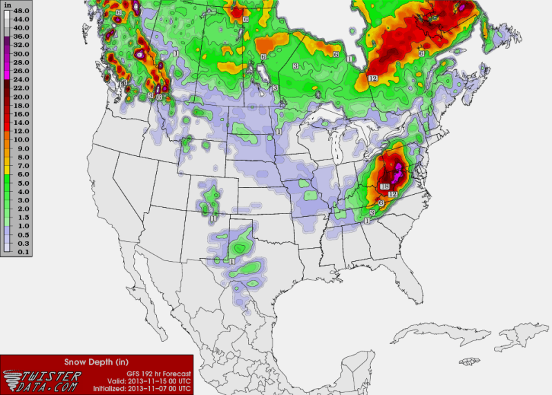
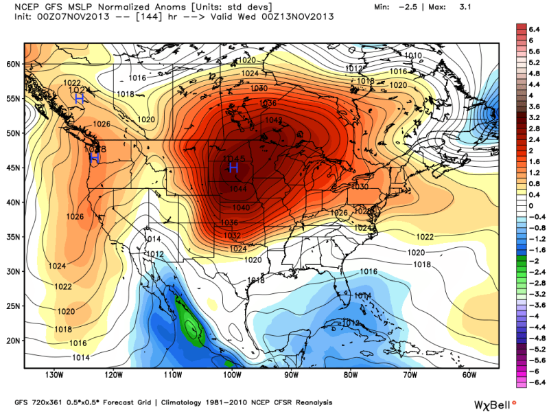
Looks to me like the 0z runs of the GFS and ECMWF are hinting at some cold weather coming to Texas by the end of next week. 0zECMWF has a major winter storm for Oklahoma with snow as far south into Dallas by next Friday!

0zGFS snow forecast for next Thursday November 14..
Image

0zGFS Sea level pressure forecast courtesy of Ryan Maue Twitter....1046MB High in 6 days!
Image
0 likes   
The following post is NOT an official forecast and should not be used as such. It is just the opinion of the poster and may or may not be backed by sound meteorological data. It is NOT endorsed by any professional institution including storm2k.org For Official Information please refer to the NHC and NWS products.

User avatar
CaptinCrunch
S2K Supporter
S2K Supporter
Posts: 8566
Age: 56
Joined: Mon Nov 03, 2003 4:33 pm
Location: Lake Worth, TX (Tarrant Co.)

Re: Texas Winter 2013-2014

#234 Postby CaptinCrunch » Thu Nov 07, 2013 9:16 am

AREA FORECAST DISCUSSION
NATIONAL WEATHER SERVICE FORT WORTH TX
532 AM CST THU NOV 7 2013


OUR NEXT CHALLENGE COMES AT MID WEEK. BOTH THE ECMWF AND GFS ARE
IN GOOD AGREEMENT THROUGH TUESDAY. THE DIFFERENCES BEGIN TO SHOW
ON TUESDAY NIGHT AS THE GFS BRINGS A STRONGER SHORTWAVE THROUGH
THE PACIFIC NORTHWEST AND THEN AMPLIFIES IT OVER THE ROCKIES WITH
UPPER RIDGING DEVELOPING ALONG THE WEST COAST. THE ECMWF ALSO
SHOWS THIS SHORTWAVE BUT IT IS ABOUT 12-18 HOURS SLOWER AND
DEVELOPS A CLOSED LOW OVER THE COLORADO FRONT RANGE BY FRIDAY. THE
RESULT OF THE GFS WOULD SPREAD COLD CANADIAN AIR SOUTHWARD INTO
THE REGION BEHIND A COLD FRONT TUESDAY NIGHT WHILE THE ECMWF
DELAYS THE ARRIVAL OF THE COLD AIR/FRONT UNTIL MIDDAY WEDNESDAY.
FOR NOW...WE/VE SIDED WITH THE ECMWF TIMING...BUT THIS WILL LIKELY
CHANGE AS WE GET CLOSER TO THE EVENT. EITHER WAY.....IT WILL BE
TURNING NOTICEABLY COLDER BEHIND THIS FRONT...AND HAVE ADJUSTED
LOWS/HIGHS DOWNWARD SEVERAL CATEGORIES BELOW THE MOS GUIDANCE
NUMBERS. HOWEVER...IF THE AIRMASS OF THE GFS PANS OUT...THEN OUR
CURRENT FORECAST TEMPERATURES WEDNESDAY THROUGH FRIDAY MORNING ARE
TOO WARM. 75


Looks like I need to start getting the fireplace ready and wood pile stocked back up. :cold:
0 likes   

User avatar
Rgv20
S2K Supporter
S2K Supporter
Posts: 2456
Age: 37
Joined: Wed Jan 05, 2011 5:42 pm
Location: Edinburg/McAllen Tx

#235 Postby Rgv20 » Thu Nov 07, 2013 11:09 am

This is the morning discussion out of the NWS in Corpus Christi.....The 0z Operational ECMWF is basically in the colder extreme in temperatures compare to its ensembles for North Texas, going to be interesting what the 12z run of the ECMWF and GFS show!

BUT OVERALL NO SIGNIFICANT RAINFALL IS CURRENTLY FORECAST
FOR EARLY NEXT WEEK. MODEL DISCREPANCIES INCREASE SIGNIFICANTLY BY
THE MIDDLE OF NEXT WEEK WITH 00Z GFS BRINGING STRONG 1045MB HIGH
SOUTH OUT OF CANADA AND BLASTING AN ARCTIC COLD FRONT ACROSS THE
CWA. ECMWF IS SLOWER WITH SYSTEM WITH COLDEST AIRMASS STAYING TO OUR
NORTH WHILE GEFS PERTURBATIONS ARE WIDELY SCATTERED. FOR NOW WILL
LEAN TOWARDS ECMWF BUT TIMING MAY NEED TO BE SPED UP IN FUTURE
FORECAST PACKAGES IF MORE POTENT SHALLOW ARCTIC AIRMASS BECOMES
EVIDENT. TEMPS WILL GRADUALLY WARM TO NEAR SEASONABLE LEVELS OVER
THE WEEKEND AND INTO EARLY NEXT WEEK...AND THEN BECOME DEPENDENT ON
POSSIBLE FROPA BY END OF FORECAST PERIOD. THANKS TO BRO AND EWX FOR
COORDINATION.
0 likes   
The following post is NOT an official forecast and should not be used as such. It is just the opinion of the poster and may or may not be backed by sound meteorological data. It is NOT endorsed by any professional institution including storm2k.org For Official Information please refer to the NHC and NWS products.

User avatar
Texas Snowman
Storm2k Moderator
Storm2k Moderator
Posts: 6011
Joined: Fri Jan 25, 2008 11:29 am
Location: Denison, Texas

#236 Postby Texas Snowman » Fri Nov 08, 2013 7:00 am

From Fort Worth this morning:

"THE ECMWF IS NOW IN BETTER AGREEMENT WITH THE GFS CONCERNING OUR
NEXT COLD FRONT. BOTH NOW AGREE ON TUESDAY AND THAT THE AIRMASS
WILL ORIGINATE FROM NORTHWEST CANADA. TEMPERATURES IN THIS REGION
ARE RUNNING IN THE TEENS AND 20S WITH SURFACE PRESSURES AROUND
1028 MB. THE TRAJECTORY OF THE HIGH PRESSURE CENTER WILL TAKE IT
ACROSS THE NORTHERN PLAINS AND INTO THE MID-SOUTH REGION BY MIDDAY
WEDNESDAY. FOR THIS FORECAST...THE FRONT TIMING WILL BE: CROSSING
THE RED RIVER EARLY TUESDAY MORNING...THROUGH DFW BEFORE MIDDAY
AND THROUGH WACO...KILLEEN AND TEMPLE EARLY AFTERNOON. GUSTY NORTH
WINDS AND MUCH COLDER TEMPERATURES WILL FOLLOW.

WE/VE CONTINUED OUR TREND OF KEEPING TEMPERATURES BEHIND THE COLD
FRONT 5 TO 10 DEGREES BELOW CURRENT MOS GUIDANCE...BUT THIS MAY
NOT BE ENOUGH IF WE TRULY RECEIVE A DIRECT BLOW OF THIS ARCTIC
AIRMASS. FOR NOW SETTLED ON LOWS IN THE UPPER 20S TO MID 30S ON
THURSDAY MORNING AND HIGHS IN THE 50S WEDNESDAY AND THURSDAY.
FRIDAY WILL BE SLIGHTLY WARMER. ALTHOUGH A COUPLE SITES IN THE
NORTHWEST PORTION HAVE REACHING FREEZING THIS SEASON...THIS EVENT
COULD PRODUCE OUR FIRST WIDESPREAD FREEZE. 75"
0 likes   
The above post and any post by Texas Snowman is NOT an official forecast and should not be used as such. It is just the opinion of the poster and may or may not be backed by sound meteorological data. It is NOT endorsed by any professional institution including storm2k.org. For official information, please refer to NWS products.

User avatar
lrak
S2K Supporter
S2K Supporter
Posts: 1770
Age: 57
Joined: Thu Jun 21, 2007 2:48 pm
Location: Corpus Christi, TX

Re: Texas Winter 2013-2014

#237 Postby lrak » Fri Nov 08, 2013 3:07 pm

The Weather Channel 10 day forecast has November 16th and 17th near 80 degrees for the highs in CC TX? IYO will it warm up that quick from the cold weather you all are forecasting? Or is the front going to stall and not make it this far South? I don't understand the CC weather discussion regarding next week :(
Thanks! :flag:
0 likes   
AKA karl

Also
Personal Forecast Disclaimer:
My posts on this forum are NOT official forecast and should not be used as such. My posts are my basic observations and are definitely not backed by any "well some" meteorological knowledge. For official information, please refer to the NHC and NWS products.

User avatar
wxman57
Moderator-Pro Met
Moderator-Pro Met
Posts: 22480
Age: 66
Joined: Sat Jun 21, 2003 8:06 pm
Location: Houston, TX (southwest)

Re: Texas Winter 2013-2014

#238 Postby wxman57 » Fri Nov 08, 2013 3:47 pm

Big O wrote:
Wxman, are you alluding to the fact that you or your long-range winter weather expert is thinking of 1983-84 as an analog for this winter?


Definitely not. I'm just saying that the winter of '81-'82 wasn't memorable for me but '83-'84 sure was.
0 likes   

User avatar
wxman57
Moderator-Pro Met
Moderator-Pro Met
Posts: 22480
Age: 66
Joined: Sat Jun 21, 2003 8:06 pm
Location: Houston, TX (southwest)

Re: Texas Winter 2013-2014

#239 Postby wxman57 » Fri Nov 08, 2013 3:48 pm

lrak wrote:The Weather Channel 10 day forecast has November 16th and 17th near 80 degrees for the highs in CC TX? IYO will it warm up that quick from the cold weather you all are forecasting? Or is the front going to stall and not make it this far South? I don't understand the CC weather discussion regarding next week :(
Thanks! :flag:


I was in Corpus Christi Mon/Tue visiting clients. Was nice and warm. With the Gulf still so very warm, all it takes is a wind out of the SE to get your temps back up to 80 degrees this time of year.
0 likes   

User avatar
lrak
S2K Supporter
S2K Supporter
Posts: 1770
Age: 57
Joined: Thu Jun 21, 2007 2:48 pm
Location: Corpus Christi, TX

Re: Texas Winter 2013-2014

#240 Postby lrak » Fri Nov 08, 2013 4:14 pm

Ah Man I feel dumb, I should of figured that out myself. Thanks wxman57 you always help me out.

I'm just glad its not going to be :cold: like North TX is going to be, again thank you for your reply.

Let me know if you ever want to go fishing or go out to eat when you come down next time :D
0 likes   
AKA karl

Also
Personal Forecast Disclaimer:
My posts on this forum are NOT official forecast and should not be used as such. My posts are my basic observations and are definitely not backed by any "well some" meteorological knowledge. For official information, please refer to the NHC and NWS products.


Return to “Winter Weather”

Who is online

Users browsing this forum: No registered users and 142 guests