Ohio Valley and Eastern KY Winter 2013-2014
Moderator: S2k Moderators
Forum rules
 The posts in this forum are NOT official forecast and should not be used as such. They are just the opinion of the poster and may or may not be backed by sound meteorological data. They are NOT endorsed by any professional institution or STORM2K.

The posts in this forum are NOT official forecast and should not be used as such. They are just the opinion of the poster and may or may not be backed by sound meteorological data. They are NOT endorsed by any professional institution or STORM2K.
-
WeatherGuesser
- Category 5

- Posts: 2672
- Joined: Tue Jun 29, 2010 6:46 am
-
tolakram
- Admin

- Posts: 19165
- Age: 60
- Joined: Sun Aug 27, 2006 8:23 pm
- Location: Florence, KY (name is Mark)
Re: Ohio Valley and Eastern KY Winter 2013-2014
Our low appears to have been -7 early last night. Record for today was -9 back in 1912 but the record for yesterday was -7 set in 1924 so we tied it.
Our all time record low was the winter of 76/77, January 18th -25F. Runner up is the next day but in 1994, -24F. After that it's a couple of -21F readings from 1984.
So this was a cold air mass, but nothing super spectacular for us. It's about time we had a cold winter, that's for sure.
Our all time record low was the winter of 76/77, January 18th -25F. Runner up is the next day but in 1994, -24F. After that it's a couple of -21F readings from 1984.
So this was a cold air mass, but nothing super spectacular for us. It's about time we had a cold winter, that's for sure.
0 likes
M a r k
- - - - -
Join us in chat: Storm2K Chatroom Invite. Android and IOS apps also available.
The posts in this forum are NOT official forecasts and should not be used as such. Posts are NOT endorsed by any professional institution or STORM2K.org. For official information and forecasts, please refer to NHC and NWS products.
-
WeatherGuesser
- Category 5
- Posts: 2672
- Joined: Tue Jun 29, 2010 6:46 am
Glancing at our records, the low temp records for last few days were in the -5 range. Some were tied, some broken, but none really shattered.
Of more concern is the range of records for the 16th to 21st when records are in the -15 range and the guys on the Texas thread are talking about another cold surge that week.
Of more concern is the range of records for the 16th to 21st when records are in the -15 range and the guys on the Texas thread are talking about another cold surge that week.
0 likes
-
WeatherGuesser
- Category 5
- Posts: 2672
- Joined: Tue Jun 29, 2010 6:46 am
-
WeatherGuesser
- Category 5
- Posts: 2672
- Joined: Tue Jun 29, 2010 6:46 am
-
WeatherGuesser
- Category 5
- Posts: 2672
- Joined: Tue Jun 29, 2010 6:46 am
Washington Post discussion for the northeast. Colder than normal for a longer period of time, but not AS cold at the last round. No extreme temps:
http://www.washingtonpost.com/blogs/cap ... _local_pop
http://www.washingtonpost.com/blogs/cap ... _local_pop
0 likes
-
brunota2003

- S2K Supporter

- Posts: 9476
- Age: 33
- Joined: Sat Jul 30, 2005 9:56 pm
- Location: Stanton, KY...formerly Havelock, NC
- Contact:
I've seen GFS images in the last couple days showing temps as low as -17F all the way into central KY. While this is still 9 days or so out (27th through 30th were the images posted), the main thing I've been told that stood out was the length the cold was around...much longer than last time, where it was around for only 3 or so days.
0 likes
Just a small town southern boy helping other humans.
-
brunota2003
- S2K Supporter
- Posts: 9476
- Age: 33
- Joined: Sat Jul 30, 2005 9:56 pm
- Location: Stanton, KY...formerly Havelock, NC
- Contact:
Re: Ohio Valley and Eastern KY Winter 2013-2014
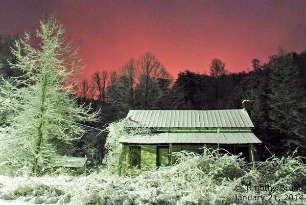
It snowed today! I took that image at 6:50 am, we had roughly 1.2 inches of snow on the ground at the time. Storm total, as of 6:50 pm, was 5.7 inches!
0 likes
Just a small town southern boy helping other humans.
-
tolakram
- Admin
- Posts: 19165
- Age: 60
- Joined: Sun Aug 27, 2006 8:23 pm
- Location: Florence, KY (name is Mark)
Re: Ohio Valley and Eastern KY Winter 2013-2014
Nice pic!
We have around 5 inches. You would think I lived in the deep south based on the reaction to the cold and snow around here.
We have around 5 inches. You would think I lived in the deep south based on the reaction to the cold and snow around here.
0 likes
M a r k
- - - - -
Join us in chat: Storm2K Chatroom Invite. Android and IOS apps also available.
The posts in this forum are NOT official forecasts and should not be used as such. Posts are NOT endorsed by any professional institution or STORM2K.org. For official information and forecasts, please refer to NHC and NWS products.
- - - - -
Join us in chat: Storm2K Chatroom Invite. Android and IOS apps also available.
The posts in this forum are NOT official forecasts and should not be used as such. Posts are NOT endorsed by any professional institution or STORM2K.org. For official information and forecasts, please refer to NHC and NWS products.
-
WeatherGuesser
- Category 5
- Posts: 2672
- Joined: Tue Jun 29, 2010 6:46 am
-
brunota2003
- S2K Supporter
- Posts: 9476
- Age: 33
- Joined: Sat Jul 30, 2005 9:56 pm
- Location: Stanton, KY...formerly Havelock, NC
- Contact:
-
WeatherGuesser
- Category 5
- Posts: 2672
- Joined: Tue Jun 29, 2010 6:46 am
Scarfed from the Texas thread. I sure hope it's wrong.
somethingfunny wrote:The 12z Euro is a little more reasonable.
It still depicts snowfall for much of Texas, but these events are still a long way off and I'm really not expecting anything to happen or to not happen at this point.
http://models.weatherbell.com/ecmwf/201 ... _tx_41.png
Last edited by tolakram on Wed Jan 29, 2014 3:17 pm, edited 1 time in total.
Reason: removed direct image embed
Reason: removed direct image embed
0 likes
-
tolakram
- Admin
- Posts: 19165
- Age: 60
- Joined: Sun Aug 27, 2006 8:23 pm
- Location: Florence, KY (name is Mark)
Re: Ohio Valley and Eastern KY Winter 2013-2014
Still outside accuracy range for the Euro IMO. I'm waiting till we get 144 hours out or so to get excited about it.
0 likes
M a r k
- - - - -
Join us in chat: Storm2K Chatroom Invite. Android and IOS apps also available.
The posts in this forum are NOT official forecasts and should not be used as such. Posts are NOT endorsed by any professional institution or STORM2K.org. For official information and forecasts, please refer to NHC and NWS products.
- - - - -
Join us in chat: Storm2K Chatroom Invite. Android and IOS apps also available.
The posts in this forum are NOT official forecasts and should not be used as such. Posts are NOT endorsed by any professional institution or STORM2K.org. For official information and forecasts, please refer to NHC and NWS products.
-
WeatherGuesser
- Category 5
- Posts: 2672
- Joined: Tue Jun 29, 2010 6:46 am
-
WeatherGuesser
- Category 5
- Posts: 2672
- Joined: Tue Jun 29, 2010 6:46 am
-
brunota2003
- S2K Supporter
- Posts: 9476
- Age: 33
- Joined: Sat Jul 30, 2005 9:56 pm
- Location: Stanton, KY...formerly Havelock, NC
- Contact:
My first winter storm watch of the year...this storm kinda just "appeared" on the models here over the last day or so...36 hours out now!
FLEMING-MONTGOMERY-BATH-ROWAN-ESTILL-POWELL-MENIFEE-ROCKCASTLE-
JACKSON-PULASKI-WAYNE-ELLIOTT-MORGAN-WOLFE-LEE-
INCLUDING THE CITIES OF...FLEMINGSBURG...MOUNT STERLING...
OWINGSVILLE...MOREHEAD...IRVINE...STANTON...FRENCHBURG...
MOUNT VERNON...MCKEE...SOMERSET...MONTICELLO...SANDY HOOK...
WEST LIBERTY...CAMPTON...BEATTYVILLE
307 PM EST SAT FEB 1 2014
...WINTER STORM WATCH IN EFFECT FROM SUNDAY AFTERNOON THROUGH
MONDAY MORNING...
THE NATIONAL WEATHER SERVICE IN JACKSON HAS ISSUED A WINTER STORM
WATCH...WHICH IS IN EFFECT FROM SUNDAY AFTERNOON THROUGH MONDAY
MORNING.
* RAIN WILL CHANGE OVER TO SNOW SUNDAY EVENING AND PERSIST THROUGH
SUNDAY NIGHT...BEFORE COMING TO AN END MONDAY MORNING. A BRIEF
PERIOD OF SLEET IS POSSIBLE AT THE TIME OF CHANGEOVER.
* SNOWFALL AMOUNTS MAY REACH TO BETWEEN 3 AND 5 INCHES...WITH A FEW
ISOLATED AMOUNTS UP TO 6 INCHES POSSIBLE.
* ROADS MAY BECOME SNOW COVERED AND SLUSHY SUNDAY EVENING INTO THE
OVERNIGHT HOURS AND PERSIST INTO MONDAY MORNING. THIS MAY AFFECT
THOSE HEADING TO WORK OR SCHOOL MONDAY MORNING...MAKING TRAVEL
DIFFICULT. IN ADDITION...THE HEAVY WET SNOW MAY CAUSE LOCAL POWER
OUTAGES AND PERHAPS BRING DOWN A FEW TREE LIMBS.
PRECAUTIONARY/PREPAREDNESS ACTIONS...
A WINTER STORM WATCH MEANS THERE IS A POTENTIAL FOR SIGNIFICANT
SNOW...SLEET...OR ICE ACCUMULATIONS THAT MAY IMPACT TRAVEL.
CONTINUE TO MONITOR THE LATEST FORECASTS.
0 likes
Just a small town southern boy helping other humans.
-
WeatherGuesser
- Category 5
- Posts: 2672
- Joined: Tue Jun 29, 2010 6:46 am
URGENT - WINTER WEATHER MESSAGE
NATIONAL WEATHER SERVICE PADUCAH KY
918 PM CST SAT FEB 1 2014
.A RAPIDLY DEVELOPING WINTER WEATHER EVEN POSSIBLE SUNDAY INTO
SUNDAY NIGHT.
ILZ085>094-INZ085>088-KYZ001>022-MOZ086-087-100-107>112-114-
021130-
/O.NEW.KPAH.WS.A.0002.140202T1200Z-140203T0900Z/
WILLIAMSON-SALINE-GALLATIN-UNION IL-JOHNSON-POPE-HARDIN-ALEXANDER-
PULASKI-MASSAC-POSEY-VANDERBURGH-WARRICK-SPENCER-FULTON-HICKMAN-
CARLISLE-BALLARD-MCCRACKEN-GRAVES-LIVINGSTON-MARSHALL-CALLOWAY-
CRITTENDEN-LYON-TRIGG-CALDWELL-UNION KY-WEBSTER-HOPKINS-CHRISTIAN-
HENDERSON-DAVIESS-MCLEAN-MUHLENBERG-TODD-BOLLINGER-CAPE GIRARDEAU-
WAYNE MO-CARTER-RIPLEY-BUTLER-STODDARD-SCOTT-MISSISSIPPI-
NEW MADRID-
INCLUDING THE CITIES OF...HERRIN...HARRISBURG...SHAWNEETOWN...
JONESBORO...VIENNA...GOLCONDA...ELIZABETHTOWN...CAIRO...
MOUND CITY...METROPOLIS...POSEYVILLE...EVANSVILLE...BOONVILLE...
ROCKPORT...HICKMAN...CLINTON...BARDWELL...WICKLIFFE...PADUCAH...
MAYFIELD...SMITHLAND...BENTON...MURRAY...MARION...EDDYVILLE...
CADIZ...PRINCETON...MORGANFIELD...DIXON...MADISONVILLE...
HOPKINSVILLE...HENDERSON...OWENSBORO...CALHOUN...GREENVILLE...
ELKTON...MARBLE HILL...CAPE GIRARDEAU...PIEDMONT...VAN BUREN...
DONIPHAN...POPLAR BLUFF...BLOOMFIELD...SIKESTON...CHARLESTON...
NEW MADRID
918 PM CST SAT FEB 1 2014
...WINTER STORM WATCH IN EFFECT FROM 6 AM CST SUNDAY THROUGH LATE
SUNDAY NIGHT...
THE NATIONAL WEATHER SERVICE IN PADUCAH HAS ISSUED A WINTER STORM
WATCH...WHICH IS IN EFFECT FROM 6 AM CST SUNDAY THROUGH LATE
SUNDAY NIGHT.
* WINTER PRECIPITATION WILL BEGIN OVER SOUTHERN ILLINOIS EARLY
SUNDAY MORNING. THE PRECIPITATION WILL LIKELY BEGIN AS A PERIOD
OF FREEZING RAIN...THEN TRANSITION TO SLEET AND FINALLY OVER TO
SNOW. RAIN OVER WESTERN KENTUCKY AND SOUTHWEST INDIANA SHOULD
MAKE THE TRANSITION TO A FREEZING RAIN...SLEET AND SNOW DURING
THE DAY SUNDAY. RAIN MAY NOT CHANGE OVER TO THE WINTRY MIX UNTIL
LATE IN THE DAY OVER THE SOUTHERN PENNYRILE OF KENTUCKY. MOSTLY
SNOW IS EXPECTED SUNDAY NIGHT...GRADUALLY TAPERING OFF FROM
NORTHWEST TO SOUTHEAST.
* A LAYER OF FREEZING RAIN AND SLEET MAY BE PUT DOWN BEFORE THE
TRANSITION TO ALL SNOW. 2 TO 5 INCHES OF SNOW MAY FALL BEFORE
THE SNOW TAPERS OFF SUNDAY NIGHT. LOCALLY HIGHER AMOUNTS WILL BE
POSSIBLE WHERE BANDS OF HEAVY SNOW FORM.
* THE COMBINATION OF ICE...SNOW AND FALLING DAYTIME TEMPERATURES
MAY CREATE VERY HAZARDOUS TRAVEL CONDITIONS SUNDAY AND SUNDAY
NIGHT.
0 likes
-
WeatherGuesser
- Category 5
- Posts: 2672
- Joined: Tue Jun 29, 2010 6:46 am
-
brunota2003
- S2K Supporter
- Posts: 9476
- Age: 33
- Joined: Sat Jul 30, 2005 9:56 pm
- Location: Stanton, KY...formerly Havelock, NC
- Contact:
This will be very interesting. For the Day 1 from the WPC, I am on the northern edge of the MDT for 0.25" of ice (40% probability), and on the edge of the MDT for 4"+ of snow. Some models are showing me getting between 0.3 and 0.5 inches of ice, with 1-3 inches of snow ontop. Some models are showing next to no snow with ice...and others are showing minimum icing, but 8 inches of heavy, wet snow. Who will win?
ESTILL-POWELL-MENIFEE-ELLIOTT-MORGAN-WOLFE-LEE-
INCLUDING THE CITIES OF...IRVINE...STANTON...FRENCHBURG...
SANDY HOOK...WEST LIBERTY...CAMPTON...BEATTYVILLE
1129 AM EST SUN FEB 2 2014
...WINTER STORM WARNING REMAINS IN EFFECT FROM 7 PM THIS EVENING
TO 11 AM EST MONDAY...
A WINTER STORM WARNING REMAINS IN EFFECT FROM 7 PM THIS EVENING
TO 11 AM EST MONDAY.
* RAIN WILL CHANGE OVER TO SNOW EARLY THIS EVENING. THE SNOW WILL
FALL HEAVY AT TIMES DURING THE OVERNIGHT HOURS. THE SNOW WILL
TAPER OFF MONDAY MORNING.
* SNOWFALL AMOUNTS OF 6 TO 9 INCHES ARE EXPECTED..
* ROADS WILL BECOME SNOW COVERED AND SLUSHY SUNDAY EVENING INTO THE
OVERNIGHT HOURS AND PERSIST INTO MONDAY MORNING. THIS WILL AFFECT
THOSE HEADING TO WORK OR SCHOOL MONDAY MORNING...MAKING TRAVEL VERY
DIFFICULT. IN ADDITION...THE HEAVY WET SNOW MAY CAUSE LOCAL POWER
OUTAGES AND PERHAPS BRING DOWN A FEW TREE LIMBS.
0 likes
Just a small town southern boy helping other humans.
-
WeatherGuesser
- Category 5
- Posts: 2672
- Joined: Tue Jun 29, 2010 6:46 am
Who is online
Users browsing this forum: No registered users and 43 guests