Texas Winter 2014-2015

Winter Weather Discussion

Moderator: S2k Moderators

Forum rules

The posts in this forum are NOT official forecast and should not be used as such. They are just the opinion of the poster and may or may not be backed by sound meteorological data. They are NOT endorsed by any professional institution or STORM2K.

Help Support Storm2K
Message
Author
User avatar
Tcu101
Tropical Storm
Tropical Storm
Posts: 174
Age: 51
Joined: Wed Jan 29, 2014 6:57 pm
Location: W Fort Worth/ Benbrook
Contact:

Re:

#6681 Postby Tcu101 » Thu Feb 26, 2015 8:39 pm

Ntxw wrote:Fluffy cotton-balls should you get them. Not as perfect a sounding as last Feb and Superbowl storm but up there. 15:1? 20:1?

Image


Hopeful this is not too stupid of a question but maybe one of y'all can explain.. Looking at that Skew-T what would one look at to see that the snow would be of a "fluffy cotton-ball" type of snow as compared to a more wet snow? I see the whole column of air is below freezing. Is that the main reason? Does the height and depth of the dendritic growth zone play a factor?
0 likes   
Personal Forecast Disclaimer:
The posts in this forum are NOT official forecast and should not be used as such. They are just the opinion of the poster and may or may not be backed by sound meteorological data. They are NOT endorsed by any professional institution or storm2k.org. For official information, please refer to the NHC and NWS products.

Ntxw
Storm2k Moderator
Storm2k Moderator
Posts: 21520
Joined: Wed Oct 21, 2009 6:34 pm
Location: DFW, Texas

Re: Re:

#6682 Postby Ntxw » Thu Feb 26, 2015 8:46 pm

Tcu101 wrote:Hopeful this is not too stupid of a question but maybe one of y'all can explain.. Looking at that Skew-T what would one look at to see that the snow would be of a "fluffy cotton-ball" type of snow as compared to a more wet snow? I see the whole column of air is below freezing. Is that the main reason? Does the height and depth of the dendritic growth zone play a factor?


Ideally the dendritic growth zone is between -10c and -20C. The region where the lines are between those two temps is likely where efficient dendrites (for snow) is made. If you have a fairly large zone then you will make good fluffy snowflakes. The entire column is well below 0C which makes for a fluffy snow to remain.
0 likes   
The above post and any post by Ntxw is NOT an official forecast and should not be used as such. It is just the opinion of the poster and may or may not be backed by sound meteorological data. It is NOT endorsed by any professional institution including Storm2k. For official information, please refer to NWS products.

  Help support Storm2K!
Help Support Storm2K

User avatar
Tcu101
Tropical Storm
Tropical Storm
Posts: 174
Age: 51
Joined: Wed Jan 29, 2014 6:57 pm
Location: W Fort Worth/ Benbrook
Contact:

Re: Re:

#6683 Postby Tcu101 » Thu Feb 26, 2015 8:51 pm

Ntxw wrote:
Tcu101 wrote:Hopeful this is not too stupid of a question but maybe one of y'all can explain.. Looking at that Skew-T what would one look at to see that the snow would be of a "fluffy cotton-ball" type of snow as compared to a more wet snow? I see the whole column of air is below freezing. Is that the main reason? Does the height and depth of the dendritic growth zone play a factor?


Ideally the dendritic growth zone is between -10c and -20C. The region where the lines are between those two temps is likely where efficient dendrites (for snow) is made. If you have a fairly large zone then you will make good fluffy snowflakes. The entire column is well below 0C which makes for a fluffy snow to remain.


Thank you NTXW
0 likes   
Personal Forecast Disclaimer:
The posts in this forum are NOT official forecast and should not be used as such. They are just the opinion of the poster and may or may not be backed by sound meteorological data. They are NOT endorsed by any professional institution or storm2k.org. For official information, please refer to the NHC and NWS products.

User avatar
dhweather
S2K Supporter
S2K Supporter
Posts: 6163
Joined: Sat Aug 14, 2004 9:29 pm
Location: Heath, TX
Contact:

Re: Texas Winter 2014-2015

#6684 Postby dhweather » Thu Feb 26, 2015 8:52 pm

Image

0Z sounding for FWD - there's still a lot of dry air to overcome.
0 likes   
The above post and any post by dhweather is NOT an official forecast and should not be used as such. It is just the opinion of the poster and may or may not be backed by sound meteorological data. It is NOT endorsed by any professional institution including storm2k.org. For official information, please refer to NWS products.

User avatar
TexasF6
S2K Supporter
S2K Supporter
Posts: 788
Joined: Mon Aug 09, 2004 9:33 pm
Location: Austin, TX

Re: Texas Winter 2014-2015

#6685 Postby TexasF6 » Thu Feb 26, 2015 8:54 pm

Porta, why is EWX so mysterious and acting like Austin is in for a surprise tomorrow??????!!!!!!!!!!!!!!!!!!!!! Worst case scenario is 1-2 inches according to the WPC model? RGEM is beautiful with snow first then ice!!!!??? What gives? :double: :froze:
0 likes   

User avatar
dhweather
S2K Supporter
S2K Supporter
Posts: 6163
Joined: Sat Aug 14, 2004 9:29 pm
Location: Heath, TX
Contact:

Re: Texas Winter 2014-2015

#6686 Postby dhweather » Thu Feb 26, 2015 9:20 pm

TexasF6 wrote:Porta, why is EWX so mysterious and acting like Austin is in for a surprise tomorrow??????!!!!!!!!!!!!!!!!!!!!! Worst case scenario is 1-2 inches according to the WPC model? RGEM is beautiful with snow first then ice!!!!??? What gives? :double: :froze:


Probably warm air advection at higher levels while surface temperatures remain at or near freezing.
0 likes   
The above post and any post by dhweather is NOT an official forecast and should not be used as such. It is just the opinion of the poster and may or may not be backed by sound meteorological data. It is NOT endorsed by any professional institution including storm2k.org. For official information, please refer to NWS products.

User avatar
dhweather
S2K Supporter
S2K Supporter
Posts: 6163
Joined: Sat Aug 14, 2004 9:29 pm
Location: Heath, TX
Contact:

Re: Texas Winter 2014-2015

#6687 Postby dhweather » Thu Feb 26, 2015 10:08 pm

0Z RGEM rolling in, it still thinks there is a chance. Lucy says no, you had your chance yesterday.

Image
0 likes   
The above post and any post by dhweather is NOT an official forecast and should not be used as such. It is just the opinion of the poster and may or may not be backed by sound meteorological data. It is NOT endorsed by any professional institution including storm2k.org. For official information, please refer to NWS products.

User avatar
dhweather
S2K Supporter
S2K Supporter
Posts: 6163
Joined: Sat Aug 14, 2004 9:29 pm
Location: Heath, TX
Contact:

Re: Texas Winter 2014-2015

#6688 Postby dhweather » Thu Feb 26, 2015 10:19 pm

REAL Models don't let models do drugs.

Image
0 likes   
The above post and any post by dhweather is NOT an official forecast and should not be used as such. It is just the opinion of the poster and may or may not be backed by sound meteorological data. It is NOT endorsed by any professional institution including storm2k.org. For official information, please refer to NWS products.

aggiecutter
Category 5
Category 5
Posts: 1743
Joined: Thu Oct 14, 2004 9:22 pm
Location: Texarkana

Re: Texas Winter 2014-2015

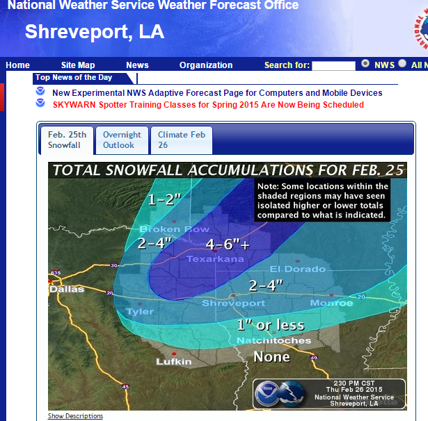
#6689 Postby aggiecutter » Thu Feb 26, 2015 10:20 pm

Snowfall totals from yesterday's storm from the NWS in Shreveport:

Image
0 likes   

User avatar
SouthernMet
Category 3
Category 3
Posts: 857
Joined: Sun Aug 29, 2010 8:23 pm
Location: fort worth, tx

Re: Texas Winter 2014-2015

#6690 Postby SouthernMet » Thu Feb 26, 2015 10:33 pm

though RGEM does appear to be an outlier, "drugs" have REALLY been working out for it so far this season.
0 likes   
Nothing that SouthernMet posts, is an official forecast,nor does it reflect views of STORM2K.. SouthernMet is just adding to the great discussions on STORM2K.. Refer to NWS for official forecasts.

orangeblood
S2K Supporter
S2K Supporter
Posts: 3334
Joined: Tue Dec 15, 2009 6:14 pm
Location: Fort Worth, TX

Re: Texas Winter 2014-2015

#6691 Postby orangeblood » Thu Feb 26, 2015 10:37 pm

SouthernMet wrote:though RGEM does appear to be an outlier, "drugs" have REALLY been working out for it so far this season.


Amounts are still a question mark but one thing appears to be more conclusive...the shortwave is taking direct aim at the metroplex, afternoon commute could be a little dicey, hopefully the school systems are paying attention.
0 likes   

User avatar
Portastorm
Storm2k Moderator
Storm2k Moderator
Posts: 9787
Age: 61
Joined: Fri Jul 11, 2003 9:16 am
Location: South Austin, TX
Contact:

Re: Texas Winter 2014-2015

#6692 Postby Portastorm » Thu Feb 26, 2015 10:41 pm

TexasF6 wrote:Porta, why is EWX so mysterious and acting like Austin is in for a surprise tomorrow??????!!!!!!!!!!!!!!!!!!!!! Worst case scenario is 1-2 inches according to the WPC model? RGEM is beautiful with snow first then ice!!!!??? What gives? :double: :froze:


Seems like they're not too bullish on the event and I can see why. Air column has to moisten a lot and then there needs to be enough isentropic lift to drop precip. There aren't any readily apparent triggers or vortmaxes or even ripples headed our way. Maybe some patchy sleet or freezing drizzle, very light.

I'd love it if the RGEM verified but I have my doubts. Sorry.
0 likes   
Any forecasts under my name are to be taken with a grain of salt. Get your best forecasts from the National Weather Service and National Hurricane Center.

I'm a certified Advanced SKYWARN-trained spotter and am active on Twitter at @TravisCOSW, a social media partner of the NWS Austin-San Antonio office.

Brent
S2K Supporter
S2K Supporter
Posts: 37123
Age: 35
Joined: Sun May 16, 2004 10:30 pm
Location: Tulsa Oklahoma
Contact:

Re: Texas Winter 2014-2015

#6693 Postby Brent » Thu Feb 26, 2015 11:08 pm

orangeblood wrote:
SouthernMet wrote:though RGEM does appear to be an outlier, "drugs" have REALLY been working out for it so far this season.


Amounts are still a question mark but one thing appears to be more conclusive...the shortwave is taking direct aim at the metroplex, afternoon commute could be a little dicey, hopefully the school systems are paying attention.


It's guaranteed to be snow and it's going to be a dry snow...

Aka, if the QPF amounts are even a few hundredths more it could be easily be a few more inches...

I could easily see nothing happening but at the same time if anything is going to overperform it's this

NBC 5 just said it's had thundersnow with it in New Mexico
0 likes   
#neversummer

Brent
S2K Supporter
S2K Supporter
Posts: 37123
Age: 35
Joined: Sun May 16, 2004 10:30 pm
Location: Tulsa Oklahoma
Contact:

Re: Texas Winter 2014-2015

#6694 Postby Brent » Thu Feb 26, 2015 11:46 pm

AREA FORECAST DISCUSSION...UPDATED
NATIONAL WEATHER SERVICE FORT WORTH TX
1015 PM CST THU FEB 26 2015

.UPDATE...
WITH A VERY COMPLEX FORECAST IN PLACE REGARDING TIMING AND EXACT
LOCATION WHERE SNOW BANDS SET UP FRIDAY MORNING...HAVE DECIDED THAT
CONFIDENCE WITH CURRENT FORECAST IS GOOD AND NO CHANGES WERE MADE.
CANNOT RULE SNOW POSSIBLY ENTERING FAR WESTERN COUNTIES JUST BEFORE
DAYBREAK...BUT THERE IS PLENTY OF DRY AIR BELOW 800MB ON TONIGHT/S
FWD SOUNDING TO OVERCOME AND DECIDED IT WILL TAKE TIME FOR TOP-DOWN
SATURATION. LATEST HIGH-RES MODELS OF THE HRRR, WRF, AND NAM MODELS
DO SHOW ABOUT A 1-2 HR SOONER ARRIVAL OF THE SNOW INTO THE I-35
CORRIDOR
FROM THE DFW METRO AND POINTS NORTH...AS THE BAND SETS UP
IN AN EAST-WEST ORIENTATION.

AT THIS TIME...THE MORNING RUSH SHOULD BE `OK`...BUT SNOW WILL
LIKELY ARRIVE BY 9 AM...IF NOT BETWEEN 8-9 AM IN THE WESTERN METRO
AND POINTS NORTH AND WEST. THIS SYSTEM DOES SHOW SOME MODEST
ELEVATED INSTABILITY. SO ANY CONVECTIVE SNOW BANDS OR SLIGHT SHIFT
NORTH OR SOUTH COULD HAVE QUITE AN EFFECT ON LOCATION...AMOUNTS
AND IMPACTS ALONG AND NORTH OF I-20 ON FRIDAY.

00Z MODELS ARE JUST NOW FLOWING IN...SO WILL ALLOW THE OVERNIGHT
FORECASTERS TO MAKE ANY ADJUSTMENTS IN LOCATION...AMOUNTS AND
IMPACTS WITH THE WINTER WEATHER ADVISORY.
0 likes   
#neversummer

User avatar
TheProfessor
Professional-Met
Professional-Met
Posts: 3505
Age: 27
Joined: Tue Dec 03, 2013 10:56 am
Location: Wichita, Kansas

#6695 Postby TheProfessor » Fri Feb 27, 2015 12:02 am

:uarrow: Leaving it for the next shift to handle lol. :lol:
0 likes   
An alumnus of The Ohio State University.

Your local National Weather Service office is your best source for weather information.

utweather
Tropical Storm
Tropical Storm
Posts: 234
Joined: Tue Jan 26, 2010 10:51 pm
Location: SE Austin, TX

Re:

#6696 Postby utweather » Fri Feb 27, 2015 12:08 am

TheProfessor wrote::uarrow: Leaving it for the next shift to handle lol. :lol:


Looks pretty potent with my non computer model eyes.
Even lots of flurries will look like major snow down here.
I need the disturbance to keep spinning southeast some more..
0 likes   

Brent
S2K Supporter
S2K Supporter
Posts: 37123
Age: 35
Joined: Sun May 16, 2004 10:30 pm
Location: Tulsa Oklahoma
Contact:

Re: Texas Winter 2014-2015

#6697 Postby Brent » Fri Feb 27, 2015 12:12 am

* ACCUMULATION...1 TO 2 INCHES OF SNOW FRIDAY...WITH LOCALIZED
HIGHER AMOUNTS TO 3 INCHES POSSIBLE.


That's new. :P

I even screenshotted the 4pm version and it didn't say 3 inches.
0 likes   
#neversummer

Brent
S2K Supporter
S2K Supporter
Posts: 37123
Age: 35
Joined: Sun May 16, 2004 10:30 pm
Location: Tulsa Oklahoma
Contact:

Re: Texas Winter 2014-2015

#6698 Postby Brent » Fri Feb 27, 2015 12:19 am

Image

Image
0 likes   
#neversummer

User avatar
Texas Snowman
Storm2k Moderator
Storm2k Moderator
Posts: 6041
Joined: Fri Jan 25, 2008 11:29 am
Location: Denison, Texas

Re: Texas Winter 2014-2015

#6699 Postby Texas Snowman » Fri Feb 27, 2015 12:33 am

Brent wrote:* ACCUMULATION...1 TO 2 INCHES OF SNOW FRIDAY...WITH LOCALIZED
HIGHER AMOUNTS TO 3 INCHES POSSIBLE.


That's new. :P

I even screenshotted the 4pm version and it didn't say 3 inches.


Yup, and this too:

THIS SYSTEM DOES SHOW SOME MODEST ELEVATED INSTABILITY. SO ANY CONVECTIVE SNOW BANDS OR SLIGHT SHIFT NORTH OR SOUTH COULD HAVE QUITE AN EFFECT ON LOCATION...AMOUNTS AND IMPACTS ALONG AND NORTH OF I-20 ON FRIDAY.
0 likes   
The above post and any post by Texas Snowman is NOT an official forecast and should not be used as such. It is just the opinion of the poster and may or may not be backed by sound meteorological data. It is NOT endorsed by any professional institution including storm2k.org. For official information, please refer to NWS products.

User avatar
Texas Snowman
Storm2k Moderator
Storm2k Moderator
Posts: 6041
Joined: Fri Jan 25, 2008 11:29 am
Location: Denison, Texas

Re: Texas Winter 2014-2015

#6700 Postby Texas Snowman » Fri Feb 27, 2015 12:40 am

Hmm, I don't remember seeing two to four inches forecast for the areas to the west and northwest of the D/FW Metroplex.

Maybe I missed that earlier this evening, but I think perhaps this graphic is new?

Image
0 likes   
The above post and any post by Texas Snowman is NOT an official forecast and should not be used as such. It is just the opinion of the poster and may or may not be backed by sound meteorological data. It is NOT endorsed by any professional institution including storm2k.org. For official information, please refer to NWS products.


Return to “Winter Weather”

Who is online

Users browsing this forum: No registered users and 75 guests