Texas Winter 2015-2016
Moderator: S2k Moderators
Forum rules
 The posts in this forum are NOT official forecast and should not be used as such. They are just the opinion of the poster and may or may not be backed by sound meteorological data. They are NOT endorsed by any professional institution or STORM2K.

The posts in this forum are NOT official forecast and should not be used as such. They are just the opinion of the poster and may or may not be backed by sound meteorological data. They are NOT endorsed by any professional institution or STORM2K.
-
TheProfessor

- Professional-Met

- Posts: 3505
- Age: 27
- Joined: Tue Dec 03, 2013 10:56 am
- Location: Wichita, Kansas
I just hope any thunder storms/ severe or not wait till I get home on the 15th, I want to hear some thunder! At this time of year here in Ohio all we seem to get is 40 mph wind gusts with rain, there isn't much instability so it gets quite boring to be honest. (boring might be the wrong word as rain is never boring but its not as exciting as hearing the rumbles of thunder!)
0 likes
An alumnus of The Ohio State University.
Your local National Weather Service office is your best source for weather information.
Your local National Weather Service office is your best source for weather information.
-
Tireman4

- S2K Supporter

- Posts: 5674
- Age: 58
- Joined: Fri Jun 30, 2006 1:08 pm
- Location: Humble, Texas
- Contact:
Re:
TheProfessor wrote:I just hope any thunder storms/ severe or not wait till I get home on the 15th, I want to hear some thunder! At this time of year here in Ohio all we seem to get is 40 mph wind gusts with rain, there isn't much instability so it gets quite boring to be honest. (boring might be the wrong word as rain is never boring but its not as exciting as hearing the rumbles of thunder!)
But you had snow...are you close to making the Dean's List?
0 likes
Re:
weatherdude1108 wrote::uarrow:
What kind of big storm?
Heights fall significantly across the southern Rockies. A potential multi facet deep system.
Does appear another -EPO induced active pattern past mid month with raised heights off the west coast of NA
0 likes
The above post and any post by Ntxw is NOT an official forecast and should not be used as such. It is just the opinion of the poster and may or may not be backed by sound meteorological data. It is NOT endorsed by any professional institution including Storm2k. For official information, please refer to NWS products.
Help support Storm2K!
-
TheProfessor
- Professional-Met
- Posts: 3505
- Age: 27
- Joined: Tue Dec 03, 2013 10:56 am
- Location: Wichita, Kansas
Re: Re:
Tireman4 wrote:TheProfessor wrote:I just hope any thunder storms/ severe or not wait till I get home on the 15th, I want to hear some thunder! At this time of year here in Ohio all we seem to get is 40 mph wind gusts with rain, there isn't much instability so it gets quite boring to be honest. (boring might be the wrong word as rain is never boring but its not as exciting as hearing the rumbles of thunder!)
But you had snow...are you close to making the Dean's List?
I haven't seen any snow yet
0 likes
An alumnus of The Ohio State University.
Your local National Weather Service office is your best source for weather information.
Your local National Weather Service office is your best source for weather information.

Re: Texas Winter 2015-2016
Of course it's all still a good ways off with at least 7 days of calm which will be quite nice actually. Hopefully by next Wednesday, there will be solid signs of our next big storm system.
0 likes
Resident Rain Miser
I am a weather hobbyist living 3.5 miles south of Downtown Austin and in no way or fashion should anything I say concerning forecasts be taken seriously. Please check your local NWS for accurate weather forecasting and conditions.
I am a weather hobbyist living 3.5 miles south of Downtown Austin and in no way or fashion should anything I say concerning forecasts be taken seriously. Please check your local NWS for accurate weather forecasting and conditions.
-
wxman57

- Moderator-Pro Met

- Posts: 22480
- Age: 66
- Joined: Sat Jun 21, 2003 8:06 pm
- Location: Houston, TX (southwest)
Re: Texas Winter 2015-2016
12Z GFS doesn't indicate any interesting weather across Texas through the 18th. Moderately strong cold front mid-month. Could get close to freezing across SE TX with that front. Nothing out of the ordinary, though. Little in the way of precip next 2 weeks.
0 likes
-
weatherdude1108
- Category 5

- Posts: 4172
- Joined: Tue Dec 13, 2011 1:04 pm
- Location: Northwest Austin/Cedar Park, TX
Bob Rose mention something about unsettled weather late next week in yesterday's blog, based on yesterday's model. Just saw it.
Today's extended-range solutions indicate the pattern will become more unsettled late next week when a large trough of low pressure pushes east out of the southwestern US. This system has the potential to bring rain and storms to Central Texas sometime next Friday or Saturday. Stay tuned for more details.
Bob
http://www.lcra.org/water/river-and-wea ... ather.aspx
0 likes
The preceding post is NOT an official forecast, and should not be used as such. It is only the opinion of the poster and may or may not be backed by sound meteorological data. It is NOT endorsed by any professional institution including storm2k.org. For Official Information please refer to the NHC and NWS products.
-
Portastorm

- Storm2k Moderator

- Posts: 9787
- Age: 61
- Joined: Fri Jul 11, 2003 9:16 am
- Location: South Austin, TX
- Contact:
Re: Re:
Ntxw wrote:weatherdude1108 wrote::uarrow:
What kind of big storm?
Heights fall significantly across the southern Rockies. A potential multi facet deep system.
Does appear another -EPO induced active pattern past mid month with raised heights off the west coast of NA
Indeed. Both the GFS and Euro suggest as much by mid month. Looks like a massive, full latitude trough over much of the western CONUS. Will be interesting to watch how it develops.
0 likes
Any forecasts under my name are to be taken with a grain of salt. Get your best forecasts from the National Weather Service and National Hurricane Center.
I'm a certified Advanced SKYWARN-trained spotter and am active on Twitter at @TravisCOSW, a social media partner of the NWS Austin-San Antonio office.
I'm a certified Advanced SKYWARN-trained spotter and am active on Twitter at @TravisCOSW, a social media partner of the NWS Austin-San Antonio office.
-
orangeblood
- S2K Supporter
- Posts: 3334
- Joined: Tue Dec 15, 2009 6:14 pm
- Location: Fort Worth, TX
Re: Re:
Portastorm wrote:Ntxw wrote:weatherdude1108 wrote::uarrow:
What kind of big storm?
Heights fall significantly across the southern Rockies. A potential multi facet deep system.
Does appear another -EPO induced active pattern past mid month with raised heights off the west coast of NA
Indeed. Both the GFS and Euro suggest as much by mid month. Looks like a massive, full latitude trough over much of the western CONUS. Will be interesting to watch how it develops.
GFS Ensembles showing significant cold air anomalies from Mississippi River westward around mid-month as well....as we've seen in years past, those type anomalies are usually a very telling sign from 10 + days out!!! This appears to be a prime winter weather synoptic setup for those in West Texas into New Mexico.
0 likes
-
CaptinCrunch

- S2K Supporter
- Posts: 8569
- Age: 56
- Joined: Mon Nov 03, 2003 4:33 pm
- Location: Lake Worth, TX (Tarrant Co.)
I read a blog yesterday that mentioned a possible winter storm system for Texas starting the week of the 21st. Till then going to be nice and seasonal. One other thing that was mentioned was big weather pattern change going into the first of the year that will put Texas in a position for several chances of winter precip right through the end of the January.
0 likes
Re: Re:
orangeblood wrote:
GFS Ensembles showing significant cold air anomalies from Mississippi River westward around mid-month as well....as we've seen in years past, those type anomalies are usually a very telling sign from 10 + days out!!! This appears to be a prime winter weather synoptic setup for those in West Texas into New Mexico.
-SOI tank underway. Supports major system after the first half of the month. Models may be too fast but when the SOI tanks in DJF you listen in terms of storm signal.
0 likes
The above post and any post by Ntxw is NOT an official forecast and should not be used as such. It is just the opinion of the poster and may or may not be backed by sound meteorological data. It is NOT endorsed by any professional institution including Storm2k. For official information, please refer to NWS products.
Help support Storm2K!
Help support Storm2K!
-
BigB0882
- S2K Supporter
- Posts: 2219
- Joined: Thu Jul 03, 2003 12:08 am
- Location: Baton Rouge, LA
- Contact:
Re: Texas Winter 2015-2016
I knew SELA was going to get screwed this winter. The cold will be just out of reach, watch! Winter cancel!!! 

0 likes
-
Ralph's Weather
- S2K Supporter
- Posts: 2968
- Age: 36
- Joined: Fri Dec 13, 2013 11:55 am
- Location: Lindale, TX
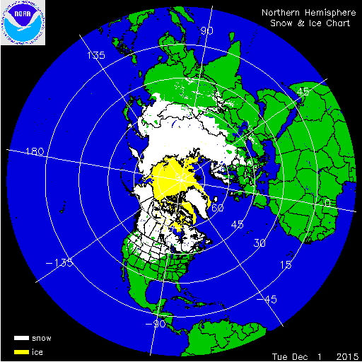
Anyone taken a look at the H Hem snow cover map? Pretty impressive coverage from northern China down to Kansas.

0 likes
Follow on Facebook at Ralph's Weather.
0 likes
The above post and any post by Ntxw is NOT an official forecast and should not be used as such. It is just the opinion of the poster and may or may not be backed by sound meteorological data. It is NOT endorsed by any professional institution including Storm2k. For official information, please refer to NWS products.
Help support Storm2K!
Help support Storm2K!
Re:
Ralph's Weather wrote:Anyone taken a look at the H Hem snow cover map? Pretty impressive coverage from northern China down to Kansas.
http://i894.photobucket.com/albums/ac147/rbaker1987/Weather/2015-12-02_NHem_SnowCoverage_zpsch7uzu4c.gif
I love how that was worded, from China down to Kansas, like it is some easy geographical point from A to B. This is why I love weather and geography as much as I do, and the sharing of this knowledge on Storm2k. Case in point, the curvature of the earth on Ralphs snow map is not fully shown, and me being a weather and map nerd made me get excited. Little things like that really interest me. Even Mongolia is in the mix. Soviet snow is good, we need some of that cold and snow on our side of the Northern Hemisphere. Hope I am not boring ya'll.

0 likes
-
Texas Snowman

- Storm2k Moderator
- Posts: 6011
- Joined: Fri Jan 25, 2008 11:29 am
- Location: Denison, Texas
Oh, come on gang. Aren't y'all ignoring the post above? You know, the one from Wxman57 above, the one that says there will be nothing out of the ordinary and little precip.
Winter cancel, don't you know?
Winter cancel, don't you know?
0 likes
The above post and any post by Texas Snowman is NOT an official forecast and should not be used as such. It is just the opinion of the poster and may or may not be backed by sound meteorological data. It is NOT endorsed by any professional institution including storm2k.org. For official information, please refer to NWS products.
Re:
Texas Snowman wrote:Oh, come on gang. Aren't y'all ignoring the post above? You know, the one from Wxman57 above, the one that says there will be nothing out of the ordinary and little precip.
Winter cancel, don't you know?
Pfff it could be winter cancel, for eastern Canada and the Great Lakes! Could be one of the warmest ever for them. Wxman57 is living in the wrong place, one of the coolest spots on the continent to normal winter 2015-2016
Speaking of warmth, you don't see those kind of deep reds (up near great lakes) from the CPC everyday.

0 likes
The above post and any post by Ntxw is NOT an official forecast and should not be used as such. It is just the opinion of the poster and may or may not be backed by sound meteorological data. It is NOT endorsed by any professional institution including Storm2k. For official information, please refer to NWS products.
Help support Storm2K!
Help support Storm2K!
-
Ralph's Weather
- S2K Supporter
- Posts: 2968
- Age: 36
- Joined: Fri Dec 13, 2013 11:55 am
- Location: Lindale, TX
Re: Re:
gpsnowman wrote:Ralph's Weather wrote:Anyone taken a look at the H Hem snow cover map? Pretty impressive coverage from northern China down to Kansas.
I love how that was worded, from China down to Kansas, like it is some easy geographical point from A to B. This is why I love weather and geography as much as I do, and the sharing of this knowledge on Storm2k. Case in point, the curvature of the earth on Ralphs snow map is not fully shown, and me being a weather and map nerd made me get excited. Little things like that really interest me. Even Mongolia is in the mix. Soviet snow is good, we need some of that cold and snow on our side of the Northern Hemisphere. Hope I am not boring ya'll.
Maybe late this winter this map will show white from the Himalayas to N Mexico. Things are shaping up beautifully for a great winter for Texas if you like snow. Hoping that widespread areas north of I-20 get 12"+ this winter and maybe a few 24" totals. And this is a good set up to see snow further south too.
0 likes
Follow on Facebook at Ralph's Weather.
-
1900hurricane

- Category 5
- Posts: 6044
- Age: 32
- Joined: Fri Feb 06, 2015 12:04 pm
- Location: Houston, TX
- Contact:
I realize I'm talking about something 9-10 days out, but the last 00Z GFS is considerably less junky in advance of the big trough, which would allow a more robust warm sector and better storm chances. If the parade of little SE moving systems like the 12Z showed were to verify, moisture would be shunted away for longer, hurting storm chances. The difference between the two runs with respect to available low level moisture is noteworthy.
0 likes
Contract Meteorologist. TAMU & MSST. Fiercely authentic, one of a kind. We are all given free will, so choose a life meant to be lived. We are the Masters of our own Stories.
Opinions expressed are mine alone.
Follow me on Twitter at @1900hurricane : Read blogs at https://1900hurricane.wordpress.com/
Opinions expressed are mine alone.
Follow me on Twitter at @1900hurricane : Read blogs at https://1900hurricane.wordpress.com/

Who is online
Users browsing this forum: Google [Bot] and 78 guests