Texas Winter 2017-2018

Winter Weather Discussion

Moderator: S2k Moderators

Forum rules

The posts in this forum are NOT official forecast and should not be used as such. They are just the opinion of the poster and may or may not be backed by sound meteorological data. They are NOT endorsed by any professional institution or STORM2K.

Help Support Storm2K
Message
Author
weatherdude1108
Category 5
Category 5
Posts: 4172
Joined: Tue Dec 13, 2011 1:04 pm
Location: Northwest Austin/Cedar Park, TX

Re: Texas Winter 2017-2018

#9121 Postby weatherdude1108 » Thu Feb 22, 2018 9:32 pm

Ntxw wrote:
weatherdude1108 wrote:
Ntxw wrote:SOI has ended the negative streak. Also stronger trades will return to the dateline. About 2 weeks or so down the road we may see a period of below normal precipitation if this holds value. SOI looks overall positive values the rest of Feb


Looks like it trended negative on February 20th? It's at -0.40 now. I know you all could use a break from the rain, but we could use more down here.

https://www.longpaddock.qld.gov.au/seas ... soivalues/


The daily SOI is +14 for 2/22 driven by higher pressures near Tahiti the next week. The monthly SOI is what has already occured

The daily is what you want to look at, 30 and 90 day is for ENSO purposes


Ahhh. That shows how little I know about SOI. :oops:

And here I was, feeling all cool with my SOI acronym. :lol:

Seriously though, thanks for the feedback. :wink:
0 likes   
The preceding post is NOT an official forecast, and should not be used as such. It is only the opinion of the poster and may or may not be backed by sound meteorological data. It is NOT endorsed by any professional institution including storm2k.org. For Official Information please refer to the NHC and NWS products.

Ntxw
Storm2k Moderator
Storm2k Moderator
Posts: 21494
Joined: Wed Oct 21, 2009 6:34 pm
Location: DFW, Texas

Re: Texas Winter 2017-2018

#9122 Postby Ntxw » Thu Feb 22, 2018 9:38 pm

weatherdude1108 wrote:Ahhh. That shows how little I know about SOI. :oops:

And here I was, feeling all cool with my SOI acronym. :lol:

Seriously though, thanks for the feedback. :wink:


No problem! It is one of my favorite ENSO tools!

When you want to look for wet pattern down the road, you will start to see daily SOI dive negative -10s/-20s or more for many consecutive days. Dry periods are the opposite.
30 and 90 day SOI are averages of the SOI values accordingly the past month and 3 months.

During El Nino the 30 and 90 day SOI generally will average -8 or greater, the greater the value the more intense the Nino *generally*
During La Nina the same but positive (+8s and greater).

Thus no coincidence in an El Nino year you will see many days negative going months and months, and generally our patterns are very wet. Vice versa for La Nina.

February while in a La Nina, the SOI is one of the atmospheric measures that show more similarities with El Nino with the persistent negatives, thus we had the wetter pattern.
2 likes   
The above post and any post by Ntxw is NOT an official forecast and should not be used as such. It is just the opinion of the poster and may or may not be backed by sound meteorological data. It is NOT endorsed by any professional institution including Storm2k. For official information, please refer to NWS products.

  Help support Storm2K!
Help Support Storm2K

User avatar
Haris
Category 5
Category 5
Posts: 1808
Joined: Mon Nov 27, 2017 8:19 pm
Location: ( Bee Cave) West Austin, Texas

Re: Texas Winter 2017-2018

#9123 Postby Haris » Thu Feb 22, 2018 10:00 pm

Anybody know where all this surprise rain is firing up from in the hill co. That shortwave wasnt supposed to bring precip this early?
0 likes   
Weather geek and a storm spotter in West Austin. Not a degreed meteorologist. Big snow fan. Love rain and cold! Despise heat!

downsouthman1
Category 2
Category 2
Posts: 652
Age: 44
Joined: Fri Jan 07, 2011 8:14 pm
Location: Manor, TX

Re: Texas Winter 2017-2018

#9124 Postby downsouthman1 » Thu Feb 22, 2018 10:03 pm

Haris wrote:Anybody know where all this surprise rain is firing up from in the hill co. That shortwave wasnt supposed to bring precip this early?

Whoa! I haven't looked at radar in 2 hours and all that wasn't there then!
3 likes   
Not a professional MET! My posts are merely speculation.

User avatar
South Texas Storms
Professional-Met
Professional-Met
Posts: 4003
Joined: Thu Jun 24, 2010 12:28 am
Location: Houston, TX

Re: Texas Winter 2017-2018

#9125 Postby South Texas Storms » Thu Feb 22, 2018 10:30 pm

Haris wrote:Anybody know where all this surprise rain is firing up from in the hill co. That shortwave wasnt supposed to bring precip this early?


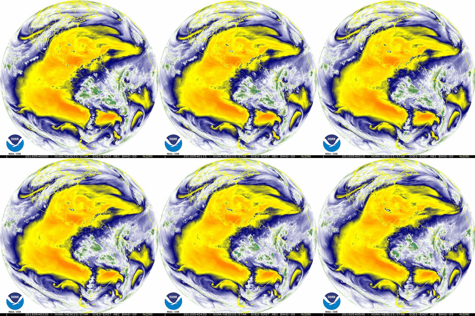
Yeah you're right. All models had SA and Austin getting rain after midnight tonight. It's definitely starting earlier than expected, and I think it's due to the active subtropical jet stream overhead. Take a look at the Pacific satellite image than Ntxw posted on the previous page. Tons of moisture streaming in from the eastern Pacific Ocean. Sometimes the models can't see the little embedded disturbances in there.
2 likes   

hamburgerman7070
Category 1
Category 1
Posts: 253
Joined: Sat Dec 02, 2017 7:39 pm
Location: Jonesboro ar

Re: Texas Winter 2017-2018

#9126 Postby hamburgerman7070 » Thu Feb 22, 2018 10:40 pm

http://www.daculaweather.com/4_mjo_phase_forecast.php#

This is the up to date Australians mjo chart. CPC hasn't updated in two days. The one in the sw part of the screen.
1 likes   

User avatar
Haris
Category 5
Category 5
Posts: 1808
Joined: Mon Nov 27, 2017 8:19 pm
Location: ( Bee Cave) West Austin, Texas

Re: Texas Winter 2017-2018

#9127 Postby Haris » Thu Feb 22, 2018 10:53 pm

South Texas Storms wrote:
Haris wrote:Anybody know where all this surprise rain is firing up from in the hill co. That shortwave wasnt supposed to bring precip this early?


Yeah you're right. All models had SA and Austin getting rain after midnight tonight. It's definitely starting earlier than expected, and I think it's due to the active subtropical jet stream overhead. Take a look at the Pacific satellite image than Ntxw posted on the previous page. Tons of moisture streaming in from the eastern Pacific Ocean. Sometimes the models can't see the little embedded disturbances in there.


Lotta lightning and heavy rain at the Harry weather center. Finally! Hope we get more :)
2 likes   
Weather geek and a storm spotter in West Austin. Not a degreed meteorologist. Big snow fan. Love rain and cold! Despise heat!

User avatar
bubba hotep
S2K Supporter
S2K Supporter
Posts: 5454
Joined: Wed Dec 28, 2016 1:00 am
Location: Collin County Texas

Re: Texas Winter 2017-2018

#9128 Postby bubba hotep » Thu Feb 22, 2018 10:58 pm

WAA showers?

Warm front shows up nicely here

Image

Once again, warm front with southerly flow into Houston/SE TX and shallow northerly flow into the Hill Country

Image

Warm 850mb return flow over the top of the cold air

Image

Little bit of lift showing in the 500mb vort field

Image
1 likes   
Winter time post are almost exclusively focused on the DFW area.

weatherdude1108
Category 5
Category 5
Posts: 4172
Joined: Tue Dec 13, 2011 1:04 pm
Location: Northwest Austin/Cedar Park, TX

Re: Texas Winter 2017-2018

#9129 Postby weatherdude1108 » Thu Feb 22, 2018 11:03 pm

Haris wrote:
South Texas Storms wrote:
Haris wrote:Anybody know where all this surprise rain is firing up from in the hill co. That shortwave wasnt supposed to bring precip this early?


Yeah you're right. All models had SA and Austin getting rain after midnight tonight. It's definitely starting earlier than expected, and I think it's due to the active subtropical jet stream overhead. Take a look at the Pacific satellite image than Ntxw posted on the previous page. Tons of moisture streaming in from the eastern Pacific Ocean. Sometimes the models can't see the little embedded disturbances in there.


Lotta lightning and heavy rain at the Harry weather center. Finally! Hope we get more :)


Yeah, I'm getting a lot of lightning/thunder and spurts of heavy rain. This stuff developed fast. So weird at 42 degrees. Chilly and stormy!
1 likes   
The preceding post is NOT an official forecast, and should not be used as such. It is only the opinion of the poster and may or may not be backed by sound meteorological data. It is NOT endorsed by any professional institution including storm2k.org. For Official Information please refer to the NHC and NWS products.

User avatar
South Texas Storms
Professional-Met
Professional-Met
Posts: 4003
Joined: Thu Jun 24, 2010 12:28 am
Location: Houston, TX

Re: Texas Winter 2017-2018

#9130 Postby South Texas Storms » Thu Feb 22, 2018 11:05 pm

:uarrow:
Yeah that's a plausible reason as well.

0z NAM also shows a nice complex of storms moving northeastward out of Mexico early tomorrow morning reaching the SA and Austin areas around daybreak. Hope it verifies! Sure would be nice if areas that missed out earlier this week could get some beneficial rainfall with this disturbance.
3 likes   

User avatar
Haris
Category 5
Category 5
Posts: 1808
Joined: Mon Nov 27, 2017 8:19 pm
Location: ( Bee Cave) West Austin, Texas

Re: Texas Winter 2017-2018

#9131 Postby Haris » Thu Feb 22, 2018 11:11 pm

South Texas Storms wrote::uarrow:
Yeah that's a plausible reason as well.

0z NAM also shows a nice complex of storms moving northeastward out of Mexico early tomorrow morning reaching the SA and Austin areas around daybreak. Hope it verifies! Sure would be nice if areas that missed out earlier this week could get some beneficial rainfall with this disturbance.


This could be good. Seeing radar of del rio, radar beams showing lots of rain in NE Mexico moving towards Austin. All the rain in SATX beginning to move N towards ATX too. We could be seeing a decent rain event unfolding. Maybeee?
3 likes   
Weather geek and a storm spotter in West Austin. Not a degreed meteorologist. Big snow fan. Love rain and cold! Despise heat!

User avatar
South Texas Storms
Professional-Met
Professional-Met
Posts: 4003
Joined: Thu Jun 24, 2010 12:28 am
Location: Houston, TX

Re: Texas Winter 2017-2018

#9132 Postby South Texas Storms » Thu Feb 22, 2018 11:20 pm

Haris wrote:
South Texas Storms wrote::uarrow:
Yeah that's a plausible reason as well.

0z NAM also shows a nice complex of storms moving northeastward out of Mexico early tomorrow morning reaching the SA and Austin areas around daybreak. Hope it verifies! Sure would be nice if areas that missed out earlier this week could get some beneficial rainfall with this disturbance.


This could be good. Seeing radar of del rio, radar beams showing lots of rain in NE Mexico moving towards Austin. All the rain in SATX beginning to move N towards ATX too. We could be seeing a decent rain event unfolding. Maybeee?


That's the hope! There is still a lot of moisture back in Mexico with the disturbance. Radar echoes continue to increase across northeastern Mexico. Bring on the rain!
1 likes   

downsouthman1
Category 2
Category 2
Posts: 652
Age: 44
Joined: Fri Jan 07, 2011 8:14 pm
Location: Manor, TX

Re: Texas Winter 2017-2018

#9133 Postby downsouthman1 » Thu Feb 22, 2018 11:48 pm

This activity around Austin San Antonio will drift east very slowly.

Holy Moly. This developed out of nothing. Austin radar!
0 likes   
Not a professional MET! My posts are merely speculation.

Ntxw
Storm2k Moderator
Storm2k Moderator
Posts: 21494
Joined: Wed Oct 21, 2009 6:34 pm
Location: DFW, Texas

Re: Texas Winter 2017-2018

#9134 Postby Ntxw » Fri Feb 23, 2018 1:05 am

Yeah it's not too surprising considering what is going on. Weak disturbances are riding the subtropical jet fed from the Pacific, models are not always great with this. You can clearly depict the "highway" of mid level moisture. PWATS are rather high too so once you get the storms going, efficient rain makers.

Image
2 likes   
The above post and any post by Ntxw is NOT an official forecast and should not be used as such. It is just the opinion of the poster and may or may not be backed by sound meteorological data. It is NOT endorsed by any professional institution including Storm2k. For official information, please refer to NWS products.


  Help support Storm2K!

Help Support Storm2K


downsouthman1
Category 2
Category 2
Posts: 652
Age: 44
Joined: Fri Jan 07, 2011 8:14 pm
Location: Manor, TX

Re: Texas Winter 2017-2018

#9135 Postby downsouthman1 » Fri Feb 23, 2018 1:22 am

:uarrow: So a ridge and a low are channeling the moisture straight over TX.
0 likes   
Not a professional MET! My posts are merely speculation.

Brent
S2K Supporter
S2K Supporter
Posts: 37087
Age: 35
Joined: Sun May 16, 2004 10:30 pm
Location: Tulsa Oklahoma
Contact:

Re: Texas Winter 2017-2018

#9136 Postby Brent » Fri Feb 23, 2018 1:53 am

here we go again... loud thunderstorm and pouring rain in waterlogged eastern Dallas

Looks to be training right over Rockwall too

I don't want to hear about the drought again for awhile. :P

I havent even seen the sun since I was in NYC :roflmao:
0 likes   
#neversummer

gpsnowman
S2K Supporter
S2K Supporter
Posts: 2710
Joined: Fri Jan 07, 2011 10:35 am
Location: Grand Prairie Tx

Re: Texas Winter 2017-2018

#9137 Postby gpsnowman » Fri Feb 23, 2018 3:57 am

Who needs an alarm clock at 3:20 when mother nature can provide one at 2:40? Bright lightning and loud tbunder will do that. Good morning rain lovers. Wakey, wakey.
1 likes   

User avatar
EnnisTx
S2K Supporter
S2K Supporter
Posts: 896
Joined: Sat Dec 26, 2015 4:06 pm
Location: Albany, Texas
Contact:

Re: Texas Winter 2017-2018

#9138 Postby EnnisTx » Fri Feb 23, 2018 6:17 am

Looks like the folks down in San Antonio and Austin will get a nice share of the rain this morning. Nice returns down that way...
1 likes   

User avatar
wxman57
Moderator-Pro Met
Moderator-Pro Met
Posts: 22480
Age: 66
Joined: Sat Jun 21, 2003 8:06 pm
Location: Houston, TX (southwest)

Re: Texas Winter 2017-2018

#9139 Postby wxman57 » Fri Feb 23, 2018 6:35 am

Front is still hung up over Houston. It moved to my north yesterday afternoon, but slipped a few miles south of my house overnight. Down to 63 now. Noticed that my azaleas are full of flower buds.

(t-25 days)
0 likes   

User avatar
Texas Snowman
Storm2k Moderator
Storm2k Moderator
Posts: 6011
Joined: Fri Jan 25, 2008 11:29 am
Location: Denison, Texas

Re: Texas Winter 2017-2018

#9140 Postby Texas Snowman » Fri Feb 23, 2018 6:50 am

It’s 36 in Denison with a frog strangling tropical downpour going on (with some thunder and lightning).

Ice storm a day ago, a number of people still without power. Flash flood watch today with cold rain on tap.

Still wintertime here in the Red River Valley.
1 likes   
The above post and any post by Texas Snowman is NOT an official forecast and should not be used as such. It is just the opinion of the poster and may or may not be backed by sound meteorological data. It is NOT endorsed by any professional institution including storm2k.org. For official information, please refer to NWS products.


Return to “Winter Weather”

Who is online

Users browsing this forum: No registered users and 94 guests