Texas Winter 2017-2018

Winter Weather Discussion

Moderator: S2k Moderators

Forum rules

The posts in this forum are NOT official forecast and should not be used as such. They are just the opinion of the poster and may or may not be backed by sound meteorological data. They are NOT endorsed by any professional institution or STORM2K.

Help Support Storm2K
Message
Author
Ntxw
Storm2k Moderator
Storm2k Moderator
Posts: 21514
Joined: Wed Oct 21, 2009 6:34 pm
Location: DFW, Texas

Re: Texas Winter 2017-2018

#9181 Postby Ntxw » Sat Feb 24, 2018 11:00 am

The EPO is something also to watch. While the AO/NAO couplet is nice, we can add some surface cold with it when/if the EPO plays along

Image

March 1-5 or so seems to be the convergence point of the indexes peaking negative.
0 likes   
The above post and any post by Ntxw is NOT an official forecast and should not be used as such. It is just the opinion of the poster and may or may not be backed by sound meteorological data. It is NOT endorsed by any professional institution including Storm2k. For official information, please refer to NWS products.

  Help support Storm2K!
Help Support Storm2K

Ntxw
Storm2k Moderator
Storm2k Moderator
Posts: 21514
Joined: Wed Oct 21, 2009 6:34 pm
Location: DFW, Texas

Re: Texas Winter 2017-2018

#9182 Postby Ntxw » Sat Feb 24, 2018 11:04 am

For those of you looking to do early planting, the teleconnections is pointing in the direction of a late season freeze (I-20 and north). These indexes are not on the side you want to transplant into the ground. I'd wait a little longer.
1 likes   
The above post and any post by Ntxw is NOT an official forecast and should not be used as such. It is just the opinion of the poster and may or may not be backed by sound meteorological data. It is NOT endorsed by any professional institution including Storm2k. For official information, please refer to NWS products.


  Help support Storm2K!

Help Support Storm2K


User avatar
northjaxpro
S2K Supporter
S2K Supporter
Posts: 8900
Joined: Mon Sep 27, 2010 11:21 am
Location: Jacksonville, FL

Re: Texas Winter 2017-2018

#9183 Postby northjaxpro » Sat Feb 24, 2018 11:07 am

srainhoutx wrote:I continue to see the return of chilly and possibly wet weather the first full week of March in the longer range GEFS Ensemble schemes. The Teleconnection Indices continue to advertise a extremely negative Arctic Oscillation and extremely negative North Atlantic Oscillation as a result of the Sudden Stratospheric Warming Event that happen last week. This sort of Northern Hemispheric Blocking pattern is capable of ushering in much colder air across a large expanse of North America including Texas.


Yes, indeed. I have been anticipating this pattern change since the second week of February and it looks like the period from March 3 - March 10 will be when we see the big changes occur, especially across the Eastern CONUS. Old Man Winter is not quite done with us yet folks! I mentioned in the Deep South Winter thread last weekend for folks not to start planting the spring garden too early, with this pattern change in mind.
1 likes   
NEVER, EVER SAY NEVER in the tropics and weather in general, and most importantly, with life itself!!

________________________________________________________________________________________

Fay 2008 Beryl 2012 Debby 2012 Colin 2016 Hermine 2016 Julia 2016 Matthew 2016 Irma 2017 Dorian 2019

Ntxw
Storm2k Moderator
Storm2k Moderator
Posts: 21514
Joined: Wed Oct 21, 2009 6:34 pm
Location: DFW, Texas

Re: Texas Winter 2017-2018

#9184 Postby Ntxw » Sat Feb 24, 2018 11:12 am

After picking up a little over half inch of rain at DFW this morning, another batch is coming through

Image
0 likes   
The above post and any post by Ntxw is NOT an official forecast and should not be used as such. It is just the opinion of the poster and may or may not be backed by sound meteorological data. It is NOT endorsed by any professional institution including Storm2k. For official information, please refer to NWS products.


  Help support Storm2K!

Help Support Storm2K


rwfromkansas
Category 5
Category 5
Posts: 2188
Joined: Sat Aug 27, 2005 12:47 am
Location: North Fort Worth

Re: Texas Winter 2017-2018

#9185 Postby rwfromkansas » Sat Feb 24, 2018 11:36 am

Now over 4 inches for the event in north FW. Some areas close are higher, but had a couple "near misses" on some heavy storms so a little less here. But, that's extremely impressive for February. Extremely. And the totals just a bit further east are insane. Looks like DFW will end up getting a wetter start than even last year this time, which was also pretty good. That's important to rack up totals before summer comes.
0 likes   

gpsnowman
S2K Supporter
S2K Supporter
Posts: 2716
Joined: Fri Jan 07, 2011 10:35 am
Location: Grand Prairie Tx

Re: Texas Winter 2017-2018

#9186 Postby gpsnowman » Sat Feb 24, 2018 11:48 am

All the rain this week has been awesome. Loved every minute of it. But all good things must end, I'm ready for some sunshine and drier air.
3 likes   

downsouthman1
Category 2
Category 2
Posts: 652
Age: 44
Joined: Fri Jan 07, 2011 8:14 pm
Location: Manor, TX

Re: Texas Winter 2017-2018

#9187 Postby downsouthman1 » Sat Feb 24, 2018 12:07 pm

gpsnowman wrote:All the rain this week has been awesome. Loved every minute of it. But all good things must end, I'm ready for some sunshine and drier air.

I would feel the same if I got 10" rain in 3 days. But we still need a lot of rain here.
1 likes   
Not a professional MET! My posts are merely speculation.

User avatar
Haris
Category 5
Category 5
Posts: 1808
Joined: Mon Nov 27, 2017 8:19 pm
Location: ( Bee Cave) West Austin, Texas

Re: Texas Winter 2017-2018

#9188 Postby Haris » Sat Feb 24, 2018 12:37 pm

Ntxw wrote:After picking up a little over half inch of rain at DFW this morning, another batch is coming through

Image


So NTXW, while Austin wintry weather chances are 0, will we see decent rains around the area. For early March
0 likes   
Weather geek and a storm spotter in West Austin. Not a degreed meteorologist. Big snow fan. Love rain and cold! Despise heat!

Ntxw
Storm2k Moderator
Storm2k Moderator
Posts: 21514
Joined: Wed Oct 21, 2009 6:34 pm
Location: DFW, Texas

Re: Texas Winter 2017-2018

#9189 Postby Ntxw » Sat Feb 24, 2018 1:07 pm

:uarrow: There will be additional chances for rainfall in the state for about 2 more weeks into mid March. With the western trough in place and the lag effect of the past -SOI will keep the STJ active. Beyond that we will begin to feel the +SOI happening now along with stronger tradewinds near the dateline. That will shut the Pacific linkage off second half of March.
0 likes   
The above post and any post by Ntxw is NOT an official forecast and should not be used as such. It is just the opinion of the poster and may or may not be backed by sound meteorological data. It is NOT endorsed by any professional institution including Storm2k. For official information, please refer to NWS products.


  Help support Storm2K!

Help Support Storm2K


aggiecutter
Category 5
Category 5
Posts: 1743
Joined: Thu Oct 14, 2004 9:22 pm
Location: Texarkana

Re: Texas Winter 2017-2018

#9190 Postby aggiecutter » Sat Feb 24, 2018 1:26 pm

TORNADO WATCH OUTLINE UPDATE FOR WT 4
NWS STORM PREDICTION CENTER NORMAN OK
1100 AM CST SAT FEB 24 2018

TORNADO WATCH 4 IS IN EFFECT UNTIL 600 PM CST FOR THE
FOLLOWING LOCATIONS

TXC037-063-067-119-159-183-203-223-277-315-343-379-387-423-449-
459-467-499-250000-
/O.NEW.KWNS.TO.A.0004.180224T1700Z-180225T0000Z/

TX
. TEXAS COUNTIES INCLUDED ARE

BOWIE CAMP CASS
DELTA FRANKLIN GREGG
HARRISON HOPKINS LAMAR
MARION MORRIS RAINS
RED RIVER SMITH TITUS
UPSHUR VAN ZANDT WOOD
$$
0 likes   

User avatar
opticsguy
S2K Supporter
S2K Supporter
Posts: 203
Joined: Wed Jan 05, 2011 9:27 pm
Location: Far North Dallas

Re: Texas Winter 2017-2018

#9191 Postby opticsguy » Sat Feb 24, 2018 3:22 pm

My tomatoes have been growing under lights since mid-January. They need to be outside. This is the critical time to get enough of a growing season before hot weather diseases kick in. I'm going to plant tomorrow and be prepared to dig them up if a freeze comes. Under 40F will put them into shock but a few warm sunny days fixes that.
0 likes   

User avatar
TeamPlayersBlue
Category 5
Category 5
Posts: 3308
Joined: Tue Feb 02, 2010 1:44 am
Location: Denver/Applewood, CO

Re: Texas Winter 2017-2018

#9192 Postby TeamPlayersBlue » Sat Feb 24, 2018 3:53 pm

srainhoutx wrote:We folks in S Central and SE Texas will need to monitor the chances of heavy rainfall and possibly some elevated training thunderstorms tonight into Sunday as a very slow moving cool front approach this evening. A skinny line of thunderstorms look to approach our Northern Zones this evening, but a series of embedded disturbances riding along that very noisy sub tropical jet look to cross the SE Texas area tonight where heavy rainfall may focus along and S of the front before transitioning further inland tomorrow morning and possibly throughout the day and evening hours. While widespread flood concerns are minimal, there are suggestions from some of our higher resolution shorter range guidance that some locations could pick up 1-3 inch amounts, possibly higher where training storms do occur. There are a lot of outdoor activities underway with the Rodeo in town, so stay weather aware and have alternate plans should our weather turn wet and stormy.


So i looked at the HRRR and i dont like this type of setup at all for Houston. Boundaries that get stuck over the area with PWAT levels between 1.5 and 1.8. Not good. Love my houston mets too but bad things happen often when they DONT predict them.Not exactly sure how it differs from past events but im kinda worried about this evening. Rodeo is in town, plus, i have a flight to catch at 1030 tomorrow. Lets hope the front movs through the area and doesnt hang around.


For you DFW folk and your snow drought. You poooorrrrr things! ;p I still think you have a snow event coming. Things are looking good in early march for you.
1 likes   
Personal Forecast Disclaimer:
The posts in this forum are NOT official forecast and should not be used as such. They are just the opinion of the poster and may or may not be backed by sound meteorological data. They are NOT endorsed by any professional institution or storm2k.org. For official information, please refer to the NHC and NWS products.

User avatar
Haris
Category 5
Category 5
Posts: 1808
Joined: Mon Nov 27, 2017 8:19 pm
Location: ( Bee Cave) West Austin, Texas

Re: Texas Winter 2017-2018

#9193 Postby Haris » Sat Feb 24, 2018 4:20 pm

TeamPlayersBlue wrote:
srainhoutx wrote:We folks in S Central and SE Texas will need to monitor the chances of heavy rainfall and possibly some elevated training thunderstorms tonight into Sunday as a very slow moving cool front approach this evening. A skinny line of thunderstorms look to approach our Northern Zones this evening, but a series of embedded disturbances riding along that very noisy sub tropical jet look to cross the SE Texas area tonight where heavy rainfall may focus along and S of the front before transitioning further inland tomorrow morning and possibly throughout the day and evening hours. While widespread flood concerns are minimal, there are suggestions from some of our higher resolution shorter range guidance that some locations could pick up 1-3 inch amounts, possibly higher where training storms do occur. There are a lot of outdoor activities underway with the Rodeo in town, so stay weather aware and have alternate plans should our weather turn wet and stormy.


So i looked at the HRRR and i dont like this type of setup at all for Houston. Boundaries that get stuck over the area with PWAT levels between 1.5 and 1.8. Not good. Love my houston mets too but bad things happen often when they DONT predict them.Not exactly sure how it differs from past events but im kinda worried about this evening. Rodeo is in town, plus, i have a flight to catch at 1030 tomorrow. Lets hope the front movs through the area and doesnt hang around.


For you DFW folk and your snow drought. You poooorrrrr things! ;p I still think you have a snow event coming. Things are looking good in early march for you.


Image

Wetter trend for ATX for Sunday
1 likes   
Weather geek and a storm spotter in West Austin. Not a degreed meteorologist. Big snow fan. Love rain and cold! Despise heat!

aggiecutter
Category 5
Category 5
Posts: 1743
Joined: Thu Oct 14, 2004 9:22 pm
Location: Texarkana

Re: Texas Winter 2017-2018

#9194 Postby aggiecutter » Sat Feb 24, 2018 10:35 pm

3 day rain total of 10.25".
4 likes   

User avatar
1900hurricane
Category 5
Category 5
Posts: 6044
Age: 33
Joined: Fri Feb 06, 2015 12:04 pm
Location: Houston, TX
Contact:

Re: Texas Winter 2017-2018

#9195 Postby 1900hurricane » Sun Feb 25, 2018 10:24 am

0 likes   
Contract Meteorologist. TAMU & MSST. Fiercely authentic, one of a kind. We are all given free will, so choose a life meant to be lived. We are the Masters of our own Stories.
Opinions expressed are mine alone.

Follow me on Twitter at @1900hurricane : Read blogs at https://1900hurricane.wordpress.com/

User avatar
1900hurricane
Category 5
Category 5
Posts: 6044
Age: 33
Joined: Fri Feb 06, 2015 12:04 pm
Location: Houston, TX
Contact:

Re: Texas Winter 2017-2018

#9196 Postby 1900hurricane » Sun Feb 25, 2018 10:57 am

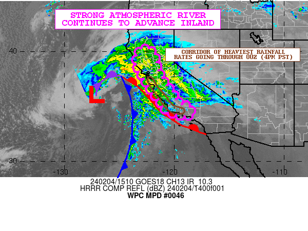
Image

MESOSCALE PRECIPITATION DISCUSSION 0046
NWS WEATHER PREDICTION CENTER COLLEGE PARK MD
1023 AM EST SUN FEB 25 2018

AREAS AFFECTED...SOUTHEAST TX INTO CENTRAL LA

CONCERNING...HEAVY RAINFALL...FLASH FLOODING POSSIBLE

VALID 251520Z - 252120Z

SUMMARY...HEAVY RAINFALL MAY CAUSE SOME RUNOFF PROBLEMS AND
CONCERNS FOR FLASH FLOODING GOING THROUGH THE MID-AFTERNOON HOURS.

DISCUSSION...A WELL-DEFINED SHORTWAVE IMPULSE IS SEEN IN THE
GOES-16 7.3/MICRON WV IMAGERY LIFTING NORTHEAST ACROSS THE
SOUTHEAST TX COASTAL PLAIN. THIS IS INTERACTING WITH A
QUASI-STATIONARY FRONTAL ZONE NEAR THE COAST AND IS FOSTERING AN
EXPANSION OF CONVECTION ACROSS SOUTHEAST TX AND INTO PORTIONS OF
WEST-CENTRAL LA. MOISTURE IS RATHER WELL ESTABLISHED ACROSS THE
REGION WITH PWATS OF 1.5 TO 1.75 INCHES. THIS AGAIN INCLUDES A
CONTRIBUTION IN THE MID AND HIGH LEVELS FROM DEEP LAYER SOUTHWEST
FLOW LIFTING UP FROM THE EASTERN TROPICAL PACIFIC. INSTABILITY
PROFILES ARE RELATIVELY MODEST OVER SOUTHEAST TX...BUT THERE IS A
POOL OF MUCAPE VALUES OF AS MUCH AS 1000+ J/KG POOLED ALONG THE
SOUTHWESTERN TAIL OF THE FRONT. GIVEN THE SHORTWAVE DYNAMICS AND
MOISTURE/INSTABILITY TRANSPORT UP OVER THE FRONT AHEAD OF THE
WAVE...THE CONVECTION HAS BEEN DEVELOPING AND GAINING SOME
ORGANIZATION WITHOUT ISSUE THIS MORNING.

THE LAST COUPLE RUNS OF THE HRRR AND THE OVERNIGHT CAM GUIDANCE
CONTINUES TO SUGGEST THIS WAVE LIFTING NORTHEAST INTO
CENTRAL/NORTHERN LA THROUGH EARLY TO MID AFTERNOON...AND SO THE
STRONGEST CONVECTIVE THREAT WILL BE OVER SOUTHEAST TX INITIALLY
AND THEN BEGIN TO FOCUS MORE INTO WESTERN/CENTRAL LA WITH TIME AS
GREATER MOISTURE AND ELEVATED INSTABILITY TRANSPORT OCCURS HERE IN
PROXIMITY TO THE FRONT.

ALREADY LOCAL RADARS AND SURFACE OBSERVATIONS ARE INDICATING
RAINFALL RATES OF 1.5 TO 2 INCHES/HR...AND WITH SOME PERIODIC
REPEATING/TRAINING NATURE OF THE ACTIVITY THERE WILL BE SOME
ADDITIONAL TOTALS THAT COULD REACH UP INTO THE 2 TO 3 INCH RANGE
WITH ISOLATED HEAVIER AMOUNTS THROUGH MIDDAY AFTERNOON. WILL
CONTINUE TO MONITOR.

SOIL CONDITIONS ARE RATHER MOIST OVERALL AND SO THE ADDITIONAL
RAINS TODAY WILL INCREASE THE CONCERN FOR RUNOFF PROBLEMS AND
PERHAPS SOME AREAS OF FLASH FLOODING WHERE STRONGER CONVECTIVE
CORES FOCUS AND THEN PERHAPS REPEAT OVER THE SAME AREA.

ORRISON

ATTN...WFO...EWX...FWD...HGX...JAN...LCH...SHV...

ATTN...RFC...LMRFC...WGRFC...

LAT...LON 32089285 31979213 31639179 31019181 30499239
30239334 29939477 29529593 29369673 29729743
30349762 31039736 31639579 31849445
0 likes   
Contract Meteorologist. TAMU & MSST. Fiercely authentic, one of a kind. We are all given free will, so choose a life meant to be lived. We are the Masters of our own Stories.
Opinions expressed are mine alone.

Follow me on Twitter at @1900hurricane : Read blogs at https://1900hurricane.wordpress.com/

User avatar
1900hurricane
Category 5
Category 5
Posts: 6044
Age: 33
Joined: Fri Feb 06, 2015 12:04 pm
Location: Houston, TX
Contact:

Re: Texas Winter 2017-2018

#9197 Postby 1900hurricane » Sun Feb 25, 2018 11:00 am

The streamer showers actually appear to be developing on the leading edge of the surface cold front. This is supported by obs of 75ºF at Angleton and 58ºF at Hobby Airport.
0 likes   
Contract Meteorologist. TAMU & MSST. Fiercely authentic, one of a kind. We are all given free will, so choose a life meant to be lived. We are the Masters of our own Stories.
Opinions expressed are mine alone.

Follow me on Twitter at @1900hurricane : Read blogs at https://1900hurricane.wordpress.com/

User avatar
1900hurricane
Category 5
Category 5
Posts: 6044
Age: 33
Joined: Fri Feb 06, 2015 12:04 pm
Location: Houston, TX
Contact:

Re: Texas Winter 2017-2018

#9198 Postby 1900hurricane » Sun Feb 25, 2018 11:07 am

KDPs do appear to be weakening some though. It might just be temporary, but I suspect it may be due to the mid-level impulse beginning to pull away.

Image
0 likes   
Contract Meteorologist. TAMU & MSST. Fiercely authentic, one of a kind. We are all given free will, so choose a life meant to be lived. We are the Masters of our own Stories.
Opinions expressed are mine alone.

Follow me on Twitter at @1900hurricane : Read blogs at https://1900hurricane.wordpress.com/

User avatar
Haris
Category 5
Category 5
Posts: 1808
Joined: Mon Nov 27, 2017 8:19 pm
Location: ( Bee Cave) West Austin, Texas

Re: Texas Winter 2017-2018

#9199 Postby Haris » Sun Feb 25, 2018 11:19 am

Folks from Round Rock to Lakeway??

Training stormms N&W of Austin all morning, ive recorded near 1/2" . Surprise rain again LOL
2 likes   
Weather geek and a storm spotter in West Austin. Not a degreed meteorologist. Big snow fan. Love rain and cold! Despise heat!

User avatar
bubba hotep
S2K Supporter
S2K Supporter
Posts: 5495
Joined: Wed Dec 28, 2016 1:00 am
Location: Collin County Texas

Re: Texas Winter 2017-2018

#9200 Postby bubba hotep » Sun Feb 25, 2018 12:00 pm

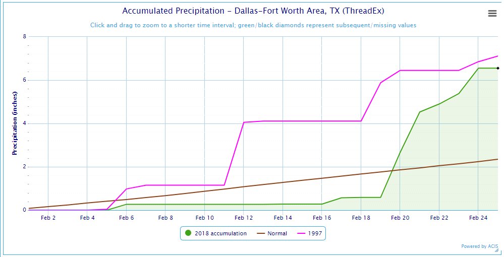
DFW gets a couple of days to dry out before another round of wet weather moves in with the potential for heavy rain and svr storms. It looks like portions of DFW could pick up another 2-4" of rain before we close out February. DFW is now 4.32" above normal for Feb, 5.05" above for winter, and within striking distance of the Feb record! The airport has just missed blowing out the record with reports in surrounding areas already topping 10". An interesting tidbit, it looks like DFW almost always has an above avg rainfall year when going over 6" in Feb.

Image

Image
0 likes   
Winter time post are almost exclusively focused on the DFW area.


Return to “Winter Weather”

Who is online

Users browsing this forum: No registered users and 176 guests