Texas Winter 2017-2018

Winter Weather Discussion

Moderator: S2k Moderators

Forum rules

The posts in this forum are NOT official forecast and should not be used as such. They are just the opinion of the poster and may or may not be backed by sound meteorological data. They are NOT endorsed by any professional institution or STORM2K.

Help Support Storm2K
Message
Author
User avatar
ThunderSleetDreams
S2K Supporter
S2K Supporter
Posts: 1398
Age: 41
Joined: Tue Dec 20, 2011 4:42 pm
Location: S of Weimar, TX

Re: Texas Winter 2017-2018

#6941 Postby ThunderSleetDreams » Sun Jan 21, 2018 1:11 pm

Portastorm wrote:Let's see ...

Cross-polar flow: check

Cold trough over the middle of the CONUS: check

Upper level energy to the southwest of Texas: check

What's not to like here?!

https://s17.postimg.org/4obv2b1vz/Model_viewer_-_Mozilla_Firefox_2018-01-21_10.05.55.png


Winter lovers pornography
3 likes   
#NeverSummer

I hibernate when it gets above 75 degrees!

Ntxw
Storm2k Moderator
Storm2k Moderator
Posts: 21501
Joined: Wed Oct 21, 2009 6:34 pm
Location: DFW, Texas

Re: Texas Winter 2017-2018

#6942 Postby Ntxw » Sun Jan 21, 2018 1:59 pm

Still long range language but...

Curious to see what some ENS members may show cold wise this week

Image
0 likes   
The above post and any post by Ntxw is NOT an official forecast and should not be used as such. It is just the opinion of the poster and may or may not be backed by sound meteorological data. It is NOT endorsed by any professional institution including Storm2k. For official information, please refer to NWS products.

  Help support Storm2K!
Help Support Storm2K

User avatar
TeamPlayersBlue
Category 5
Category 5
Posts: 3307
Joined: Tue Feb 02, 2010 1:44 am
Location: Denver/Applewood, CO

Re: Texas Winter 2017-2018

#6943 Postby TeamPlayersBlue » Sun Jan 21, 2018 2:32 pm

Holy moly. Last couple runs on GFS are interesting.

I've been stepping out there and saying to my friends that here in SE TX, we will have one more winter weather event. First we need the cold....
0 likes   
Personal Forecast Disclaimer:
The posts in this forum are NOT official forecast and should not be used as such. They are just the opinion of the poster and may or may not be backed by sound meteorological data. They are NOT endorsed by any professional institution or storm2k.org. For official information, please refer to the NHC and NWS products.

User avatar
EnnisTx
S2K Supporter
S2K Supporter
Posts: 896
Joined: Sat Dec 26, 2015 4:06 pm
Location: Albany, Texas
Contact:

Re: Texas Winter 2017-2018

#6944 Postby EnnisTx » Sun Jan 21, 2018 3:10 pm

Won’t be surprised to see a tornado watch soon from the metroplex into East Texas.
0 likes   

User avatar
gboudx
S2K Supporter
S2K Supporter
Posts: 4047
Joined: Thu Sep 04, 2003 1:39 pm
Location: Rockwall, Tx but from Harvey, La

Re: Texas Winter 2017-2018

#6945 Postby gboudx » Sun Jan 21, 2018 3:25 pm

Pouring here in Rockwall, with some thunder too. Made the DirecTV feed go out.
0 likes   

User avatar
bubba hotep
S2K Supporter
S2K Supporter
Posts: 5456
Joined: Wed Dec 28, 2016 1:00 am
Location: Collin County Texas

Re: Texas Winter 2017-2018

#6946 Postby bubba hotep » Sun Jan 21, 2018 3:48 pm

Image

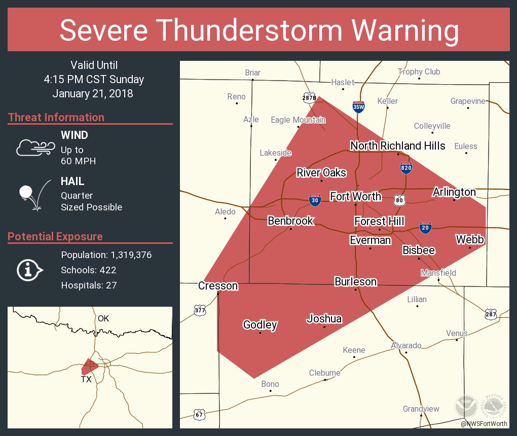
Mesoscale Discussion 0032
NWS Storm Prediction Center Norman OK
0113 PM CST Sun Jan 21 2018

Areas affected...northeast Texas...eastern Oklahoma through western
Arkansas

Concerning...Severe potential...Tornado Watch likely

Valid 211913Z - 212115Z

Probability of Watch Issuance...80 percent

SUMMARY...Thunderstorms are expected to develop by 21Z across
northeast Texas into eastern Oklahoma and subsequently increase in
coverage and intensity. Supercells and bowing line segments with
damaging wind and a few tornadoes should be the primary threats. A
tornado watch will probably be needed before 21Z.

DISCUSSION...This afternoon a dryline extends from northeast KS
through west-central OK to north-central and southwest TX. Pacific
front will merge with the dryline later this afternoon, and this
boundary will continue through the southern Plains this evening as a
surface low consolidates over eastern KS in association with a
progressive shortwave trough. Modifying continental-polar air with
low 60s F dewpoints has advected through the warm sector beneath
modest lapse rates where objective analysis shows a corridor of
500-800 J/KG MLCAPE from central and northeast TX into southeast OK.
WV imagery indicates mid-upper level moistening and clouds resulting
from a band of deeper forcing for ascent moving through eastern OK
and northeast TX, and scattered showers are already developing over
northeast TX in association with this process. RAP soundings
indicate a capping inversion still in place around 750 mb, but
ascent in the 850-500 mb layer layer will eventually erode the
inversion, contributing to thunderstorm development by 20-21Z.
Vertical wind shear will increase as the low-level jet strengthens
within exit region of the approaching mid-upper jet with large 0-1
km hodographs and effective-bulk shear exceeding 40 kt. This
environment should support organized storms including a few discrete
supercells and bowing line segments as storms intensify later this
afternoon and evening.

..Dial/Grams.. 01/21/2018
0 likes   
Winter time post are almost exclusively focused on the DFW area.

User avatar
gboudx
S2K Supporter
S2K Supporter
Posts: 4047
Joined: Thu Sep 04, 2003 1:39 pm
Location: Rockwall, Tx but from Harvey, La

Re: Texas Winter 2017-2018

#6947 Postby gboudx » Sun Jan 21, 2018 3:53 pm

Pea-sized hail too. My neighbors weather station shows 0.97" so far.
3 likes   

User avatar
cycloneye
Admin
Admin
Posts: 139062
Age: 67
Joined: Thu Oct 10, 2002 10:54 am
Location: San Juan, Puerto Rico

Re: Texas Winter 2017-2018

#6948 Postby cycloneye » Sun Jan 21, 2018 4:16 pm

0 likes   
Visit the Caribbean-Central America Weather Thread where you can find at first post web cams,radars
and observations from Caribbean basin members Click Here

aggiecutter
Category 5
Category 5
Posts: 1743
Joined: Thu Oct 14, 2004 9:22 pm
Location: Texarkana

Re: Texas Winter 2017-2018

#6949 Postby aggiecutter » Sun Jan 21, 2018 4:27 pm

TORNADO WATCH OUTLINE UPDATE FOR WT 1
NWS STORM PREDICTION CENTER NORMAN OK
305 PM CST SUN JAN 21 2018

TORNADO WATCH 1 IS IN EFFECT UNTIL 1100 PM CST FOR THE
FOLLOWING LOCATIONS

TXC001-037-063-067-073-119-147-159-161-183-203-213-223-231-257-
277-315-343-349-365-379-387-401-423-449-459-467-499-220500-
/O.NEW.KWNS.TO.A.0001.180121T2105Z-180122T0500Z/

TX
. TEXAS COUNTIES INCLUDED ARE

ANDERSON BOWIE CAMP
CASS CHEROKEE DELTA
FANNIN FRANKLIN FREESTONE
GREGG HARRISON HENDERSON
HOPKINS HUNT KAUFMAN
LAMAR MARION MORRIS
NAVARRO PANOLA RAINS
RED RIVER RUSK SMITH
TITUS UPSHUR VAN ZANDT
WOOD
$$
0 likes   

User avatar
bubba hotep
S2K Supporter
S2K Supporter
Posts: 5456
Joined: Wed Dec 28, 2016 1:00 am
Location: Collin County Texas

Re: Texas Winter 2017-2018

#6950 Postby bubba hotep » Sun Jan 21, 2018 4:40 pm

First svr warned cell is outside the watch box, have to watch that broken line of cells for spin ups as they move across the metroplex.

Image
0 likes   
Winter time post are almost exclusively focused on the DFW area.

User avatar
bubba hotep
S2K Supporter
S2K Supporter
Posts: 5456
Joined: Wed Dec 28, 2016 1:00 am
Location: Collin County Texas

Re: Texas Winter 2017-2018

#6951 Postby bubba hotep » Sun Jan 21, 2018 4:51 pm

Line is coming together pretty quickly, this should give the airport a nice downpour.

Image
1 likes   
Winter time post are almost exclusively focused on the DFW area.

gpsnowman
S2K Supporter
S2K Supporter
Posts: 2713
Joined: Fri Jan 07, 2011 10:35 am
Location: Grand Prairie Tx

Re: Texas Winter 2017-2018

#6952 Postby gpsnowman » Sun Jan 21, 2018 4:54 pm

:uarrow: Nice line heading this way. I am a little concerned though, my wife is on a plane near Austin and I just noticed on Flightaware that her plane has turned northwest away from the line of storms. Delayed soon I am sure. The flight path was directly through the line.
Edit: Her flight was diverted to Austin.
0 likes   

User avatar
EnnisTx
S2K Supporter
S2K Supporter
Posts: 896
Joined: Sat Dec 26, 2015 4:06 pm
Location: Albany, Texas
Contact:

Re: Texas Winter 2017-2018

#6953 Postby EnnisTx » Sun Jan 21, 2018 5:12 pm

bubba hotep wrote:First svr warned cell is outside the watch box, have to watch that broken line of cells for spin ups as they move across the metroplex.

Image


Yep, getting dark here. First time I've heard thunder in a good while!
0 likes   

User avatar
EnnisTx
S2K Supporter
S2K Supporter
Posts: 896
Joined: Sat Dec 26, 2015 4:06 pm
Location: Albany, Texas
Contact:

Re: Texas Winter 2017-2018

#6954 Postby EnnisTx » Sun Jan 21, 2018 5:22 pm

Pouring down rain here! :raincloud:
1 likes   

User avatar
Portastorm
Storm2k Moderator
Storm2k Moderator
Posts: 9787
Age: 61
Joined: Fri Jul 11, 2003 9:16 am
Location: South Austin, TX
Contact:

Re: Texas Winter 2017-2018

#6955 Postby Portastorm » Sun Jan 21, 2018 5:38 pm

gpsnowman wrote::uarrow: Nice line heading this way. I am a little concerned though, my wife is on a plane near Austin and I just noticed on Flightaware that her plane has turned northwest away from the line of storms. Delayed soon I am sure. The flight path was directly through the line.
Edit: Her flight was diverted to Austin.


There are much worse airports to get diverted to than Austin. :wink:

She’ll be fine. Have her get a bbq plate at Salt Lick.
6 likes   
Any forecasts under my name are to be taken with a grain of salt. Get your best forecasts from the National Weather Service and National Hurricane Center.

I'm a certified Advanced SKYWARN-trained spotter and am active on Twitter at @TravisCOSW, a social media partner of the NWS Austin-San Antonio office.

User avatar
EnnisTx
S2K Supporter
S2K Supporter
Posts: 896
Joined: Sat Dec 26, 2015 4:06 pm
Location: Albany, Texas
Contact:

Re: Texas Winter 2017-2018

#6956 Postby EnnisTx » Sun Jan 21, 2018 5:40 pm

EnnisTx wrote:Pouring down rain here! :raincloud:


Wow! Heavy rain with the gutters overflowing, first time I've seen that here. A quick 1.10" wind driven downpour and it's not done yet, starting to pick up again.
1 likes   

Ralph's Weather
S2K Supporter
S2K Supporter
Posts: 2968
Age: 36
Joined: Fri Dec 13, 2013 11:55 am
Location: Lindale, TX

Re: Texas Winter 2017-2018

#6957 Postby Ralph's Weather » Sun Jan 21, 2018 5:44 pm

Tornado warning for Lamar Co.
1 likes   
Follow on Facebook at Ralph's Weather.

User avatar
EnnisTx
S2K Supporter
S2K Supporter
Posts: 896
Joined: Sat Dec 26, 2015 4:06 pm
Location: Albany, Texas
Contact:

Re: Texas Winter 2017-2018

#6958 Postby EnnisTx » Sun Jan 21, 2018 5:44 pm

First tornado warning Northeast of Paris. Lamar County.
0 likes   

gpsnowman
S2K Supporter
S2K Supporter
Posts: 2713
Joined: Fri Jan 07, 2011 10:35 am
Location: Grand Prairie Tx

Re: Texas Winter 2017-2018

#6959 Postby gpsnowman » Sun Jan 21, 2018 5:45 pm

Portastorm wrote:
gpsnowman wrote::uarrow: Nice line heading this way. I am a little concerned though, my wife is on a plane near Austin and I just noticed on Flightaware that her plane has turned northwest away from the line of storms. Delayed soon I am sure. The flight path was directly through the line.
Edit: Her flight was diverted to Austin.


There are much worse airports to get diverted to than Austin. :wink:

She’ll be fine. Have her get a bbq plate at Salt Lick.

Thanks Porta. She landed and called me from the runway. They are thinking about an hour before taking off again. At least that is the plan now.
0 likes   

gpsnowman
S2K Supporter
S2K Supporter
Posts: 2713
Joined: Fri Jan 07, 2011 10:35 am
Location: Grand Prairie Tx

Re: Texas Winter 2017-2018

#6960 Postby gpsnowman » Sun Jan 21, 2018 5:52 pm

Heavy rain here with crazy hail!!!!!
2 likes   


Return to “Winter Weather”

Who is online

Users browsing this forum: No registered users and 208 guests