Texas Winter 2018-2019
Moderator: S2k Moderators
Forum rules
 The posts in this forum are NOT official forecast and should not be used as such. They are just the opinion of the poster and may or may not be backed by sound meteorological data. They are NOT endorsed by any professional institution or STORM2K.

The posts in this forum are NOT official forecast and should not be used as such. They are just the opinion of the poster and may or may not be backed by sound meteorological data. They are NOT endorsed by any professional institution or STORM2K.
-
bubba hotep

- S2K Supporter

- Posts: 5453
- Joined: Wed Dec 28, 2016 1:00 am
- Location: Collin County Texas
Re: Texas Winter 2018-2019
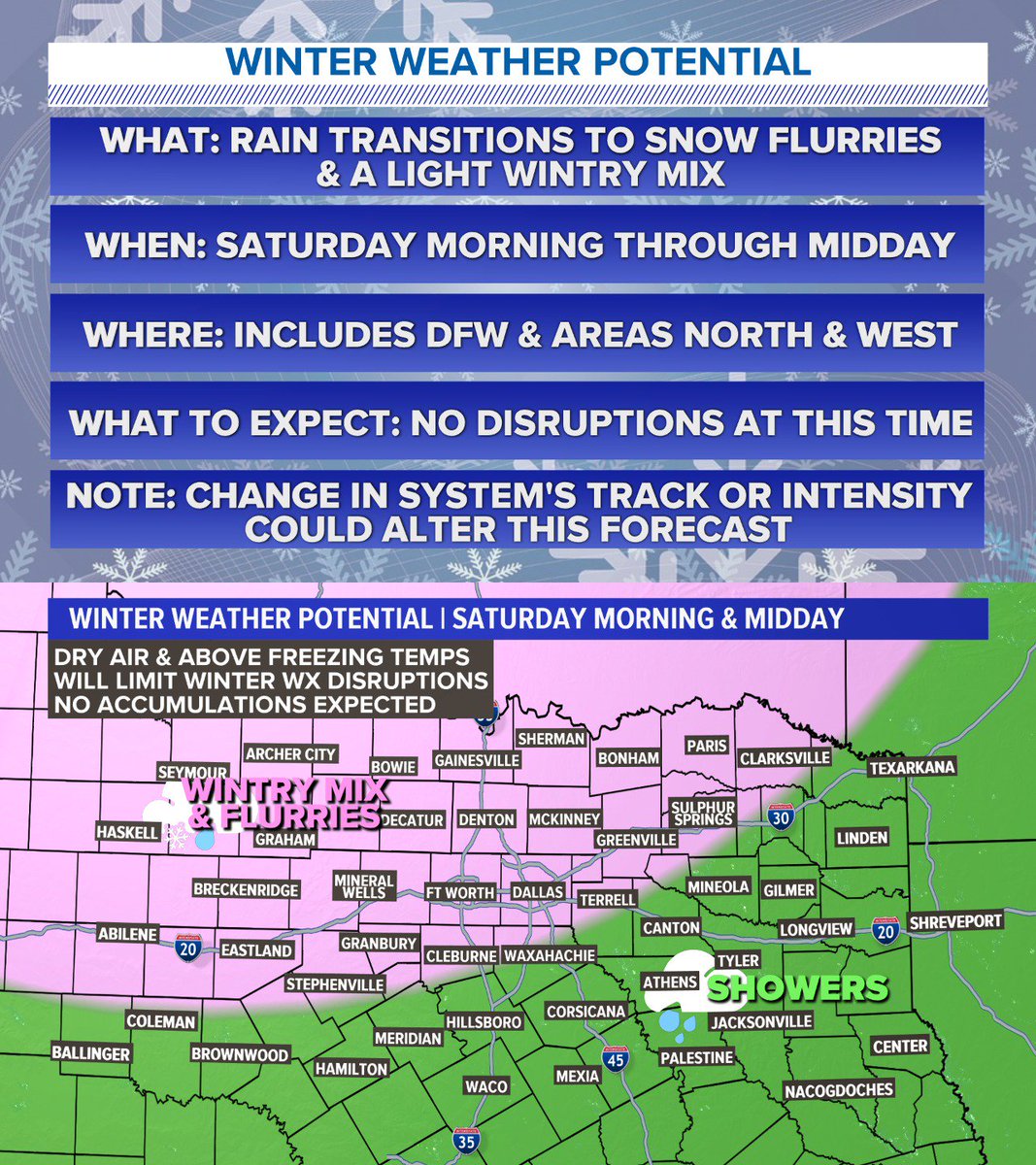
Both the 18z GEFS and 21z SREF throw up zeros for DFW snow totals with the weekend system.
0 likes
Winter time post are almost exclusively focused on the DFW area.
-
starsfan65

- Category 2

- Posts: 675
- Age: 46
- Joined: Thu Dec 17, 2015 1:18 pm
- Location: Garland,Tx
Re: Texas Winter 2018-2019
zeros?bubba hotep wrote:Both the 18z GEFS and 21z SREF throw up zeros for DFW snow totals with the weekend system.
0 likes

Re: Texas Winter 2018-2019
If there are a lot of newbies around, perhaps a discussion about the 540 line and 850 mb temps is in order.
5 likes

Re: Texas Winter 2018-2019
Quixotic wrote:If there are a lot of newbies around, perhaps a discussion about the 540 line and 850 mb temps is in order.
That would be beneficial to me. I’m an aspiring meteorologist but I have zero experience and I’m using this forum (and other resources) to gain exposure to meteorology.
1 likes
Undergraduate Meteorology Student at the University of Oklahoma and Operator at the Oklahoma Mesonet.
All opinions independent of employers and the university.
All opinions independent of employers and the university.
-
bubba hotep
- S2K Supporter
- Posts: 5453
- Joined: Wed Dec 28, 2016 1:00 am
- Location: Collin County Texas
Re: Texas Winter 2018-2019
starsfan65 wrote:zeros?bubba hotep wrote:Both the 18z GEFS and 21z SREF throw up zeros for DFW snow totals with the weekend system.
As in, zero inches of snow.
1 likes
Winter time post are almost exclusively focused on the DFW area.
-
Brent
- S2K Supporter
- Posts: 37086
- Age: 35
- Joined: Sun May 16, 2004 10:30 pm
- Location: Tulsa Oklahoma
- Contact:
Re: Texas Winter 2018-2019
bubba hotep wrote:starsfan65 wrote:zeros?bubba hotep wrote:Both the 18z GEFS and 21z SREF throw up zeros for DFW snow totals with the weekend system.
As in, zero inches of snow.
basically the last almost 4 years in DFW
2 likes
#neversummer
-
bubba hotep
- S2K Supporter
- Posts: 5453
- Joined: Wed Dec 28, 2016 1:00 am
- Location: Collin County Texas
Re: Texas Winter 2018-2019
Quixotic wrote:If there are a lot of newbies around, perhaps a discussion about the 540 line and 850 mb temps is in order.
Its funny, before model soundings were widely available the 540 and 850 lines were gospel on wx forums and blogs (circa my DC days).
3 likes
Winter time post are almost exclusively focused on the DFW area.
Re: Texas Winter 2018-2019
bubba hotep wrote:Both the 18z GEFS and 21z SREF throw up zeros for DFW snow totals with the weekend system.
This is a harbinger of things to come. The second and third systems are what I’m watching. These borderline systems mean we are on the front and eventually, we will win the battle.
2 likes
-
bubba hotep
- S2K Supporter
- Posts: 5453
- Joined: Wed Dec 28, 2016 1:00 am
- Location: Collin County Texas
Re: Texas Winter 2018-2019
Delkus with an update.
2 likes
Winter time post are almost exclusively focused on the DFW area.

Re: Texas Winter 2018-2019
Quixotic wrote:bubba hotep wrote:Both the 18z GEFS and 21z SREF throw up zeros for DFW snow totals with the weekend system.
This is a harbinger of things to come. The second and third systems are what I’m watching. These borderline systems mean we are on the front and eventually, we will win the battle.
I was encouraged about the system next Wednesday, but I'm worried about "glancing blows".

4 likes
The above post and any post by dhweather is NOT an official forecast and should not be used as such. It is just the opinion of the poster and may or may not be backed by sound meteorological data. It is NOT endorsed by any professional institution including storm2k.org. For official information, please refer to NWS products.
Re: Texas Winter 2018-2019
The image isn't showing up ??
0 likes
The above post and any post by dhweather is NOT an official forecast and should not be used as such. It is just the opinion of the poster and may or may not be backed by sound meteorological data. It is NOT endorsed by any professional institution including storm2k.org. For official information, please refer to NWS products.
-
Brent
- S2K Supporter
- Posts: 37086
- Age: 35
- Joined: Sun May 16, 2004 10:30 pm
- Location: Tulsa Oklahoma
- Contact:
Re: Texas Winter 2018-2019
dhweather wrote:Quixotic wrote:bubba hotep wrote:Both the 18z GEFS and 21z SREF throw up zeros for DFW snow totals with the weekend system.
or
This is a harbinger of things to come. The second and third systems are what I’m watching. These borderline systems mean we are on the front and eventually, we will win the battle.
I was encouraged about the system next Wednesday, but I'm worried about "glancing blows".
yeah to me the Wednesday storm has far more potential but its in that stupid range zero has worked in our favor so far
The NAM is ugly for the weekend no snow(and its too warm during the day Saturday anyway to matter) and DFW is only at 30 Sunday morning zzzz
Last edited by Brent on Wed Jan 16, 2019 9:53 pm, edited 1 time in total.
1 likes
#neversummer

Re: Texas Winter 2018-2019
For those wanting to throw in the towel let me use a quote from the great ESPN Game Day Lee Corso "Not so fast my friends" We still have plenty of things on our side! Today's 12z Euro is one of them which still shows a Potential Winter Storm be it Snow and or Ice for early next week.. GFS FV3 has been sending ON AND OFF weak signals as well! Just because the runs are all of the place doesn't mean we need to go into all out panic mode! that's what models do I understand it's confusing as heck for the general public and frustrating for us forecasters but trust me the pattern we are getting into is much more favorable for a Winter Storm or two... So let's all calm down and sit back and enjoy the ride!
10 likes
-
Haris

- Category 5

- Posts: 1808
- Joined: Mon Nov 27, 2017 8:19 pm
- Location: ( Bee Cave) West Austin, Texas
Re: Texas Winter 2018-2019


Off the topic but I have seen so many TV mets for the sake of oversimplifying things call this upper low the snowmaker for the weekend across the midwest and NE.
If you look at vort, its the seed S of Alaska that undercuts it....
The low is moving N!
1 likes
Weather geek and a storm spotter in West Austin. Not a degreed meteorologist. Big snow fan. Love rain and cold! Despise heat!
Re: Texas Winter 2018-2019
Haris wrote:[url]https://i.ibb.co/k0ChrrV/Screenshot-at-Jan-16-20-40-57.png [/url]
[url]https://i.ibb.co/1Q4mfdv/Screenshot-at-Jan-16-20-40-22.png [/url]
Off the topic but I have seen so many TV mets for the sake of oversimplifying things call this upper low the snowmaker for the weekend across the midwest and NE.
If you look at vort, its the seed S of Alaska that undercuts it....
The low is moving N!
Steve McCauley mentions this exactly on his recent FB post. A southern portion of the main storm slamming the Pacific Coast is what will bring us our little storm Friday into Saturday. Weird, weather is truly fascinating.
0 likes
-
Texas Snow

- S2K Supporter
- Posts: 730
- Joined: Mon Oct 19, 2015 12:06 pm
- Location: N. Dallas & Cedar Creek Lake
Re: Texas Winter 2018-2019
OKMet83 wrote:For those wanting to throw in the towel let me use a quote from the great ESPN Game Day Lee Corso "Not so fast my friends" We still have plenty of things on our side! Today's 12z Euro is one of them which still shows a Potential Winter Storm be it Snow and or Ice for early next week.. GFS FV3 has been sending ON AND OFF weak signals as well! Just because the runs are all of the place doesn't mean we need to go into all out panic mode! that's what models do I understand it's confusing as heck for the general public and frustrating for us forecasters but trust me the pattern we are getting into is much more favorable for a Winter Storm or two... So let's all calm down and sit back and enjoy the ride!
Preach Brother Okie!
1 likes
"Don't let wishcastin get in the way of your forecastin"

-
bubba hotep
- S2K Supporter
- Posts: 5453
- Joined: Wed Dec 28, 2016 1:00 am
- Location: Collin County Texas
Re: Texas Winter 2018-2019
Haris wrote:[url]https://i.ibb.co/k0ChrrV/Screenshot-at-Jan-16-20-40-57.png [/url]
[url]https://i.ibb.co/1Q4mfdv/Screenshot-at-Jan-16-20-40-22.png [/url]
Off the topic but I have seen so many TV mets for the sake of oversimplifying things call this upper low the snowmaker for the weekend across the midwest and NE.
If you look at vort, its the seed S of Alaska that undercuts it....
The low is moving N!
It is occluded and dissipates into the shortwave as it moves on shore, not so much moving north.

1 likes
Winter time post are almost exclusively focused on the DFW area.
Re: Texas Winter 2018-2019
Cerlin wrote:Quixotic wrote:If there are a lot of newbies around, perhaps a discussion about the 540 line and 850 mb temps is in order.
That would be beneficial to me. I’m an aspiring meteorologist but I have zero experience and I’m using this forum (and other resources) to gain exposure to meteorology.
Great honesty. You’re golden.
540 line and the 850 0 line are basically demarcations of snow. If the 540 line (upper level) is over or south of your area, Snow is possible. 850 0 line is indicative of wwx. If you have the combo, well, hip hiop hooray. As bubbahotep pointed out though, soundings ( which indicate temps, dewpoints and winds throughout the atmosphere) are a better indicator. If you get used to this basic concept: progress by calculating thicknesses. That’s when you really have a grasp on what will happen. I’ve seen rain at 20F. I’ve seen snow at 50F. Keep that layer in mind and you’ll be good. Smarter people than me can explain it. I’m just bad at jargon. Best of luck to you.
3 likes
-
rwfromkansas
- Category 5
- Posts: 2160
- Joined: Sat Aug 27, 2005 12:47 am
- Location: North Fort Worth
Re: Texas Winter 2018-2019
One nice thing about West Texas was that you didn't really need the 540 line for snow. 546 often did it. There's still a lot I don't know. I have the Tim Vasquez forecasting book, but I need to read it when I can really focus. lol
2 likes
-
Lagreeneyes03
- Category 1

- Posts: 476
- Joined: Mon Dec 09, 2013 10:53 am
- Location: Luxurious Lake Grapevine
Re: Texas Winter 2018-2019
Haris wrote:[url]https://i.ibb.co/k0ChrrV/Screenshot-at-Jan-16-20-40-57.png [/url]
[url]https://i.ibb.co/1Q4mfdv/Screenshot-at-Jan-16-20-40-22.png [/url]
Off the topic but I have seen so many TV mets for the sake of oversimplifying things call this upper low the snowmaker for the weekend across the midwest and NE.
If you look at vort, its the seed S of Alaska that undercuts it....
The low is moving N!
Do we want it to move N? I always thought if the L was south of the 'Plex, we got winter weather. If not, "Cold Rain".
0 likes
I'm a Princess, not a forecaster.
Who is online
Users browsing this forum: No registered users and 78 guests