
ENSO Updates (2007 thru 2023)
Moderator: S2k Moderators
Forum rules

The posts in this forum are NOT official forecasts and should not be used as such. They are just the opinion of the poster and may or may not be backed by sound meteorological data. They are NOT endorsed by any professional institution or STORM2K. For official information, please refer to products from the National Hurricane Center and National Weather Service.
-
cycloneye

- Admin

- Posts: 139080
- Age: 67
- Joined: Thu Oct 10, 2002 10:54 am
- Location: San Juan, Puerto Rico
Re: ENSO Updates: PDO goes up to +1.72
ECMWF joins CFSv2 on the uptick but there is the spring barrier that we have to see how the models perform so I wouldn't jump to a conclusion on how strong and how long in time El Nino will be.
0 likes
Visit the Caribbean-Central America Weather Thread where you can find at first post web cams,radars
and observations from Caribbean basin members Click Here
and observations from Caribbean basin members Click Here

Re: ENSO Updates: PDO goes up to +1.72
cycloneye wrote:ECMWF joins CFSv2 on the uptick but there is the spring barrier that we have to see how the models perform so I wouldn't jump to a conclusion on how strong and how long in time El Nino will be.
I heard the spring barrier is the part of the year where forecasting an el nino is harder? I wonder why...
0 likes
Remember, all of my post aren't official. For official warnings and discussions, Please refer to your local NWS products...
NWS for the Western Pacific
https://www.weather.gov/gum/
NWS for the Western Pacific
https://www.weather.gov/gum/
-
cycloneye
- Admin
- Posts: 139080
- Age: 67
- Joined: Thu Oct 10, 2002 10:54 am
- Location: San Juan, Puerto Rico
Re: ENSO Updates: PDO goes up to +1.72
euro6208 wrote:cycloneye wrote:ECMWF joins CFSv2 on the uptick but there is the spring barrier that we have to see how the models perform so I wouldn't jump to a conclusion on how strong and how long in time El Nino will be.
I heard the spring barrier is the part of the year where forecasting an el nino is harder? I wonder why...
Here is a technical explanation about the Spring Barrier.
http://link.springer.com/article/10.100 ... 012-1271-z
0 likes
Visit the Caribbean-Central America Weather Thread where you can find at first post web cams,radars
and observations from Caribbean basin members Click Here
and observations from Caribbean basin members Click Here
-
Kingarabian

- S2K Supporter

- Posts: 15434
- Joined: Sat Aug 08, 2009 3:06 am
- Location: Honolulu, Hawaii
-
cycloneye
- Admin
- Posts: 139080
- Age: 67
- Joined: Thu Oct 10, 2002 10:54 am
- Location: San Juan, Puerto Rico
Re: ENSO Updates
Not as large as the pool of March/April but neverless the present warm pool is fairly warm at sub-surface .


0 likes
Visit the Caribbean-Central America Weather Thread where you can find at first post web cams,radars
and observations from Caribbean basin members Click Here
and observations from Caribbean basin members Click Here
-
cycloneye
- Admin
- Posts: 139080
- Age: 67
- Joined: Thu Oct 10, 2002 10:54 am
- Location: San Juan, Puerto Rico
Re: CPC 12/18/14 update is up with graphic of plume of models
Climate Prediction Center 12/18/14 update
They say a moderate El Nino is not ruled out and there are still some things that are not El Nino-like.Read the whole update below along with the new updated graphic that has the plume of models.
IRI Technical ENSO Update
Published: December 18, 2014
Recent and Current Conditions
The SST anomaly in the NINO3.4 region has been at the weak El Niño level from mid-October to the present, and even reached the borderline of moderate El Niño for a single week at the end of November. For November the average NINO3.4 SST anomaly was 0.85 C, indicative of weak Niño conditions, and for Aug-Oct it was 0.60 C. The IRI’s definition of El Niño, like NOAA/Climate Prediction Center’s, requires that the SST anomaly in the Nino3.4 region (5S-5N; 170W-120W) exceed 0.5 C. Similarly, for La Niña, the anomaly must be -0.5 C or less. The climatological probabilities for La Niña, neutral, and El Niño conditions vary seasonally, and are shown in a table at the bottom of this page for each 3-month season. The most recent weekly SST anomaly in the Nino3.4 region was 0.9 C, in the category of weak El Niño for SST. However, accompanying this SST is an atmospheric pattern with inadequate indication of an El Niño-like pattern–very weak westerly low-level wind anomalies and no positive anomalies of convection near the dateline. Some indicators, however, such as the Southern Oscillation Index (SOI), have been somewhat indicative of weak El Niño, and the upper level wind anomalies are also showing El Niño-indicative enhanced easterlies.
Expected Conditions
What is the outlook for the ENSO status going forward? The most recent official diagnosis and outlook was issued earlier this month in the NOAA/Climate Prediction Center ENSO Diagnostic Discussion, produced jointly by CPC and IRI; it called for a 66% likelihood for El Niño conditions during the Nov-Jan season now in progress, remaining at 60% or more through Jan-Mar 2015. The latest set of model ENSO predictions, from mid-December, now available in the IRI/CPC ENSO prediction plume, is discussed below. Currently, Nino3.4 SST anomalies are about 0.9C, above the 0.5C threshold for weak El Niño. Subsurface temperature anomalies across the eastern equatorial Pacific have remained above average. In the atmosphere, the basin-wide sea level pressure pattern (e.g. the SOI) has been near the threshold of -0.8 to -0.10 for a weak El Niño in late November and early December, but recently weakened back toward neutral levels. Also, other atmospheric parameters continue to reflect neutral ENSO conditions: Weak anomalous low-level westerlies have only appeared at times during November and early December. Upper level anomalous easterly anomalies are being observed over substantial portions of the equatorial Pacific, indicative of El Niño. On the other hand, anomalous convection (as measured by OLR) has been near average, or even below average, near and eastward of the dateline. Together, the oceanic and atmospheric features currently reflect a warmish but neutral ENSO condition, despite the clearly weak El Niño status of the SST during the last one to two months.
As of mid-December, none of the dynamical or statistical models models predicts La Niña SST conditions for the initial Dec-Feb 2014-15 season, 96% predicts El Niño conditions, and 4% indicates neutral ENSO. At lead times of 3 or more months into the future, statistical and dynamical models that incorporate information about the ocean’s observed subsurface thermal structure generally exhibit higher predictive skill than those that do not. For the Mar-May 2015 season, among models that do use subsurface temperature information, 20% predicts ENSO-neutral SSTs, 80% predicts El Niño conditions and none predicts La Niña conditions. For all model types, the probability for neutral ENSO conditions is 32% or below between Dec-Feb 2014-15 through Apr-Jun 2015, and 50% or below through Jul-Sep. Probabilities for El Niño are 84% or higher between Dec-Feb 2014-15 and Jan-Mar, and at least 70% out to Apr-Jun 2015. No model predicts La Niña conditions for any of the 3-month periods between Dec-Feb 2014-15 and Aug-Oct 2015.
Note - Only models that produce a new ENSO prediction every month are included in the above statement.
Caution is advised in interpreting the distribution of model predictions as the actual probabilities. At longer leads, the skill of the models degrades, and skill uncertainty must be convolved with the uncertainties from initial conditions and differing model physics, leading to more climatological probabilities in the long-lead ENSO Outlook than might be suggested by the suite of models. Furthermore, the expected skill of one model versus another has not been established using uniform validation procedures, which may cause a difference in the true probability distribution from that taken verbatim from the raw model predictions.
An alternative way to assess the probabilities of the three possible ENSO conditions is more quantitatively precise and less vulnerable to sampling errors than the categorical tallying method used above. This alternative method uses the mean of the predictions of all models on the plume, equally weighted, and constructs a standard error function centered on that mean. The standard error is Gaussian in shape, and has its width determined by an estimate of overall expected model skill for the season of the year and the lead time. Higher skill results in a relatively narrower error distribution, while low skill results in an error distribution with width approaching that of the historical observed distribution. This method shows probabilities for La Niña near 0% from Dec-Feb 2014-15 through Apr-Jun 2015, rising to 5% by Jun-Aug and 14% by Aug-Oct. Model probabilities for neutral ENSO conditions are 17% for the initial period of Dec-Feb 2014-15, 24% for the next running period of Jan-Mar 2015, and rise to 39% by Apr-Jun, and to 40-45% for May-Jul through Aug-Oct. Probabilities for El Niño are 83% for Dec-Feb 2014-15, 76% for Jan-Mar 2015, 70% for Feb-Apr, and do not fall below 50% until Aug-Oct when they are 46%. The models collectively favor El Niño over other ENSO conditions by a sizable margin until Apr-Jun 2015. A plot of the probabilities generated from this most recent IRI/CPC ENSO prediction plume using the multi-model mean and the Gaussian standard error method summarizes the model consensus out to about 10 months into the future. The same cautions mentioned above for the distributional count of model predictions apply to this Gaussian standard error method of inferring probabilities, due to differing model biases and skills. In particular, this approach considers only the mean of the predictions, and not the total range across the models, nor the ensemble range within individual models.
The probabilities derived from the models on the IRI/CPC plume describe, on average, El Niño conditions for the Dec-Feb 2014-15 season currently in progress, enduring well into northern spring season of 2015. The consensus of model predictions calls for a weak El Niño event, although a moderate event cannot be ruled out. A strong event appears virtually impossible. A caution regarding this latest set of model-based ENSO plume predictions, is that factors such as known specific model biases and recent changes that the models may have missed will be taken into account in the next official outlook to be generated and issued in early October by CPC and IRI, which will include some human judgement in combination with the model guidance.
http://iri.columbia.edu/our-expertise/c ... o/current/
0 likes
Visit the Caribbean-Central America Weather Thread where you can find at first post web cams,radars
and observations from Caribbean basin members Click Here
and observations from Caribbean basin members Click Here
-
xtyphooncyclonex

- Category 5

- Posts: 3688
- Age: 22
- Joined: Sat Dec 08, 2012 9:07 am
- Location: Cebu City
- Contact:
It really appears that the CPC wants to be on the safe side, not wanting another bust from earlier this year. I'm thinking of this as a moderate Niño event.
0 likes
REMINDER: My opinions that I, or any other NON Pro-Met in this forum, are unofficial. Please do not take my opinions as an official forecast and warning. I am NOT a meteorologist. Following my forecasts blindly may lead to false alarm, danger and risk if official forecasts from agencies are ignored.

Re: CPC 12/18/14 update is up with ENSO models plume graphic
SST anomalies index looks like El Nino, but take a look at this:
https://twitter.com/WSI_Energy/status/5 ... 6393376768
https://twitter.com/WSI_Energy/status/5 ... 6393376768
0 likes
This post is NOT AN OFFICIAL FORECAST and should not be used as such. It is just the opinion of the poster and may or may not be backed by sound meteorological data. It is NOT endorsed by any professional institution including storm2k.org. For Official Information please refer to the NHC and NWS products.
-
cycloneye
- Admin
- Posts: 139080
- Age: 67
- Joined: Thu Oct 10, 2002 10:54 am
- Location: San Juan, Puerto Rico
Re: ENSO Updates
After all the hype of a Super El Nino WSI now comes with this?
0 likes
Visit the Caribbean-Central America Weather Thread where you can find at first post web cams,radars
and observations from Caribbean basin members Click Here
and observations from Caribbean basin members Click Here
-
cycloneye
- Admin
- Posts: 139080
- Age: 67
- Joined: Thu Oct 10, 2002 10:54 am
- Location: San Juan, Puerto Rico
Re: ENSO Updates: PDO goes up to +1.72
Kingarabian wrote:Still waiting.
Impressive PDO.
The new target date is January 8 when CPC will release their monthly diagonostic update. Let's see what happens then.
0 likes
Visit the Caribbean-Central America Weather Thread where you can find at first post web cams,radars
and observations from Caribbean basin members Click Here
and observations from Caribbean basin members Click Here
-
cycloneye
- Admin
- Posts: 139080
- Age: 67
- Joined: Thu Oct 10, 2002 10:54 am
- Location: San Juan, Puerto Rico
Re: ENSO Updates
That is one of the strongest Kelvin Waves I have seen.SOI is already responding.
SOI values for 20 Dec 2014
Average for last 30 days
-5.2
Average for last 90 days
-6.6
Daily contribution to SOI calculation
-16.0

SOI values for 20 Dec 2014
Average for last 30 days
-5.2
Average for last 90 days
-6.6
Daily contribution to SOI calculation
-16.0
0 likes
Visit the Caribbean-Central America Weather Thread where you can find at first post web cams,radars
and observations from Caribbean basin members Click Here
and observations from Caribbean basin members Click Here
-
cycloneye
- Admin
- Posts: 139080
- Age: 67
- Joined: Thu Oct 10, 2002 10:54 am
- Location: San Juan, Puerto Rico
Re: ENSO Updates
Ntxw,I am going to put you in a detailed analysis spot as 2014 is ending and 2015 is around the corner. I would like for you do do a "State of the ENSO factor" to see how things stand on the ENSO front as we keep seeing commentary and analysis about the atmospheric conditions not responding despite other factors that are El Nino-like.Are we going to have finally El Nino in an official way or is going to be canceled 
0 likes
Visit the Caribbean-Central America Weather Thread where you can find at first post web cams,radars
and observations from Caribbean basin members Click Here
and observations from Caribbean basin members Click Here
-
Kingarabian
- S2K Supporter
- Posts: 15434
- Joined: Sat Aug 08, 2009 3:06 am
- Location: Honolulu, Hawaii
-
cycloneye
- Admin
- Posts: 139080
- Age: 67
- Joined: Thu Oct 10, 2002 10:54 am
- Location: San Juan, Puerto Rico
Re: ENSO Updates
Here is a good discussion of how things stand by Steve Gregory who is filling in for Dr Jeff Masters.
The SST and Wind anomalies over the Equatorial Pacific continue to show an El Niño event in progress. After Temps fell off a bit around the start of DEC due to the upwelling phase of a passing Kelvin wave – they have begun to warm again as the down-welling phase of a Kelvin wave and weaker than normal Trades have again developed in the EPAC. It appears the Niño 3.4 region will see SST anomalies approach +1.0° by the start of JAN – regardless of how the next MJO cycle evolves. (Whether the SST’s remain above normal in FEB, however, is at least partially related to the next MJO cycle.)

The SST and Wind anomalies over the Equatorial Pacific continue to show an El Niño event in progress. After Temps fell off a bit around the start of DEC due to the upwelling phase of a passing Kelvin wave – they have begun to warm again as the down-welling phase of a Kelvin wave and weaker than normal Trades have again developed in the EPAC. It appears the Niño 3.4 region will see SST anomalies approach +1.0° by the start of JAN – regardless of how the next MJO cycle evolves. (Whether the SST’s remain above normal in FEB, however, is at least partially related to the next MJO cycle.)
0 likes
Visit the Caribbean-Central America Weather Thread where you can find at first post web cams,radars
and observations from Caribbean basin members Click Here
and observations from Caribbean basin members Click Here
-
cycloneye
- Admin
- Posts: 139080
- Age: 67
- Joined: Thu Oct 10, 2002 10:54 am
- Location: San Juan, Puerto Rico
Re:
gigabite wrote:The New IMHO Theory: The whole of the 2014 Pacific Hurricane Season
followed the Kelvin Wave Definition.
!. It seems climatic.
2. A high frequency event in Tropical Cyclone Count = TCn
3. It is a one off condition that will not happen for years.
Can you explain more about theories 1 and 3?
0 likes
Visit the Caribbean-Central America Weather Thread where you can find at first post web cams,radars
and observations from Caribbean basin members Click Here
and observations from Caribbean basin members Click Here
-
gigabite

- S2K Supporter
- Posts: 916
- Age: 70
- Joined: Wed May 05, 2004 4:09 pm
- Location: Naples, Florida
The THn Pacific seems climatic, because in 2014 10 out out of 23 storms re curved right. Whereas one quarter of on epoch earlier only 7 out of 23 storms re-curved right
It is a one off condition that will not happen again for years, because total cyclonic energy in the pacific is subject to quasi biennial oscillation which makes two consecutive outlier years an outlying condition,
It is a one off condition that will not happen again for years, because total cyclonic energy in the pacific is subject to quasi biennial oscillation which makes two consecutive outlier years an outlying condition,
0 likes
-
cycloneye
- Admin
- Posts: 139080
- Age: 67
- Joined: Thu Oct 10, 2002 10:54 am
- Location: San Juan, Puerto Rico
Re: ENSO Updates
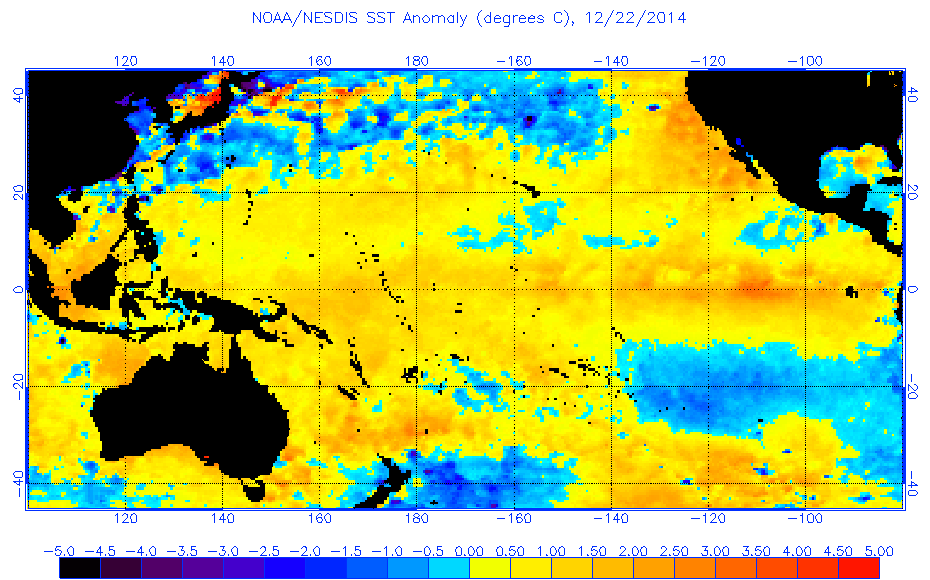
Just saying about a plunge of the Nino areas. Look at the graphics at the first post of thread.
0 likes
Visit the Caribbean-Central America Weather Thread where you can find at first post web cams,radars
and observations from Caribbean basin members Click Here
and observations from Caribbean basin members Click Here

Re: ENSO Updates
Today's update from the CPC:
Niño 4
1.0ºC
Niño 3.4
0.8ºC
Niño 3
0.8ºC
Niño 1+2
0.1ºC
Niño 4
1.0ºC
Niño 3.4
0.8ºC
Niño 3
0.8ºC
Niño 1+2
0.1ºC
0 likes
-
cycloneye
- Admin
- Posts: 139080
- Age: 67
- Joined: Thu Oct 10, 2002 10:54 am
- Location: San Juan, Puerto Rico
Re: ENSO Updates
http://www.cpc.noaa.gov/products/analys ... ts-web.pdf
0 likes
Visit the Caribbean-Central America Weather Thread where you can find at first post web cams,radars
and observations from Caribbean basin members Click Here
and observations from Caribbean basin members Click Here
Who is online
Users browsing this forum: chaser1 and 194 guests