Today's model guidance has the Bermuda High building back in much quicker than what was indicated yesterday for next week. As you pointed out gatorcane, we have not had an extended period where the Bermuda High has really established itself across Florida or the SE Atlantic coast this season. Now, it is still early, and the synoptic pattern can still have changes. But, if indeed the Bermuda High can flex its muscle and bring deep layered ridging to the region, then we will really have to start paying attention to what may be coming from the east or east/southeast.
In particular, if 97L can continue to hold its own for about another 36-48 hours and make it past 60 W longitude, it will migrate into a more conducive environment to develop. If the Bermuda High does indeed build in stronger and quicker by early next week, 97L may be a significant player for many people next week.
_____________________
The following is just the opinion of this poster and not an official forecast. Please refer to the latest information and products from the NWS and the NHC.
Florida Weather
Moderator: S2k Moderators
Forum rules

The posts in this forum are NOT official forecast and should not be used as such. They are just the opinion of the poster and may or may not be backed by sound meteorological data. They are NOT endorsed by any professional institution or STORM2K.
-
northjaxpro

- S2K Supporter

- Posts: 8900
- Joined: Mon Sep 27, 2010 11:21 am
- Location: Jacksonville, FL

Re: Florida Weather
Hey what's goin on everyone. I just moved to Orlando a couple of months ago and thought I would pop in and say what's up.
I also had a question question about the winter/spring severe weather season here in central Florida. I grew up in Alabama and lived in Texas for a good while, and severe weather is really my main interest.
I was reading a weather blog forecast the Winter 14'-15' Season and it showed central Florida having average/slightly above average temperatures as well as above normal precip. Not knowing a whole lot about severe weather season here, how do you think it will affect it?
0 likes
-
tropicwatch

- Category 5

- Posts: 3205
- Age: 60
- Joined: Sat Jun 02, 2007 10:01 am
- Location: Panama City Florida
- Contact:
Pretty good light shows with lightning!
0 likes
Tropicwatch
Agnes 72', Eloise 75, Elena 85', Kate 85', Charley 86', Florence 88', Beryl 94', Dean 95', Erin 95', Opal 95', Earl 98', Georges 98', Ivan 2004', Arlene 2005', Dennis 2005', Ida 2009' Debby 2012' Irma 2017' Michael 2018'
Agnes 72', Eloise 75, Elena 85', Kate 85', Charley 86', Florence 88', Beryl 94', Dean 95', Erin 95', Opal 95', Earl 98', Georges 98', Ivan 2004', Arlene 2005', Dennis 2005', Ida 2009' Debby 2012' Irma 2017' Michael 2018'
-
HURRICANELONNY
- Category 5
- Posts: 1381
- Joined: Wed May 07, 2003 6:48 am
- Location: HOLLYWOOD.FL
I"m not a pro met but they did a complete turn around for the front that was suppose to head in the gulf next week 9/15. It was suppose to favor the east coast for rain with a sw flow.
High pressure will then build across the region early next
week...with a more typical easterly flow rainy season pattern.
High pressure will then build across the region early next
week...with a more typical easterly flow rainy season pattern.
0 likes
hurricanelonny

Fairly wet September so far here in the Orlando area, today makes the 17th day out of 20 days so far this month that officially a trace of rain or higher has fallen. Tomorrow and Monday chances of rain drop as the low pressure moves away from our area but a wet pattern returns for most of the week.
0 likes
-
northjaxpro
- S2K Supporter
- Posts: 8900
- Joined: Mon Sep 27, 2010 11:21 am
- Location: Jacksonville, FL
Yeah, I have picked up a total of 11 inches of rain for the month at my locale, counting today's rainfall.
Yeah, it has been extremely wet this month, a sure indicator of El Nino with Low after Low moving through.
Yeah, it has been extremely wet this month, a sure indicator of El Nino with Low after Low moving through.
0 likes
NEVER, EVER SAY NEVER in the tropics and weather in general, and most importantly, with life itself!!
________________________________________________________________________________________
Fay 2008 Beryl 2012 Debby 2012 Colin 2016 Hermine 2016 Julia 2016 Matthew 2016 Irma 2017 Dorian 2019
________________________________________________________________________________________
Fay 2008 Beryl 2012 Debby 2012 Colin 2016 Hermine 2016 Julia 2016 Matthew 2016 Irma 2017 Dorian 2019
-
TheStormExpert

- Category 5
- Posts: 8487
- Age: 30
- Joined: Wed Feb 16, 2011 5:38 pm
- Location: Palm Beach Gardens, FL
0 likes
The following post is NOT an official forecast and should not be used as such. It is just the opinion of the poster and may or may not be backed by sound meteorological data. It is NOT endorsed by storm2k.org.

Re:
TheStormExpert wrote::uarrow: Any idea on what our winter could be like here in the Florida Peninsula? According to the CPC it very well could be at least somewhat cooler and wetter than average, especially the January-March timeframe as of now.
I too would like to know, especially since this El Nino event seems to be on the fence.
0 likes
This post is NOT AN OFFICIAL FORECAST and should not be used as such. It is just the opinion of the poster and may or may not be backed by sound meteorological data. It is NOT endorsed by any professional institution including storm2k.org. For Official Information please refer to the NHC and NWS products.
Re: Florida Weather
The good thing is that that NAO so far has been neutral to positive, I am praying for a positive NAO pattern
0 likes
-
TheStormExpert
- Category 5
- Posts: 8487
- Age: 30
- Joined: Wed Feb 16, 2011 5:38 pm
- Location: Palm Beach Gardens, FL
Re: Florida Weather
NDG wrote::uarrow: That it will be wetter than average with a weak El Nino looking very likely to stay during this winter is a given, the question is how cool will it be, our winters in the peninsula depend a lot on the state of the NAO, last winter we lucked out that the NAO for the most part stayed positive so most of the Peninsula stayed average to above average while the rest of the central and eastern US was freezing. The last weak El Nino '09/'10 winter there was a potent -NAO & -AO pattern, in combination with the El Nino that winter was one of the coldest for FL, if memory serves me correct we saw the coldest January/February ever here in Orlando. That February we never saw a day warmer than 76 degrees which was very unusual compared to February of this year that we saw highs in the mid to upper 80s seven times.
The good thing is that that NAO so far has been neutral to positive, I am praying for a positive NAO pattern
I thought an El Niño enhances the likelihood of a cooler than average winter for the Southeast (including the FL Peninsula)?
BTW, the CPC has backed off the idea of a cooler than average November-December period and is now leaning more towards above average (similar to how Nov.-Dec. '09 were). It looks like our best shot at having a possible cooler than average period here in the FL Peninsula will be from January-March (seems similar in ways to Jan.-Mar. of '10). The next 4-6 months should be wetter than average as a whole if the CPC's forecast pans out, we shall see though if an El Niño finally can form.
0 likes
The following post is NOT an official forecast and should not be used as such. It is just the opinion of the poster and may or may not be backed by sound meteorological data. It is NOT endorsed by storm2k.org.
Re: Florida Weather
'06/'07 was above average, 04/'05 slightly above average, '02/'03 below average Dec-Jan but above average Feb & March.
Interesting that temps during the Super El Nino '97/'98 were near average over all with not one single day of freezing temps officially in the Orlando area.
If you go back to previous years' NAO index you can see that the NAO index overall dictates the temps for central FL at the end not so much El Nino conditions.
0 likes
-
northjaxpro
- S2K Supporter
- Posts: 8900
- Joined: Mon Sep 27, 2010 11:21 am
- Location: Jacksonville, FL
More wet weather in store for much of this week as a mid level trough traverses the region through tomorrow. Also, another Cool, Canadian High Pressure dome, currently over the Eastern Great Lakes region, will build down the U.S. Eastern seaboard through the course of the week. This will bring northeast winds back into NE Florida region, and bring in additional convergent rain bands onshore beginning later tonight and into Wednesday and Thursday.
I have already measured just over 12 inches of rain for September to this point, and more to come to be added to this total for sure. What a wet month for sure. We have not had too much tropical cyclone activity this season, but these ever present cold core Lows/troughs moving through the region the past few weeks are bringing in plenty of rain nevertheless.
I was reading the posts above regarding the El Nino winter of 2009-10. One of the wettest and coldest winters in Florida that season. Also, if my memory serves me right, had light snow/ flurries at my locale in Jax that winter and sleet down into Central Florida. El Nino winters indeed can bring us winter precip if the NAO gets negative.
0 likes
NEVER, EVER SAY NEVER in the tropics and weather in general, and most importantly, with life itself!!
________________________________________________________________________________________
Fay 2008 Beryl 2012 Debby 2012 Colin 2016 Hermine 2016 Julia 2016 Matthew 2016 Irma 2017 Dorian 2019
________________________________________________________________________________________
Fay 2008 Beryl 2012 Debby 2012 Colin 2016 Hermine 2016 Julia 2016 Matthew 2016 Irma 2017 Dorian 2019
-
northjaxpro
- S2K Supporter
- Posts: 8900
- Joined: Mon Sep 27, 2010 11:21 am
- Location: Jacksonville, FL
I can vouch for sure that at least for one day, Fall is here in the Jax area. The temperature dropped to 62.7 degrees earlier this morning at my locale, and currently is only 65.4 degrees. Cool air damming along the Lee of the Appalachians bought in with the north/northeast flow to the Jax area is giving us a pleasant, albeit an overcast, cool day for our standards.
The northeast gradient will continue through to the latter part of this week as the Cool High Pressure dome builds down the U.S . Eastern seabord. This will also enhance the onshore convergence and bring in more rain to the Northeast/East Central coast pof the peninsula.
The northeast gradient will continue through to the latter part of this week as the Cool High Pressure dome builds down the U.S . Eastern seabord. This will also enhance the onshore convergence and bring in more rain to the Northeast/East Central coast pof the peninsula.
0 likes
NEVER, EVER SAY NEVER in the tropics and weather in general, and most importantly, with life itself!!
________________________________________________________________________________________
Fay 2008 Beryl 2012 Debby 2012 Colin 2016 Hermine 2016 Julia 2016 Matthew 2016 Irma 2017 Dorian 2019
________________________________________________________________________________________
Fay 2008 Beryl 2012 Debby 2012 Colin 2016 Hermine 2016 Julia 2016 Matthew 2016 Irma 2017 Dorian 2019
-
StormingB81

- S2K Supporter
- Posts: 5676
- Age: 42
- Joined: Thu Aug 27, 2009 1:45 am
- Location: Rockledge, Florida
Re: Florida Weather
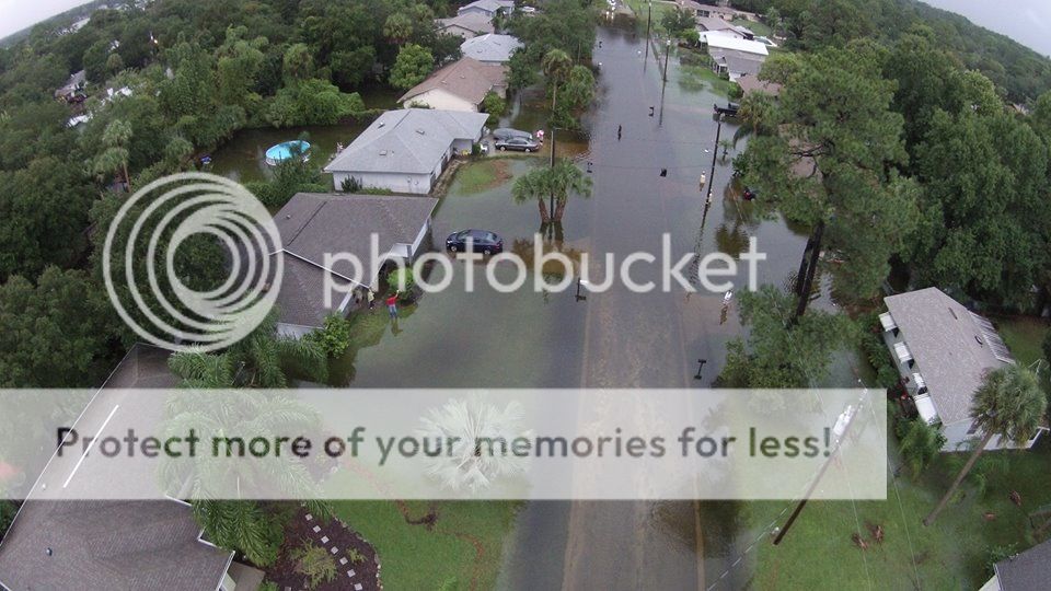
I could post A LOT more images from around here from Winter Park to New Symrna Beach and every where in between. Some sports had almost 7 inches of rain with a lot of folks getting between five and six inches. Most over 1-2 inches. AND more of the wet stuff foretasted through the end of the week with a stalled front. Weatherman said this is the most rain in one day since Tropical Storm Fay in 2008.

0 likes
-
northjaxpro
- S2K Supporter
- Posts: 8900
- Joined: Mon Sep 27, 2010 11:21 am
- Location: Jacksonville, FL
The latest visible satellite view of the U.S. East Coast paints the picture well as the cool air stratocumulus deck extends all the way from Northeast Florida up through the Carolinas and to the Northeast U.S., and the stalled out front across the North Central peninsula of Florida.
Last edited by northjaxpro on Wed Sep 24, 2014 7:57 pm, edited 1 time in total.
0 likes
NEVER, EVER SAY NEVER in the tropics and weather in general, and most importantly, with life itself!!
________________________________________________________________________________________
Fay 2008 Beryl 2012 Debby 2012 Colin 2016 Hermine 2016 Julia 2016 Matthew 2016 Irma 2017 Dorian 2019
________________________________________________________________________________________
Fay 2008 Beryl 2012 Debby 2012 Colin 2016 Hermine 2016 Julia 2016 Matthew 2016 Irma 2017 Dorian 2019
-
northjaxpro
- S2K Supporter
- Posts: 8900
- Joined: Mon Sep 27, 2010 11:21 am
- Location: Jacksonville, FL
The East Central coast has really been deluged the past 24 hours, especially the Daytona Beach area where the stalled out front is sitting right on top of them. They have been hit hard down there with about 8 inches of rain the past 24 hours, recorded at the Daytona Beach International Airport right near the Speedway. Flooding has occured around there, and other spots across that area. Heavy rain also measured just outside the Orlando metro as well and down to the Space Coast region.
NWS WFO in Melbourne just released the 24 hour rainfall totals through 12:30 this afternoon across some areas of East Central Florida:
DAYTONA BEACH INTERNATIONAL 7.95 IN
SSE LAKE MARY 6.41 IN
SE ORMOND BEACH 6.37 IN
N EDGEWATER 5.58 IN
NW LAKE MARY 4.56 IN
NNW MAGIC KINGDOM 4.27 IN
ESE WEST MELBOURNE 3.76 IN
E FAIRVILLA 3.70 IN
NW ALOMA 3.51 IN
NW MALABAR 3.15 IN
WNW OVIEDO 3.09 IN
E UNION PARK 2.90 IN
ESE VERO BEACH SOUTH 2.90 IN
NW FOREST CITY 2.52 IN
W WINDERMERE 2.43 IN
NW FOREST CITY 2.43 IN
NW FERN PARK 2.41 IN
ESE VERO BEACH SOUTH 2.35 IN
SSW WEST MELBOURNE 2.23 IN
UNION PARK 2.17 IN
NW GROVENOR ESTATES 2.06 IN
KISSIMMEE 2.00 IN
N LADY LAKE 1.99 IN
0 likes
NEVER, EVER SAY NEVER in the tropics and weather in general, and most importantly, with life itself!!
________________________________________________________________________________________
Fay 2008 Beryl 2012 Debby 2012 Colin 2016 Hermine 2016 Julia 2016 Matthew 2016 Irma 2017 Dorian 2019
________________________________________________________________________________________
Fay 2008 Beryl 2012 Debby 2012 Colin 2016 Hermine 2016 Julia 2016 Matthew 2016 Irma 2017 Dorian 2019
Re:
northjaxpro wrote:The East Central coast has really been deluged the past 24 hours, especially the Daytona Beach area where the stalled out front is sitting right on top of them. They have been hit hard down there with about 8 inches of rain the past 24 hours, recorded at the Daytona Beach International Airport right near the Speedway. Flooding has occured around there, and other spots across that area. Heavy rain also measured just outside the Orlando metro as well and down to the Space Coast region.
NWS WFO in Melbourne just released the 24 hour rainfall totals through 12:30 this afternoon across some areas of East Central Florida:
DAYTONA BEACH INTERNATIONAL 7.95 IN
SSE LAKE MARY 6.41 IN
SE ORMOND BEACH 6.37 IN
N EDGEWATER 5.58 IN
NW LAKE MARY 4.56 IN
NNW MAGIC KINGDOM 4.27 IN
ESE WEST MELBOURNE 3.76 IN
E FAIRVILLA 3.70 IN
NW ALOMA 3.51 IN
NW MALABAR 3.15 IN
WNW OVIEDO 3.09 IN
E UNION PARK 2.90 IN
ESE VERO BEACH SOUTH 2.90 IN
NW FOREST CITY 2.52 IN
W WINDERMERE 2.43 IN
NW FOREST CITY 2.43 IN
NW FERN PARK 2.41 IN
ESE VERO BEACH SOUTH 2.35 IN
SSW WEST MELBOURNE 2.23 IN
UNION PARK 2.17 IN
NW GROVENOR ESTATES 2.06 IN
KISSIMMEE 2.00 IN
N LADY LAKE 1.99 IN
Yeah, my house in Audubon Park in Orlando got a lot of rain also thanks to the old front and sea breeze and outflow boundaries converging. Major rain in other parts of Central Florida, as said by northjaxpro and media outlets.
For the next 10 days according to the Weather Channel, http://www.weather.com/weather/tenday/MCO:9 we will see a very wet pattern, with no real cool weather (although cooler than summer with mid upper 80s highs and low 70s lows). Basically this means that the wet season is still on.
Anyone see any potential cooler weather in the extended period?
0 likes
This post is NOT AN OFFICIAL FORECAST and should not be used as such. It is just the opinion of the poster and may or may not be backed by sound meteorological data. It is NOT endorsed by any professional institution including storm2k.org. For Official Information please refer to the NHC and NWS products.
-
northjaxpro
- S2K Supporter
- Posts: 8900
- Joined: Mon Sep 27, 2010 11:21 am
- Location: Jacksonville, FL
The NWS office in Jacksonville recorded a maximum temperature today of 72 degrees, which tied the record for the lowest maximum temperature for this date, which was initially set in 1928.
It really felt like Fall here today. Gives me more anticipatiion for the cooler weather to come in this regioni in earnst within the next 4 to 6 weeks.
It really felt like Fall here today. Gives me more anticipatiion for the cooler weather to come in this regioni in earnst within the next 4 to 6 weeks.
0 likes
NEVER, EVER SAY NEVER in the tropics and weather in general, and most importantly, with life itself!!
________________________________________________________________________________________
Fay 2008 Beryl 2012 Debby 2012 Colin 2016 Hermine 2016 Julia 2016 Matthew 2016 Irma 2017 Dorian 2019
________________________________________________________________________________________
Fay 2008 Beryl 2012 Debby 2012 Colin 2016 Hermine 2016 Julia 2016 Matthew 2016 Irma 2017 Dorian 2019
-
northjaxpro
- S2K Supporter
- Posts: 8900
- Joined: Mon Sep 27, 2010 11:21 am
- Location: Jacksonville, FL
As for cooler weather, long range GFS out 10-14 days is indicating 500 mb heights rising significantly across the Eastern U.S., which suggests a significant ridge heading into the start of October if this verifies. So, if the GFS is right, definitely no cool down anytime soon. I would be inclined to think at least here in North Florida that our first significant cool down will not come until mid October at the earliest.
0 likes
NEVER, EVER SAY NEVER in the tropics and weather in general, and most importantly, with life itself!!
________________________________________________________________________________________
Fay 2008 Beryl 2012 Debby 2012 Colin 2016 Hermine 2016 Julia 2016 Matthew 2016 Irma 2017 Dorian 2019
________________________________________________________________________________________
Fay 2008 Beryl 2012 Debby 2012 Colin 2016 Hermine 2016 Julia 2016 Matthew 2016 Irma 2017 Dorian 2019
-
StormingB81
- S2K Supporter
- Posts: 5676
- Age: 42
- Joined: Thu Aug 27, 2009 1:45 am
- Location: Rockledge, Florida
Daytona Beach has already passed the yearly avg..Funny its not even October but if they have not one more drop of rain they will still be an inch above average. And I know where I am in Orlando we are 2 inches above normal for this time..not as much as Daytona but still seen a lot of rain this year
0 likes
Return to “USA & Caribbean Weather”
Who is online
Users browsing this forum: bubba hotep, Cpv17, duilaslol, Haddox12, snownado and 155 guests