
I have come to the conclusion that the main problem with using the Stat Method of Weather Forecasting is that when it nails down a storm system over a week before it is expected to move into north Texas, the storm seems like it takes forever for it to get here! But Thursday is finally almost here, and our storm system, along with its attendant cold front, will be sweeping across north Texas tomorrow afternoon and evening bringing a good chance of showers and thunderstorms to much of the Metroplex and up to half of all of north Texas !
Scattered storms will first fire Thursday afternoon just west and northwest of the Metroplex and then build south, eventually forming a solid line early Thursday evening as they cross the I-35 Corridor on their way to east and southeast Texas. Some - though not all - storms will be severe with hail, brief but very heavy rain, and strong straightline winds. We will be watching for any storm that manages to stay isolated from the line for the possibility of developing a rotating updraft which could lead to tornado spinup. But the line should form fairly quickly making straightline winds the main threat.
Rainfall amounts will range from a " I-waited-a-whole-week-to-get-just-a-trace," to locally over an inch or two in the heavier storms. And for those who get over an inch, that amount may come down in less than 30 minutes! It could be a blinding rain. For those who get just a trace or not so much as a single drop, you may want to start composing your tale of woe and disappointment to post to this page Thursday evening
But seriously, keep an eye to the skies tomorrow as we enter our secondary severe weather season here in north Texas. And for our talented photographers ... there should be quite an impressive line of thunderheads just east of the Metroplex after sundown Thursday, going off like some spastic array of light bulbs with frequent and intense lightning shooting out the sides and tops of the clouds!
Texas Fall-2014
Moderator: S2k Moderators
Forum rules

The posts in this forum are NOT official forecast and should not be used as such. They are just the opinion of the poster and may or may not be backed by sound meteorological data. They are NOT endorsed by any professional institution or STORM2K.
Re: Texas Fall-2014
From our good friend, Steve McCauley:

0 likes

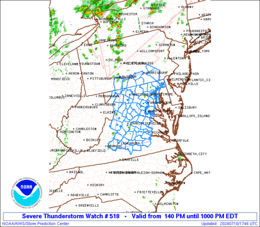
Looks like all of North Texas under a severe thunderstorm WATCH until 9PM tonight.
0 likes
The above post and any post by dhweather is NOT an official forecast and should not be used as such. It is just the opinion of the poster and may or may not be backed by sound meteorological data. It is NOT endorsed by any professional institution including storm2k.org. For official information, please refer to NWS products.
SPC text:
SEL8
URGENT - IMMEDIATE BROADCAST REQUESTED
SEVERE THUNDERSTORM WATCH NUMBER 518
NWS STORM PREDICTION CENTER NORMAN OK
155 PM CDT THU OCT 2 2014
THE NWS STORM PREDICTION CENTER HAS ISSUED A
* SEVERE THUNDERSTORM WATCH FOR PORTIONS OF
FAR SOUTHEAST OKLAHOMA
NORTH-CENTRAL AND NORTHEAST INTO CENTRAL TEXAS
* EFFECTIVE THIS THURSDAY AFTERNOON AND EVENING FROM 155 PM UNTIL
900 PM CDT.
* PRIMARY THREATS INCLUDE...
ISOLATED VERY LARGE HAIL EVENTS TO 2 INCHES IN DIAMETER POSSIBLE
ISOLATED DAMAGING WIND GUSTS TO 70 MPH POSSIBLE
THE SEVERE THUNDERSTORM WATCH AREA IS APPROXIMATELY ALONG AND 80
STATUTE MILES EAST AND WEST OF A LINE FROM 35 MILES NORTHWEST OF
PARIS TEXAS TO 40 MILES SOUTHWEST OF TEMPLE TEXAS. FOR A
COMPLETE DEPICTION OF THE WATCH SEE THE ASSOCIATED WATCH OUTLINE
UPDATE (WOUS64 KWNS WOU8).
PRECAUTIONARY/PREPAREDNESS ACTIONS...
REMEMBER...A SEVERE THUNDERSTORM WATCH MEANS CONDITIONS ARE
FAVORABLE FOR SEVERE THUNDERSTORMS IN AND CLOSE TO THE WATCH
AREA. PERSONS IN THESE AREAS SHOULD BE ON THE LOOKOUT FOR
THREATENING WEATHER CONDITIONS AND LISTEN FOR LATER STATEMENTS
AND POSSIBLE WARNINGS. SEVERE THUNDERSTORMS CAN AND OCCASIONALLY
DO PRODUCE TORNADOES.
&&
OTHER WATCH INFORMATION...CONTINUE...WW 515...WW 516...WW 517...
DISCUSSION...TSTMS ARE EXPECTED TO INCREASE IN COVERAGE AND
INTENSITY ALONG A SEWD-MOVING COLD FRONT THIS AFTERNOON AS
LARGE-SCALE FORCING FOR ASCENT IS ENHANCED BY A MID-LEVEL TROUGH
MOVING ACROSS THE SRN PLAINS. MODERATE AMOUNTS OF INSTABILITY AND
VERTICAL SHEAR WILL SUPPORT SUPERCELLS AND BOWING STRUCTURES WITH
THE MAIN HAZARDS BEING DAMAGING WINDS AND LARGE HAIL.
AVIATION...A FEW SEVERE THUNDERSTORMS WITH HAIL SURFACE AND ALOFT
TO 2 INCHES. EXTREME TURBULENCE AND SURFACE WIND GUSTS TO 60
KNOTS. A FEW CUMULONIMBI WITH MAXIMUM TOPS TO 550. MEAN STORM
MOTION VECTOR 26025.
...MEAD
0 likes
The above post and any post by dhweather is NOT an official forecast and should not be used as such. It is just the opinion of the poster and may or may not be backed by sound meteorological data. It is NOT endorsed by any professional institution including storm2k.org. For official information, please refer to NWS products.
Re: Texas Fall-2014
0 likes
The above post and any post by dhweather is NOT an official forecast and should not be used as such. It is just the opinion of the poster and may or may not be backed by sound meteorological data. It is NOT endorsed by any professional institution including storm2k.org. For official information, please refer to NWS products.
-
South Texas Storms

- Professional-Met

- Posts: 4005
- Joined: Thu Jun 24, 2010 12:28 am
- Location: Houston, TX
Re: Texas Fall-2014
0 likes
Re: Texas Fall-2014
South Texas Storms wrote::uarrow: I don't think this line of strong/severe thunderstorms will be missing you dhweather. Line looks to be filling in nicely. Enjoy!
Boy I hope so. It's thicker and more solid from Denton northward, it gets more narrow and there are some breaks south of Denton. Hope it fills in very nicely before it gets here!
0 likes
The above post and any post by dhweather is NOT an official forecast and should not be used as such. It is just the opinion of the poster and may or may not be backed by sound meteorological data. It is NOT endorsed by any professional institution including storm2k.org. For official information, please refer to NWS products.
-
BrokenGlassRepublicn
- Category 1

- Posts: 479
- Joined: Sun Nov 20, 2011 8:07 pm
- Location: Richardson, Texas
Re: Texas Fall-2014
Gotten .53 inches in a fairly short amount of time. Pretty good rain out there. Also my back door blew open, but things seem okay other than that.
0 likes
-
TheProfessor

- Professional-Met
- Posts: 3505
- Age: 27
- Joined: Tue Dec 03, 2013 10:56 am
- Location: Wichita, Kansas
-
Ralph's Weather
- S2K Supporter

- Posts: 2968
- Age: 36
- Joined: Fri Dec 13, 2013 11:55 am
- Location: Lindale, TX
Looks like the storms are now moving out of DFW and into E TX along with their 70-80 mph winds. There appears to be some significant damage left behind in DFW. Any chance they weaken or at least the winds slack up as they move east?
0 likes
Follow on Facebook at Ralph's Weather.
That was quite a line of storms, some damage Arlington eastward.
0 likes
The above post and any post by Ntxw is NOT an official forecast and should not be used as such. It is just the opinion of the poster and may or may not be backed by sound meteorological data. It is NOT endorsed by any professional institution including Storm2k. For official information, please refer to NWS products.
Help support Storm2K!

Re: Texas Fall-2014
The strongest winds I have ever seen here in Cedar Hill. Lots of cleaning up to do.


0 likes
Lots of wind damage scattered around the metroplex, hope everyone is ok.
I recorded 0.35" of rain, which I will gladly take! We had gusts in the 50's and some sparse small hail, dime to nickel size.
I recorded 0.35" of rain, which I will gladly take! We had gusts in the 50's and some sparse small hail, dime to nickel size.
0 likes
The above post and any post by dhweather is NOT an official forecast and should not be used as such. It is just the opinion of the poster and may or may not be backed by sound meteorological data. It is NOT endorsed by any professional institution including storm2k.org. For official information, please refer to NWS products.
-
Portastorm

- Storm2k Moderator

- Posts: 9787
- Age: 61
- Joined: Fri Jul 11, 2003 9:16 am
- Location: South Austin, TX
- Contact:
Re:
dhweather wrote:Lots of wind damage scattered around the metroplex, hope everyone is ok.
I recorded 0.35" of rain, which I will gladly take! We had gusts in the 50's and some sparse small hail, dime to nickel size.
Better go buy a lottery ticket, tonight, pal.
Glad to hear it actually rained in Heath. Here's to many more events like that (except for the severe weather, of course).
0 likes
Any forecasts under my name are to be taken with a grain of salt. Get your best forecasts from the National Weather Service and National Hurricane Center.
I'm a certified Advanced SKYWARN-trained spotter and am active on Twitter at @TravisCOSW, a social media partner of the NWS Austin-San Antonio office.
I'm a certified Advanced SKYWARN-trained spotter and am active on Twitter at @TravisCOSW, a social media partner of the NWS Austin-San Antonio office.
-
Portastorm
- Storm2k Moderator
- Posts: 9787
- Age: 61
- Joined: Fri Jul 11, 2003 9:16 am
- Location: South Austin, TX
- Contact:
Re: Texas Fall-2014
So, I also saw this on Twitter earlier today ... hopefully today's rain did at least a little bit to ease this:

0 likes
Any forecasts under my name are to be taken with a grain of salt. Get your best forecasts from the National Weather Service and National Hurricane Center.
I'm a certified Advanced SKYWARN-trained spotter and am active on Twitter at @TravisCOSW, a social media partner of the NWS Austin-San Antonio office.
I'm a certified Advanced SKYWARN-trained spotter and am active on Twitter at @TravisCOSW, a social media partner of the NWS Austin-San Antonio office.
Re: Texas Fall-2014
Portastorm wrote:So, I also saw this on Twitter earlier today ... hopefully today's rain did at least a little bit to ease this:
Ironic that looks somewhat like a hook echo return on radar.
0 likes
The above post and any post by dhweather is NOT an official forecast and should not be used as such. It is just the opinion of the poster and may or may not be backed by sound meteorological data. It is NOT endorsed by any professional institution including storm2k.org. For official information, please refer to NWS products.
Re: Texas Fall-2014
Portastorm wrote:So, I also saw this on Twitter earlier today ... hopefully today's rain did at least a little bit to ease this:
http://i61.tinypic.com/2la96dy.png
Today's rainfall probably didn't do much to dent it but of course we'll take any we can get. I'm checking some guidance and ontop of the usual suspects we've looked at for cool shot signals there is also hints of semi-permanent baja low setting up. I hope this verifies because with rising AAM it bodes well for the EPAC to pick up again.
Short term next few mornings will be quite pleasant across the state most in the 50s and daytime highs are seasonable 70s and low 80s. Some gorgeous October state fair weather this weekend.
0 likes
The above post and any post by Ntxw is NOT an official forecast and should not be used as such. It is just the opinion of the poster and may or may not be backed by sound meteorological data. It is NOT endorsed by any professional institution including Storm2k. For official information, please refer to NWS products.
Help support Storm2K!
Help support Storm2K!
-
TheProfessor
- Professional-Met
- Posts: 3505
- Age: 27
- Joined: Tue Dec 03, 2013 10:56 am
- Location: Wichita, Kansas
Re: Texas Fall-2014
dhweather wrote:Portastorm wrote:So, I also saw this on Twitter earlier today ... hopefully today's rain did at least a little bit to ease this:
Ironic that looks somewhat like a hook echo return on radar.
lol, I would not want to be in the path of a Tornado in that size of a hook echo!
0 likes
An alumnus of The Ohio State University.
Your local National Weather Service office is your best source for weather information.
Your local National Weather Service office is your best source for weather information.
-
weatherdude1108
- Category 5

- Posts: 4172
- Joined: Tue Dec 13, 2011 1:04 pm
- Location: Northwest Austin/Cedar Park, TX
Well, I thought the line was congealing down here. But I am watching it break up over the hill country before it gets here, yet they extended the severe storm watch until 3AM(??). They must be seeing something I am not. I don't want severe weather, but rain would be welcome. It has been exactly two weeks to the day that I have had measurable rain. Hmmm. 
0 likes
Return to “USA & Caribbean Weather”
Who is online
Users browsing this forum: cajungal, Google Adsense [Bot] and 137 guests