Texas Fall-2015

U.S. & Caribbean Weather Discussions and Severe Weather Events

Moderator: S2k Moderators

Forum rules

The posts in this forum are NOT official forecast and should not be used as such. They are just the opinion of the poster and may or may not be backed by sound meteorological data. They are NOT endorsed by any professional institution or STORM2K.

Help Support Storm2K
Message
Author
User avatar
TheProfessor
Professional-Met
Professional-Met
Posts: 3505
Age: 27
Joined: Tue Dec 03, 2013 10:56 am
Location: Wichita, Kansas

#61 Postby TheProfessor » Fri Sep 04, 2015 6:05 am

Well a Guy in another forum posted a very very very long range cfs maps, something to look forward to maybe :lol:

November 26-
Image
photo uploading websites

November 27-

Image
screen shot on windows

Image
screen capture software

Though the high will probably end up being 65 and sunny or something lol.
0 likes   
An alumnus of The Ohio State University.

Your local National Weather Service office is your best source for weather information.

User avatar
TeamPlayersBlue
Category 5
Category 5
Posts: 3307
Joined: Tue Feb 02, 2010 1:44 am
Location: Denver/Applewood, CO

#62 Postby TeamPlayersBlue » Fri Sep 04, 2015 6:29 am

In regards to this summer, while it was brutal for parts of it, the last couple weeks here in Houston been not too bad. High around 90 with random showers on some days. Other days were very dry and beautiful with a low in the high 60's. It could be worse at this moment!
0 likes   
Personal Forecast Disclaimer:
The posts in this forum are NOT official forecast and should not be used as such. They are just the opinion of the poster and may or may not be backed by sound meteorological data. They are NOT endorsed by any professional institution or storm2k.org. For official information, please refer to the NHC and NWS products.

weatherdude1108
Category 5
Category 5
Posts: 4172
Joined: Tue Dec 13, 2011 1:04 pm
Location: Northwest Austin/Cedar Park, TX

#63 Postby weatherdude1108 » Fri Sep 04, 2015 6:31 am

Long-term teaser at the end. :eek: :)

AREA FORECAST DISCUSSION
NATIONAL WEATHER SERVICE AUSTIN/SAN ANTONIO TX
407 AM CDT FRI SEP 4 2015

LONG TERM (SATURDAY NIGHT THROUGH THURSDAY)...
AN UPPER LEVEL HIGH PRESSURE ACROSS CENTRAL TEXAS WILL DOMINATE
FROM SUNDAY INTO THE MIDDLE OF NEXT WEEK. HOWEVER...CANT RULE OUT
FEW STORMS AFFECTING THE COASTAL PLAINS AND PARTS OF THE SOUTHEAST
COUNTIES EACH AFTERNOON MONDAY THROUGH WEDNESDAY. BY
THURSDAY...THE UPPER LEVEL HIGH PUSHES SOUTHWEST INTO CENTRAL
MEXICO AND WEAKENS WHILE AN UPPER SHORT-WAVE TROUGH SWINGS ACROSS
THE NORTHERN PLAINS INTO THE GREAT LAKES. A COLD FRONT ASSOCIATED
WITH THE UPPER SHORT-WAVE IS FORECAST TO APPROACH THE AREA LATE
THURSDAY INTO FRIDAY.
ECM AND GFS ARE NOT IN GOOD AGREEMENT WITH
THE TIMING AND PASSAGE OF THE BOUNDARY ACROSS OUR AREA. FOR THIS
PACKAGE...OPTED TO DO A MODEL BLEND. HOWEVER...IF GFS VERIFIES
(WETTEST MODEL PER LATEST RUN)...SOME AREAS MAY GET SEVERAL
INCHES OF RAIN. STAY TUNED
.
0 likes   
The preceding post is NOT an official forecast, and should not be used as such. It is only the opinion of the poster and may or may not be backed by sound meteorological data. It is NOT endorsed by any professional institution including storm2k.org. For Official Information please refer to the NHC and NWS products.

User avatar
CaptinCrunch
S2K Supporter
S2K Supporter
Posts: 8569
Age: 56
Joined: Mon Nov 03, 2003 4:33 pm
Location: Lake Worth, TX (Tarrant Co.)

#64 Postby CaptinCrunch » Fri Sep 04, 2015 8:49 am

Summer 2015 for NTX (Jun-Aug) averaged out to 1.3 degrees above normal high for temps.
We only recorded 13 days of 100+ temps, that's 5 below the summer average.
Rainfall was 2.52" below normal for the summer average.

Now for fall (Sept-Nov) several of the local TV mets have been talking about the long range models and a pattern change. They are talking about above average rainfall of 2" to 4" and cooler than normal temps.
0 likes   

aggiecutter
Category 5
Category 5
Posts: 1743
Joined: Thu Oct 14, 2004 9:22 pm
Location: Texarkana

Re: Texas Fall-2015

#65 Postby aggiecutter » Fri Sep 04, 2015 9:27 am

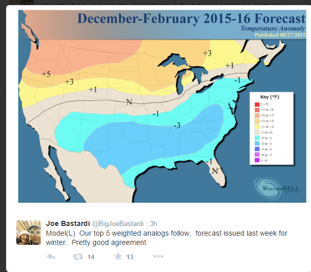
Weatherbell winter forecast(freebie from JB on Twitter). The only part of it I disagree with is that I think the Austin area will be well above normal temperature wise and well below normal for precipitation, especially SW Austin.

Image
0 likes   

User avatar
TheProfessor
Professional-Met
Professional-Met
Posts: 3505
Age: 27
Joined: Tue Dec 03, 2013 10:56 am
Location: Wichita, Kansas

#66 Postby TheProfessor » Fri Sep 04, 2015 9:36 am

:uarrow: They were probably too lazy to leave a donut hole and just put fill all :lol:
0 likes   
An alumnus of The Ohio State University.

Your local National Weather Service office is your best source for weather information.

User avatar
TheProfessor
Professional-Met
Professional-Met
Posts: 3505
Age: 27
Joined: Tue Dec 03, 2013 10:56 am
Location: Wichita, Kansas

#67 Postby TheProfessor » Fri Sep 04, 2015 9:47 am

My guess for 59 would be
DFW- 9/21
IAH- 10/12
AUS- 10/5
0 likes   
An alumnus of The Ohio State University.

Your local National Weather Service office is your best source for weather information.

weatherdude1108
Category 5
Category 5
Posts: 4172
Joined: Tue Dec 13, 2011 1:04 pm
Location: Northwest Austin/Cedar Park, TX

Re: Texas Fall-2015

#68 Postby weatherdude1108 » Fri Sep 04, 2015 10:03 am

aggiecutter wrote:Weatherbell winter forecast(freebie from JB on Twitter). The only part of it I disagree with is that I think the Austin area will be well above normal temperature wise and well below normal for precipitation, especially SW Austin.

Image


Yeah yeah. Kind of funny. Although not sure Porta would agree. :P
I'm just ready for some cool and rainy Fall football weather! :tailgate:
0 likes   

aggiecutter
Category 5
Category 5
Posts: 1743
Joined: Thu Oct 14, 2004 9:22 pm
Location: Texarkana

Re:

#69 Postby aggiecutter » Fri Sep 04, 2015 12:12 pm

TheProfessor wrote::uarrow: They were probably too lazy to leave a donut hole and just put fill all :lol:


That's what I was thinking.
0 likes   

User avatar
Portastorm
Storm2k Moderator
Storm2k Moderator
Posts: 9787
Age: 61
Joined: Fri Jul 11, 2003 9:16 am
Location: South Austin, TX
Contact:

Re: Texas Fall-2015

#70 Postby Portastorm » Fri Sep 04, 2015 12:20 pm

weatherdude1108 wrote:
aggiecutter wrote:Weatherbell winter forecast(freebie from JB on Twitter). The only part of it I disagree with is that I think the Austin area will be well above normal temperature wise and well below normal for precipitation, especially SW Austin.


Yeah yeah. Kind of funny. Although not sure Porta would agree. :P
I'm just ready for some cool and rainy Fall football weather! :tailgate:


It's a good thing aggiecutter's forecasts are as often incorrect as those from the PWC. I like SW Austin's chances this coming winter!

Meanwhile, back to our current weather, both the GFS and Euro are showing a nice front next weekend with rainfall between 1/2" to 1" for South Central Texas.
0 likes   
Any forecasts under my name are to be taken with a grain of salt. Get your best forecasts from the National Weather Service and National Hurricane Center.

I'm a certified Advanced SKYWARN-trained spotter and am active on Twitter at @TravisCOSW, a social media partner of the NWS Austin-San Antonio office.

Brent
S2K Supporter
S2K Supporter
Posts: 37090
Age: 35
Joined: Sun May 16, 2004 10:30 pm
Location: Tulsa Oklahoma
Contact:

Re: Texas Fall-2015

#71 Postby Brent » Fri Sep 04, 2015 1:10 pm

The 12z GFS has 50's for DFW on September 18th and 19th. :ggreen:

Also, in less fantasy land world: Widespread rain for most of Texas next Friday/Saturday
0 likes   
#neversummer

weatherdude1108
Category 5
Category 5
Posts: 4172
Joined: Tue Dec 13, 2011 1:04 pm
Location: Northwest Austin/Cedar Park, TX

#72 Postby weatherdude1108 » Fri Sep 04, 2015 1:20 pm

Nice change, for a change. :cheesy:
Image
0 likes   
The preceding post is NOT an official forecast, and should not be used as such. It is only the opinion of the poster and may or may not be backed by sound meteorological data. It is NOT endorsed by any professional institution including storm2k.org. For Official Information please refer to the NHC and NWS products.

weatherdude1108
Category 5
Category 5
Posts: 4172
Joined: Tue Dec 13, 2011 1:04 pm
Location: Northwest Austin/Cedar Park, TX

#73 Postby weatherdude1108 » Fri Sep 04, 2015 1:25 pm

Keep the faith! :ggreen:

Bob Rose:

There looks to be little change in the weather next Tuesday through Thursday. Sunny and hot weather will continue with high temperatures generally in the upper 90s. A couple of 100-degree temperatures are not out of the question.

But changes in the weather pattern do look to occur late next week when the ridge of high pressure weakens and shifts west, allowing a trough of low pressure to develop south from the northern Plains region. The trough will allow a weak cold front to sink south through the Plains states late next week. The front looks to push into North Texas next Thursday and slowly sink into Central Texas on Friday. Scattered rain showers and thunderstorms are forecast to accompany the cold front as it moves south. Some rain may linger into next weekend as well. Slightly cooler temperatures are forecast next weekend behind the front with highs around 88-90 degrees.

Looking beyond next weekend, a more active pattern is forecast as the summertime ridge stays away from Texas.

Be patient and keep the faith. Changes in the weather pattern are on the horizon.


Bob


http://www.lcra.org/water/river-and-wea ... ather.aspx
0 likes   
The preceding post is NOT an official forecast, and should not be used as such. It is only the opinion of the poster and may or may not be backed by sound meteorological data. It is NOT endorsed by any professional institution including storm2k.org. For Official Information please refer to the NHC and NWS products.

weatherdude1108
Category 5
Category 5
Posts: 4172
Joined: Tue Dec 13, 2011 1:04 pm
Location: Northwest Austin/Cedar Park, TX

#74 Postby weatherdude1108 » Fri Sep 04, 2015 3:10 pm

The afternoon package from EWX looks a little more promising than this morning's.

Been a long time coming! This past Spring with the rains is a distant memory after the infamous July and August 2015 flash drought.
:sun: :onfire:

Bring on the wet!
:rain: :lightning: :rain: :lightning: :rain:

AREA FORECAST DISCUSSION
NATIONAL WEATHER SERVICE AUSTIN/SAN ANTONIO TX
251 PM CDT FRI SEP 4 2015

.LONG TERM (SUNDAY THROUGH FRIDAY)...
FOR THE LATER HALF OF THE LABOR DAY WEEKEND INTO THE EARLY PART OF
NEXT WEEK...THE MID AND UPPER LEVEL RIDGE PERSISTS OVER TEXAS. THE
AIRMASS REMAINS DRIER WITH ONLY ISOLATED SHOWERS AND THUNDERSTORMS
POSSIBLE NEAR THE COASTAL PLAINS. DURING THE MID TO LATE PART OF
NEXT WEEK...RIDGE SLIDES OFF TO THE SOUTHWEST INTO NORTHWESTERN
MEXICO AS A SERIES OF UPPER LEVEL TROUGHS MOVE ACROSS THE NORTHERN
TIER OF STATES. A DEVELOPING NORTHWESTERLY FLOW ALOFT ALLOWS A
COLD FRONT TO SAG SOUTH INTO TEXAS. SOME TIMING DIFFERENCES REMAIN
AMONG THE MODELS ON THE FRONTAL PASSAGE FOR SOUTH CENTRAL TEXAS
WITH GEM WEDNESDAY NIGHT...ECMWF THURSDAY AND GFS FRIDAY. TO ADD A
NEW WRINKLE TO THE FORECAST...THE MOST RECENT RUN OF THE ECMWF NOW
DEVELOPS AN UPPER LEVEL LOW OVER CENTRAL TEXAS FRIDAY. INCREASING
MOISTURE AND UPWARD FORCING ALONG AND BEHIND THE FRONTAL ZONE AND
POSSIBLE UPPER LEVEL LOW RESULTS IN A GREATER AREAL COVERAGE OF
SHOWERS AND THUNDERSTORMS ACROSS MUCH OF SOUTH CENTRAL TEXAS
WEDNESDAY THROUGH FRIDAY. SLOW MOVEMENT AND TRAINING OF STORMS
COULD LEAD TO HEAVIER RAINS.
ABOVE NORMAL TEMPERATURES WILL COOL
LATE NEXT WEEK DUE TO CLOUDS AND RAIN.

&&
0 likes   
The preceding post is NOT an official forecast, and should not be used as such. It is only the opinion of the poster and may or may not be backed by sound meteorological data. It is NOT endorsed by any professional institution including storm2k.org. For Official Information please refer to the NHC and NWS products.

Brent
S2K Supporter
S2K Supporter
Posts: 37090
Age: 35
Joined: Sun May 16, 2004 10:30 pm
Location: Tulsa Oklahoma
Contact:

Re: Texas Fall-2015

#75 Postby Brent » Fri Sep 04, 2015 3:54 pm

FWD putting the nail in the coffin on summer:

Image

AREA FORECAST DISCUSSION
NATIONAL WEATHER SERVICE FORT WORTH TX
343 PM CDT FRI SEP 4 2015

.DISCUSSION...
AN UPPER LEVEL HIGH WILL INTENSIFY AND SIT RIGHT OVER THE HEART OF
TEXAS THIS WEEKEND. THE INCREASING SUBSIDENCE ALOFT WILL RESULT IN
WARMING TEMPERATURES AND A SUPPRESSION OF CONVECTIVE POTENTIAL
DESPITE A NOTABLE INCREASE IN DEEP LAYER MOISTURE. HOWEVER
BECAUSE PRECIPITABLE WATER WILL BE NEAR OR EXCEED 2 INCHES ACROSS
THE EASTERN HALF OF THE AREA...WE CANT DISCOUNT THE LOW POTENTIAL
FOR A FEW ISOLATED SHOWERS AND STORMS DURING THE HEAT OF THE DAY.
WILL SHOW 10-20 POPS OVER THE EASTERN CWA SATURDAY THROUGH MONDAY.
GIVEN THE COMBINATION OF INCREASING MOISTURE AND TEMPERATURES
RISING INTO THE MID AND UPPER 90S...HEAT INDEX VALUES WILL RANGE
FROM 100-105 THIS WEEKEND AND INTO EARLY NEXT WEEK. THE GOOD NEWS
FOR MANY IS THAT SOME RELIEF IS ON THE WAY AS THE UPPER LEVEL
PATTERN SHIFTS AND BRINGS THE WESTERLIES SOUTHWARD...A CERTAIN
SIGN OF THE CHANGING SEASON.

THERE IS NOW GOOD MODEL AGREEMENT THAT A COLD FRONT WILL PUSH
THROUGH THE REGION LATE NEXT WEEK WITH GOOD CHANCES OF RAIN.
HOWEVER MODEL DISCREPANCIES REMAIN ON HOW QUICK THE UPPER LEVEL
HIGH OVER TEXAS BREAKS DOWN AND ALLOWS THE UPPER LEVEL WESTERLIES
INTO THE REGION. THE GFS MAINTAINS THE UPPER HIGH INTO
THURSDAY...WHILE THE ECMWF AND CANADIAN ERODE IT TUESDAY EVENING.
THE LATTER SOLUTION WOULD RESULT IN CONVECTIVE ACTIVITY WANDERING
INTO THE REGION FROM OKLAHOMA STARTING TUESDAY NIGHT AND CONTINUING
INTO THURSDAY. ALTHOUGH THIS RAIN WOULD BE WELL AHEAD OF ANY COLD
FRONT...THE TEMPERATURES WOULD COOL DOWN DUE TO INCREASED CLOUDS
AND RAIN IN THE AREA. THE GFS SOLUTION MEANS DRY WEATHER WILL
PREVAIL AND TEMPS WILL CONTINUE TO STAY HOT THROUGH THURSDAY.
EITHER WAY...THIS IS ALL SEVERAL DAYS OUT...SO IT IS PROBABLY NOT
APPROPRIATE TO PICK EITHER SOLUTION AT THIS POINT. I DO HAVE A
HUNCH THAT THE UPPER HIGH WILL STAY IN TACT THROUGH MIDWEEK. THIS
IS BECAUSE THE UPPER TROUGH PASSES WELL NORTH OF THE REGION TUESDAY
AND WEDNESDAY WHICH MEANS EROSION OF THE RIDGE MAY BE MINIMAL.
FOR THE OFFICIAL FORECAST TUESDAY THROUGH THURSDAY HAVE HEDGED
CONSENSUS RAINFALL PROBABILITIES TOWARD THE DRY SIDE AND HAVE
SHOWN JUST A SLIGHT COOL DOWN IN TEMPERATURES.

CONFIDENCE IN RAINFALL DOES NOT RAMP UP UNTIL THURSDAY AFTERNOON
AND NIGHT WHEN THE MAIN FRONT AND SECOND UPPER TROUGH AXIS PLOWS
INTO THE REGION. RAIN CHANCES WILL LIKELY CONTINUE BEHIND THE
FRONT INTO FRIDAY AND THEREFORE TEMPERATURES MAY BE STARKLY COOLER
DEPENDING ON THE AMOUNT OF POST-FRONTAL CLOUD COVER. IT IS TOO
MANY DAYS OUT TO GET TOO AGGRESSIVE WITH THIS POSSIBILITY...BUT
FOR NOW WILL SHOW HIGHS FRIDAY DROPPING INTO THE 80S AREAWIDE.

NORTHEASTERLY WINDS AND DRY/COOL ADVECTION WILL LIKELY CONTINUE
INTO THE FOLLOWING WEEKEND WITH TEMPERATURES NEAR OR JUST BELOW
NORMAL AS THE FRONT REACHES THE GULF COAST.
0 likes   
#neversummer

Ntxw
Storm2k Moderator
Storm2k Moderator
Posts: 21500
Joined: Wed Oct 21, 2009 6:34 pm
Location: DFW, Texas

#76 Postby Ntxw » Fri Sep 04, 2015 6:46 pm

12z Euro is promising. Highs in the 70s and low 80s and about 2 inches of rain. But first some heat thru next Wednesday then relief with a front that makes it to the lower Rio Grande

Reminder just 3 more days to post guesses on first 59F :D
0 likes   
The above post and any post by Ntxw is NOT an official forecast and should not be used as such. It is just the opinion of the poster and may or may not be backed by sound meteorological data. It is NOT endorsed by any professional institution including Storm2k. For official information, please refer to NWS products.

  Help support Storm2K!
Help Support Storm2K

Brent
S2K Supporter
S2K Supporter
Posts: 37090
Age: 35
Joined: Sun May 16, 2004 10:30 pm
Location: Tulsa Oklahoma
Contact:

Re: Texas Fall-2015

#77 Postby Brent » Fri Sep 04, 2015 7:17 pm

18z GFS has low 60s at DFW next weekend! Could easily be 50s in the suburbs if that verifies. :D
0 likes   
#neversummer

User avatar
cheezyWXguy
Category 5
Category 5
Posts: 5528
Joined: Mon Feb 13, 2006 12:29 am
Location: Dallas, TX

Re: Texas Fall-2015

#78 Postby cheezyWXguy » Fri Sep 04, 2015 7:28 pm

I noticed that Hurricane Ignacio's remnants are forecast to move north and eventually northwest toward Alaska in about 5 days. Could this have any downstream effect on the jetstream, resulting in another trough or cold front following our initial front next Thursday?
0 likes   

Ntxw
Storm2k Moderator
Storm2k Moderator
Posts: 21500
Joined: Wed Oct 21, 2009 6:34 pm
Location: DFW, Texas

Re: Texas Fall-2015

#79 Postby Ntxw » Fri Sep 04, 2015 7:49 pm

cheezyWXguy wrote:I noticed that Hurricane Ignacio's remnants are forecast to move north and eventually northwest toward Alaska in about 5 days. Could this have any downstream effect on the jetstream, resulting in another trough or cold front following our initial front next Thursday?


I think that's as good assessment. If not because of, at the very least enhanced by.

ENS are all supportive of the pattern change. Fall is on the way.
0 likes   
The above post and any post by Ntxw is NOT an official forecast and should not be used as such. It is just the opinion of the poster and may or may not be backed by sound meteorological data. It is NOT endorsed by any professional institution including Storm2k. For official information, please refer to NWS products.


  Help support Storm2K!

Help Support Storm2K


Brent
S2K Supporter
S2K Supporter
Posts: 37090
Age: 35
Joined: Sun May 16, 2004 10:30 pm
Location: Tulsa Oklahoma
Contact:

Re: Texas Fall-2015

#80 Postby Brent » Fri Sep 04, 2015 7:51 pm

Ntxw wrote:
cheezyWXguy wrote:I noticed that Hurricane Ignacio's remnants are forecast to move north and eventually northwest toward Alaska in about 5 days. Could this have any downstream effect on the jetstream, resulting in another trough or cold front following our initial front next Thursday?


I think that's as good assessment. If not because of, at the very least enhanced by.

ENS are all supportive of the pattern change. Fall is on the way.


The GFS out in fantasy land has basically no warmup(outside of maybe a day or two) before more wind shifts/fronts... northerly flow remains in place for a few days after the Friday front. It has mostly lows in the 60s(around 70 at the worst) behind it.

so I definitely think the fronts are going to be a regular thing

Weatherbug has dropped to 80/65 next Sunday up here NE of DFW. :double:
0 likes   
#neversummer


Return to “USA & Caribbean Weather”

Who is online

Users browsing this forum: No registered users and 65 guests