PNA looks to go positive by mid month , with the GFS is picking up.on NDG. Remember early January 2018 in which the GFS nailed a situation which looks very similar to this upcoming set-up. Remember, EURO did a poor job of initially catching the magnitude of the arctic air dropping south with a +PNA, which will once again look to offset a + NAO like it did in early Jan. 2018. GFS also nailedthe Southeast U.S. Winter Storm at that time as well in which I tracked from its genesis.
Like back then, EURO I think will be playing catch up to the GFS once again.
Florida Weather
Moderator: S2k Moderators
Forum rules

The posts in this forum are NOT official forecast and should not be used as such. They are just the opinion of the poster and may or may not be backed by sound meteorological data. They are NOT endorsed by any professional institution or STORM2K.
-
northjaxpro

- S2K Supporter

- Posts: 8900
- Joined: Mon Sep 27, 2010 11:21 am
- Location: Jacksonville, FL
Re: Florida Weather
Last edited by northjaxpro on Wed Nov 06, 2019 8:24 am, edited 4 times in total.
0 likes
NEVER, EVER SAY NEVER in the tropics and weather in general, and most importantly, with life itself!!
________________________________________________________________________________________
Fay 2008 Beryl 2012 Debby 2012 Colin 2016 Hermine 2016 Julia 2016 Matthew 2016 Irma 2017 Dorian 2019
________________________________________________________________________________________
Fay 2008 Beryl 2012 Debby 2012 Colin 2016 Hermine 2016 Julia 2016 Matthew 2016 Irma 2017 Dorian 2019
-
TheStormExpert

- Category 5

- Posts: 8487
- Age: 30
- Joined: Wed Feb 16, 2011 5:38 pm
- Location: Palm Beach Gardens, FL
Re: Florida Weather
NDG wrote::uarrow: No support from the Euro, at all, for such epic Arctic blast for the Deep South and FL Panhandle by the GFS for next week. But it does show a cool day (for FL standards) with highs only in the 60s across central FL for Wednesday after lows in the upper 40s to low 50s.
We still need that NAO go way negative and PNA to go way positive for any cold air penetration across the FL Peninsula.
Last evening there was quite a lightning show across Orlando with very warm & humid conditions, it felt like a summer night.
There was lightning too off west in the distance here in SE Florida as well last evening, this weather is WACKY!
Hard to believe we will be going on mid-November likely with no significant cool downs here in S. FL.
0 likes
The following post is NOT an official forecast and should not be used as such. It is just the opinion of the poster and may or may not be backed by sound meteorological data. It is NOT endorsed by storm2k.org.
Re: Florida Weather
boca wrote:I think now South Florida has the same climate as the Caribbean islands so as far as I’m concerned we are not subtropical but now tropical.
https://www.cpc.ncep.noaa.gov/products/ ... /nao.shtml
Didn't Miami Beach, and the immediate coastal areas east of US1 actually move up a couple USDA hardiness zone classifications? I think they did.....lends credence
0 likes

Re: Florida Weather
northjaxpro wrote:PNA looks to go positive by mid month , with the GFS is picking up.on NDG. Remember early January 2018 in which the GFS nailed a situation which looks very similar to this upcoming set-up. Remember, EURO did a poor job of initially catching the magnitude of the arctic air dropping south with a +PNA, which will once again look to offset a + NAO like it did in early Jan. 2018. GFS also nailedthe Southeast U.S. Winter Storm at that time as well in which I tracked from its genesis.
Like back then, EURO I think will be playing catch up to the GFS once again.
Jan 2018 was the exception for the usual aggressive GFS in its mid to late range forecast, lol. But that was one heck of a shallow arctic airmass that came down which models usually have a hard time with when is so shallow. I was in Houston that week, it was so shallow that the frozen precip was an all sleet event, no snow despite temps not getting out of the 20s all day, with Orlando dipping down into the upper 20s which was not forecasted by most models.
In this case is not January, no or very little snow cover across Plains and temps coming down from Canada as not as cold.
Also the GEFS show the trough not as deep across the MS river valley as the GFS shows.
0 likes
Re: Florida Weather
Patrick99 wrote:boca wrote:I think now South Florida has the same climate as the Caribbean islands so as far as I’m concerned we are not subtropical but now tropical.
https://www.cpc.ncep.noaa.gov/products/ ... /nao.shtml
Didn't Miami Beach, and the immediate coastal areas east of US1 actually move up a couple USDA hardiness zone classifications? I think they did.....lends credence
Yep, Miami Beach did move up a zone, to Zone 11A, same as the upper Keys which means it would be very unusual do dip below 40 degrees.
0 likes
-
northjaxpro
- S2K Supporter
- Posts: 8900
- Joined: Mon Sep 27, 2010 11:21 am
- Location: Jacksonville, FL
Re: Florida Weather
0 likes
NEVER, EVER SAY NEVER in the tropics and weather in general, and most importantly, with life itself!!
________________________________________________________________________________________
Fay 2008 Beryl 2012 Debby 2012 Colin 2016 Hermine 2016 Julia 2016 Matthew 2016 Irma 2017 Dorian 2019
________________________________________________________________________________________
Fay 2008 Beryl 2012 Debby 2012 Colin 2016 Hermine 2016 Julia 2016 Matthew 2016 Irma 2017 Dorian 2019
-
northjaxpro
- S2K Supporter
- Posts: 8900
- Joined: Mon Sep 27, 2010 11:21 am
- Location: Jacksonville, FL
Re: Florida Weather
NDG wrote:northjaxpro wrote:PNA looks to go positive by mid month , with the GFS is picking up.on NDG. Remember early January 2018 in which the GFS nailed a situation which looks very similar to this upcoming set-up. Remember, EURO did a poor job of initially catching the magnitude of the arctic air dropping south with a +PNA, which will once again look to offset a + NAO like it did in early Jan. 2018. GFS also nailedthe Southeast U.S. Winter Storm at that time as well in which I tracked from its genesis.
Like back then, EURO I think will be playing catch up to the GFS once again.
Jan 2018 was the exception for the usual aggressive GFS in its mid to late range forecast, lol. But that was one heck of a shallow arctic airmass that came down which models usually have a hard time with when is so shallow. I was in Houston that week, it was so shallow that the frozen precip was an all sleet event, no snow despite temps not getting out of the 20s all day, with Orlando dipping down into the upper 20s which was not forecasted by most models.
In this case is not January, no or very little snow cover across Plains and temps coming down from Canada as not as cold.
Also the GEFS show the trough not as deep across the MS river valley as the GFS shows.
But, GFS shined in accurately forecasting that event 10 days out at that time. You have to give it is due!! I know you like to hug ole EURO NDG
1 likes
NEVER, EVER SAY NEVER in the tropics and weather in general, and most importantly, with life itself!!
________________________________________________________________________________________
Fay 2008 Beryl 2012 Debby 2012 Colin 2016 Hermine 2016 Julia 2016 Matthew 2016 Irma 2017 Dorian 2019
________________________________________________________________________________________
Fay 2008 Beryl 2012 Debby 2012 Colin 2016 Hermine 2016 Julia 2016 Matthew 2016 Irma 2017 Dorian 2019
-
gatorcane

- S2K Supporter
- Posts: 23499
- Age: 46
- Joined: Sun Mar 13, 2005 3:54 pm
- Location: Boca Raton, FL
Re: Florida Weather
South Florida hanging on for dear life day 7 on the GFS. It does look like it may just escape while north and central Florida feel quite a chill for November standards:
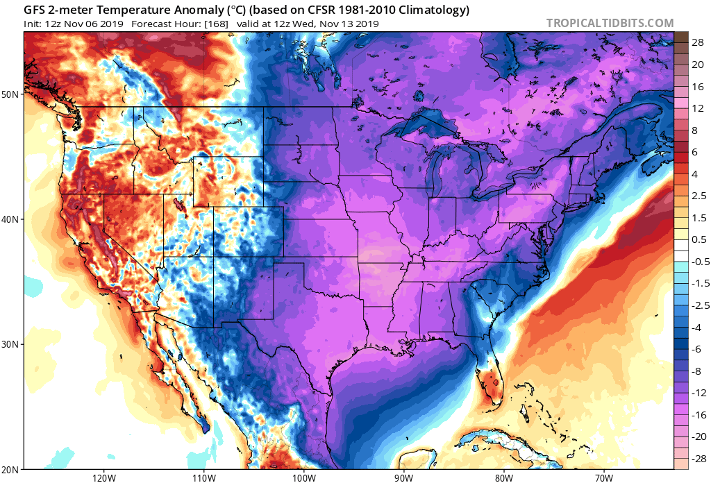
0 likes

-
gatorcane
- S2K Supporter
- Posts: 23499
- Age: 46
- Joined: Sun Mar 13, 2005 3:54 pm
- Location: Boca Raton, FL
Re: Florida Weather
canes92 wrote:Does it stop right at I-4?
Looks like it, winds turn NE behind the front which keeps the east coast warmer than the west coast, plus looks like some lingering cloud cover. Still SE Florida would feel cool with highs barely making it into the 70sF.
CMC has trended colder for all of Florida by the way.
0 likes
Re: Florida Weather
And the 12z Euro folds to the latest 12z GFS, much colder run for the FL Peninsula in the 7-10 day range, at least for now.
Edit: It now shows lows in the upper 40s across the I-4 corridor for Wednesday AM and highs only near 60 F.
Lows in the mid to upper 50s for most of S FL with highs only in the low to mid 70s.
Edit: It now shows lows in the upper 40s across the I-4 corridor for Wednesday AM and highs only near 60 F.
Lows in the mid to upper 50s for most of S FL with highs only in the low to mid 70s.
0 likes
-
northjaxpro
- S2K Supporter
- Posts: 8900
- Joined: Mon Sep 27, 2010 11:21 am
- Location: Jacksonville, FL
Re: Florida Weather
0 likes
NEVER, EVER SAY NEVER in the tropics and weather in general, and most importantly, with life itself!!
________________________________________________________________________________________
Fay 2008 Beryl 2012 Debby 2012 Colin 2016 Hermine 2016 Julia 2016 Matthew 2016 Irma 2017 Dorian 2019
________________________________________________________________________________________
Fay 2008 Beryl 2012 Debby 2012 Colin 2016 Hermine 2016 Julia 2016 Matthew 2016 Irma 2017 Dorian 2019
Re: Florida Weather
northjaxpro wrote::uarrow: Yes indeed NDG. EURO and CMC joining the GFS with colder trend as I anticipated and explained earlier in my post this morning....
But the GFS dropped its earlier frozen precip forecast runs for parts of the north central gulf coast.
0 likes
-
northjaxpro
- S2K Supporter
- Posts: 8900
- Joined: Mon Sep 27, 2010 11:21 am
- Location: Jacksonville, FL
Re: Florida Weather
NDG wrote:northjaxpro wrote::uarrow: Yes indeed NDG. EURO and CMC joining the GFS with colder trend as I anticipated and explained earlier in my post this morning....
But the GFS dropped its earlier frozen precip forecast runs for parts of the north central gulf coast.
Yeah I caught that as well.
0 likes
NEVER, EVER SAY NEVER in the tropics and weather in general, and most importantly, with life itself!!
________________________________________________________________________________________
Fay 2008 Beryl 2012 Debby 2012 Colin 2016 Hermine 2016 Julia 2016 Matthew 2016 Irma 2017 Dorian 2019
________________________________________________________________________________________
Fay 2008 Beryl 2012 Debby 2012 Colin 2016 Hermine 2016 Julia 2016 Matthew 2016 Irma 2017 Dorian 2019
-
HurricaneBelle

- S2K Supporter
- Posts: 975
- Joined: Sun Aug 27, 2006 6:12 pm
- Location: Clearwater, FL
Re: Florida Weather
Looks like I'm going to have to dress warmly a week from Friday when I take my son on his tour of UF.
0 likes
-
Hypercane_Kyle

- Category 5
- Posts: 2900
- Joined: Sat Mar 07, 2015 7:58 pm
- Location: Cape Canaveral, FL
Re: Florida Weather
That's quite a sharp gradient over NFL.

0 likes
My posts are my own personal opinion, defer to the National Hurricane Center (NHC) and other NOAA products for decision making during hurricane season.
Re: Florida Weather
The latest 0z Euro went back to its earlier warmer solutions for morning lows next week, only in the upper 50s to low 60s for the I-4 corridor Wednesday and Thursday mornings, but it still shows cool daytime highs for Wednesday staying 60s across most of central FL with lingering cloud cover.
The latest 06z GFS has also backed out, it now shows freezing temps only for the western FL Panhandle, lows in the upper 30s & 40s for the rest of N FL.
The latest 06z GFS has also backed out, it now shows freezing temps only for the western FL Panhandle, lows in the upper 30s & 40s for the rest of N FL.
0 likes
-
northjaxpro
- S2K Supporter
- Posts: 8900
- Joined: Mon Sep 27, 2010 11:21 am
- Location: Jacksonville, FL
Re: Florida Weather
Models the.last couple of runs have been hintng at some cloud cover from the Southern Stream Jet that could keep us from getting to freezing here in Northeast Florida on Wednesday and Thursday morning of next week. This is probably likelythe GFS indeed is picking up on with the temp forecast going into about a week from now.
EDIT: Yes, the 06Z GFS shows a 1007 mb Low Pressure area moving out of the GOM and across North Florida on next Thursday and and moving offshore off the SE US Atlantic coast, which is a BIG change from yesterday's runs. We may have a potential heavy rain and severe storm event here on next Thursday. We eill have to see how this is handled in future runs the next few days. I mentioned earlier in the week that the GFS and CMC may be hinting at an active Southern Stream Jet next week on the Deep South Thread and indeed that may come to fruition.
EDIT: Yes, the 06Z GFS shows a 1007 mb Low Pressure area moving out of the GOM and across North Florida on next Thursday and and moving offshore off the SE US Atlantic coast, which is a BIG change from yesterday's runs. We may have a potential heavy rain and severe storm event here on next Thursday. We eill have to see how this is handled in future runs the next few days. I mentioned earlier in the week that the GFS and CMC may be hinting at an active Southern Stream Jet next week on the Deep South Thread and indeed that may come to fruition.
0 likes
NEVER, EVER SAY NEVER in the tropics and weather in general, and most importantly, with life itself!!
________________________________________________________________________________________
Fay 2008 Beryl 2012 Debby 2012 Colin 2016 Hermine 2016 Julia 2016 Matthew 2016 Irma 2017 Dorian 2019
________________________________________________________________________________________
Fay 2008 Beryl 2012 Debby 2012 Colin 2016 Hermine 2016 Julia 2016 Matthew 2016 Irma 2017 Dorian 2019

-
northjaxpro
- S2K Supporter
- Posts: 8900
- Joined: Mon Sep 27, 2010 11:21 am
- Location: Jacksonville, FL
Re: Florida Weather
The next few models runs will be interesting NDG to say to the least.
0 likes
NEVER, EVER SAY NEVER in the tropics and weather in general, and most importantly, with life itself!!
________________________________________________________________________________________
Fay 2008 Beryl 2012 Debby 2012 Colin 2016 Hermine 2016 Julia 2016 Matthew 2016 Irma 2017 Dorian 2019
________________________________________________________________________________________
Fay 2008 Beryl 2012 Debby 2012 Colin 2016 Hermine 2016 Julia 2016 Matthew 2016 Irma 2017 Dorian 2019
Return to “USA & Caribbean Weather”
Who is online
Users browsing this forum: cstrunk and 20 guests