Page 19 of 112

Re: Texas Fall 2018

Posted: Fri Sep 21, 2018 1:57 pm
by Ntxw
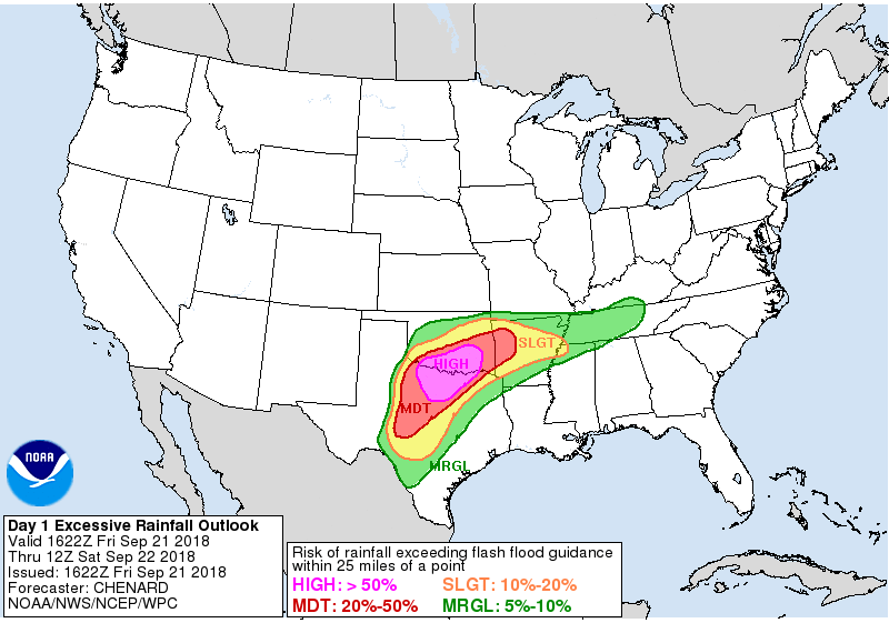
You don't see this everyday outside of a land-falling tropical system.
Image

Excessive Rainfall Discussion
NWS Weather Prediction Center College Park MD
1223 PM EDT Fri Sep 21 2018

Day 1
Valid 1622Z Fri Sep 21 2018 - 12Z Sat Sep 22 2018

...THERE IS A HIGH RISK OF EXCESSIVE RAINFALL OVER PORTIONS OF THE
SOUTHERN PLAINS...

...Significant and locally life-threatening flash flood event
underway across portions of northern TX and southern OK...

16z Update: Decision was made to upgrade to a HIGH risk of
excessive rainfall across portions of northern TX into southern
OK. Given recent radar trends, observations thus far suggesting
very efficient tropical rainfall processes at play, and 12z
HREF/HRRR guidance...pockets of 6-10" of rain appear likely across
the HIGH risk area today into tonight. The highest threat is
focused along and south of the nearly stationary west to east
convective line stretching across southern OK as of 16z. Expect
convection to continue to develop into this boundary from the
south as the low over west TX slowly pushes east. Convection will
eventually expand southward into north TX ahead of this low...with
slow moving/training likely here as well as we head through the
day into tonight. See the latest MPD for the most up to date
information. -Chenard
Re: Texas Fall 2018

Posted: Fri Sep 21, 2018 2:07 pm
by funster
Some impressive early downpours in north Dallas already. Sun is back out again temporarily. Very steamy.

Re: Texas Fall 2018

Posted: Fri Sep 21, 2018 2:14 pm
by Yukon Cornelius
Driving to Wichita KS today and drove through the heaviest constant downpour that never let up through most of the Oklahoma. I really don’t remember if I’ve ever seen rain this heavy for this long before. Flood warnings up this way everywhere.

Re: Texas Fall 2018

Posted: Fri Sep 21, 2018 3:29 pm
by rwfromkansas
Wow, high risk appears to go into western Tarrant even.

Re: Texas Fall 2018

Posted: Fri Sep 21, 2018 3:46 pm
by funster
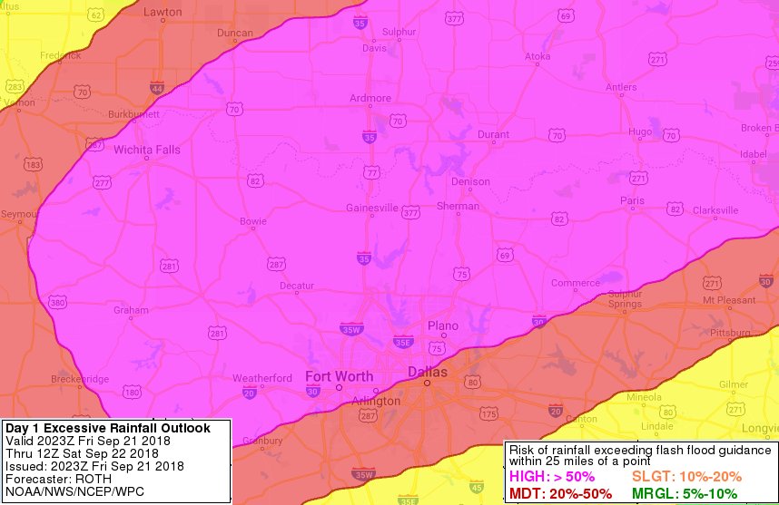
They upgraded the outlook with a larger high risk area of 6-10 inches
https://www.wpc.ncep.noaa.gov/qpf/ero.p ... curr&day=1

Image

Day 1
Valid 1622Z Fri Sep 21 2018 - 12Z Sat Sep 22 2018

...THERE IS A HIGH RISK OF EXCESSIVE RAINFALL OVER PORTIONS OF THE
SOUTHERN PLAINS...

...Significant and locally life-threatening flash flood event
underway across portions of northern TX and southern OK...

16z Update: Decision was made to upgrade to a HIGH risk of
excessive rainfall across portions of northern TX into southern
OK. Given recent radar trends, observations thus far suggesting
very efficient tropical rainfall processes at play, and 12z
HREF/HRRR guidance...pockets of 6-10" of rain appear likely across
the HIGH risk area today into tonight. The highest threat is
focused along and south of the nearly stationary west to east
convective line stretching across southern OK as of 16z. Expect
convection to continue to develop into this boundary from the
south as the low over west TX slowly pushes east. Convection will
eventually expand southward into north TX ahead of this low...with
slow moving/training likely here as well as we head through the
day into tonight. See the latest MPD for the most up to date
information. -Chenard

Re: Texas Fall 2018

Posted: Fri Sep 21, 2018 3:53 pm
by rwfromkansas
Grew up north of there. Miss those Nu-Way loose meat burgers. Be safe.
Yukon Cornelius wrote:Driving to Wichita KS today and drove through the heaviest constant downpour that never let up through most of the Oklahoma. I really don’t remember if I’ve ever seen rain this heavy for this long before. Flood warnings up this way everywhere.

Re: Texas Fall 2018

Posted: Fri Sep 21, 2018 4:14 pm
by rwfromkansas
Do they have the rainfall outlooks with county borders? Have to zoom in to see close enough.

Re: Texas Fall 2018

Posted: Fri Sep 21, 2018 4:40 pm
by TarrantWx
Some of these isolated cells seem to be taking on that supercellular flying eagle look occasionally

Re: Texas Fall 2018

Posted: Fri Sep 21, 2018 5:14 pm
by Ntxw
Some fact tweets from the WPC. Just to remind us we are amidst the EPAC re-curve season, while a Nino is trying to turn on.

 https://twitter.com/NWSWPC/status/1043244698914250753


Re: Texas Fall 2018

Posted: Fri Sep 21, 2018 6:22 pm
by bubba hotep
18z 3k NAM with a 20"+ rain bomb over Collin County

Image

Re: Texas Fall 2018

Posted: Fri Sep 21, 2018 6:26 pm
by rwfromkansas
I am on the edge of a storm so am getting on and off quick bursts of rain. Very heavy when it happens. Very...

Re: Texas Fall 2018

Posted: Fri Sep 21, 2018 6:29 pm
by Ntxw
Currently 77F with 75 dewpoint. I believe this is Aruba.

Re: Texas Fall 2018

Posted: Fri Sep 21, 2018 7:11 pm
by bubba hotep
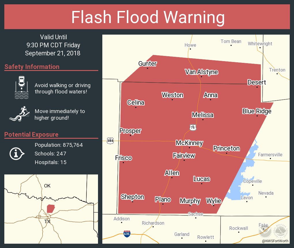
New WPC Meso Discussion

Image


Mesoscale Precipitation Discussion 0875
NWS Weather Prediction Center College Park MD
751 PM EDT Fri Sep 21 2018

Areas affected...Southern OK...North Central TX

Concerning...Heavy rainfall...Flash flooding likely

Valid 212350Z - 220550Z

Summary...Dangerous flash flooding will continue across areas of
southern Oklahoma while expanding into north-central Texas through
the evening hours. Additional rainfall totals of 3 to 5 inches
with locally higher amounts will continue the high risk of flash
flooding.

Discussion...A strong setup continues for slow-moving convection
in a highly efficient and moist airmass across southern Oklahoma
and central Texas. Aloft, there is a broad area of divergence
across the region while at the surface, a low was analyzed near
KABI with a stationary draped across northern Texas near the Red
River into west-central Arkansas. GOES-16 satellite imagery
depicted a mid-level low across west-central Texas which is
facilitating this forcing aloft.

Sufficient instability exists across Texas with MLCAPE values of
1000 to 2000 J/kg northward to the Red River. Impinging on the
surface boundary is highly anomalous moisture from the Gulf of
Mexico where recent RAP mesoanalysis showed PWATs of 2.2 to 2.3
inches, which is nearly 3 SD above normal. Strong 850mb moisture
transport overrunning the stationary boundary has led to west/east
oriented bands of convection since earlier this morning. Observed
totals across southern Oklahoma generally show widespread areal
averages of 3 to 6 inches with local pockets of 7 to 10 inches.
The highest total observed so far as of 7 pm EDT is 15.50 inches
just south of Stonewall, OK as reported by emergency managers.

There is good consensus in the recent runs of the HRRR and other
CAMs depicting convection will continue slowly shifting from
southern Oklahoma into north-central Texas as the surface low
drifts eastward. This should set up a localized area of strong
convergence, and given a continued influx of moisture, very
efficient rainfall will persist through the evening hours.
Forecast soundings for the Dallas/Ft. Worth area depict
tall/skinny profiles with near saturation all supporting the
tropical moisture allowing for efficient rainfall. Latest runs of
the RAP show warm cloud depths of 4.5 to 5 km continuing through
the evening hours. Over the next several hours, there is good
agreement for an additional 3 to 5 inches of rain across
north-central Texas with locally higher amounts likely. This will
include the Dallas/Ft. Worth metropolitan area.

These ingredients all suggest life-threatening and dangerous flash
flooding will continue in the short-term across southern Oklahoma,
but will likely expand across north-central Texas through the
evening and into the overnight hours.

Taylor

ATTN...WFO...EWX...FWD...OUN...SHV...SJT...TSA...

ATTN...RFC...ABRFC...LMRFC...WGRFC...

Re: Texas Fall 2018

Posted: Fri Sep 21, 2018 7:24 pm
by bubba hotep
Image

Re: Texas Fall 2018

Posted: Fri Sep 21, 2018 7:28 pm
by bubba hotep
Image

Re: Texas Fall 2018

Posted: Fri Sep 21, 2018 7:44 pm
by Brent
Well its here and it may not stop all night :double: ridiculous rates

Somebody is gonna get a foot easy

Re: Texas Fall 2018

Posted: Fri Sep 21, 2018 8:16 pm
by Haris
Image

Attention austin friends , could have some issues tonight . hrrr painting 6" western austin

Re: Texas Fall 2018

Posted: Fri Sep 21, 2018 8:28 pm
by bubba hotep
Brent wrote:Well its here and it may not stop all night :double: ridiculous rates

Somebody is gonna get a foot easy


I think rates are even higher with this wave!

Re: Texas Fall 2018

Posted: Fri Sep 21, 2018 8:39 pm
by bubba hotep
The HRRR is really doing poorly with this system tonight across DFW.

Re: Texas Fall 2018

Posted: Fri Sep 21, 2018 8:40 pm
by Brent
bubba hotep wrote:
Brent wrote:Well its here and it may not stop all night :double: ridiculous rates

Somebody is gonna get a foot easy


I think rates are even higher with this wave!


This is crazy i bet my rain gauge will be overflowing soon after i get off work at 10