Texas Spring 2021
Moderator: S2k Moderators
Forum rules

The posts in this forum are NOT official forecast and should not be used as such. They are just the opinion of the poster and may or may not be backed by sound meteorological data. They are NOT endorsed by any professional institution or STORM2K.

Re: Texas Spring 2021
Dime sized hail and some serious gusts and sheeting rain here in Plano/Parker. Hail buildup in yard.
1 likes
...I am here in this critical ocean to kill whales for my living, and not to be killed by them for theirs...
E Plano
E Plano
-
bubba hotep

- S2K Supporter

- Posts: 5533
- Joined: Wed Dec 28, 2016 1:00 am
- Location: Collin County Texas
Re: Texas Spring 2021
Looks like we got a tornado outside the watch box and a few svr warned cells as well.
0 likes
Winter time post are almost exclusively focused on the DFW area.
-
jasons2k

- Storm2k Executive

- Posts: 8083
- Age: 50
- Joined: Wed Jul 06, 2005 12:32 pm
- Location: The Woodlands, TX
Re: Texas Spring 2021
BULLETIN - EAS ACTIVATION REQUESTED
Tornado Warning
National Weather Service Houston/Galveston TX
545 PM CDT Fri Apr 23 2021
The National Weather Service in League City has issued a
* Tornado Warning for...
East central Montgomery County in southeastern Texas...
Southwestern San Jacinto County in southeastern Texas...
Northwestern Liberty County in southeastern Texas...
* Until 615 PM CDT.
* At 545 PM CDT, a severe thunderstorm capable of producing a tornado
was located near Cut And Shoot, or near Conroe, moving east at 35
mph.
HAZARD...Tornado and quarter size hail.
SOURCE...Radar indicated rotation.
IMPACT...Flying debris will be dangerous to those caught without
shelter. Mobile homes will be damaged or destroyed.
Damage to roofs, windows, and vehicles will occur. Tree
damage is likely.
* This tornadic thunderstorm will remain over mainly rural areas of
east central Montgomery, southwestern San Jacinto and northwestern
Liberty Counties.
PRECAUTIONARY/PREPAREDNESS ACTIONS...
TAKE COVER NOW! Move to a basement or an interior room on the lowest
floor of a sturdy building. Avoid windows. If you are outdoors, in a
mobile home, or in a vehicle, move to the closest substantial shelter
and protect yourself from flying debris.
0 likes
-
ElectricStorm

- Category 5

- Posts: 4603
- Age: 23
- Joined: Tue Aug 13, 2019 11:23 pm
- Location: Skiatook, OK / Norman, OK
Re: Texas Spring 2021
Confirmed tornado south of Quanah
0 likes
I am in no way a professional. Take what I say with a grain of salt as I could be totally wrong. Please refer to the NHC, NWS, or SPC for official information.
Boomer Sooner!
Boomer Sooner!
-
Iceresistance

- Category 5
- Posts: 8925
- Age: 20
- Joined: Sat Oct 10, 2020 9:45 am
- Location: Tecumseh, OK/Norman, OK
Re: Texas Spring 2021
Baseball sized hail reported near Truscott, TX
0 likes
Bill 2015 & Beta 2020
Winter 2020-2021
All observations are in Tecumseh, OK unless otherwise noted.
Winter posts are focused mainly for Oklahoma & Texas.
Take any of my forecasts with a grain of salt, refer to the NWS, SPC, and NHC for official information
Never say Never with weather! Because ANYTHING is possible!
Winter 2020-2021
All observations are in Tecumseh, OK unless otherwise noted.
Winter posts are focused mainly for Oklahoma & Texas.
Take any of my forecasts with a grain of salt, refer to the NWS, SPC, and NHC for official information
Never say Never with weather! Because ANYTHING is possible!
-
Iceresistance
- Category 5
- Posts: 8925
- Age: 20
- Joined: Sat Oct 10, 2020 9:45 am
- Location: Tecumseh, OK/Norman, OK
Re: Texas Spring 2021
Tornado reported near Turkey, TX
0 likes
Bill 2015 & Beta 2020
Winter 2020-2021
All observations are in Tecumseh, OK unless otherwise noted.
Winter posts are focused mainly for Oklahoma & Texas.
Take any of my forecasts with a grain of salt, refer to the NWS, SPC, and NHC for official information
Never say Never with weather! Because ANYTHING is possible!
Winter 2020-2021
All observations are in Tecumseh, OK unless otherwise noted.
Winter posts are focused mainly for Oklahoma & Texas.
Take any of my forecasts with a grain of salt, refer to the NWS, SPC, and NHC for official information
Never say Never with weather! Because ANYTHING is possible!
-
Iceresistance
- Category 5
- Posts: 8925
- Age: 20
- Joined: Sat Oct 10, 2020 9:45 am
- Location: Tecumseh, OK/Norman, OK
Re: Texas Spring 2021
Tornadic Supercell that is producing tornadoes is heading straight for Vernon, TX!
If you live In or West of Vernon, TX . . . GET DOWN NOW! THIS IS A PARTICULARLY DANGEROUS SITUATION!
If you live In or West of Vernon, TX . . . GET DOWN NOW! THIS IS A PARTICULARLY DANGEROUS SITUATION!
0 likes
Bill 2015 & Beta 2020
Winter 2020-2021
All observations are in Tecumseh, OK unless otherwise noted.
Winter posts are focused mainly for Oklahoma & Texas.
Take any of my forecasts with a grain of salt, refer to the NWS, SPC, and NHC for official information
Never say Never with weather! Because ANYTHING is possible!
Winter 2020-2021
All observations are in Tecumseh, OK unless otherwise noted.
Winter posts are focused mainly for Oklahoma & Texas.
Take any of my forecasts with a grain of salt, refer to the NWS, SPC, and NHC for official information
Never say Never with weather! Because ANYTHING is possible!
-
Texas Snowman

- Storm2k Moderator

- Posts: 6041
- Joined: Fri Jan 25, 2008 11:29 am
- Location: Denison, Texas
Re: Texas Spring 2021
459
WFUS54 KOUN 232318
TOROUN
TXC155-197-487-240000-
/O.NEW.KOUN.TO.W.0008.210423T2318Z-210424T0000Z/
BULLETIN - EAS ACTIVATION REQUESTED
Tornado Warning
National Weather Service Norman OK
618 PM CDT Fri Apr 23 2021
The National Weather Service in Norman has issued a
* Tornado Warning for...
Northeastern Foard County in northern Texas...
West central Wilbarger County in northern Texas...
Southeastern Hardeman County in northern Texas...
* Until 700 PM CDT.
* At 618 PM CDT, a confirmed large and extremely dangerous tornado
was located 5 miles west of Lockett, moving east at 25 mph.
This is a PARTICULARLY DANGEROUS SITUATION. TAKE COVER NOW!
HAZARD...Damaging tornado.
SOURCE...Weather spotters confirmed tornado.
IMPACT...You are in a life-threatening situation. Flying debris
may be deadly to those caught without shelter. Mobile
homes will be destroyed. Considerable damage to homes,
businesses, and vehicles is likely and complete
destruction is possible.
* Locations impacted include...
Vernon, Lockett and Rayland.
PRECAUTIONARY/PREPAREDNESS ACTIONS...
To repeat, an extremely dangerous and potentially deadly tornado is
on the ground. To protect your life, TAKE COVER NOW! Move to a storm
shelter, safe room or an interior room on the lowest floor of a
sturdy building. Avoid windows. If you are outdoors, in a mobile
home, or in a vehicle, move to the closest substantial shelter and
protect yourself from flying debris.
&&
LAT...LON 3404 9955 3424 9955 3425 9920 3402 9920
TIME...MOT...LOC 2318Z 270DEG 23KT 3415 9946
TORNADO...OBSERVED
TORNADO DAMAGE THREAT...CONSIDERABLE
HAIL...1.75IN
$$
0 likes
The above post and any post by Texas Snowman is NOT an official forecast and should not be used as such. It is just the opinion of the poster and may or may not be backed by sound meteorological data. It is NOT endorsed by any professional institution including storm2k.org. For official information, please refer to NWS products.
-
Yukon Cornelius
- S2K Supporter
- Posts: 1738
- Age: 40
- Joined: Thu Dec 20, 2012 9:23 pm
- Location: Dean, TX/Westcliffe, CO
Re: Texas Spring 2021
Texas Snowman wrote:459
WFUS54 KOUN 232318
TOROUN
TXC155-197-487-240000-
/O.NEW.KOUN.TO.W.0008.210423T2318Z-210424T0000Z/
BULLETIN - EAS ACTIVATION REQUESTED
Tornado Warning
National Weather Service Norman OK
618 PM CDT Fri Apr 23 2021
The National Weather Service in Norman has issued a
* Tornado Warning for...
Northeastern Foard County in northern Texas...
West central Wilbarger County in northern Texas...
Southeastern Hardeman County in northern Texas...
* Until 700 PM CDT.
* At 618 PM CDT, a confirmed large and extremely dangerous tornado
was located 5 miles west of Lockett, moving east at 25 mph.
This is a PARTICULARLY DANGEROUS SITUATION. TAKE COVER NOW!
HAZARD...Damaging tornado.
SOURCE...Weather spotters confirmed tornado.
IMPACT...You are in a life-threatening situation. Flying debris
may be deadly to those caught without shelter. Mobile
homes will be destroyed. Considerable damage to homes,
businesses, and vehicles is likely and complete
destruction is possible.
* Locations impacted include...
Vernon, Lockett and Rayland.
PRECAUTIONARY/PREPAREDNESS ACTIONS...
To repeat, an extremely dangerous and potentially deadly tornado is
on the ground. To protect your life, TAKE COVER NOW! Move to a storm
shelter, safe room or an interior room on the lowest floor of a
sturdy building. Avoid windows. If you are outdoors, in a mobile
home, or in a vehicle, move to the closest substantial shelter and
protect yourself from flying debris.
&&
LAT...LON 3404 9955 3424 9955 3425 9920 3402 9920
TIME...MOT...LOC 2318Z 270DEG 23KT 3415 9946
TORNADO...OBSERVED
TORNADO DAMAGE THREAT...CONSIDERABLE
HAIL...1.75IN
$$
Out towards my neck of the woods....great.
0 likes
#neversummer
-
Iceresistance
- Category 5
- Posts: 8925
- Age: 20
- Joined: Sat Oct 10, 2020 9:45 am
- Location: Tecumseh, OK/Norman, OK
Re: Texas Spring 2021
3.5 inch Hail has been reported near Gilliland, TX
0 likes
Bill 2015 & Beta 2020
Winter 2020-2021
All observations are in Tecumseh, OK unless otherwise noted.
Winter posts are focused mainly for Oklahoma & Texas.
Take any of my forecasts with a grain of salt, refer to the NWS, SPC, and NHC for official information
Never say Never with weather! Because ANYTHING is possible!
Winter 2020-2021
All observations are in Tecumseh, OK unless otherwise noted.
Winter posts are focused mainly for Oklahoma & Texas.
Take any of my forecasts with a grain of salt, refer to the NWS, SPC, and NHC for official information
Never say Never with weather! Because ANYTHING is possible!
-
rwfromkansas
- Category 5
- Posts: 2230
- Joined: Sat Aug 27, 2005 12:47 am
- Location: North Fort Worth
Re: Texas Spring 2021
DFW and a weird collection of counties removed from a watch. Guess no round later. Got .05 today.
0 likes
-
Iceresistance
- Category 5
- Posts: 8925
- Age: 20
- Joined: Sat Oct 10, 2020 9:45 am
- Location: Tecumseh, OK/Norman, OK
Re: Texas Spring 2021
Yukon Cornelius wrote:Texas Snowman wrote:459
WFUS54 KOUN 232318
TOROUN
TXC155-197-487-240000-
/O.NEW.KOUN.TO.W.0008.210423T2318Z-210424T0000Z/
BULLETIN - EAS ACTIVATION REQUESTED
Tornado Warning
National Weather Service Norman OK
618 PM CDT Fri Apr 23 2021
The National Weather Service in Norman has issued a
* Tornado Warning for...
Northeastern Foard County in northern Texas...
West central Wilbarger County in northern Texas...
Southeastern Hardeman County in northern Texas...
* Until 700 PM CDT.
* At 618 PM CDT, a confirmed large and extremely dangerous tornado
was located 5 miles west of Lockett, moving east at 25 mph.
This is a PARTICULARLY DANGEROUS SITUATION. TAKE COVER NOW!
HAZARD...Damaging tornado.
SOURCE...Weather spotters confirmed tornado.
IMPACT...You are in a life-threatening situation. Flying debris
may be deadly to those caught without shelter. Mobile
homes will be destroyed. Considerable damage to homes,
businesses, and vehicles is likely and complete
destruction is possible.
* Locations impacted include...
Vernon, Lockett and Rayland.
PRECAUTIONARY/PREPAREDNESS ACTIONS...
To repeat, an extremely dangerous and potentially deadly tornado is
on the ground. To protect your life, TAKE COVER NOW! Move to a storm
shelter, safe room or an interior room on the lowest floor of a
sturdy building. Avoid windows. If you are outdoors, in a mobile
home, or in a vehicle, move to the closest substantial shelter and
protect yourself from flying debris.
&&
LAT...LON 3404 9955 3424 9955 3425 9920 3402 9920
TIME...MOT...LOC 2318Z 270DEG 23KT 3415 9946
TORNADO...OBSERVED
TORNADO DAMAGE THREAT...CONSIDERABLE
HAIL...1.75IN
$$
Out towards my neck of the woods....great.
Is there a chance that you might see it?
If so, try to take a photo before getting into the Storm Shelter . . .
Unless the tornado is TOO CLOSE!
0 likes
Bill 2015 & Beta 2020
Winter 2020-2021
All observations are in Tecumseh, OK unless otherwise noted.
Winter posts are focused mainly for Oklahoma & Texas.
Take any of my forecasts with a grain of salt, refer to the NWS, SPC, and NHC for official information
Never say Never with weather! Because ANYTHING is possible!
Winter 2020-2021
All observations are in Tecumseh, OK unless otherwise noted.
Winter posts are focused mainly for Oklahoma & Texas.
Take any of my forecasts with a grain of salt, refer to the NWS, SPC, and NHC for official information
Never say Never with weather! Because ANYTHING is possible!

Re: Texas Spring 2021
rwfromkansas wrote:DFW and a weird collection of counties removed from a watch. Guess no round later. Got .05 today.
Yep, what a bust for northern Tarrant County.
0 likes
-
Iceresistance
- Category 5
- Posts: 8925
- Age: 20
- Joined: Sat Oct 10, 2020 9:45 am
- Location: Tecumseh, OK/Norman, OK
Re: Texas Spring 2021
You don't hear this often but
3.37 inch Hail was reported near Quanah, TX
3.37 inch Hail was reported near Quanah, TX
0 likes
Bill 2015 & Beta 2020
Winter 2020-2021
All observations are in Tecumseh, OK unless otherwise noted.
Winter posts are focused mainly for Oklahoma & Texas.
Take any of my forecasts with a grain of salt, refer to the NWS, SPC, and NHC for official information
Never say Never with weather! Because ANYTHING is possible!
Winter 2020-2021
All observations are in Tecumseh, OK unless otherwise noted.
Winter posts are focused mainly for Oklahoma & Texas.
Take any of my forecasts with a grain of salt, refer to the NWS, SPC, and NHC for official information
Never say Never with weather! Because ANYTHING is possible!
-
HockeyTx82
- S2K Supporter
- Posts: 2014
- Joined: Tue Oct 27, 2009 11:17 am
- Location: Ponder, TX
Re: Texas Spring 2021
So that Tornado warned storm NE of Denton was acting kinda odd out here over Ponder. It moved off to the NE and went Tor Warn. I called NWS with what I saw in Ponder. Sounds like it was getting it's act going here and went on about Tornado just NE of me. Felt some vindication that all those trainings I went to paid off.
Last edited by HockeyTx82 on Fri Apr 23, 2021 7:08 pm, edited 1 time in total.
3 likes
Don't hold me accountable for anything I post on this forum. Leave the real forecasting up to the professionals.
Location: Ponder, TX (all observation posts are this location unless otherwise noted)
Location: Ponder, TX (all observation posts are this location unless otherwise noted)
-
Iceresistance
- Category 5
- Posts: 8925
- Age: 20
- Joined: Sat Oct 10, 2020 9:45 am
- Location: Tecumseh, OK/Norman, OK
Re: Texas Spring 2021
Radar is showing potentially early stages of a Squall Line developing in SW Oklahoma . . . 
Last edited by Iceresistance on Fri Apr 23, 2021 7:06 pm, edited 1 time in total.
0 likes
Bill 2015 & Beta 2020
Winter 2020-2021
All observations are in Tecumseh, OK unless otherwise noted.
Winter posts are focused mainly for Oklahoma & Texas.
Take any of my forecasts with a grain of salt, refer to the NWS, SPC, and NHC for official information
Never say Never with weather! Because ANYTHING is possible!
Winter 2020-2021
All observations are in Tecumseh, OK unless otherwise noted.
Winter posts are focused mainly for Oklahoma & Texas.
Take any of my forecasts with a grain of salt, refer to the NWS, SPC, and NHC for official information
Never say Never with weather! Because ANYTHING is possible!
-
jasons2k
- Storm2k Executive
- Posts: 8083
- Age: 50
- Joined: Wed Jul 06, 2005 12:32 pm
- Location: The Woodlands, TX
Re: Texas Spring 2021
URGENT - IMMEDIATE BROADCAST REQUESTED
Severe Thunderstorm Watch Number 101
NWS Storm Prediction Center Norman OK
705 PM CDT Fri Apr 23 2021
The NWS Storm Prediction Center has issued a
* Severe Thunderstorm Watch for portions of
South central Texas
* Effective this Friday evening from 705 PM until 1100 PM CDT.
* Primary threats include...
Scattered large hail and isolated very large hail events to 2.5
inches in diameter possible
Isolated damaging wind gusts to 70 mph possible
SUMMARY...A few storms now forming near and south of San Antonio may
persist for a few more hours while spreading eastward. The storm
environment will support supercells capable of producing isolated
very large hail and damaging gusts.
The severe thunderstorm watch area is approximately along and 35
statute miles north and south of a line from 35 miles south
southwest of San Antonio TX to 75 miles east of New Braunfels TX.
For a complete depiction of the watch see the associated watch
outline update (WOUS64 KWNS WOU1).
PRECAUTIONARY/PREPAREDNESS ACTIONS...
REMEMBER...A Severe Thunderstorm Watch means conditions are
favorable for severe thunderstorms in and close to the watch area.
Persons in these areas should be on the lookout for threatening
weather conditions and listen for later statements and possible
warnings. Severe thunderstorms can and occasionally do produce
tornadoes.
0 likes
-
bubba hotep
- S2K Supporter
- Posts: 5533
- Joined: Wed Dec 28, 2016 1:00 am
- Location: Collin County Texas
Re: Texas Spring 2021
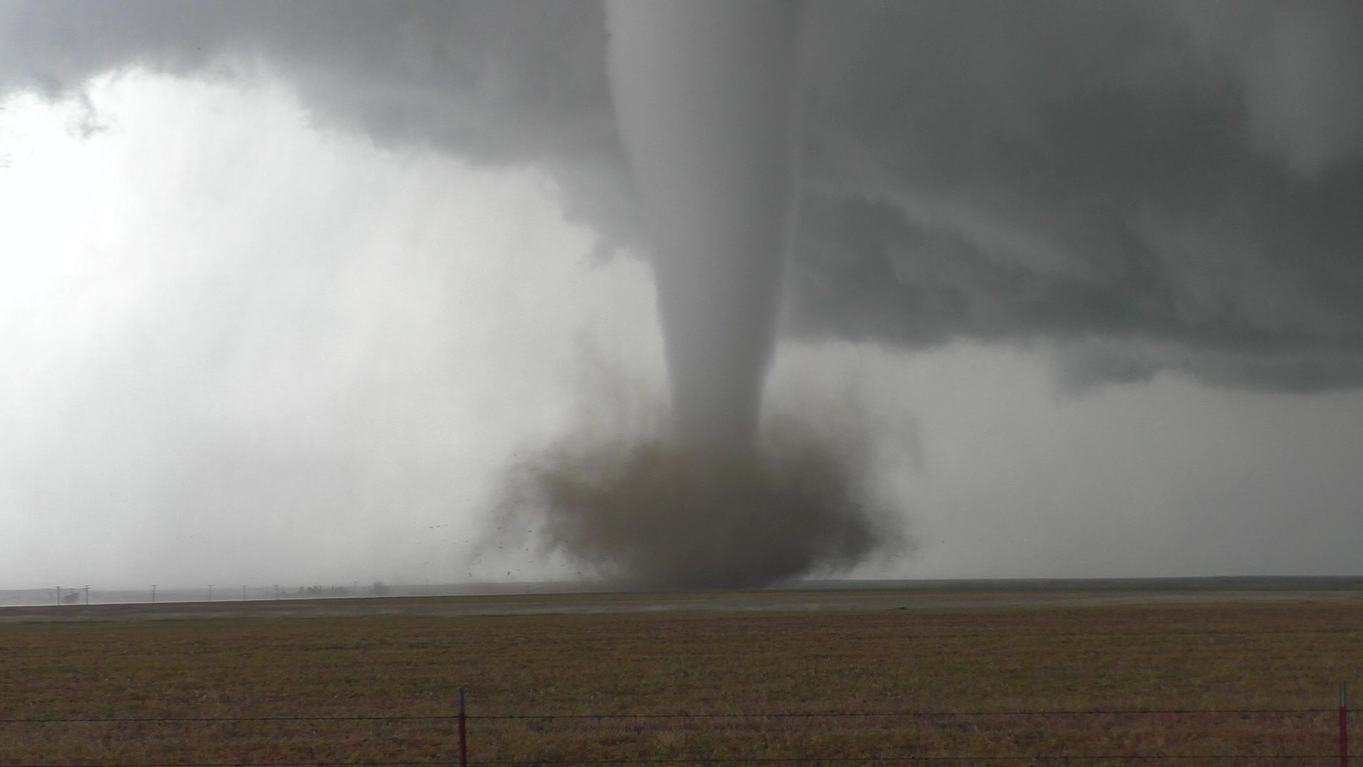
From Brad Arnold @BradArnoldWX of the tornado out by Vernon
4 likes
Winter time post are almost exclusively focused on the DFW area.
-
HockeyTx82
- S2K Supporter
- Posts: 2014
- Joined: Tue Oct 27, 2009 11:17 am
- Location: Ponder, TX
Re: Texas Spring 2021
bubba hotep wrote:From Brad Arnold @BradArnoldWX of the tornado out by Vernon
https://pbs.twimg.com/media/Ezstd4kWYAAB9g5?format=jpg&name=large
She's a pretty one. Nothing more majestic then a twister on the open prairie.
3 likes
Don't hold me accountable for anything I post on this forum. Leave the real forecasting up to the professionals.
Location: Ponder, TX (all observation posts are this location unless otherwise noted)
Location: Ponder, TX (all observation posts are this location unless otherwise noted)
Return to “USA & Caribbean Weather”
Who is online
Users browsing this forum: No registered users and 31 guests