Page 340 of 882
Posted: Sun Feb 05, 2012 11:11 am
by AdamFirst
Largely unsettled pattern is moving in over the next five days or so.

TONIGHT...MOST OF THE SHORT WAVE ENERGY WILL PUSH E OR DISSIPATE
ARND SUNSET. EVEN SO...PERSISTENT SRLY FLOW WILL CONTINUE TO TAP
HIGH MOISTURE OVER THE GOMEX. AIRMASS WILL BCMG NEARLY SATURATED
OVERNIGHT WHILE THE MID LVL SUBSIDENCE INVERSION BREAKS DOWN.
MEANWHILE...A NOTEWORTHY MID LVL ISENTROPIC BNDRY OVER CUBA AND THE
FL STRAITS WILL PUSH ACRS S FL...SETTING THE STAGE FOR A WARM SECTOR
RAIN EVENT. BEST LIFT AND DEEPEST MOISTURE WILL BE OVER THE SRN
CWA...WILL GO WITH INCREASING POPS FROM N TO S. EXTENSIVE CLOUD
COVER AND LIGHT SRLY FLOW WILL KEEP MIN TEMPS IN THE L/M60S...10-15F
ABV AVG.
MON...AMPLE MOISTURE CHANNEL REMAINS OPEN FROM THE SOUTH WITH
UNSETTLED CONDITIONS ASCD WITH A SFC TROUGH LIFTING NWD FROM THE
KEYS AND YUCATAN. SCT POP WITH LOW PRECIP AMOUNTS FORECAST WITH
FEATURE LITING NWD ACROSS AREA DURING MON. OVERNIGHT MINS MILD IN
THE LOW/MID 60S AND DAYTIME HIGHS ON MON RANGING FROM UPR 70S TO
NEAR 80.
TUE-SAT...A WEAK FRONTAL BOUNDARY LOOKS TO MOVE ACROSS A PORTION
OF THE AREA EARLY TUE. ASIDE FROM A SLIGHT CHC OF A COASTAL SHOWER
TUE/TUE NIGHT NE FLOW WILL VEER MORE ONSHORE THROUGH MIDWEEK WITH GUID
CONTINUING TO INDICATE AN APCHG SRN STREAM DISTURBANCE WITH HIGHER
MOISTURE ACROSS GULF REGION COUPLED WITH WAVE EJECTING FROM GULF
PRODUCING HIGHEST RAIN CHCS LATE WED INTO THU. THE FAST MOVING
WAVE WILL PRODUCE NOTEWORTHY RAIN CHCS FOR ONE OR TWO PERIODS...HOWEVER
SPEED OF SYSTEM REMAINS QUESTIONABLE AND THE PERIODS FOR BEST POPS
WL LIKELY BE ADJUSTED AS PSBL SFC GENESIS MAY SLOW FEATURE AS IT
APCHS THE AREA. EXTENDED GUID LESS CERTAIN WITH EURO/GFS KEEPING
MOISTURE/ISENTROPIC CONDITIONS AND PEHAPS STRATIFORM RAIN LOCALLY
INTO SATURDAY. WL NOT INCLUDE MENTIONABLE RAIN AT THIS EARLY TIME.
Re: Florida Weather
Posted: Sun Feb 05, 2012 11:34 am
by Sanibel
If this was August the Gulf would be under a formation alert.
The non-winter continues. 80's every day and comfortable with no chill in a bathing suit at night. I even slept with no covers the other night.
Posted: Sun Feb 05, 2012 12:31 pm
by AdamFirst
From the Storm Prediction Center this morning
FARTHER S...COMPARATIVELY RICH LLVL MOISTURE WAS PRESENT OVER MUCH
OF FL. SEABREEZE/FRONTAL CONVERGENCE AND INCREASING LLVL BUOYANCY
MAY BE ENOUGH FOR A FEW TSTMS OVER NRN/CNTRL FL THIS AFTN. NO SVR
WEATHER IS ANTICIPATED OWING TO MEAGER INSTABILITY.
MEANWHILE...UPR DISTURBANCE HAS BEEN STRENGTHENING OVER THE NW
CARIBBEAN/SCNTRL GULF OF MEXICO. DOWNSTREAM...CONVECTION WAS
INCREASING OVER WRN CUBA AND THE KEYS INVOF SFC REFLECTION/TROUGH.
ALTHOUGH COPIOUS AMOUNTS OF HIGH CLOUD COVER WILL ENVELOPE SRN FL TO
LIMIT HEATING...CONVECTION WILL INCREASE THROUGH TONIGHT WITH AT
LEAST ISOLD TSTM PROBABILITIES. WEAK WIND FIELDS/BUOYANCY WILL
LIMIT SVR RISKS.
And from the hurricane center's tropical weather discussion
GULF OF MEXICO...
A WEAK UPPER LEVEL SHORTWAVE TROUGH IS NOTED ON WATER VAPOR
IMAGERY MOVING NORTHEAST ACROSS THE SE CONUS AND OVER THE
NORTHERN PERIPHERY OF UPPER LEVEL RIDGING LOCATED OVER THE SW
NORTH ATLC...FLORIDA PENINSULA...AND PORTIONS OF THE EASTERN
GULF. AS THIS UPPER LEVEL FEATURE HAS MOVED EASTWARD THROUGH THE
OVERNIGHT HOURS...A REMAINING SURFACE FRONT ANALYZED AS A COLD
FRONT FROM 29N91W TO 26N96W TO 22N98W REMAINS NEARLY STATIONARY
AS OF 05/0900 UTC WITH NUMEROUS SHOWERS AND TSTMS OCCURRING IN
THE VICINITY OF THE FRONT...AND OVER THE WESTERN GULF WATERS N
OF 21N W OF 95W...AND N OF 27N W OF 92W. WINDS NOTED ON AN
EARLIER ASCAT PASS AROUND 05/0402 UTC INDICATED N-NE IN THE
RANGE OF 15 TO 25 KT WEST OF THE FRONT. AS THE FRONT PROGRESSES
EASTWARD THROUGH THE DAY SUNDAY INTO MONDAY DUE TO ANOTHER UPPER
LEVEL TROUGH ACROSS THE DESERT SOUTHWEST...HIGH PRESSURE IS
EXPECTED TO BUILD IN BEHIND THE FRONT...WITH THE NORTHERLY WIND
FIELD FORECAST TO EXTEND OVER MUCH OF THE WESTERN GULF WATERS W
OF 90W THROUGH EARLY MONDAY. EAST OF THE FRONTAL BOUNDARY...A
SHARP UPPER LEVEL TROUGH AXIS EXTENDS FROM 23N90W TO A BASE OVER
PANAMA IN CENTRAL AMERICA. UPPER LEVEL DIFFLUENCE IS MAXIMIZED E
OF 90W WITH A SURFACE TROUGH ANALYZED FROM THE NORTHEASTERN TIP
OF THE YUCATAN PENINSULA NEAR 21N87W TO 27N88W. LOW-LEVEL
CONVERGENCE IN THE VICINITY OF THE SURFACE TROUGH ALONG WITH
ENHANCED MIDDLE TO UPPER LEVEL LIFT IS GENERATING SCATTERED
SHOWERS AND ISOLATED TSTMS S OF 27N BETWEEN 80W-89W. WITH THE
APPROACHING FRONT FORECAST TO REACH THE EASTERN GULF BY
MONDAY...THE SURFACE TROUGHING IS EXPECTED TO MERGE WITH THE
FRONTAL BOUNDARY AND MOVE EAST OF THE REGION BY TUESDAY.
Posted: Sun Feb 05, 2012 1:20 pm
by northjaxpro
Looking at the model runs, it appears that 90L will likely move over the peninsula within the next 36 hours.
No matter if it develops further, at least some benefcial moisture is heading towards the peninsula.
Posted: Sun Feb 05, 2012 1:57 pm
by northjaxpro
Tampa NWS office AFD issued at 1:40 p.m. Here is an excert regarding 90L
A TROUGH IS IN PLACE ACROSS THE AREA WITH SOME LIGHT SHOWERS
MOVING NORTH INTO THE SOUTHERN COASTAL WATERS THIS AFTERNOON. THE
UPPER SHORTWAVE WITH THE SE GULF LOW WILL BE LIFTING OVER THE AREA
THROUGH MONDAY AS THE SURFACE LOW REMAINS NEAR THE YUCATAN/CUBA
AND WILL ALLOW FOR A 20-30 PERCENT CHANCE OF SHOWERS ACROSS THE
AREA OVERNIGHT AND A 30-50 PERCENT CHANCE FOR MONDAY. THE TROUGH
WILL THEN SHIFT EAST MONDAY NIGHT WITH SOME WEAK HIGH PRESSURE
RIDGING INTO THE AREA FROM THE NW TUESDAY.
Excerpts from the Miami NWS office regarding 90L
WATER VAPOR AND VISIBLE SATELLITE SHOWED A LOW LEVEL TROUGH WITH
DEVELOPING SURFACE LOW IN THE YUCATAN CHANNEL THIS AFTERNOON.
THIS SUBTROPICAL VORT WILL BE MOVING NORTHEASTWARD TOWARDS THE
REGION TONIGHT INTO MONDAY. A VERY COMPLEX SITUATION WILL TAKE
PLACE OVER THE NEXT 24-36 HOURS AS THIS FEATURE MERGES WITH A COLD
FRONT THAT WILL BE MOVING TOWARDS THE REGION. TRAINING SHOWERS AND
ISOLATED THUNDERSTORMS WERE NOTED NEAR KEY WEST...AND THIS ENTIRE
AREA WILL BE SHIFTING TO THE NORTHEAST OVERNIGHT. LOCALLY HEAVY
RAINFALL WILL BE POSSIBLE TONIGHT AND MONDAY ACROSS DEEP SOUTH
FLORIDA AND THE EAST COAST METRO AREAS
ON MONDAY..
THE LOW LEVEL TROUGH IS EXPECTED TO MOVE OVER THE
REGION...WITH LOW PRESSURE OVER THE EASTERN GULF. THE DEEPEST
MOISTURE IS EXPECTED TO MOVE OUT OVER THE GULF BY LATE MONDAY
AFTERNOON...BUT A WEAK FRONTAL BOUNDARY WILL BE MOVING INTO SOUTH
FLORIDA. THIS SHOULD PROVIDE EXTRA LIFT OVER THE REGION. SO
NUMEROUS TO OCCASIONAL SHOWERS AND A FEW THUNDERSTORMS ARE
EXPECTED TO CONTINUE OVER THE REGION. KEPT THE HIGHEST POPS OVER
THE EAST COAST AT 70-90 PERCENT AND SLOWLY CUT BACK TO AROUND 60
PERCENT OVER THE NORTHWEST. RAINFALL ACCUMULATIONS TONIGHT THROUGH
MONDAY NIGHT ARE EXPECTED TO RANGE FROM 1/2 TO 1 INCH OVER THE
NORTHWEST TO 1 TO 2 INCHES ACROSS DEEP SOUTH FLORIDA AND THE EAST
COAST METRO AREAS. LOCALLY HEAVIER AMOUNTS MAY BE POSSIBLE IN
ANY THUNDERSTORMS THAT DEVELOP OR TRAINING STORMS.
Posted: Sun Feb 05, 2012 4:03 pm
by gsytch
Third consecutive 80F plus day under hazy sunshine, even humid today. The beat goes on. I just hope we do not get an arctic snap in a few weeks. There is so much brutal cold up north in Asia. Stay away. I am still picking tomatoes from fall's planting!

Re: Florida Weather
Posted: Sun Feb 05, 2012 7:02 pm
by jinftl
Comparing this winter...so far...in Miami to the 2009/2010 and 2010/2011 winters....where is winter in 2011/2012?
Time is running out.....even in the 2 cold winters that preceded this one, most of the 'cold' was in December and January (although we did see some days in the 60s and nights in the 40s in both Feb and March 2010....no temps below 40 after January in either winter though...)
Winter 2011/2012
High Temps in the 50's: 1
High Temps in the 60's: 3
Low Temps in the 30's: 0
Low Temps in the 40's: 2
Winter 2010/2011
High Temps in the 50's: 3
High Temps in the 60's: 12 (last high in the 60's was 2/12)
Low Temps in the 30's: 3
Low Temps in the 40's: 13 (last low temp in the 40's was 1/29)
Winter 2009/2010
High Temps in the 40's: 1
High Temps in the 50's: 1
High Temps in the 60's: 26
Low Temps in the 30's: 3
Low Temps in the 40's: 17
Posted: Mon Feb 06, 2012 7:33 am
by HURAKAN
RECORD EVENT REPORT
NATIONAL WEATHER SERVICE KEY WEST FL
150 AM EST MON FEB 6 2012
...RECORD DAILY RAINFALL MEASURED AT THE KEY WEST INTERNATIONAL
AIRPORT...
4.34 INCHES OF RAIN WAS RECORDED AT THE KEY WEST INTERNATIONAL
AIRPORT YESTERDAY. THIS CRUSHES THE PREVIOUS DAILY RAINFALL RECORD
FOR FEBRUARY 5TH...WHICH WAS 2.89 INCHES...SET IN 1872...140 YEARS
AGO. THIS ALSO SURPASSES THE KEY WEST INTERNATIONAL AIRPORT`S
WETTEST DAY ON RECORD FOR THE ENTIRE MONTH OF FEBRUARY. THIS WAS
PREVIOUSLY SET ON THE 28TH IN 1954...WHERE 4.04 INCHES FELL IN A
SINGLE 24 HOUR PERIOD. RAINFALL RECORDS FOR KEY WEST DATE BACK TO
1871.
Posted: Mon Feb 06, 2012 4:15 pm
by gsytch
85F on the digital today, and I am hearing thunder in the distance from seabreeze thunderstorms. It was raining when I left work - big drops like summer - BUT there is a cold surge coming down next weekend. Looks like upper 30's possible MOn/Tue AM after all this warmth! Then it is suppose to warm back again. I was waiting for a piece of that Asian cold to come down!
Re: Florida Weather
Posted: Tue Feb 07, 2012 10:49 pm
by Patrick99
Today in South Florida....was it February 7, or June 7? Look at this incredibly June-like discussion out of NWS Miami:
".UPDATE...THUNDERSTORMS ONGOING FROM WESTON TO ALONG THE SAWGRASS
EXPRESSWAY NORTH THROUGH SUNRISE AND TAMARAC. THIS DEVELOPED AS
THE GULF SEA BREEZE MET UP WITH THE EAST COAST SEA BREEZE LEADING
TO CONVERGENCE ACROSS THIS AREA. RADAR ESTIMATES RAIN RATES OF
2"/HR IN THESE HEAVY TSTORMS. THIS ACTIVITY WILL WANE OVER THE
NEXT HOUR OR SO, WITH DRY WEATHER FORECAST FOR THE OVERNIGHT."
Re: Florida Weather
Posted: Wed Feb 08, 2012 6:29 pm
by AdamFirst
Another rain event upcoming with winter making a quick stop late this weekend into Monday.

FRI-SUN...HAVE MADE SIGNIFICANT CHANGES TO THE FORECAST THIS
PERIOD. WHILE CONFIDENCE IS INCREASING THAT A WIDESPREAD RAIN
EVENT MAY OCCUR ACROSS CENT FL...THERE IS NOT AGREEMENT AMONG
THE MODELS AS TO WHEN IT WILL OCCUR. THIS IS DUE TO MODEL HANDLING
OF TIMING/STRENGTH OF A SHORTWAVE TROUGH DIVING SE OVER THE
INTERMOUNTAIN WEST AND ITS INTERACTION WITH 1) A CUTOFF UPPER LOW
OFF BAJA PENINSULA MEXICO AND 2) PIECES OF ENERGY PEELING OFF THE
POLAR VORTEX OVER HUDSON BAY CANADA. HAVE DECIDED TO FAVOR THE
ECMWF AND NAM SOLUTIONS WHICH ARE IN GOOD AGREEMENT SHOWING THE
OLD FRONTAL BOUNDARY RETURNING NORTH WITH ISENTROPIC LIFT
PRODUCING A WIDESPREAD RAIN EVENT FOCUSED ON FRIDAY NIGHT. HAVE
RAISED POPS TO 40 PERCENT AND WOULD NOT BE SURPRISED IF WE NEED TO
RAISE THIS FURTHER AS HPC IS INDICATING WIDESPREAD 0.50 INCH
AMOUNTS. NEITHER MODEL IS SHOWING MUCH SFC LOW DEVELOPMENT OVER
THE GULF OF MEXICO WHICH SHOULD LIMIT THE SEVERE WEATHER THREAT.
THE EVENT MAY START AS EARLY AS FRI AFTERNOON BUT WILL KEEP MOST
OF EC FL DRY FRI FOR NOW.
A COLD FRONT IS FORECAST TO CROSS THE AREA EARLY SATURDAY AND
BRING NOTICEABLY COLDER AND DRIER CONDITIONS AS A POLAR HIGH
BUILDS SOUTH OUT OF CANADA INTO THE PLAINS. THIS COULD GIVE US A
QUICK SHOT OF CONTINENTAL POLAR AIRMASS THIS WEEKEND WITH LOWS
POSSIBLY DIPPING INTO THE UPPER 30S ACROSS LAKE/VOLUSIA SUN
MORNING WITH MAX TEMPS POSSIBLY NOT GETTING OUT OF THE 50S SUNDAY.
DID NOT MAKE SUCH DRASTIC CHANGES TO TEMPS AT THIS POINT BUT
SUCH TEMPS ARE POSSIBLE IF THE ECMWF TRULY VERIFIES.
DAY 3 CONVECTIVE OUTLOOK
NWS STORM PREDICTION CENTER NORMAN OK
0224 AM CST WED FEB 08 2012
VALID 101200Z - 111200Z
REGARDLESS...ANY TSTM POTENTIAL WILL LIKELY BE CONFINED TO SOUTH
FL...AND PERHAPS FAR SOUTH TX ON FRIDAY. FOR SOUTH FL...A FEW STRONG
TSTMS CANNOT BE COMPLETELY RULED OUT LATE FRIDAY/EARLY SATURDAY
ESPECIALLY SHOULD A FASTER/MORE AMPLIFIED SOLUTION MATERIALIZE AS
PER THE 00Z ECMWF /VS THE 00Z NAM AND GFS/. EVEN SO...ANY SEVERE
POTENTIAL APPEARS TOO LIMITED/SPECULATIVE AT THIS JUNCTURE GIVEN THE
AFOREMENTIONED GUIDANCE VARIABILITY AND LIKELIHOOD OF LIMITED
DESTABILIZATION.
Posted: Wed Feb 08, 2012 6:44 pm
by gsytch
Considerably cooler today. Barely hit 70F with a moist seabreeze, but mostly sunny. Rains appear likely for the weekend (figures) and cooler weather with frost for North Florida possible. Tampa Bay is looking more like 45-50F for a morning or two, then warmer weather returns. Spring is right around the corner - I hope! A few more weeks and the cold threat diminishes greatly!

Posted: Wed Feb 08, 2012 8:30 pm
by northjaxpro
Yes, we will have a very brief visit of some winter-like temps mainly during the Sunday -Monday time frame across the northern part of the peninsula. The early projections are for temps to maybe flirt at or slightly below the freezing mark Sunday and Monday morning across the normally colder interior areas i.e.. the Tallahassee airport, and the areas out by the I-75 corridor near the Suwannee River basin. The Jax metro early projected numbers for now are for the mid and upper 30s Sunday and Monday morning. I'll be checking the later model runs to see if they trend colder.
This will not last unfortunately. The upper pattern will go zonal again in this region by late Monday and into Tuesday of next week and we will be back to being a bit above average for temperatures, which has been the case virtually this entire season. So I will try to enjoy this brief cool down when it happens later this weekend.
Posted: Thu Feb 09, 2012 10:59 pm
by northjaxpro
Checking the latest trends from the models tonight and indeed they have trended much colder than 24 hours ago. We may see hard freeze advisories this weekend over portions of the northern peninsula. The latest MOS projections are now calling for mid and upper 20s for the colder interior areas of the Big Bend region and the I-75 corridor near the Suwannee River basin by Sunday morning. Interior NE Florida areas (Clay, Union, Baker counties) projecting Sunday mins in the upper 20s. NWS Jax office is projecting 30 degrees for Sunday morning.
Sunday morning shaping up to be a pretty good advective freeze event across the northern peninsula as a projected 1035 mb surface high pressure builds into the SE US from the Plains. The pressure gradient with the building High and a departing Low pressure system off the Mid Atlantic coast on Sunday will bring brisk northerly winds and a cold, blustery day with significant wind chill values on Sunday. Latest guidance has max temp Sunday in Jax area at only 51 degrees.
Again, as has been the story all season long, this cold shot will be extremely brief. This piece of modified polar air over the Eastern CONUS this weekend will quickly end as the upper level trough axis will rapidly move off into the Western Atlantic on Monday. The upper level flow will become near zonal by Tuesday across our region and temps will rapidly rebound to being above seasonal averages by the middle of next week.
Posted: Fri Feb 10, 2012 11:15 am
by gsytch
Trending colder here in Tampa Bay, with frost/light freeze for the far north areas and 38-42F for the Bay area immediate. My location looks like Sun AM will not be that cold due to NW winds off the GOM, but MOnday, when winds calm, should see upper 30's even here. My poor plants will not know what to make of everything! A quick cold shot like this can actually cause tissue damage due to the recent warmth. I've seen it before. Then warmer once again. I was watching this for the past 3 weeks waiting for it to come on down from Alaska.

Posted: Fri Feb 10, 2012 5:18 pm
by northjaxpro
The NWS has posted hard freeze watches for Sunday morning for the western panhandle counties and the Big Bend region around Tallahassee. Also, the counties bordering the I-75 corridor and Suwannee River basin are under a hard freeze watch.
Freeze watch posted for most of the rest of the Northeast Florida region. The models continue to trend colder and if this continues, I would not be surprised at all that this may get upgraded to a hard freeze watch in interior NE FL areas. Current projections are upper 20s to near 30 degrees for inland areas of Duval, St. Johns and Nassau counties.
Sunday morning will be purely an advective freeze here at my location, but Monday morning will be more of a radiational cooling freeze event as the modified polar High Pressure area settles in over the SE US region Sunday night and the winds become light to calm.
Posted: Sat Feb 11, 2012 6:29 am
by gsytch
They are now putting put out freeze watches for Tampa Bay. Boy they blew this one. Until yesterday we were looking at 36-38F. Now I am worried about MOnday morning, as my plants are venerable. Yesterday hit 79F with some sun during the afternoon, and 1/2" rain last night. I can only hope the warmer GOM waters will help modify this some. It looks tricky.

Posted: Sat Feb 11, 2012 7:01 am
by northjaxpro
NWS Jacksonville has now issued a hard freeze warning for the area for tomorrow morning. Latest projection is for temps to be in the mid-upper 20s in my area. The model runs indeed have continued to trend colder since Thursday. This could be a damaging freeze in that many plants and even trees are already in bloom because of such an unseasonably warm winter.
Posted: Sat Feb 11, 2012 8:09 am
by NDG
IMO, the Orlando area should stay above freezing Sunday morning, especially Monday morning when winds at least at H925 turn onshore, areas more inland to our north & west away from the eastern coast could be a different story as they may not see the Atlantic effect Monday morning.
The good news also for the entire I-4 corridor is that MOS (which is usually cold bias in this area) has forecasted lows from the Tampa Bay area to Daytona Beach in the low to mid 30s at the lowest.
We are lucky that the center of this Arctic High will stay to our north for those of us in the Orlando area on southward.
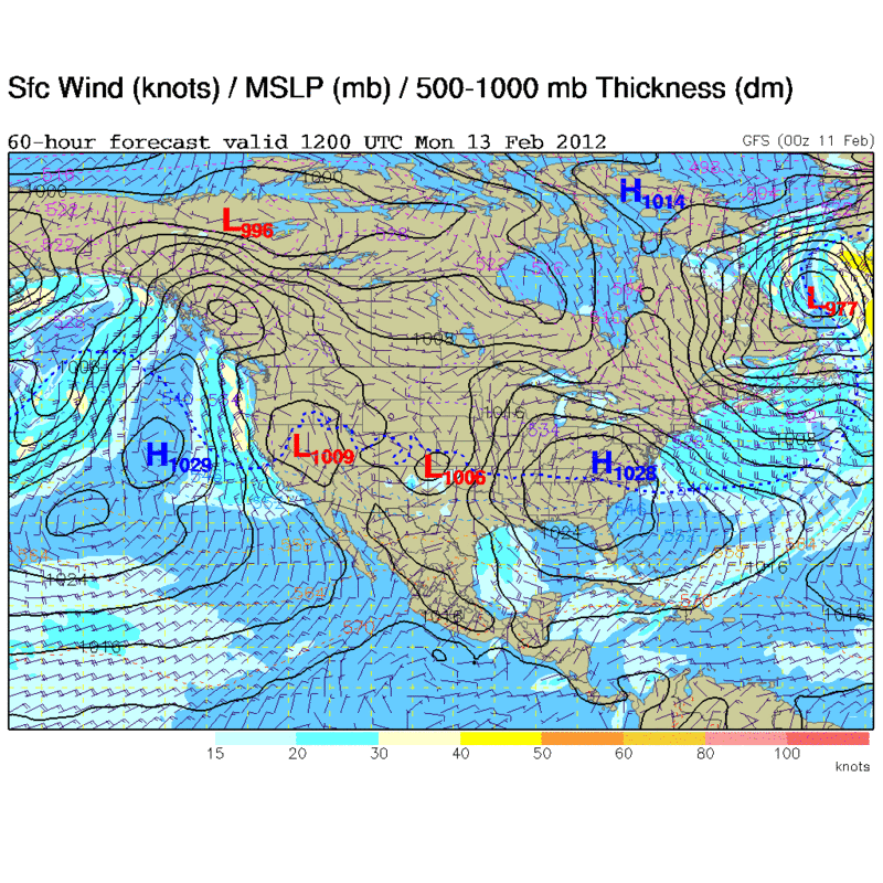
Posted: Sat Feb 11, 2012 10:43 am
by northjaxpro
Well, HPC surface analysis shows a 1044 mb Arctic High centered over Nebraska as of 14Z. This High has turned out to be a bit stronger than initially analyzed by the models 48 hours ago. This helps to explain the colder trends the past couple of days.
Winds picking up now as the pressure gradient with the building High Pressure from the Plains and the departing Low pressure area off the mid-Atlantic . A very good advective freeze event for tonight setting up across North Florida as hard freeze warnings are now in effect across this region.
NWS projected lows tomorrow morning:
Pensacola 25
Panama City 29
Tallahassee 24
Appalachicola 28
Jacksonville 27
Gainesville 26
Central Florida
Tampa 35
Orlando 36
Daytona Beach 34
For now, it appears that the freeze line will drop to near Brooksville -Leesburg - Flagler county observing the latest model runs. Hopefully, the freeze line won't drop a bit farther south to the I-4 corridor by tomorrow, but it is going to be a closer call down there than was initially expected 48 hours ago that's for sure.