Page 344 of 881
Re: Florida Weather
Posted: Tue Feb 28, 2012 8:45 am
by SFLcane
Patrick99 wrote:All the way at the end of the peninsula, it's been approaching, and occasionally reaching "downright hot." I really hope we get more "cool fronts" in March and April, but it's looking pretty grim, isn't it? Even if NAO dipped negative, I wonder if it'd be enough to get a little surge of cool air down here.
I don't like hard freezes that ruin Florida's crops, but I do like cool, comfortable weather...not really enjoying May weather in February, I don't know about you guys.
It's felt like spring most of the time the past few months with a few cool downs here and there. Really dont see any surges of real cold air moving into the state in the distant future either.
Re: Florida Weather
Posted: Tue Feb 28, 2012 4:25 pm
by Sanibel
Tied record highs at 89* and 86* last two days. May have broken today (87*). Should break tomorrow at 88* (previous record 86*)
Posted: Sat Mar 03, 2012 10:54 am
by northjaxpro
Tornadic cells already are occuring across the interior Big Ben area counties this morning. Tornado warning now up for Gadsden county, just west of Tallahassee.
A very impressive line of thunderstorms extending out from off the coast of Mississippi east-northeastward through the FL panhadle through Southern GA. Another busy day tracking these storms. I am afraid we will see numerous damage reports later today over portons of North Florida and into Southern Georgia. The remainder of North Florida will get affected later today into tonight as the front will slowly sags southeastward. Jax metro area will be affected by thunderstorms by tonight.
Posted: Sat Mar 03, 2012 5:01 pm
by northjaxpro
Tornado watch still in effect until 8 p.m. tonight for Jax metro area and much of North Florida. I am watching a new line of thunderstorms developing ahead of the large rain area in Southern GA in Northeast Florida from just north of Lake City northeast to Folkston, GA. This line is expanding in area and is being enregized further by the mid 80s temperatures out ahead of the frontal bounday. This is the line of storms that I am closely watching for the next couple of hours or so as it moves east-northeast rapidly.
Re: Florida Weather
Posted: Sun Mar 04, 2012 10:36 am
by Sanibel
Blustery moderate cold front 66*. Chilly tonight 45* then warming next few days.
Looks like this is our winter.
Posted: Sun Mar 04, 2012 10:52 am
by gsytch
Yesterday had a high of 88F with highest dewpoint at 70F BUT winds were gusting S/SW over 30mph. Right now....61F dewpoint 44F winds N/NW gusting over 30 mph with a high gust of 41mph with the squall at 4am. 3/10" of rain. So much has blown over in my shadehouses and yard I am just leaving it until the winds abate. Low of 45F tonight after a record high? No wonder there were tornadoes~

Re: Florida Weather
Posted: Sun Mar 04, 2012 4:58 pm
by Patrick99
Glad we are getting a cool shot. Friday and Saturday were as HOT as I've ever been in March. This winter has easily been one of the warmest I've ever experienced.
It'll only be upper 50s on the SE coast, but with the wind whipping around it should feel pretty chilly, and a far cry from what it has been.
Unfortunately, I know the blowtorch is set to return in a couple days. Still hope this won't be the last "cool front."
Posted: Wed Mar 07, 2012 5:12 pm
by gsytch
The winds in March, typically strong, have been stronger than usual. Sunday had gusts over 50mph after the front moved through here, and there was slight damage in Tampa Bay. MOnday morning had 44.5F in my yard. Today was again windy, gusts near 30mph like yesterday, but each day is warming nicely as evidenced by the 80's this afternoon and the 61F this morning. The humidity is quite low. I'll enjoy it while it lasts. The plants in the growhouses and yard are JUMPING!
Posted: Fri Mar 09, 2012 5:24 pm
by NDG
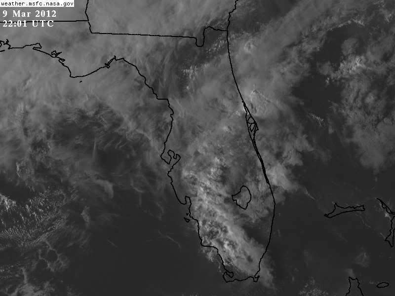
Amazing, yet another seabreeze collision of storms across interior Peninsula areas.
Is this early March or May?

Posted: Sat Mar 10, 2012 5:19 am
by JonathanBelles
My Florida forecast discussion:
http://wp.me/p1xnuB-5f
Re: Florida Weather
Posted: Sun Mar 11, 2012 11:00 am
by Sanibel
The tops weren't very high to that airmass convergence convection.
We had rain Friday and Sunday.
Posted: Mon Mar 12, 2012 8:49 pm
by gsytch
Nothing here. We've had a total of .20" of rain in March in one rain that lasted an hour. The forecast looks bleak as spring rolls in. 60;s lows 80;s highs all week, mostly sunny to prtly sunny and breezy. This is more like April than March AND the lack of rainfall............
Posted: Mon Mar 12, 2012 10:28 pm
by psyclone
This weather is just as good as it gets. april is one of our nicest months of the year. and this year it has come early. reliable, sunny and warm days in the 80's and nights in the 60's...i hope it lasts a couple more months before the summer swelter sets in...or at least a month and a half:)
Posted: Mon Mar 12, 2012 11:49 pm
by JonathanBelles
Allergies are in full force and then some in Tallahassee. One of my professors was out today due to the allergies, and my eyes are both red even with prescription drops and allergy meds.
Posted: Tue Mar 13, 2012 12:55 am
by JonathanBelles
Florida Forecast Update: A few showers possible across north Florida and Pollen is causing headaches for allergy sufferers:
http://jonathanbelles.wordpress.com/201 ... rch13flwx/
Posted: Thu Mar 15, 2012 7:07 pm
by NDG
The skies over the peninsula today looked more like late April-May type of wx with yet again more seabreeze-daytime heating isolated showers forming.
Posted: Thu Mar 15, 2012 7:21 pm
by HURAKAN
Got 1.08 inches of rain today .. woohoo!!!

Posted: Fri Mar 16, 2012 11:57 am
by JonathanBelles
HOT HOT HOT up here in the tri-state area! Bainbridge, GA hit 90 yesterday and Tally hit 88 degrees.
Re: Florida Weather
Posted: Fri Mar 16, 2012 2:56 pm
by Sanibel
The heliconia and Amaryllis are blooming 7 weeks early.
Abnormally warm here early.
Re: Florida Weather
Posted: Wed Mar 21, 2012 6:27 pm
by Tampa Bay Hurricane
Well Defined Line of Thunderstorms has formed along the seabreeze collision boundary over Tampa and along
the West Coast.
http://www.srh.noaa.gov/tbw
