Page 39 of 112
Re: Texas Fall 2018
Posted: Fri Oct 12, 2018 9:22 pm
by BrokenGlass
srainhoutx wrote:South Texas Storms wrote:Looking forward to the wet pattern across the state! El Nino is here

The Highland Lakes are full as well as the Aquifers. Life is good in Texas...

Remember when the Highland Lakes were never going to be full again?
Sent from my iPhone using Tapatalk Pro
Re: Texas Fall 2018
Posted: Fri Oct 12, 2018 9:25 pm
by Ntxw
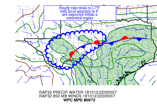
Mesoscale Precipitation Discussion 0972
NWS Weather Prediction Center College Park MD
748 PM EDT Fri Oct 12 2018
Areas affected...Western & Central TX
Concerning...Heavy rainfall...Flash flooding possible
Valid 122347Z - 130547Z
Summary...Thunderstorms are increasing in coverage across the area
ahead of Sergio's remnants. Hourly rain totals to 1.75" and local
amounts to 4" are possible prior to 06z.
Discussion...Satellite imagery reveals the remains of Sergio near
30N 108.5W, about 160 miles west-southwest of El Paso. The
environment ahead of the system is moistening, with precipitable
water values of 1.25-1.75". The activity is near and just north
of a thermal boundary lying across the region, which has ML CAPE
values of 500-1500 J/kg. While inflow at 850 hPa is 10-15 kts per
VAD wind profile data, effective bulk shear of 30-55 kts lies
here, which appears to have led to the development of a
mesocyclone well south-southwest of Midland TX. Showers and
thunderstorms have been festering in central TX and showing signs
of greater organization in and near western TX.
The expectation is for convection to fill in and increase in
intensity in time across two areas: near the Texas Big Bend/Pecos
River Valley and in the vicinity of the northern Concho Valley.
After 03z, convergent low-level inflow is expected to increase
which should import greater moisture into the region The 18z HREF
probabilities of exceeding 1" an hour peak in the 03-04z time
frame near the Concho Valley and are high after 03z as the remains
of Sergio move into the Trans Pecos region. The portion of the
boundary is western TX is expected to lift somewhat to the north
in the meantime. The HRRR/RAP guidance appear well behind the
curve concerning the recent uptick near the Concho Valley, so the
heavy rainfall could occur sooner than advertised. Hourly rain
totals to 1.75" with local amounts to 4" are anticipated. Soils
have been saturated by recent rainfall totaling over 300% of
normal. Flash flooding is a concern.
Roth
ATTN...WFO...EWX...FWD...MAF...SJT...
ATTN...RFC...WGRFC...
Re: Texas Fall 2018
Posted: Fri Oct 12, 2018 10:25 pm
by South Texas Storms
srainhoutx wrote:South Texas Storms wrote:Looking forward to the wet pattern across the state! El Nino is here
The Highland Lakes are full as well as the Aquifers. Life is good in Texas...
It definitely is, praise the Lord!
We have a lot to be thankful for in terms of rainfall over the past few years. We haven't seen much in the way of widespread significant drought in quite a while.
Re: Texas Fall 2018
Posted: Fri Oct 12, 2018 10:48 pm
by funster
Persistent thin band of rain slowly lifting up into Fort Worth and Dallas
https://www.wfaa.com/regional-hd-radar
Re: Texas Fall 2018
Posted: Fri Oct 12, 2018 11:18 pm
by TeamPlayersBlue
Hows the siberian snow advance looking?
Re: Texas Fall 2018
Posted: Fri Oct 12, 2018 11:26 pm
by Haris

just wow
Re: Texas Fall 2018
Posted: Sat Oct 13, 2018 12:07 am
by Cpv17
Look at that EPAC hurricane the GFS has. That could really play a role in our weather in about 10-15 days.
Re: Texas Fall 2018
Posted: Sat Oct 13, 2018 7:58 am
by Cpv17
Re: Texas Fall 2018
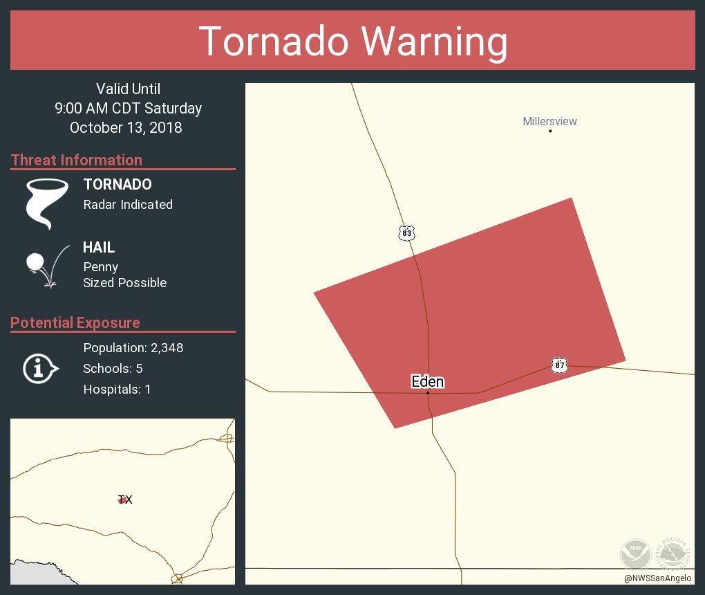
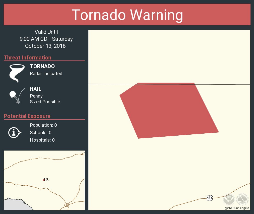
Posted: Sat Oct 13, 2018 8:51 am
by bubba hotep
A couple of tornado warnings out there this morning
Re: Texas Fall 2018
Posted: Sat Oct 13, 2018 8:54 am
by bubba hotep
Haris wrote:How do you upload radar gifs? Thx
Save the gif, then upload it to a free image hosting site like
https://imgbb.com/ and then copy the link and paste it in in the image code (use button labeled Img) . There are other ways to do it, so maybe so others will give some tips.
Re: Texas Fall 2018
Posted: Sat Oct 13, 2018 9:01 am
by Ntxw
You also have to make sure the source when you save it as a GIF does actually animate. Some frame based animations don't actually save the entire loop but just a particular frame.
College of DuPage nexrad products radar loops have a download option and is pretty good. If you have the RadarScope app it is also a good source for GIFs to upload
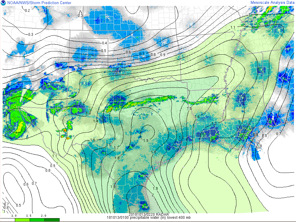
https://weather.cod.edu/satrad/Rain is coming #Sergio
Re: Texas Fall 2018
Posted: Sat Oct 13, 2018 9:12 am
by Ntxw
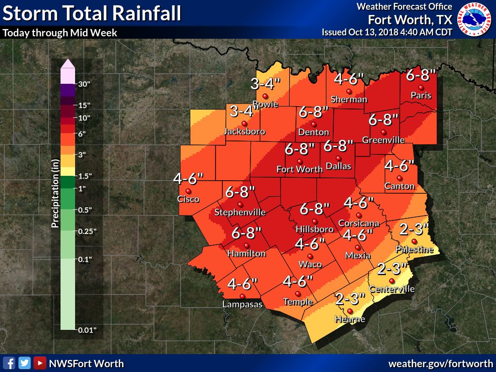
For DFW the October monthly record rainfall is 14.18" of rain. So far the airport is at 3.83". If an additional 6-8" falls as forecast the next several days, we'll have a shot at the record by the end of the month.
Re: Texas Fall 2018
Posted: Sat Oct 13, 2018 9:44 am
by funster
Following the wettest September with the wettest October would be impressive.
Re: Texas Fall 2018
Posted: Sat Oct 13, 2018 9:53 am
by Ntxw
funster wrote:Following the wettest September with the wettest October would be impressive.
I don't think DFW has ever had 3 Calendar months with double digit rainfalls. February..September....October? 2015 Came close with October/November coming close to joining May of that year.
If April, May, June, and July weren't so below normal, we'd be easily topping 2015
Note: After 2020 when the next climo data subset comes out (running 30 year averages) the big airport will have higher temperature normals, at the same time the annual rainfall average will rise. Shift closer to the East Texas climate vs West Texas. We've had some big totals since 1990. 4 of the top 10 wettest years have occurred since 1990, soon to be 5 or half.
Re: Texas Fall 2018
Posted: Sat Oct 13, 2018 10:33 am
by rwfromkansas
Just passed 1.60 already in north Fort Worth after .40 yesterday.
Re: Texas Fall 2018
Posted: Sat Oct 13, 2018 10:49 am
by bubba hotep
A couple more tornado warnings out there. Stormy day across Texas.

Re: Texas Fall 2018
Posted: Sat Oct 13, 2018 11:04 am
by bubba hotep
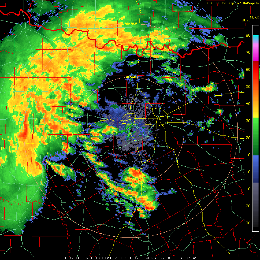
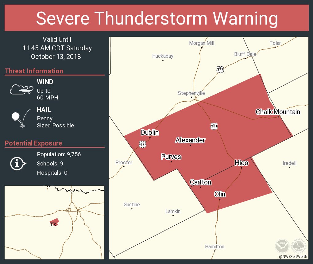
Svr Tstorm Warning
Re: Texas Fall 2018
Posted: Sat Oct 13, 2018 11:11 am
by Yukon Cornelius
3” so far out here. Everything is flooded. The chickens and cows better learn how to swim..
Re: Texas Fall 2018
Posted: Sat Oct 13, 2018 12:01 pm
by rwfromkansas
Wow, now up to 2.20! if it’s supposed to be even heavier after Sunday, yikes!
Re: Texas Fall 2018
Posted: Sat Oct 13, 2018 12:14 pm
by Ntxw
rwfromkansas wrote:Wow, now up to 2.20! if it’s supposed to be even heavier after Sunday, yikes!
This is the early extra from Sergio. The big 6-8" of rain comes with the big front Sunday through Tuesday.
