Texas Fall-2015

U.S. & Caribbean Weather Discussions and Severe Weather Events

Moderator: S2k Moderators

Forum rules

The posts in this forum are NOT official forecast and should not be used as such. They are just the opinion of the poster and may or may not be backed by sound meteorological data. They are NOT endorsed by any professional institution or STORM2K.

Help Support Storm2K
Message
Author
Ntxw
Storm2k Moderator
Storm2k Moderator
Posts: 21558
Joined: Wed Oct 21, 2009 6:34 pm
Location: DFW, Texas

Re: Texas Fall-2015

#81 Postby Ntxw » Fri Sep 04, 2015 8:03 pm

Brent wrote:The GFS out in fantasy land has basically no warmup(outside of maybe a day or two) before more wind shifts/fronts... northerly flow remains in place for a few days after the Friday front. It has mostly lows in the 60s(around 70 at the worst) behind it.

so I definitely think the fronts are going to be a regular thing

Weatherbug has dropped to 80/65 next Sunday up here NE of DFW. :double:


Hope so, the Euro weeklies from yesterday was showing that too. And deep storm in the southwest/southern Rockies with EPAC storms recurving. So not only it is a cooling trend, it is also a wet one. Flow from the Pacific subtropical jet.
0 likes   
The above post and any post by Ntxw is NOT an official forecast and should not be used as such. It is just the opinion of the poster and may or may not be backed by sound meteorological data. It is NOT endorsed by any professional institution including Storm2k. For official information, please refer to NWS products.

  Help support Storm2K!
Help Support Storm2K

weatherdude1108
Category 5
Category 5
Posts: 4172
Joined: Tue Dec 13, 2011 1:04 pm
Location: Northwest Austin/Cedar Park, TX

#82 Postby weatherdude1108 » Fri Sep 04, 2015 8:24 pm

:uarrow:
I think the Fall El Niño transition is happening! :D
Last edited by weatherdude1108 on Fri Sep 04, 2015 8:42 pm, edited 1 time in total.
0 likes   
The preceding post is NOT an official forecast, and should not be used as such. It is only the opinion of the poster and may or may not be backed by sound meteorological data. It is NOT endorsed by any professional institution including storm2k.org. For Official Information please refer to the NHC and NWS products.

Ntxw
Storm2k Moderator
Storm2k Moderator
Posts: 21558
Joined: Wed Oct 21, 2009 6:34 pm
Location: DFW, Texas

Re: Texas Fall-2015

#83 Postby Ntxw » Fri Sep 04, 2015 8:42 pm

Ryan Maue tweeted this satellite image I thought was pretty cool. Kevin's moisture streaming north. Unfortunately the current ridging pattern doesn't favor it coming to Texas. However in a couple of weeks with the breakdown of ridging and possibly big hurricanes there will look impressive. Bad for the west coast of Mexico though but good for us.

Image

Speaking of El Nino, lots of fresh data being the new month. Most guidance has this being the top 2 of El Nino events. Currently in the vicinity at the top with 1997. When coupled with the ocean and atmosphere, not many others can beat it. We won't see another El Nino of this magnitude again for perhaps another decade so take it all in.
0 likes   
The above post and any post by Ntxw is NOT an official forecast and should not be used as such. It is just the opinion of the poster and may or may not be backed by sound meteorological data. It is NOT endorsed by any professional institution including Storm2k. For official information, please refer to NWS products.


  Help support Storm2K!

Help Support Storm2K


Brent
S2K Supporter
S2K Supporter
Posts: 37139
Age: 35
Joined: Sun May 16, 2004 10:30 pm
Location: Tulsa Oklahoma
Contact:

Re: Texas Fall-2015

#84 Postby Brent » Fri Sep 04, 2015 9:12 pm

I don't really like looking at Accuweather's 45-day forecast... but I am looking at it through the 1st of October and if it verifies wow. Highs upper 70s/around 80 after the 23rd all the way through... and a few rainy days... and that's not even hanging at climo(which I've found with this forecast before) which is more mid 80s.

What's funny is it has mid 90s next weekend when the forecast is easily mid 80s if not lower. Lol. Only has 1 90 after that.
0 likes   
#neversummer

User avatar
TheProfessor
Professional-Met
Professional-Met
Posts: 3505
Age: 27
Joined: Tue Dec 03, 2013 10:56 am
Location: Wichita, Kansas

Re: Texas Fall-2015

#85 Postby TheProfessor » Fri Sep 04, 2015 11:14 pm

Ntxw wrote:Ryan Maue tweeted this satellite image I thought was pretty cool. Kevin's moisture streaming north. Unfortunately the current ridging pattern doesn't favor it coming to Texas. However in a couple of weeks with the breakdown of ridging and possibly big hurricanes there will look impressive. Bad for the west coast of Mexico though but good for us.

Image

Speaking of El Nino, lots of fresh data being the new month. Most guidance has this being the top 2 of El Nino events. Currently in the vicinity at the top with 1997. When coupled with the ocean and atmosphere, not many others can beat it. We won't see another El Nino of this magnitude again for perhaps another decade so take it all in.


The ridge should get pushed east a bit or at the very least weaken a bit as the Low pressure currently in the Northwest moves to the East-Northeast.
0 likes   
An alumnus of The Ohio State University.

Your local National Weather Service office is your best source for weather information.

Ntxw
Storm2k Moderator
Storm2k Moderator
Posts: 21558
Joined: Wed Oct 21, 2009 6:34 pm
Location: DFW, Texas

#86 Postby Ntxw » Sat Sep 05, 2015 10:39 am

One tid bit to note is that this summer the Arctic Oscillation and North Atlantic Oscillation have been hard pressed to go positive. This is opposite of the past 2 season which the AO/NAO couplet have raged positive. Will the persistence continue?

Image

Remember we don't need the AO/NAO (though it helps; EPO is important for Arctic outbreaks in Texas) for severe Arctic outbreaks but storms, and snow, and blocking systems as well as keeping it colder for longer they do play a role. 2009-2010 if you remember was not memorable so much for the big arctic attacks, but rather sustained cold and numerous bowling ball storms. Especially December, and Feb, of that year with the severely -AO/NAO
0 likes   
The above post and any post by Ntxw is NOT an official forecast and should not be used as such. It is just the opinion of the poster and may or may not be backed by sound meteorological data. It is NOT endorsed by any professional institution including Storm2k. For official information, please refer to NWS products.


  Help support Storm2K!

Help Support Storm2K


weatherdude1108
Category 5
Category 5
Posts: 4172
Joined: Tue Dec 13, 2011 1:04 pm
Location: Northwest Austin/Cedar Park, TX

#87 Postby weatherdude1108 » Sat Sep 05, 2015 12:03 pm

Just got a HEAVY shower at the house. :rain: :D
0 likes   

User avatar
ravyrn
S2K Supporter
S2K Supporter
Posts: 992
Age: 41
Joined: Sun Aug 31, 2008 5:10 am
Location: Alderbranch, TX

Re: Texas Fall-2015

#88 Postby ravyrn » Sat Sep 05, 2015 1:05 pm

My forecast:

DFW - 9/26

AUS - 10/13

IAH - 9/27
0 likes   

gpsnowman
S2K Supporter
S2K Supporter
Posts: 2729
Joined: Fri Jan 07, 2011 10:35 am
Location: Grand Prairie Tx

#89 Postby gpsnowman » Sat Sep 05, 2015 7:32 pm

Just a few more days. Just a few more days. Just a few more days. :D
0 likes   

Brent
S2K Supporter
S2K Supporter
Posts: 37139
Age: 35
Joined: Sun May 16, 2004 10:30 pm
Location: Tulsa Oklahoma
Contact:

Re:

#90 Postby Brent » Sat Sep 05, 2015 9:01 pm

gpsnowman wrote:Just a few more days. Just a few more days. Just a few more days. :D


I can't like this enough. :lol:
0 likes   
#neversummer

User avatar
South Texas Storms
Professional-Met
Professional-Met
Posts: 4028
Joined: Thu Jun 24, 2010 12:28 am
Location: Houston, TX

Re: Texas Fall-2015

#91 Postby South Texas Storms » Sun Sep 06, 2015 5:16 pm

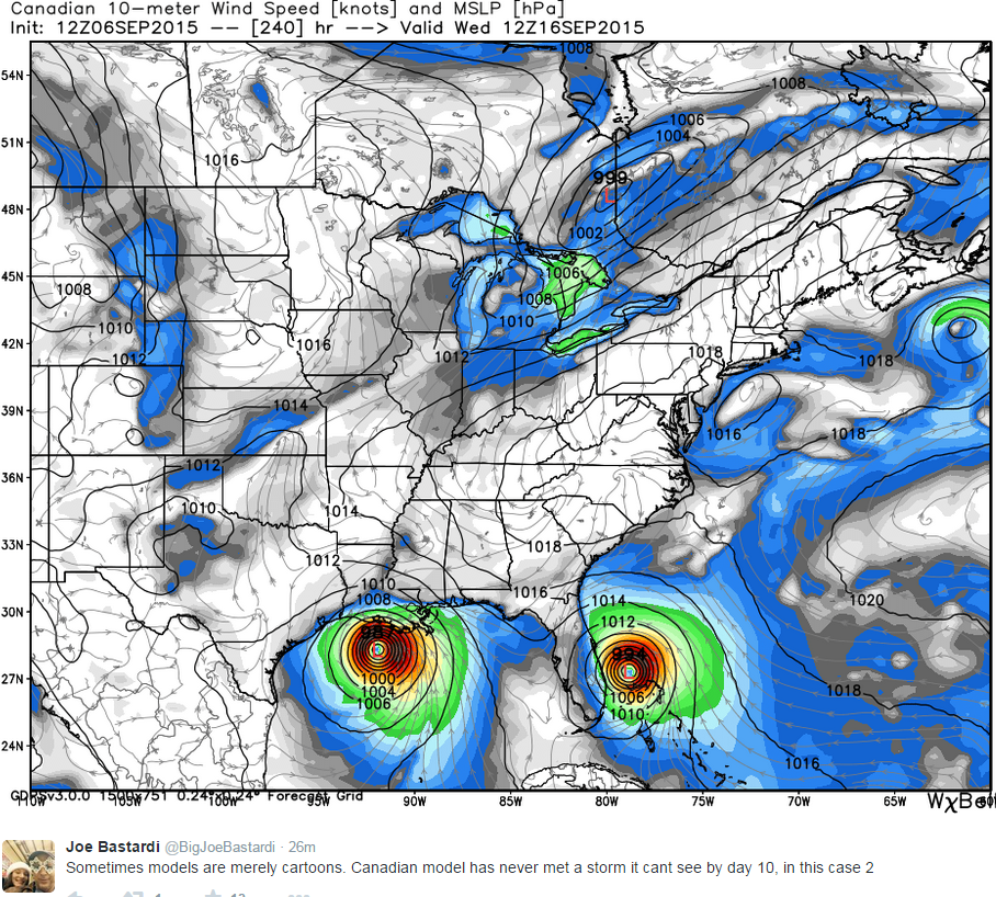
Today's 12z Euro run is very interesting in the long range period (8-10 days from now). First, in about 6 days it shows a tropical storm forming from a stalled cold frontal boundary in the NW Gulf and then it moves onshore near Beaumont in 8 days. Second, it shows a strong cold front moving through the Plains associated with a deep upper-level trough when the run ends in 10 days. If the Euro verifies, blizzard conditions would likely occur in the Northern Rockies in 10 days.
0 likes   

Brent
S2K Supporter
S2K Supporter
Posts: 37139
Age: 35
Joined: Sun May 16, 2004 10:30 pm
Location: Tulsa Oklahoma
Contact:

Re: Texas Fall-2015

#92 Postby Brent » Sun Sep 06, 2015 7:01 pm

South Texas Storms wrote:Today's 12z Euro run is very interesting in the long range period (8-10 days from now). First, in about 6 days it shows a tropical storm forming from a stalled cold frontal boundary in the NW Gulf and then it moves onshore near Beaumont in 8 days. Second, it shows a strong cold front moving through the Plains associated with a deep upper-level trough when the run ends in 10 days. If the Euro verifies, blizzard conditions would likely occur in the Northern Rockies in 10 days.


Awesome...

14th 100 degree day at DFW this year today

The GFS annoys me. Now it trends warmer and has no lows below 70 for awhile. :roll:
0 likes   
#neversummer

User avatar
Rgv20
S2K Supporter
S2K Supporter
Posts: 2456
Age: 37
Joined: Wed Jan 05, 2011 5:42 pm
Location: Edinburg/McAllen Tx

Re: Texas Fall-2015

#93 Postby Rgv20 » Sun Sep 06, 2015 8:10 pm

South Texas Storms wrote:Today's 12z Euro run is very interesting in the long range period (8-10 days from now). First, in about 6 days it shows a tropical storm forming from a stalled cold frontal boundary in the NW Gulf and then it moves onshore near Beaumont in 8 days.


18zGFS hints at a low forming just south of Brownsville and quickly moves it north by late in the weekend...a couple of the 12zECMWF Ensemble agree with the scenario suggested by the Operational ECMWF and 18zGFS. Will shall see if future models run continue to indicate this possible low.
0 likes   
The following post is NOT an official forecast and should not be used as such. It is just the opinion of the poster and may or may not be backed by sound meteorological data. It is NOT endorsed by any professional institution including storm2k.org For Official Information please refer to the NHC and NWS products.

Ntxw
Storm2k Moderator
Storm2k Moderator
Posts: 21558
Joined: Wed Oct 21, 2009 6:34 pm
Location: DFW, Texas

#94 Postby Ntxw » Sun Sep 06, 2015 9:01 pm

I would also keep an eye on Tropical Storm Linda in the EPAC. This one could be rapidly intensifying and become a seriously powerful hurricane. While it is not forecasted to make landfall, with a trough digging in it's moisture will stream up northeastward interacting with frontal boundaries across the state.

Also reminder tomorrow is the last day to post 59F or lower predictions for the three sites. Jump in, who knows you might win it just guessing!
0 likes   
The above post and any post by Ntxw is NOT an official forecast and should not be used as such. It is just the opinion of the poster and may or may not be backed by sound meteorological data. It is NOT endorsed by any professional institution including Storm2k. For official information, please refer to NWS products.


  Help support Storm2K!

Help Support Storm2K


aggiecutter
Category 5
Category 5
Posts: 1743
Joined: Thu Oct 14, 2004 9:22 pm
Location: Texarkana

Re: Texas Fall-2015

#95 Postby aggiecutter » Sun Sep 06, 2015 10:35 pm

South Texas Storms wrote:Today's 12z Euro run is very interesting in the long range period (8-10 days from now). First, in about 6 days it shows a tropical storm forming from a stalled cold frontal boundary in the NW Gulf and then it moves onshore near Beaumont in 8 days. Second, it shows a strong cold front moving through the Plains associated with a deep upper-level trough when the run ends in 10 days. If the Euro verifies, blizzard conditions would likely occur in the Northern Rockies in 10 days.


Image
0 likes   

weatherdude1108
Category 5
Category 5
Posts: 4172
Joined: Tue Dec 13, 2011 1:04 pm
Location: Northwest Austin/Cedar Park, TX

#96 Postby weatherdude1108 » Sun Sep 06, 2015 10:51 pm

Something to talk about for a change. :wink:

Image
0 likes   
The preceding post is NOT an official forecast, and should not be used as such. It is only the opinion of the poster and may or may not be backed by sound meteorological data. It is NOT endorsed by any professional institution including storm2k.org. For Official Information please refer to the NHC and NWS products.

Ntxw
Storm2k Moderator
Storm2k Moderator
Posts: 21558
Joined: Wed Oct 21, 2009 6:34 pm
Location: DFW, Texas

#97 Postby Ntxw » Sun Sep 06, 2015 11:04 pm

I'm not sold on a gulf named entity (yet). Conditions are not too conducive and there will be shear a plenty with passing cold front(s). I think the models are doing their usual spin stuff up as height falls with the fronts. Though I can believe a chug of moisture could very well come up from the BOC. It won't have too much time to develop though, as I mentioned look towards the EPAC from STJ enhancement.
0 likes   
The above post and any post by Ntxw is NOT an official forecast and should not be used as such. It is just the opinion of the poster and may or may not be backed by sound meteorological data. It is NOT endorsed by any professional institution including Storm2k. For official information, please refer to NWS products.


  Help support Storm2K!

Help Support Storm2K


Brent
S2K Supporter
S2K Supporter
Posts: 37139
Age: 35
Joined: Sun May 16, 2004 10:30 pm
Location: Tulsa Oklahoma
Contact:

Re: Texas Fall-2015

#98 Postby Brent » Mon Sep 07, 2015 2:14 am

Well this is interesting...

Image

and ugh... what happened to the big cool down next weekend? We've gone from highs close to 80 to highs around 90. *shrugs* Bordering on just a less hot front again instead of fall. :roll:
0 likes   
#neversummer

User avatar
Rgv20
S2K Supporter
S2K Supporter
Posts: 2456
Age: 37
Joined: Wed Jan 05, 2011 5:42 pm
Location: Edinburg/McAllen Tx

#99 Postby Rgv20 » Mon Sep 07, 2015 8:54 am

6zGFS still hints at a possible Low developing south of Brownsville but not as extreme as the 0zECMWF.....0zECMWF Ensembles are not as deep with the low pressure system as the operational run. Hopefully South Texas gets a good drink out of it!
0 likes   
The following post is NOT an official forecast and should not be used as such. It is just the opinion of the poster and may or may not be backed by sound meteorological data. It is NOT endorsed by any professional institution including storm2k.org For Official Information please refer to the NHC and NWS products.

User avatar
Rgv20
S2K Supporter
S2K Supporter
Posts: 2456
Age: 37
Joined: Wed Jan 05, 2011 5:42 pm
Location: Edinburg/McAllen Tx

#100 Postby Rgv20 » Mon Sep 07, 2015 10:09 am

NWS in Houston on the possibility of an organize Low Pressure System..

SUNDAY THINGS BEGIN TO GET CONCERNING... MODELS
HAVE BEEN HAVING SOME ISSUES WITH DEVELOPMENT OF TROUGHING ALOFT
OVER TX/MEXICO THE LAST FEW RUNS...DOING SO THEN BACKING OFF. NOW
BOTH THE 00Z GFS/ECMWF HAVE BEGUN TO COALESCE TOWARDS A VERY WET
SOLUTION STARTING LATE NEXT SUNDAY FOR THE GFS EXPANDING NORTHWARD
INTO SETX EARLY MONDAY THROUGH TUESDAY...WHILE THE ECMWF IS 6
HOURS OR SO SLOWER BUT MORE INTENSE...PW SURGING TO 2.5-2.6"!
BOTH MODELS DEVELOP A VERY ORGANIZED LOW PRESSURE SYSTEM (PERHAPS
INITIALLY A COASTAL TROUGH ON THE TAIL END OF THE REMNANT FRONT)
THAT QUICKLY WRAPS UP AND MOVES INTO SETX. THIS SCENARIO MAY HAVE
THE POTENTIAL FOR TROPICAL DEVELOPMENT. STAY TUNED.
0 likes   
The following post is NOT an official forecast and should not be used as such. It is just the opinion of the poster and may or may not be backed by sound meteorological data. It is NOT endorsed by any professional institution including storm2k.org For Official Information please refer to the NHC and NWS products.


Return to “USA & Caribbean Weather”

Who is online

Users browsing this forum: bubba hotep, HurricaneBelle and 15 guests