Page 5 of 6
Re: Severe weather Jan 20-23,2017
Posted: Sun Jan 22, 2017 12:31 pm
by AdamFirst
Bunkertor wrote:If you come along radio coverage ( or TV ) , would you mind copy and pasting it ? Backup links aka ustream also welcome.
http://www.actionnewsjax.com/live-stream-loopCBS 47/FOX 30 (Jacksonville) is currently streaming, they'll break in and out as conditions warrant
Re: Severe weather Jan 20-23,2017
Posted: Sun Jan 22, 2017 12:36 pm
by northjaxpro
Visible satellite imahery and composite radar imagery is showing the development of a squall line jfrom extreme SE AL southward to down into the Gulf of Mexico. Needless to say, this squall line will have to be watched extremely closely as this squall line moves northeast throughout the afternoon.
Re: Severe weather Jan 20-23,2017
Posted: Sun Jan 22, 2017 12:45 pm
by AdamFirst
Re: Severe weather Jan 20-23,2017
Posted: Sun Jan 22, 2017 12:47 pm
by Bunkertor
Yes, i have checked them already some hours ago. Some can be found in the media category
Re: Severe weather Jan 20-23,2017
Posted: Sun Jan 22, 2017 12:48 pm
by EF-5bigj
Re: Severe weather Jan 20-23,2017
Posted: Sun Jan 22, 2017 12:48 pm
by TheAustinMan
Tornado watch #21 issued for parts of the Southeastern United States.

90% probabilities of EF2+ tornadoes, hail greater than 2", and wind greater than 65 knots listed in association with this particularly dangerous situation. Stay safe.
Re: Severe weather Jan 20-23,2017
Posted: Sun Jan 22, 2017 12:58 pm
by yzerfan
URGENT - IMMEDIATE BROADCAST REQUESTED
Tornado Watch Number 21
NWS Storm Prediction Center Norman OK
1245 PM EST Sun Jan 22 2017
The NWS Storm Prediction Center has issued a
* Tornado Watch for portions of
Southeast Alabama
North Florida
Central and Southern Georgia
Coastal Waters
* Effective this Sunday afternoon and evening from 1245 PM until
800 PM EST.
...THIS IS A PARTICULARLY DANGEROUS SITUATION...
* Primary threats include...
Several tornadoes and a few intense tornadoes likely
Widespread damaging winds and scattered significant gusts to 80
mph likely
Widespread large hail and scattered very large hail events to 2
inches in diameter likely
SUMMARY...An outbreak of severe storms and tornadoes is expected to
unfold over the watch area this afternoon. Storms currently over AL
and the FL panhandle will track rapidly northeastward, posing a risk
of long-track significant tornadoes and widespread damaging winds.
The tornado watch area is approximately along and 140 statute miles
north and south of a line from 20 miles southwest of Troy AL to 30
miles south southeast of Vidalia GA. For a complete depiction of the
watch see the associated watch outline update (WOUS64 KWNS WOU1).
Re: Severe weather Jan 20-23,2017
Posted: Sun Jan 22, 2017 1:00 pm
by psyclone
Pure octane pumping north from my area:
St Pete Clearwater (KPIE) 82/71 wind south at 31 gusting to 47mph.
Re: Severe weather Jan 20-23,2017
Posted: Sun Jan 22, 2017 1:13 pm
by WeatherGuesser
Last January High Risk I see was January 21, 1999 in AR
Re: Severe weather Jan 20-23,2017
Posted: Sun Jan 22, 2017 1:36 pm
by Evil Jeremy
Cells have started popping up inland North Florida. Severe Thunderstorm Warning in South Jacksonville. Looks like plenty of festivities ahead of the main band tonight.
Re: Severe weather Jan 20-23,2017
Posted: Sun Jan 22, 2017 1:48 pm
by northjaxpro
I just got off the phone with a close buddy of mine who just told me was in the middle of an absolute downpour with very strong winds down around The Avenues Mall area. He stated winds had to be around 50 mph range at least. I told him to report it i to the NWS Jax office.
Radar indeed is showing rain and thunderstorms popping up rapidly. I am not shocked as the atmosphere is so juiced right now. These cells will bring down strong winds to the surface given the dynamical set-up and shear in the atmosphere.
Re: Severe weather Jan 20-23,2017
Posted: Sun Jan 22, 2017 2:09 pm
by northjaxpro
Getting the first significant cell right now. Very heavy rain and wind gusted to 43 mph at my home station.
Re: Severe weather Jan 20-23,2017
Posted: Sun Jan 22, 2017 2:17 pm
by Tireman4
A PDS...in January...goodness gracious.
Re: Severe weather Jan 20-23,2017
Posted: Sun Jan 22, 2017 2:18 pm
by EF-5bigj
It's starting to get active now

Re: Severe weather Jan 20-23,2017
Posted: Sun Jan 22, 2017 2:52 pm
by Hypercane_Kyle
12z 3km NAM shows a pretty solid line moving through CFL at 01z.

Re: Severe weather Jan 20-23,2017
Posted: Sun Jan 22, 2017 3:00 pm
by WeatherGuesser
Also the first High Risk since June 3, 2014
I hope that's not an omen for this year.
Had to go back to 1993 to find a year with one and only one. Every other year that had one, had two or more.
Re: Severe weather Jan 20-23,2017
Posted: Sun Jan 22, 2017 3:22 pm
by Hypercane_Kyle
High risk extended to include Tampa.
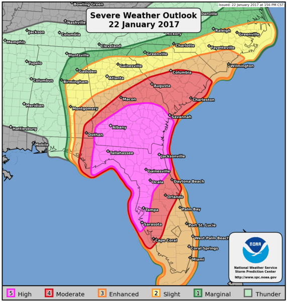
First time in my life I've ever been in a "high risk" SPC outlook.
Re: Severe weather Jan 20-23,2017
Posted: Sun Jan 22, 2017 3:39 pm
by EF-5bigj
A violent tornado ongoing in GA.
Re: Severe weather Jan 20-23,2017
Posted: Sun Jan 22, 2017 3:46 pm
by Bunkertor
EF-5bigj wrote:A violent tornado likely just his Albony,GA

197
WFUS52 KFFC 222042
TORFFC
GAC081-315-222130-
/O.NEW.KFFC.TO.W.0017.170122T2042Z-170122T2130Z/
BULLETIN - EAS ACTIVATION REQUESTED
TORNADO WARNING
NATIONAL WEATHER SERVICE PEACHTREE CITY GA
342 PM EST SUN JAN 22 2017
THE NATIONAL WEATHER SERVICE IN PEACHTREE CITY HAS ISSUED A
* TORNADO WARNING FOR...
WILCOX COUNTY IN CENTRAL GEORGIA...
EASTERN CRISP COUNTY IN CENTRAL GEORGIA...
* UNTIL 430 PM EST
* AT 341 PM EST, A CONFIRMED LARGE AND EXTREMELY DANGEROUS TORNADO
WAS LOCATED NEAR DOLES, OR 10 MILES NORTHWEST OF SYLVESTER, MOVING
NORTHEAST AT 65 MPH.
THIS IS A PARTICULARLY DANGEROUS SITUATION. TAKE COVER NOW!
HAZARD...DAMAGING TORNADO.
SOURCE...RADAR CONFIRMED TORNADO.
IMPACT...YOU ARE IN A LIFE-THREATENING SITUATION. FLYING DEBRIS
MAY BE DEADLY TO THOSE CAUGHT WITHOUT SHELTER. MOBILE
HOMES WILL BE DESTROYED. CONSIDERABLE DAMAGE TO HOMES,
BUSINESSES, AND VEHICLES IS LIKELY AND COMPLETE
DESTRUCTION IS POSSIBLE.
* LOCATIONS IMPACTED INCLUDE...
CORDELE, ABBEVILLE, ROCHELLE, ARABI, PINEVIEW, PITTS, EAST CRISP,
CEDAR CREEK, ANTIOCH CHURCH, POPE CITY, SEVILLE, HATLEY, BROWNING,
PLEASANT VIEW, DOUBLE RUN, WENONA AND OWENSBORO.
PRECAUTIONARY/PREPAREDNESS ACTIONS...
TO REPEAT, A LARGE, EXTREMELY DANGEROUS AND POTENTIALLY DEADLY
TORNADO IS ON THE GROUND. TO PROTECT YOUR LIFE, TAKE COVER NOW! MOVE
TO A BASEMENT OR AN INTERIOR ROOM ON THE LOWEST FLOOR OF A STURDY
BUILDING. AVOID WINDOWS. IF YOU ARE OUTDOORS, IN A MOBILE HOME, OR IN
A VEHICLE, MOVE TO THE CLOSEST SUBSTANTIAL SHELTER AND PROTECT
YOURSELF FROM FLYING DEBRIS.
IF YOU SEE WIND DAMAGE...HAIL OR FLOODING...WAIT UNTIL THE STORM HAS
PASSED...AND THEN CALL THE NATIONAL WEATHER SERVICE TOLL FREE
AT 1 8 6 6 7 6 3 4 4 6 6 OR TWEET US YOUR REPORT AT NWSATLANTA.
Re: Severe weather Jan 20-23,2017
Posted: Sun Jan 22, 2017 4:12 pm
by northjaxpro
Hypercane_Kyle wrote:High risk extended to include Tampa.
First time in my life I've ever been in a "high risk" SPC outlook.
I will say this, if ever there was a day to have a "extremely high risk" level by SPC, today. would be the day to have it in this region I can 100% assure you this fact.