Texas Summer 2017

U.S. & Caribbean Weather Discussions and Severe Weather Events

Moderator: S2k Moderators

Forum rules

The posts in this forum are NOT official forecast and should not be used as such. They are just the opinion of the poster and may or may not be backed by sound meteorological data. They are NOT endorsed by any professional institution or STORM2K.

Help Support Storm2K
Message
Author
User avatar
JDawg512
Category 5
Category 5
Posts: 1032
Age: 44
Joined: Mon Aug 26, 2013 8:56 pm
Location: Austin
Contact:

Re: Texas Summer 2017

#81 Postby JDawg512 » Sat Jun 03, 2017 10:26 pm

Texas Snowman wrote:
Ntxw wrote:
Texas Snowman wrote:I'm just hoping that the downpours will hold off this evening for a couple of hours so we can get my youngest son's Denison High School graduation in.

We dodged rain and storms two weeks ago when my father passed away, my daughter graduated from UT and we buried dad. It was always on the radar, just never exactly where we were at the moment.

I'm hoping for the same tonight, then it can rain buckets.


I am very sorry for your loss at the same time very happy for your kids on their achievements. Hopefully any rain will hold off to your south in the evening, there should be a lull after this current complex passes through.


Thank you Ntxw, I appreciate your kind words and hope that the rain does indeed hold off this evening in northern Grayson County.

Sherman High looks like they'll be getting in their late morning graduation. Hopefully, Denison High will get their ceremony in this evening.

You know, as is the case with a number of people on this forum, we've never met. But sometimes I feel like many of you great folks are a part of my extended family.


I agree. Everyone on here has become familiar through digital means. My condolences to you and your family Texas Snowman.


Two rounds of rain this evening and still falling. I'm watching flickers of lighting out my window, listening to the rain fall. I hope the rest of June continues like this.
1 likes   
Resident Rain Miser

I am a weather hobbyist living 3.5 miles south of Downtown Austin and in no way or fashion should anything I say concerning forecasts be taken seriously. Please check your local NWS for accurate weather forecasting and conditions.

Brent
S2K Supporter
S2K Supporter
Posts: 37137
Age: 35
Joined: Sun May 16, 2004 10:30 pm
Location: Tulsa Oklahoma
Contact:

Re: Texas Summer 2017

#82 Postby Brent » Sat Jun 03, 2017 10:27 pm

5 1/2 inches here since Thursday

What a start to summer. :lol:
0 likes   
#neversummer

weatherdude1108
Category 5
Category 5
Posts: 4172
Joined: Tue Dec 13, 2011 1:04 pm
Location: Northwest Austin/Cedar Park, TX

Re: Texas Summer 2017

#83 Postby weatherdude1108 » Sat Jun 03, 2017 10:32 pm

JDawg512 wrote:
Texas Snowman wrote:
Ntxw wrote:
I am very sorry for your loss at the same time very happy for your kids on their achievements. Hopefully any rain will hold off to your south in the evening, there should be a lull after this current complex passes through.


Thank you Ntxw, I appreciate your kind words and hope that the rain does indeed hold off this evening in northern Grayson County.

Sherman High looks like they'll be getting in their late morning graduation. Hopefully, Denison High will get their ceremony in this evening.

You know, as is the case with a number of people on this forum, we've never met. But sometimes I feel like many of you great folks are a part of my extended family.


I agree. Everyone on here has become familiar through digital means. My condolences to you and your family Texas Snowman.


Two rounds of rain this evening and still falling. I'm watching flickers of lighting out my window, listening to the rain fall. I hope the rest of June continues like this.


I am so sorry Texas Snowman. This place really does feel like a family.

As far as weather, I got 0.15 earlier today in a shower Was pouring a while ago. 1.5 inches total today. Still raining. Love it!
0 likes   
The preceding post is NOT an official forecast, and should not be used as such. It is only the opinion of the poster and may or may not be backed by sound meteorological data. It is NOT endorsed by any professional institution including storm2k.org. For Official Information please refer to the NHC and NWS products.

User avatar
bubba hotep
S2K Supporter
S2K Supporter
Posts: 5598
Joined: Wed Dec 28, 2016 1:00 am
Location: Collin County Texas

Re: Texas Summer 2017

#84 Postby bubba hotep » Sun Jun 04, 2017 7:47 am

Texas Snowman wrote:
Ntxw wrote:WFO discussion from FW this morning was pretty good

[div].DISCUSSION... /Issued 520 AM CDT Sat Jun 3 2017/
With the potential for
additional rounds of significant rainfall today and tonight, a
flash flood watch will be in effect from 7 am today to 7 am Sunday
along and northwest of a line from Comanche to Kaufman to Bonham.
This includes all of the Dallas/Fort Worth Metroplex as well as
the Sherman/Denison area.

Further convective initiation is likely through the
afternoon hours, particularly across the northwestern half of the
CWA which will be both within the favorable quadrant of the mid-
level low and beneath significant diffluence aloft.


I'm just hoping that the downpours will hold off this evening for a couple of hours so we can get my youngest son's Denison High School graduation in.

We dodged rain and storms two weeks ago when my father passed away, my daughter graduated from UT and we buried dad. It was always on the radar, just never exactly where we were at the moment.

I'm hoping for the same tonight, then it can rain buckets.


My condolences on the passing of your father. Also, good luck to your daughter and son as they start the next phases of life.
0 likes   
Winter time post are almost exclusively focused on the DFW area.

User avatar
bubba hotep
S2K Supporter
S2K Supporter
Posts: 5598
Joined: Wed Dec 28, 2016 1:00 am
Location: Collin County Texas

Re: Texas Summer 2017

#85 Postby bubba hotep » Sun Jun 04, 2017 1:02 pm

Maybe an enhanced chance of storms across DFW later?

 https://twitter.com/whatisthisrds/status/871426212433862656


0 likes   
Winter time post are almost exclusively focused on the DFW area.

User avatar
bubba hotep
S2K Supporter
S2K Supporter
Posts: 5598
Joined: Wed Dec 28, 2016 1:00 am
Location: Collin County Texas

Re: Texas Summer 2017

#86 Postby bubba hotep » Sun Jun 04, 2017 1:41 pm

Some areas out NW of DFW b/w 287 and 20 are adding to these totals this afternoon from slow moving storms:

Image
0 likes   
Winter time post are almost exclusively focused on the DFW area.

Ntxw
Storm2k Moderator
Storm2k Moderator
Posts: 21551
Joined: Wed Oct 21, 2009 6:34 pm
Location: DFW, Texas

Re: Texas Summer 2017

#87 Postby Ntxw » Sun Jun 04, 2017 3:46 pm

DFW airport for the month of June (through 3 days not including today) is at a healthy 2.93". The month as a whole averages 3.79" so really another good shower will get us there so lets keep those tallies up! If June turns out wet (as it was in 2004 and 2007 with hefty rain totals) our summer will likely be much more subdued heat wise. I know the post is a little DFW centric but the weakness is effecting all of Texas so it's a symptom of a much larger pattern.
1 likes   
The above post and any post by Ntxw is NOT an official forecast and should not be used as such. It is just the opinion of the poster and may or may not be backed by sound meteorological data. It is NOT endorsed by any professional institution including Storm2k. For official information, please refer to NWS products.

  Help support Storm2K!
Help Support Storm2K

User avatar
South Texas Storms
Professional-Met
Professional-Met
Posts: 4027
Joined: Thu Jun 24, 2010 12:28 am
Location: Houston, TX

Re: Texas Summer 2017

#88 Postby South Texas Storms » Sun Jun 04, 2017 4:25 pm

Ntxw wrote:DFW airport for the month of June (through 3 days not including today) is at a healthy 2.93". The month as a whole averages 3.79" so really another good shower will get us there so lets keep those tallies up! If June turns out wet (as it was in 2004 and 2007 with hefty rain totals) our summer will likely be much more subdued heat wise. I know the post is a little DFW centric but the weakness is effecting all of Texas so it's a symptom of a much larger pattern.


Unfortunately south central Texas has been largely missing out during this unsettled weather pattern. San Antonio and Austin are still below normal over the past month. Hopefully that will change soon.
0 likes   

User avatar
bubba hotep
S2K Supporter
S2K Supporter
Posts: 5598
Joined: Wed Dec 28, 2016 1:00 am
Location: Collin County Texas

Re: Texas Summer 2017

#89 Postby bubba hotep » Sun Jun 04, 2017 4:30 pm

Ntxw wrote:DFW airport for the month of June (through 3 days not including today) is at a healthy 2.93". The month as a whole averages 3.79" so really another good shower will get us there so lets keep those tallies up! If June turns out wet (as it was in 2004 and 2007 with hefty rain totals) our summer will likely be much more subdued heat wise. I know the post is a little DFW centric but the weakness is effecting all of Texas so it's a symptom of a much larger pattern.


Maybe this cell moving out of Ft. Worth can clip the airport?

Image
0 likes   
Winter time post are almost exclusively focused on the DFW area.

Brent
S2K Supporter
S2K Supporter
Posts: 37137
Age: 35
Joined: Sun May 16, 2004 10:30 pm
Location: Tulsa Oklahoma
Contact:

Re: Texas Summer 2017

#90 Postby Brent » Sun Jun 04, 2017 8:18 pm

We looked to miss out on this latest round up in Wylie and now it's blown up over us lol
0 likes   
#neversummer

User avatar
bubba hotep
S2K Supporter
S2K Supporter
Posts: 5598
Joined: Wed Dec 28, 2016 1:00 am
Location: Collin County Texas

Re: Texas Summer 2017

#91 Postby bubba hotep » Sun Jun 04, 2017 9:51 pm

Brent wrote:We looked to miss out on this latest round up in Wylie and now it's blown up over us lol


I was pretty bummed as storms moved past to the N and S but then a couple of funky outflow boundary interactions and a storm pushed back to the W and got us

Image

Image
0 likes   
Winter time post are almost exclusively focused on the DFW area.

User avatar
bubba hotep
S2K Supporter
S2K Supporter
Posts: 5598
Joined: Wed Dec 28, 2016 1:00 am
Location: Collin County Texas

Re: Texas Summer 2017

#92 Postby bubba hotep » Sun Jun 04, 2017 10:02 pm

The Euro has been playing around with a big western trough in the longer range. The 12z from today has a pretty deep trough and it has PW anomalies 2+ std across most all of Texas. There is deep tropical moisture streaming up from the Gulf and flooding into Texas. Depending on ejection, this could be another shot at a big rain event.

Image
0 likes   
Winter time post are almost exclusively focused on the DFW area.

User avatar
bubba hotep
S2K Supporter
S2K Supporter
Posts: 5598
Joined: Wed Dec 28, 2016 1:00 am
Location: Collin County Texas

Re: Texas Summer 2017

#93 Postby bubba hotep » Sun Jun 04, 2017 10:28 pm

Awesome pic from the afternoon storms

 https://twitter.com/jack_jack62192/status/871500088232648705


1 likes   
Winter time post are almost exclusively focused on the DFW area.

weatherdude1108
Category 5
Category 5
Posts: 4172
Joined: Tue Dec 13, 2011 1:04 pm
Location: Northwest Austin/Cedar Park, TX

Re: Texas Summer 2017

#94 Postby weatherdude1108 » Mon Jun 05, 2017 8:03 am

:uarrow:
That looks like a textbook microburst, the way the heavy rain flares out at the base. Cool pic! :)
0 likes   
The preceding post is NOT an official forecast, and should not be used as such. It is only the opinion of the poster and may or may not be backed by sound meteorological data. It is NOT endorsed by any professional institution including storm2k.org. For Official Information please refer to the NHC and NWS products.

User avatar
TeamPlayersBlue
Category 5
Category 5
Posts: 3310
Joined: Tue Feb 02, 2010 1:44 am
Location: Denver/Applewood, CO

Re: Texas Summer 2017

#95 Postby TeamPlayersBlue » Mon Jun 05, 2017 9:51 am

I know the GFS has been terrible lately, but this ULL over Texas is MUCH deeper than what it was expected to be.
1 likes   
Personal Forecast Disclaimer:
The posts in this forum are NOT official forecast and should not be used as such. They are just the opinion of the poster and may or may not be backed by sound meteorological data. They are NOT endorsed by any professional institution or storm2k.org. For official information, please refer to the NHC and NWS products.

Ntxw
Storm2k Moderator
Storm2k Moderator
Posts: 21551
Joined: Wed Oct 21, 2009 6:34 pm
Location: DFW, Texas

Re: Texas Summer 2017

#96 Postby Ntxw » Mon Jun 05, 2017 10:22 am

TeamPlayersBlue wrote:I know the GFS has been terrible lately, but this ULL over Texas is MUCH deeper than what it was expected to be.


It's been a lot more of a presence than even some guidance had. Not that the skill scores have been good late, quite putrid actually by the models overall.
0 likes   
The above post and any post by Ntxw is NOT an official forecast and should not be used as such. It is just the opinion of the poster and may or may not be backed by sound meteorological data. It is NOT endorsed by any professional institution including Storm2k. For official information, please refer to NWS products.


  Help support Storm2K!

Help Support Storm2K


Yukon Cornelius
S2K Supporter
S2K Supporter
Posts: 1738
Age: 40
Joined: Thu Dec 20, 2012 9:23 pm
Location: Dean, TX/Westcliffe, CO

Re: Texas Summer 2017

#97 Postby Yukon Cornelius » Mon Jun 05, 2017 11:18 am

Nice little downpour and thunder at the house. Ive really been enjoying these "on and off" storms over the last few day, despite the humidity. It looks to dry out a warm up a little bit with a slight chance of thunderstorms around mid week. Hopefully this wet pattern continues.
1 likes   
#neversummer

Ntxw
Storm2k Moderator
Storm2k Moderator
Posts: 21551
Joined: Wed Oct 21, 2009 6:34 pm
Location: DFW, Texas

Re: Texas Summer 2017

#98 Postby Ntxw » Mon Jun 05, 2017 1:54 pm

Back side of the ULL with showers moving from N/NW to SW

Image
0 likes   
The above post and any post by Ntxw is NOT an official forecast and should not be used as such. It is just the opinion of the poster and may or may not be backed by sound meteorological data. It is NOT endorsed by any professional institution including Storm2k. For official information, please refer to NWS products.


  Help support Storm2K!

Help Support Storm2K


User avatar
JDawg512
Category 5
Category 5
Posts: 1032
Age: 44
Joined: Mon Aug 26, 2013 8:56 pm
Location: Austin
Contact:

Re: Texas Summer 2017

#99 Postby JDawg512 » Mon Jun 05, 2017 2:31 pm

South Texas Storms wrote:
Ntxw wrote:DFW airport for the month of June (through 3 days not including today) is at a healthy 2.93". The month as a whole averages 3.79" so really another good shower will get us there so lets keep those tallies up! If June turns out wet (as it was in 2004 and 2007 with hefty rain totals) our summer will likely be much more subdued heat wise. I know the post is a little DFW centric but the weakness is effecting all of Texas so it's a symptom of a much larger pattern.


Unfortunately south central Texas has been largely missing out during this unsettled weather pattern. San Antonio and Austin are still below normal over the past month. Hopefully that will change soon.


Very true, my yard didn't even see half of what should have fallen for May. So far have received around 3 quarters of an inch for June. Other areas around have either seen more or a lot less. That's the downside to scattered activity, some areas miss out all together.

Looking ahead for the rest of this week it's not looking good. Let's hope today brings another good round.
0 likes   
Resident Rain Miser

I am a weather hobbyist living 3.5 miles south of Downtown Austin and in no way or fashion should anything I say concerning forecasts be taken seriously. Please check your local NWS for accurate weather forecasting and conditions.

weatherdude1108
Category 5
Category 5
Posts: 4172
Joined: Tue Dec 13, 2011 1:04 pm
Location: Northwest Austin/Cedar Park, TX

Re: Texas Summer 2017

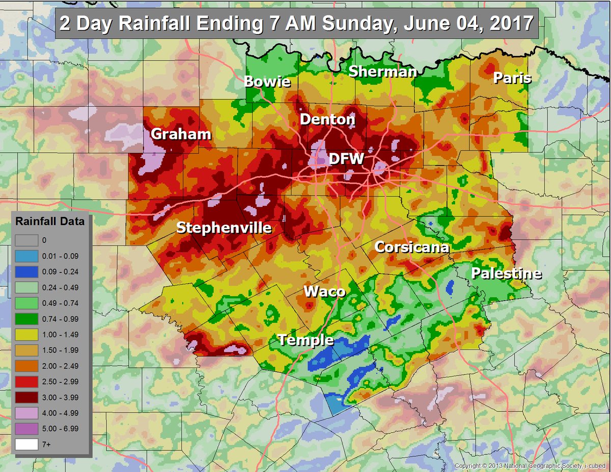
#100 Postby weatherdude1108 » Mon Jun 05, 2017 3:51 pm

JDawg512 wrote:
South Texas Storms wrote:
Ntxw wrote:DFW airport for the month of June (through 3 days not including today) is at a healthy 2.93". The month as a whole averages 3.79" so really another good shower will get us there so lets keep those tallies up! If June turns out wet (as it was in 2004 and 2007 with hefty rain totals) our summer will likely be much more subdued heat wise. I know the post is a little DFW centric but the weakness is effecting all of Texas so it's a symptom of a much larger pattern.


Unfortunately south central Texas has been largely missing out during this unsettled weather pattern. San Antonio and Austin are still below normal over the past month. Hopefully that will change soon.


Very true, my yard didn't even see half of what should have fallen for May. So far have received around 3 quarters of an inch for June. Other areas around have either seen more or a lot less. That's the downside to scattered activity, some areas miss out all together.

Looking ahead for the rest of this week it's not looking good. Let's hope today brings another good round.


Yeah, I received 2.25 inches from last Sunday to this past Saturday night, 1.5 of which fell this past Saturday night. I'm thankful, but this time of year, we need as much as we can get going into Summer. Maybe this stuff to the north will help us out, unless its outflow boundaries cut off the fuel source, making it a little breezy, causing them die out before they get here. Can't count how many times I have seen that happen. False hopes have made me cynical, but every storm is different. We'll see. EWX hints at some possible NW flow storms after this, but the surface flow from the north will cut off the source. They mention surface flow going southerly later in the week, making it more humid, but no mention of rain unfortunately. June is our second wettest month of the year, or at least it is supposed to me. :roll:

Image
Area Forecast Discussion
National Weather Service Austin/San Antonio TX
311 PM CDT Mon Jun 5 2017

.SHORT TERM (Tonight through Tuesday Night)...
The latest water vapor satellite loop continues to show cyclonic flow
aloft across south central Texas this afternoon. This will keep our
area in active northwest flow aloft for the next couple of days.
We
are already seeing some convection develop across the region with
daytime heating and we should continue to see at least scattered
convection through this evening for areas generally along and east of
Highway 281. A few strong to severe storms are possible with damaging
wind gusts and large hail the main concern. The latest mesoanalysis
shows a corridor of steeper low-level lapse rates oriented from deep
south Texas into the I-35 corridor.
This would tend to favor damaging
wind gusts, but as mentioned above we could certainly see some large
hail. With the loss of daytime heating, we should see a decrease in
the coverage of convection and we will only mention a low chance for
showers and storms near the coastal plains for the overnight hours.
On Tuesday, we will continue to see an active northwest flow aloft,
but should also see a decrease in moisture due to northerly flow in
the low-levels.
Northwest flow aloft can often produce convection and
with the onset of daytime heating, we will keep a low chance for
showers and storms for areas generally along and east of a Georgetown
to New Braunfels line. Similar to today, we should see a decrease in
convection Tuesday evening with the loss of daytime heating.

&&

.LONG TERM (Wednesday through Monday)...
For Wednesday and Thursday, we will continue to see northwest flow
aloft with northerly flow in the low-levels. While we can`t
completely rule out the possibility of some isolated convection
,
suspect the low-level drying will result in rain chances too low to
mention in the forecast.
On Friday, southerly flow in the low-levels
returns by late in the day. Southerly flow in the low-levels
continues for the upcoming weekend into early next week, while the
subtropical ridge axis begins to nudge in from the west. This will
result in near normal temperatures along with increasing humidity.
1 likes   
The preceding post is NOT an official forecast, and should not be used as such. It is only the opinion of the poster and may or may not be backed by sound meteorological data. It is NOT endorsed by any professional institution including storm2k.org. For Official Information please refer to the NHC and NWS products.


Return to “USA & Caribbean Weather”

Who is online

Users browsing this forum: No registered users and 10 guests