Tornado pictures

U.S. & Caribbean Weather Discussions and Severe Weather Events

Moderator: S2k Moderators

Forum rules

The posts in this forum are NOT official forecast and should not be used as such. They are just the opinion of the poster and may or may not be backed by sound meteorological data. They are NOT endorsed by any professional institution or STORM2K.

Help Support Storm2K
Message
Author
User avatar
Texas Snowman
Storm2k Moderator
Storm2k Moderator
Posts: 6011
Joined: Fri Jan 25, 2008 11:29 am
Location: Denison, Texas

Re: Tornado pictures

#41 Postby Texas Snowman » Tue Jun 08, 2010 10:12 pm

Wichita Falls, Texas tornado on April 10, 1979. Was a violent F4 that killed 45 people.

From Answers.com: "An F4 tornado struck the heavily populated southern sections of Wichita Falls in the late afternoon on Tuesday, April 10, 1979 (known locally as "Terrible Tuesday").[citation needed] The storm was part of an outbreak that produced 30 tornadoes around the region. Despite having nearly an hour's advance warning that severe weather was imminent, 45 people were killed (25 in vehicles) and 1,800 were injured because the storm arrived just in time for many people to be driving home from work.[citation needed] The tornado left 20,000 people homeless and caused $400 million in damage, a U.S. record not topped by an individual tornado until the F5 Moore-Oklahoma City tornado of May 3, 1999."

Image

Image

Image
0 likes   
The above post and any post by Texas Snowman is NOT an official forecast and should not be used as such. It is just the opinion of the poster and may or may not be backed by sound meteorological data. It is NOT endorsed by any professional institution including storm2k.org. For official information, please refer to NWS products.

User avatar
Texas Snowman
Storm2k Moderator
Storm2k Moderator
Posts: 6011
Joined: Fri Jan 25, 2008 11:29 am
Location: Denison, Texas

Re: Tornado pictures

#42 Postby Texas Snowman » Tue Jun 08, 2010 10:16 pm

Dallas, Texas tornado on April 2, 1957.

Image
0 likes   
The above post and any post by Texas Snowman is NOT an official forecast and should not be used as such. It is just the opinion of the poster and may or may not be backed by sound meteorological data. It is NOT endorsed by any professional institution including storm2k.org. For official information, please refer to NWS products.

User avatar
Texas Snowman
Storm2k Moderator
Storm2k Moderator
Posts: 6011
Joined: Fri Jan 25, 2008 11:29 am
Location: Denison, Texas

Re: Tornado pictures

#43 Postby Texas Snowman » Tue Jun 08, 2010 10:26 pm

Radar shot of Moore, Okla. about to be hit by F5 tornado on May 3, 1999.

Image
0 likes   
The above post and any post by Texas Snowman is NOT an official forecast and should not be used as such. It is just the opinion of the poster and may or may not be backed by sound meteorological data. It is NOT endorsed by any professional institution including storm2k.org. For official information, please refer to NWS products.

User avatar
Texas Snowman
Storm2k Moderator
Storm2k Moderator
Posts: 6011
Joined: Fri Jan 25, 2008 11:29 am
Location: Denison, Texas

Re: Tornado pictures

#44 Postby Texas Snowman » Tue Jun 08, 2010 10:30 pm

Bridge Creek radar shot - this is about the time the Norman NWS issued a tornado emergency for southern Oklahoma City on May 3, 1999.

Image
0 likes   
The above post and any post by Texas Snowman is NOT an official forecast and should not be used as such. It is just the opinion of the poster and may or may not be backed by sound meteorological data. It is NOT endorsed by any professional institution including storm2k.org. For official information, please refer to NWS products.

HurricaneBill
Category 5
Category 5
Posts: 3420
Joined: Sun Apr 11, 2004 5:51 pm
Location: East Longmeadow, MA, USA

Re: Tornado pictures

#45 Postby HurricaneBill » Wed Jun 09, 2010 3:29 am

June 9, 1953 (57 years ago)

Worcester, MA Tornado

F4 (some suspect it was an F5); 90 dead

Image
0 likes   

User avatar
brunota2003
S2K Supporter
S2K Supporter
Posts: 9476
Age: 33
Joined: Sat Jul 30, 2005 9:56 pm
Location: Stanton, KY...formerly Havelock, NC
Contact:

Re: Tornado pictures

#46 Postby brunota2003 » Wed Jun 09, 2010 7:18 am

Preliminary Event Summary
June 29, 2004

There was a very unusual tornado during the evening hours of June 29, 2004. The tornado was spotted in the vicinity of Kinston and tracked slowly westward towards LaGrange. It was a very weak tornado rated F0 on the Fujita scale. This landspout type funnel was associated with a low tropped tropical shower, which became more vigorous when it intereacted with the sea-breeze front. There was a visual confirmation of a touchdown near Kinston, with numerous reports of a rotating funnel from Lenoir County Emergency Management, spotters, local media. and the public. The tornado then went on to do very minor damage to a mobile home just east of LaGrange. There was only some weak rotation apparent on radar from the Raleigh NWS office radar. Interestingly, when the tornado/funnel was first occurring, no observations of lightning were detected, and there was not much vertical development of the storm. However, there was strong convergence of unstable air in the vicinity of the spin-up. After interacting with the sea-breeze, the convection intensified and lightning developed. One tornado warning was issued by the NWS in Newport for this event.

Image

Image

For a few more images:
http://www.erh.noaa.gov/mhx/EventReview ... 040629.php
0 likes   

User avatar
brunota2003
S2K Supporter
S2K Supporter
Posts: 9476
Age: 33
Joined: Sat Jul 30, 2005 9:56 pm
Location: Stanton, KY...formerly Havelock, NC
Contact:

Re: Tornado pictures

#47 Postby brunota2003 » Wed Jun 09, 2010 7:28 am

Preliminary Event Summary
June 7, 2004

On June 7, 2004, There was a stationary front oriented east to west across Carteret County. There was sufficient instability for the development of convection along and near this boundary. Wind profiles were favorable for waterspout or weak tornadic development. During the late morning, a tornado developed near this boundary over Open Grounds Farm. Later in the afternoon, a waterspout developed near Davis in Core Sound and moved ashore. Both were in sparsely populated areas and did no damage. The Newport/Morehead City NWS Office issued 2 Tornado Warnings for Downeast Carteret County for these two events.

This photo is personally one of my favorite all time tornado photos:

Image

SEA MONSTER!!!

Image

There are a few more photos here of this and the other tornado:
http://www.erh.noaa.gov/mhx/EventReview ... 040607.php


An event on June 4, 2004 produced a couple tornadoes in NE NC

Image

Damage to a marina it hit:

Image

More photos and details:
http://www.erh.noaa.gov/mhx/EventReview ... 040604.php
0 likes   

User avatar
thetruesms
Professional-Met
Professional-Met
Posts: 844
Age: 40
Joined: Thu Aug 16, 2007 1:14 pm
Location: Tallahasee, FL
Contact:

Re: Tornado pictures

#48 Postby thetruesms » Wed Jun 09, 2010 11:10 am

vbhoutex wrote:IIRC, Parkersburg was completely destroyed and has not been rebuilt.
Nope, it's still there and rebuilding. Although tragedy struck them again last year when their iconic football coach (several of his players are currently in the NFL) was murdered by a former student :(
0 likes   

User avatar
vbhoutex
Storm2k Executive
Storm2k Executive
Posts: 28972
Age: 72
Joined: Wed Oct 09, 2002 11:31 pm
Location: Spring Branch area, Houston, TX
Contact:

Re: Tornado pictures

#49 Postby vbhoutex » Wed Jun 09, 2010 1:30 pm

thetruesms wrote:
vbhoutex wrote:IIRC, Parkersburg was completely destroyed and has not been rebuilt.
Nope, it's still there and rebuilding. Although tragedy struck them again last year when their iconic football coach (several of his players are currently in the NFL) was murdered by a former student :(

Was there another EF5 up in that part of the country in the last 2 years? I distinctly remember a show talking about the town not being rebuilt. It was a very small town, maybe in SD or ND.
0 likes   
Skywarn, C.E.R.T.
Please click below to donate to STORM2K to help with the expenses of keeping the site going:
Image

User avatar
thetruesms
Professional-Met
Professional-Met
Posts: 844
Age: 40
Joined: Thu Aug 16, 2007 1:14 pm
Location: Tallahasee, FL
Contact:

Re: Tornado pictures

#50 Postby thetruesms » Wed Jun 09, 2010 3:47 pm

vbhoutex wrote:Was there another EF5 up in that part of the country in the last 2 years? I distinctly remember a show talking about the town not being rebuilt. It was a very small town, maybe in SD or ND.
Last EF5 before that was Greensburg, whose rebuilding got a cable series. Before that, you have to predate the EF scale for a 5, and go back to May 3, 1999.

Perhaps you're thinking of the 2008 Picher, OK tornado? I know that the tornado, combined with the fact that it's a superfund site ended up resulting in the town's closure.
0 likes   

User avatar
Aquawind
Category 5
Category 5
Posts: 6714
Age: 60
Joined: Mon Jun 16, 2003 10:41 pm
Location: Salisbury, NC
Contact:

Re: Tornado pictures

#51 Postby Aquawind » Wed Jun 09, 2010 4:43 pm

Manchester, SD

http://en.wikipedia.org/wiki/Manchester,_South_Dakota

As of 2007, the town lies barren and abandoned. There are no plans to rebuild. All that currently remains of Manchester is the slab foundations of demolished houses and the wind-twisted town limits sign, sitting in a sea of empty farmland. Manchester is now an official natural disaster ghost town. Although empty and depopulated, Manchester has not been "wiped off the map" yet, as it remains on both the government rolls and maps pending the next Federal census.


Image
0 likes   

User avatar
dizzyfish
S2K Supporter
S2K Supporter
Posts: 1511
Joined: Fri Sep 16, 2005 7:56 am
Location: New Port Richey, FL

Re: Tornado pictures

#52 Postby dizzyfish » Thu Jun 10, 2010 5:25 am

Holy crap - that gives me goose bumps! :uarrow:
0 likes   

AyameTaylor
Tropical Wave
Tropical Wave
Posts: 3
Joined: Tue Jun 08, 2010 10:23 am

Re: Tornado pictures

#53 Postby AyameTaylor » Thu Jun 10, 2010 9:03 am

brunota2003 wrote:
Image

SEA MONSTER!!!

Image


Holy crap :eek:THOSE give me goose bumps Great pics-- Is it just me or does that tornado look like some thing out of a horror movie-- like crappy cgi done right?
0 likes   

User avatar
brunota2003
S2K Supporter
S2K Supporter
Posts: 9476
Age: 33
Joined: Sat Jul 30, 2005 9:56 pm
Location: Stanton, KY...formerly Havelock, NC
Contact:

Re: Tornado pictures

#54 Postby brunota2003 » Thu Jun 10, 2010 6:05 pm

AyameTaylor wrote:
Holy crap :eek:THOSE give me goose bumps Great pics-- Is it just me or does that tornado look like some thing out of a horror movie-- like crappy cgi done right?

Haha! Especially the second one. As I said, the first one is one of my favorites (because you can see the inside of it and it looks really cool :lol: ). Luckily, it was in a field and only rated as an F0!
0 likes   

Nicko999
Category 5
Category 5
Posts: 1744
Joined: Thu Sep 24, 2009 2:49 pm
Location: Montreal

Re: Tornado pictures

#55 Postby Nicko999 » Thu Jun 10, 2010 9:10 pm

Elie, Manitoba (Canada :wink: ) June 22, 2007

Canada's only F5 tornado to date.

Image

Image

Image
0 likes   
Image

AyameTaylor
Tropical Wave
Tropical Wave
Posts: 3
Joined: Tue Jun 08, 2010 10:23 am

Re: Tornado pictures

#56 Postby AyameTaylor » Fri Jun 11, 2010 11:13 am

These are some more cool video's from Youtube.

[youtube]http://www.youtube.com/watch?v=rBd0sG559aA[/youtube]

[youtube]http://www.youtube.com/watch?v=r4iofIQTX7o&feature=related[/youtube]

[youtube]http://www.youtube.com/watch?v=6UmxSzWaLPc&feature=channel[/youtube]

[youtube]http://www.youtube.com/watch?v=PVUNTW3VBPw&feature=related[/youtube]

[youtube]http://www.youtube.com/watch?v=F64epWjf80o&feature=related[/youtube]

[youtube]http://www.youtube.com/watch?v=TTxTWc0ShAg[/youtube]

[youtube]http://www.youtube.com/watch?v=Tv8PciVvYEo&feature=channel[/youtube]
0 likes   

HurricaneBill
Category 5
Category 5
Posts: 3420
Joined: Sun Apr 11, 2004 5:51 pm
Location: East Longmeadow, MA, USA

Re: Tornado pictures

#57 Postby HurricaneBill » Fri Jun 11, 2010 10:23 pm

International tornadoes:

2009 Rajkanika Tornado (India)

[youtube]http://www.youtube.com/watch?v=G0y1xOrUiFA[/youtube]

2006 Waterspout moves onshore in Sydney and becomes a tornado (Australia)

[youtube]http://www.youtube.com/watch?v=ngbWU1GuCfM[/youtube]

2005 Wedge tornado in Sao Paulo (Brazil)

http://www.youtube.com/watch?v=v-8m6vYkSFk
0 likes   

User avatar
Bunkertor
Category 5
Category 5
Posts: 3386
Joined: Tue May 09, 2006 3:48 pm

Re: Tornado pictures

#58 Postby Bunkertor » Thu Jul 15, 2010 4:38 am

edit
0 likes   

User avatar
artist
Category 5
Category 5
Posts: 9793
Joined: Mon Jun 06, 2005 3:26 pm
Location: West Palm

Re: Tornado pictures

#59 Postby artist » Thu Jul 15, 2010 9:12 am

Image

Image

Image
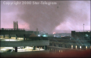
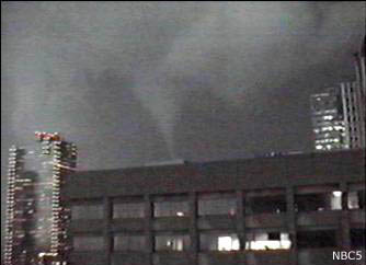
Ft. Worth tornado March 28, 2000

here is a link to photos of the destruction-
http://www.jeberly.com/PhotosByJohnEber ... 000-2.html
one example -
Image
0 likes   

User avatar
KWT
Category 5
Category 5
Posts: 31390
Joined: Tue Aug 17, 2004 11:02 am
Location: UK!!!

#60 Postby KWT » Thu Jul 15, 2010 10:26 am

Some amazing videos there online...

The UK isn't well known for decent strength tornadoes, get mainly weak ones though we've had a few F2s recently and there have been suspected F3-F4s in the past as well...

Also whilst rare we do sometimes get outbreaks, maybe not to the same strength as the US of course but our biggest outbreak was 105 tornadoes in the space of just *6hrs* in 1981 with the strongest being an F2

Longest single track was by a borderline F2/3 was 107kms, but it went far further as a funnel cloud.
0 likes   
Personal Forecast Disclaimer:
The posts in this forum are NOT official forecast and should not be used as such. They are just the opinion of the poster and may or may not be backed by sound meteorological data. They are NOT endorsed by any professional institution or storm2k.org. For official information, please refer to the NHC and NWS products


Return to “USA & Caribbean Weather”

Who is online

Users browsing this forum: No registered users and 27 guests