http://www.noaanews.noaa.gov/stories201 ... ought.html


Moderator: S2k Moderators


Stephanie wrote:The South always seems to be in a drought!

vbhoutex wrote:Stephanie wrote:The South always seems to be in a drought!
How well I know! Doing the weekly watering to try and get the grass to grow after the cold dry winter.


Shoshana wrote:We got less than an inch at our house in Austin. When will this La Nina go away?!?@?


vbhoutex wrote:Even thought we have had rain in Texas today, I don't expect it to change the map much, if any next week. We didn't get enough rain to break a drought, at least not here in SE TX. If this keeps up we'll just change our climate type to "Texas desert".
 my Cowboys my Rockets my Astros

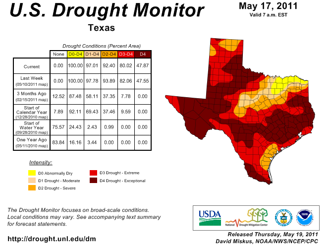

southerngale wrote:vbhoutex wrote:Even thought we have had rain in Texas today, I don't expect it to change the map much, if any next week. We didn't get enough rain to break a drought, at least not here in SE TX. If this keeps up we'll just change our climate type to "Texas desert".
1/3 of an inch won't even put a dent in it. Our part of Texas didn't get squat! I wouldn't be surprised to see the remaining areas in SE TX that are in Extreme join their neighbors in Exceptional.
I am glad that some people in Texas got a decent amount of rain. Hopefully, everyone will soon.


Return to “USA & Caribbean Weather”
Users browsing this forum: Cpv17, Google Adsense [Bot], Ralph's Weather, South Texas Storms and 151 guests


