http://www.wfaa.com/news/texas-news/Spr ... 83055.html
2012 U.S Severe Weather (Videos-Photos-Stats-Forecasts)
Moderator: S2k Moderators
Forum rules

The posts in this forum are NOT official forecast and should not be used as such. They are just the opinion of the poster and may or may not be backed by sound meteorological data. They are NOT endorsed by any professional institution or STORM2K.
-
HockeyTx82
- S2K Supporter

- Posts: 1986
- Joined: Tue Oct 27, 2009 11:17 am
- Location: Ponder, TX
Massive Hail Storm in Texas Panhandle
I was not sure if this should go under the winter weather board or here. Either way 
http://www.wfaa.com/news/texas-news/Spr ... 83055.html
http://www.wfaa.com/news/texas-news/Spr ... 83055.html
0 likes
Don't hold me accountable for anything I post on this forum. Leave the real forecasting up to the professionals.
Location: Ponder, TX (all observation posts are this location unless otherwise noted)
Location: Ponder, TX (all observation posts are this location unless otherwise noted)
-
cycloneye

- Admin

- Posts: 139068
- Age: 67
- Joined: Thu Oct 10, 2002 10:54 am
- Location: San Juan, Puerto Rico
Re: Massive Hail Storm in Texas Panhandle
Hi. I merged this thread to the main 2012 Severe Season thread where all the 2012 videos are being posted.
viewtopic.php?f=24&t=112438&p=2218991#p2218991
viewtopic.php?f=24&t=112438&p=2218991#p2218991
0 likes
Visit the Caribbean-Central America Weather Thread where you can find at first post web cams,radars
and observations from Caribbean basin members Click Here
and observations from Caribbean basin members Click Here


MDT ?
SPC considering upgrade for TODAY
http://www.spc.noaa.gov/products/outlook/day1otlk.html
VIRTUALLY ALL MODEL SOLUTIONS HAVE CONVERGED ON THE DEVELOPMENT OF
ISOLATED DISCRETE SUPERCELLS ALONG THE SURFACE DRYLINE THIS
AFTERNOON FROM NORTHEAST CO INTO FAR WESTERN KS. FORECAST SOUNDINGS
APPEAR QUITE FAVORABLE FOR TORNADIC SUPERCELLS CAPABLE OF VERY LARGE
HAIL AND DAMAGING WINDS. HAVE ALSO ADDED SIGNIFICANT TORNADO
PROBABILITIES ACROSS THIS REGION AS COMBINATION OF STEEP LOW LEVEL
LAPSE RATES...STRONG LOW LEVEL VERTICAL SHEAR...AND DISCRETE MODE
ENHANCE THE RISK OF STRONG TORNADOES GENERALLY BETWEEN 22-02Z. THE
MAIN CONCERN FOR UPGRADING TO MODERATE IS THE LIKELY WIDE SPACING OF
STORMS AND LIMITED AREAL COVERAGE. THIS WILL BE RE-EVALUATED AT
20Z.
0 likes
-
cycloneye
- Admin
- Posts: 139068
- Age: 67
- Joined: Thu Oct 10, 2002 10:54 am
- Location: San Juan, Puerto Rico
Re: 2012 U.S Severe Weather Season (Stats / Videos / Forecasts)
I suspect that after all the event of this weekend is over and the stats are compiled,the 2012 totals will jump bigtime moving closer and closer to the 2011 numbers.
0 likes
Visit the Caribbean-Central America Weather Thread where you can find at first post web cams,radars
and observations from Caribbean basin members Click Here
and observations from Caribbean basin members Click Here
-
brunota2003

- S2K Supporter
- Posts: 9476
- Age: 33
- Joined: Sat Jul 30, 2005 9:56 pm
- Location: Stanton, KY...formerly Havelock, NC
- Contact:
Re: 2012 U.S Severe Weather Season (Stats / Videos / Forecasts)
Just figured I would post this here:
brunota2003 wrote:Just to give you guys an idea of the energy associated with this system, there were several severe thunderstorm warnings yesterday in California, including one for the San Bruno/San Francisco area. The one that hit SF had good rotation on radar before it came ashore, and they were lucky a waterspout didn't move ashore, or that it didn't strengthen and try to drop a tornado on them.
0 likes
-
cycloneye
- Admin
- Posts: 139068
- Age: 67
- Joined: Thu Oct 10, 2002 10:54 am
- Location: San Juan, Puerto Rico
Re: 2012 U.S Severe Weather Season (Stats / Videos / Forecasts)
Will this weekend's event surpass the number of tornadoes the March 2, 2012 event of 160?
http://www.spc.noaa.gov/climo/reports/120302_rpts.html
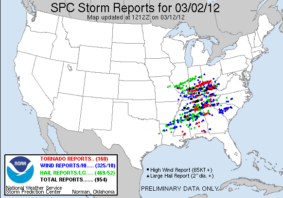
http://www.spc.noaa.gov/climo/reports/120302_rpts.html
0 likes
Visit the Caribbean-Central America Weather Thread where you can find at first post web cams,radars
and observations from Caribbean basin members Click Here
and observations from Caribbean basin members Click Here
-
CrazyC83
- Professional-Met

- Posts: 33393
- Joined: Tue Mar 07, 2006 11:57 pm
- Location: Deep South, for the first time!
Re: 2012 U.S Severe Weather Season (Stats / Videos / Forecasts)
cycloneye wrote:Will this weekend's event surpass the number of tornadoes the March 2, 2012 event of 160?
http://www.spc.noaa.gov/climo/reports/120302_rpts.html
Tomorrow alone could easily surpass it IMO.
0 likes
-
cycloneye
- Admin
- Posts: 139068
- Age: 67
- Joined: Thu Oct 10, 2002 10:54 am
- Location: San Juan, Puerto Rico
Re: 2012 U.S Severe Weather Season (Stats / Videos / Forecasts)
Days 4-8 Outlook issued on 4/14/12
The good news is that after this weekend's outbreak,there will be a pause of a few days.
DAY 4-8 CONVECTIVE OUTLOOK
NWS STORM PREDICTION CENTER NORMAN OK
0359 AM CDT SAT APR 14 2012
VALID 171200Z - 221200Z
...DISCUSSION...
THE MEDIUM RANGE MODELS BEGIN THE DAY 4 TO 8 PERIOD WITH AN
UPPER-LEVEL TROUGH OVER THE SCNTRL U.S. AND MOVE THIS FEATURE ACROSS
THE GULF COAST STATES TUESDAY/DAY 4 INTO TUESDAY NIGHT. A THREAT FOR
STRONG THUNDERSTORMS COULD EXIST ACROSS THE LOWER MS VALLEY AND EWD
ALONG THE GULF COAST TUESDAY AFTERNOON. ON WEDNESDAY/DAY 5...THE
MODELS DEVELOP WNWLY FLOW ACROSS THE CNTRL STATES AND RETURN SOME
LOW-LEVEL MOISTURE INTO THE SRN PLAINS. ON THURSDAY/DAY 6...THE
MODELS CONTINUE MOISTURE ADVECTION ACROSS THE GREAT PLAINS MOVING AN
UPPER-LEVEL TROUGH INTO THE REGION FROM THE WEST. THIS ALONG WITH
THE DEVELOPMENT OF MODERATE INSTABILITY COULD SUPPORT A SEVERE
THREAT WITH STORMS THAT INITIATE ACROSS THE SRN AND CNTRL PLAINS.
THE POTENTIAL FOR STRONG THUNDERSTORMS WOULD SHIFT EWD INTO THE
ARKLATEX AND MID MS VALLEY ON FRIDAY/DAY 7 WITH A CHANCE FOR AN
ENHANCED SEVERE THREAT THERE AS WELL. AT THIS POINT...THE SYNOPTIC
SETUP AND CONVECTIVE ENVIRONMENT ON THURSDAY AFTERNOON AND EVENING
IN THE SRN AND CNTRL PLAINS APPEARS FAVORABLE FOR SEVERE STORMS.
HOWEVER...CONFIDENCE IS NOT GREAT ENOUGH TO INTRODUCE A SEVERE
THREAT AREA ON DAY 6 OR DAY 7.
..BROYLES.. 04/14/2012

Uploaded with imageshack.us
The good news is that after this weekend's outbreak,there will be a pause of a few days.
DAY 4-8 CONVECTIVE OUTLOOK
NWS STORM PREDICTION CENTER NORMAN OK
0359 AM CDT SAT APR 14 2012
VALID 171200Z - 221200Z
...DISCUSSION...
THE MEDIUM RANGE MODELS BEGIN THE DAY 4 TO 8 PERIOD WITH AN
UPPER-LEVEL TROUGH OVER THE SCNTRL U.S. AND MOVE THIS FEATURE ACROSS
THE GULF COAST STATES TUESDAY/DAY 4 INTO TUESDAY NIGHT. A THREAT FOR
STRONG THUNDERSTORMS COULD EXIST ACROSS THE LOWER MS VALLEY AND EWD
ALONG THE GULF COAST TUESDAY AFTERNOON. ON WEDNESDAY/DAY 5...THE
MODELS DEVELOP WNWLY FLOW ACROSS THE CNTRL STATES AND RETURN SOME
LOW-LEVEL MOISTURE INTO THE SRN PLAINS. ON THURSDAY/DAY 6...THE
MODELS CONTINUE MOISTURE ADVECTION ACROSS THE GREAT PLAINS MOVING AN
UPPER-LEVEL TROUGH INTO THE REGION FROM THE WEST. THIS ALONG WITH
THE DEVELOPMENT OF MODERATE INSTABILITY COULD SUPPORT A SEVERE
THREAT WITH STORMS THAT INITIATE ACROSS THE SRN AND CNTRL PLAINS.
THE POTENTIAL FOR STRONG THUNDERSTORMS WOULD SHIFT EWD INTO THE
ARKLATEX AND MID MS VALLEY ON FRIDAY/DAY 7 WITH A CHANCE FOR AN
ENHANCED SEVERE THREAT THERE AS WELL. AT THIS POINT...THE SYNOPTIC
SETUP AND CONVECTIVE ENVIRONMENT ON THURSDAY AFTERNOON AND EVENING
IN THE SRN AND CNTRL PLAINS APPEARS FAVORABLE FOR SEVERE STORMS.
HOWEVER...CONFIDENCE IS NOT GREAT ENOUGH TO INTRODUCE A SEVERE
THREAT AREA ON DAY 6 OR DAY 7.
..BROYLES.. 04/14/2012
Uploaded with imageshack.us
0 likes
Visit the Caribbean-Central America Weather Thread where you can find at first post web cams,radars
and observations from Caribbean basin members Click Here
and observations from Caribbean basin members Click Here
-
cycloneye
- Admin
- Posts: 139068
- Age: 67
- Joined: Thu Oct 10, 2002 10:54 am
- Location: San Juan, Puerto Rico
Re: 2012 U.S Severe Weather Season (Stats / Videos / Forecasts)
I think is better to have this 4/14 graphic without uploading with imageshack.us so the peeps can see it updating at this sticky thread rather than on the Plains Outbreak thread, as there will be plenty of activity and it gets lost on the pages there. Is eerie to see it without any reports at the time I am posting this,but how many reports will be up is the question when all is set and done.

0 likes
Visit the Caribbean-Central America Weather Thread where you can find at first post web cams,radars
and observations from Caribbean basin members Click Here
and observations from Caribbean basin members Click Here
-
cycloneye
- Admin
- Posts: 139068
- Age: 67
- Joined: Thu Oct 10, 2002 10:54 am
- Location: San Juan, Puerto Rico
Re: 2012 U.S Severe Weather Season (Stats / Videos / Forecasts)
These are the live feeds from the stormchasers in the area. Posting it here because is more easy to find as the Plains thread is very busy and it gets lost in the pages.
http://www.tornadovideos.net/pages/full_screen/
http://www.tornadovideos.net/pages/full_screen/
0 likes
Visit the Caribbean-Central America Weather Thread where you can find at first post web cams,radars
and observations from Caribbean basin members Click Here
and observations from Caribbean basin members Click Here
-
cycloneye
- Admin
- Posts: 139068
- Age: 67
- Joined: Thu Oct 10, 2002 10:54 am
- Location: San Juan, Puerto Rico
Re: 2012 Severe Weather:See updating SPC Graph and Stormchasers
As of the time of this post 54 preliminary reports of Tornadoes have been confirmed. Will this outbreak be as predicted?
0 likes
Visit the Caribbean-Central America Weather Thread where you can find at first post web cams,radars
and observations from Caribbean basin members Click Here
and observations from Caribbean basin members Click Here
-
cycloneye
- Admin
- Posts: 139068
- Age: 67
- Joined: Thu Oct 10, 2002 10:54 am
- Location: San Juan, Puerto Rico
Re: 2012 U.S Severe Weather Season (Stats / Videos / Forecasts)
Here are videos of the 4/14/12 outbreak,these in Kansas.
http://www.youtube.com/watch?v=USCZsUEA ... r_embedded
http://www.youtube.com/watch?v=USCZsUEA ... r_embedded
0 likes
Visit the Caribbean-Central America Weather Thread where you can find at first post web cams,radars
and observations from Caribbean basin members Click Here
and observations from Caribbean basin members Click Here
-
cycloneye
- Admin
- Posts: 139068
- Age: 67
- Joined: Thu Oct 10, 2002 10:54 am
- Location: San Juan, Puerto Rico
Re: 2012 U.S Severe Weather Season (Stats / Videos / Forecasts)
Nothing big in terms of another outbreak at least for the next 4-8 days.
DAY 4-8 CONVECTIVE OUTLOOK
NWS STORM PREDICTION CENTER NORMAN OK
0336 AM CDT SUN APR 15 2012
VALID 181200Z - 231200Z
...DISCUSSION...
BOTH THE GFS AND ECMWF ARE IN GENERAL AGREEMENT THROUGH MID WEEK
REGARDING THE OVERALL PATTERN ACROSS THE CONUS. BEYOND THURSDAY THE
GFS IS CONSIDERABLY MORE AGGRESSIVE IN THE EVOLUTION OF ERN U.S.
TROUGH AS IT DIGS INTO THE MID SOUTH.
PRIOR TO THE AFOREMENTIONED MODEL DIVERGENCE...FLOW WILL INCREASE A
BIT ACROSS THE SRN/CNTRL PLAINS WITHIN THE BASE OF THE PROGRESSIVE
TROUGH. IT APPEARS A FRONTAL SURGE WILL OCCUR ACROSS THE PLAINS
WHICH WILL FORCE A BOUNDARY ACROSS KS INTO OK ON THURSDAY. IF
SUFFICIENT MOISTURE/INSTABILITY CAN ESTABLISH ITSELF ACROSS THIS
REGION BY DAY5 THEN THERE IS SOME CONCERN THAT ROBUST STORMS MAY
DEVELOP ACROSS THIS REGION. HOWEVER...PREDICTABILITY IS A BIT TOO
LOW REGARDING THIS SCENARIO TO WARRANT A SIGNIFICANT SEVERE RISK AT
THIS TIME. BEYOND DAY5 TOO MUCH UNCERTAINTY EXISTS WITHIN THE MODEL
GUIDANCE ACROSS THE GULF STATES TO SUPPORT A SEVERE RISK.
0 likes
Visit the Caribbean-Central America Weather Thread where you can find at first post web cams,radars
and observations from Caribbean basin members Click Here
and observations from Caribbean basin members Click Here
-
cycloneye
- Admin
- Posts: 139068
- Age: 67
- Joined: Thu Oct 10, 2002 10:54 am
- Location: San Juan, Puerto Rico
Re: 2012 U.S Severe Weather Season (Stats / Videos / Forecasts)
That's ok my friend.  Eventually,many videos will also be posted in this main 2012 thread to have the most videos as possible of all the big severe events of this 2012 season to document it.
This is what every family has to have in their homes in a threat of tornadoes.

This is what every family has to have in their homes in a threat of tornadoes.
0 likes
Visit the Caribbean-Central America Weather Thread where you can find at first post web cams,radars
and observations from Caribbean basin members Click Here
and observations from Caribbean basin members Click Here
-
cycloneye
- Admin
- Posts: 139068
- Age: 67
- Joined: Thu Oct 10, 2002 10:54 am
- Location: San Juan, Puerto Rico
Re: 2012 U.S Severe Weather Season (Stats / Videos / Forecasts)
Here is the April 15 graphic that is updating so you can see how many preliminary reports of Tornadoes are up.
0 likes
Visit the Caribbean-Central America Weather Thread where you can find at first post web cams,radars
and observations from Caribbean basin members Click Here
and observations from Caribbean basin members Click Here
-
cycloneye
- Admin
- Posts: 139068
- Age: 67
- Joined: Thu Oct 10, 2002 10:54 am
- Location: San Juan, Puerto Rico
Re: 2012 U.S Severe Weather Season (Stats / Videos / Forecasts)
Impressive video of the Salina,Kansas Tornado that lasts 4:22.
http://www.youtube.com/watch?v=p6uoM_z3 ... r_embedded
http://www.youtube.com/watch?v=p6uoM_z3 ... r_embedded
0 likes
Visit the Caribbean-Central America Weather Thread where you can find at first post web cams,radars
and observations from Caribbean basin members Click Here
and observations from Caribbean basin members Click Here
-
cycloneye
- Admin
- Posts: 139068
- Age: 67
- Joined: Thu Oct 10, 2002 10:54 am
- Location: San Juan, Puerto Rico
Re: 2012 U.S Severe Weather Season (Stats / Videos / Forecasts)
Days 4-8 Outlook issued on 4/16/12
Still nothing like a big outbreak on the horizon at least for the next few days.
DAY 4-8 CONVECTIVE OUTLOOK
NWS STORM PREDICTION CENTER NORMAN OK
0334 AM CDT MON APR 16 2012
VALID 191200Z - 241200Z
...DISCUSSION...
GFS AND ECMWF ARE IN GENERAL AGREEMENT REGARDING THE EVOLUTION OF AN
UPPER TROUGH AS IT DIGS SEWD ACROSS THE PLAINS AND DEEPENS OVER THE
SERN U.S. THIS WEEKEND. EARLY IN THE DIGGING PHASE ACROSS THE
PLAINS THERE IS SOME CONCERN THAT STRONG THUNDERSTORMS COULD EVOLVE
ALONG A SURGING COLD FRONT ACROSS OK DAY4 AND OVER TX/LOWER MS
VALLEY DAY5. AT THIS TIME IT/S NOT CLEAR THAT SUFFICIENT
INSTABILITY WILL BE IN PLACE AHEAD OF WIND SHIFT TO WARRANT A RISK
OF WIDESPREAD ORGANIZED SEVERE THUNDERSTORMS. THE GFS IS A BIT
FASTER WITH THE TROUGH AND SFC FRONT INTO CNTRL OK THURSDAY
AFTERNOON AND SUGGESTS A NARROW AXIS OF INSTABILITY MAY BE IN PLACE
TO SUPPORT A SMALL CORRIDOR OF SEVERE INTO THE EVENING HOURS. IF
LATER MODEL GUIDANCE CONTINUES TO SUPPORT THIS SOLUTION THEN SEVERE
PROBS MAY NEED TO BE INCLUDED ACROSS PARTS OF THE SRN PLAINS
THURSDAY AND PERHAPS DOWNSTREAM INTO THE LOWER MS VALLEY FRIDAY.
..DARROW.. 04/16/2012
0 likes
Visit the Caribbean-Central America Weather Thread where you can find at first post web cams,radars
and observations from Caribbean basin members Click Here
and observations from Caribbean basin members Click Here
Return to “USA & Caribbean Weather”
Who is online
Users browsing this forum: Brent and 138 guests