Texas Spring-2015
Moderator: S2k Moderators
Forum rules

The posts in this forum are NOT official forecast and should not be used as such. They are just the opinion of the poster and may or may not be backed by sound meteorological data. They are NOT endorsed by any professional institution or STORM2K.

Lake Texoma is back over the spillway. It has never topped the spillway twice in the same year that wasn't continuous.
0 likes
The above post and any post by Ntxw is NOT an official forecast and should not be used as such. It is just the opinion of the poster and may or may not be backed by sound meteorological data. It is NOT endorsed by any professional institution including Storm2k. For official information, please refer to NWS products.
Help support Storm2K!
-
vbhoutex

- Storm2k Executive

- Posts: 28974
- Age: 72
- Joined: Wed Oct 09, 2002 11:31 pm
- Location: Spring Branch area, Houston, TX
- Contact:
Re: Texas Spring-2015
We're pretty much in the same shape as Austin rain wise. Email from Jeff Lindner.
Texas has had just about everything thrown at it over the last few months…rainfall wise… and much like the staggering lack of rain in 2011, 2015 is already going down as one of the wettest years ever on record…no surprise we have been dealing with flooding and a lot of it.
The most impressive statistic is for the City of Baytown. Baytown has recorded 54.15 inches of rain to date this year which is an impressive +31.77 inches above normal. The entire annual rainfall for Baytown is 59.92 inches. Only 5.77 inches to reach their yearly average rainfall and it is only June 18th.
The City of Brenham have surpassed their annual average rainfall of 45.14 inches. As of June 18th, Brenham has recorded 45.77 inches of rainfall.
The City of Crockett has recorded 40.30 inches of rainfall through today. The previous January 1-June 18th rainfall recorded was 35.36 inches in 1935
The City of Sugar Land has recorded 41.96 inches of rainfall in 2015 which is +21.21 inches above normal. 20.40 inches fell in the month of May alone (+15.77 above normal for May) or 49% of the 41.96 inches fell in May. The 8.04 inches on May 25th was 39% of the May monthly total and 19% of the 2015 total. The 4 day combined rainfall from May 24-27 was 11.45 inches or 27% of the 2015 total in only 4 days. The 20-day period from the 11-30 of May recorded a staggering 20.32 inches of rain or 48% of the 2015 total. Of the 20 days rain fell on each day except 4.
January 1-June 18th Rainfall (Normal yearly rainfall):
BUSH IAH: 34.62 (49.77)
Hobby: 38.48 (54.65)
College Station: 31.09 (40.06)
Baytown: 54.15 (59.92)
Bellville: 37.83 (41.75)
Brenham: 45.77 (45.14)
Crockett: 40.30 (45.18)
Westbury: 39.49 (51.82)
Huntsville: 41.48 (49.08)
NWS League City: 42.57 (56.81)
Richmond: 38.47 (49.08)
Washing State Park: 41.05 (41.68)
BUSH IAH is currently running 12.71 inches above normal for 2015
Houston Hobby is currently running 15.93 inches above normal for 2015
The City of Conroe has recorded 29.76 inches of rainfall in 2015 which is 8.42 inches above normal.
0 likes
Skywarn, C.E.R.T.
Please click below to donate to STORM2K to help with the expenses of keeping the site going:

Please click below to donate to STORM2K to help with the expenses of keeping the site going:
-
1900hurricane

- Category 5

- Posts: 6044
- Age: 32
- Joined: Fri Feb 06, 2015 12:04 pm
- Location: Houston, TX
- Contact:
Lake Texoma has to be seeing some insane inflows. The gauges immediately upstream on both the Red and Washita Rivers recorded their highest stages for their periods of record today.
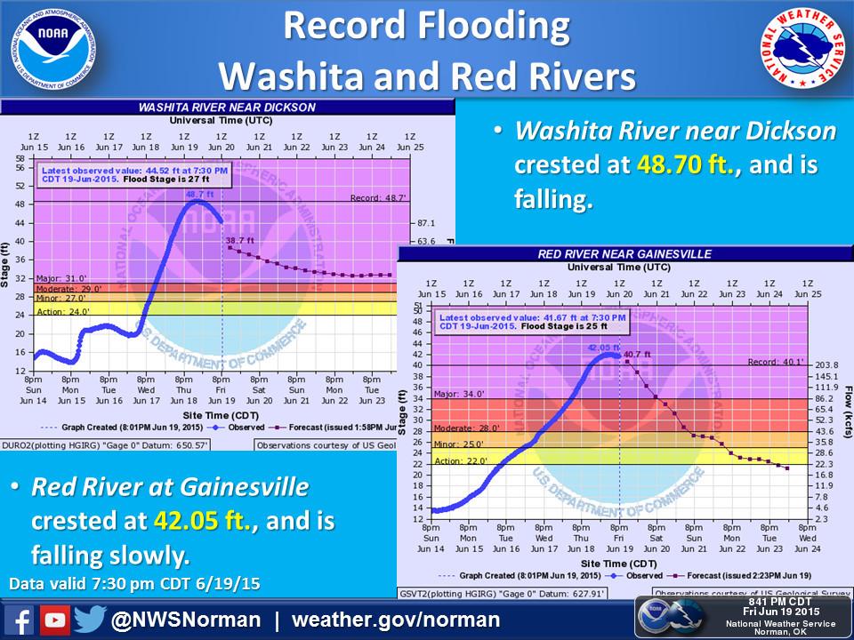
(Image from the NWS Norman Twitter page)
(Image from the NWS Norman Twitter page)
0 likes
Contract Meteorologist. TAMU & MSST. Fiercely authentic, one of a kind. We are all given free will, so choose a life meant to be lived. We are the Masters of our own Stories.
Opinions expressed are mine alone.
Follow me on Twitter at @1900hurricane : Read blogs at https://1900hurricane.wordpress.com/
Opinions expressed are mine alone.
Follow me on Twitter at @1900hurricane : Read blogs at https://1900hurricane.wordpress.com/
-
vbhoutex
- Storm2k Executive
- Posts: 28974
- Age: 72
- Joined: Wed Oct 09, 2002 11:31 pm
- Location: Spring Branch area, Houston, TX
- Contact:
Re: Texas Spring-2015
Insane flows on the Red River. Saw on the news today that it is almost up to the roadway on the I35 bridge. Those bridges are built so that supposedly they will never be topped by the river flows. Just completely insane!!
0 likes
Skywarn, C.E.R.T.
Please click below to donate to STORM2K to help with the expenses of keeping the site going:
Please click below to donate to STORM2K to help with the expenses of keeping the site going:


El Nino is about to deal another hand of weather likely effecting July 4th events. The atmosphere is going steriods far far away from us but will have impacts. Happy summer solstice, especially to our resident heat Miser. I think its time we shift discussions over to the summer thread.
0 likes
The above post and any post by Ntxw is NOT an official forecast and should not be used as such. It is just the opinion of the poster and may or may not be backed by sound meteorological data. It is NOT endorsed by any professional institution including Storm2k. For official information, please refer to NWS products.
Help support Storm2K!
Help support Storm2K!


Re: Texas Spring-2015
Okay this is a bit off topic but it does have to do with the flooding a long the Red River and I need to ask those of you that live near it about this.
My sister lives in Shreveport and in fact some of you might have seen her on the news as she has been on both local and regional as well as on the national news. Her name is Kellie Simpson. I was on the phone with her yesterday and she told me she has been in contact with the mayor and her staff as well as with Senator Bill Cassidy and she was told some of the water may be diverted to two reservoirs that apparently still have room to hold water and that the crest won't be as bad through Shreveport as what we've seen upstream.
My question is do any of you know what resaviors/lakes that they are referring to? I had not heard of any lakes in that area that are not at capacity but I figured this would be a good place to ask fellow forumers who live in north/northeast Texas.
My sister and her neighbors are really not sure what to expect and how high the river will crest this time around. Again I apologize for this post getting off the weather specific topic. Any help would be much appreciated and thanks.
0 likes
Resident Rain Miser
I am a weather hobbyist living 3.5 miles south of Downtown Austin and in no way or fashion should anything I say concerning forecasts be taken seriously. Please check your local NWS for accurate weather forecasting and conditions.
I am a weather hobbyist living 3.5 miles south of Downtown Austin and in no way or fashion should anything I say concerning forecasts be taken seriously. Please check your local NWS for accurate weather forecasting and conditions.
Re: Texas Spring-2015
vbhoutex wrote:Insane flows on the Red River. Saw on the news today that it is almost up to the roadway on the I35 bridge. Those bridges are built so that supposedly they will never be topped by the river flows. Just completely insane!!
The I35 bridge is down to 2 lanes, I think it's northbound that's closed because of deck damage and the southbound is two way. The I75/69 bridge is closed completely because of flooding just north of the bridge.
0 likes
-
aggiecutter
- Category 5
- Posts: 1743
- Joined: Thu Oct 14, 2004 9:22 pm
- Location: Texarkana
Re: Texas Spring-2015
JDawg512 wrote:Okay this is a bit off topic but it does have to do with the flooding a long the Red River and I need to ask those of you that live near it about this.
My sister lives in Shreveport and in fact some of you might have seen her on the news as she has been on both local and regional as well as on the national news. Her name is Kellie Simpson. I was on the phone with her yesterday and she told me she has been in contact with the mayor and her staff as well as with Senator Bill Cassidy and she was told some of the water may be diverted to two reservoirs that apparently still have room to hold water and that the crest won't be as bad through Shreveport as what we've seen upstream.
My question is do any of you know what resaviors/lakes that they are referring to? I had not heard of any lakes in that area that are not at capacity but I figured this would be a good place to ask fellow forumers who live in north/northeast Texas.
My sister and her neighbors are really not sure what to expect and how high the river will crest this time around. Again I apologize for this post getting off the weather specific topic. Any help would be much appreciated and thanks.
First of all, there are no reservoirs to divert any water to on the Red River between Lake Texoma and Shreveport. The are 2 reservoirs(one just north and one just south of Texarkana) that could hold water back if needed. Millwood Lake, just north of Texarkana, recently started releasing water again. Millwood could shut their flood gates again as the lake has not reached its flood capacity. The same can be said for Wright Patman lake south of Texarkana. Wright Patman is on the Sulphur River in NE Texas and flows into the Red River near the Arkansas-Louisiana border. Millwood Lake is located on the Little River in SW Arkansas and flows into the Red River just west of Fulton, Arkansas.
There is also Broken Bow Lake in SE Oklahoma and Dequeen Lake in the northern part of SW Arkansas. However, those 2 lakes don't have as big an impact on the water level of the Red River as the other 2 that I mentioned. If you want to keep up with the current level and forecast crest of the Red River at various locations, use the link below:
http://water.weather.gov/ahps2/index.php?wfo=shv
0 likes
Re: Texas Spring-2015
aggiecutter wrote:JDawg512 wrote:Okay this is a bit off topic but it does have to do with the flooding a long the Red River and I need to ask those of you that live near it about this.
My sister lives in Shreveport and in fact some of you might have seen her on the news as she has been on both local and regional as well as on the national news. Her name is Kellie Simpson. I was on the phone with her yesterday and she told me she has been in contact with the mayor and her staff as well as with Senator Bill Cassidy and she was told some of the water may be diverted to two reservoirs that apparently still have room to hold water and that the crest won't be as bad through Shreveport as what we've seen upstream.
My question is do any of you know what resaviors/lakes that they are referring to? I had not heard of any lakes in that area that are not at capacity but I figured this would be a good place to ask fellow forumers who live in north/northeast Texas.
My sister and her neighbors are really not sure what to expect and how high the river will crest this time around. Again I apologize for this post getting off the weather specific topic. Any help would be much appreciated and thanks.
First of all, there are no reservoirs to divert any water to on the Red River between Lake Texoma and Shreveport. The are 2 reservoirs(one just north and one just south of Texarkana) that could hold water back if needed. Millwood Lake, just north of Texarkana, recently started releasing water again. Millwood could shut their flood gates again as the lake has not reached its flood capacity. The same can be said for Wright Patman lake south of Texarkana. Wright Patman is on the Sulphur River in NE Texas and flows into the Red River near the Arkansas-Louisiana border. Millwood Lake is located on the Little River in SW Arkansas and flows into the Red River just west of Fulton, Arkansas.
There is also Broken Bow Lake in SE Oklahoma and Dequeen Lake in the northern part of SW Arkansas. However, those 2 lakes don't have as big an impact on the water level of the Red River as the other 2 that I mentioned. If you want to keep up with the current level and forecast crest of the Red River at various locations, use the link below:
http://water.weather.gov/ahps2/index.php?wfo=shv
Thank you very much for the info.
I was also confused about the term they used by diverting water but I do believe they meant what you said.
Again I appreciate it very much.
0 likes
Resident Rain Miser
I am a weather hobbyist living 3.5 miles south of Downtown Austin and in no way or fashion should anything I say concerning forecasts be taken seriously. Please check your local NWS for accurate weather forecasting and conditions.
I am a weather hobbyist living 3.5 miles south of Downtown Austin and in no way or fashion should anything I say concerning forecasts be taken seriously. Please check your local NWS for accurate weather forecasting and conditions.
Lets move the good discussion over to the Summer thread to help folks not having to look back and forth  thanks
0 likes
The above post and any post by Ntxw is NOT an official forecast and should not be used as such. It is just the opinion of the poster and may or may not be backed by sound meteorological data. It is NOT endorsed by any professional institution including Storm2k. For official information, please refer to NWS products.
Help support Storm2K!
Help support Storm2K!
Return to “USA & Caribbean Weather”
Who is online
Users browsing this forum: No registered users and 71 guests