Texas Spring 2017

U.S. & Caribbean Weather Discussions and Severe Weather Events

Moderator: S2k Moderators

Forum rules

The posts in this forum are NOT official forecast and should not be used as such. They are just the opinion of the poster and may or may not be backed by sound meteorological data. They are NOT endorsed by any professional institution or STORM2K.

Help Support Storm2K
Message
Author
User avatar
bubba hotep
S2K Supporter
S2K Supporter
Posts: 5454
Joined: Wed Dec 28, 2016 1:00 am
Location: Collin County Texas

Re: Texas Spring 2017

#1301 Postby bubba hotep » Fri May 26, 2017 11:11 pm

Brent wrote:the NAM has an MCS/line moving from Oklahoma into DFW and east in the predawn hours Sunday.


I would be ok with that.
0 likes   
Winter time post are almost exclusively focused on the DFW area.

User avatar
bubba hotep
S2K Supporter
S2K Supporter
Posts: 5454
Joined: Wed Dec 28, 2016 1:00 am
Location: Collin County Texas

Re: Texas Spring 2017

#1302 Postby bubba hotep » Sat May 27, 2017 8:39 am

FWD has been able to basically just copy and paste this the last couple of months... Die CAP!!! Regardless of what the models show in the medium range systems keep tracking too far north to provide adequate large scale lift to break things or they have the worst possible timing.

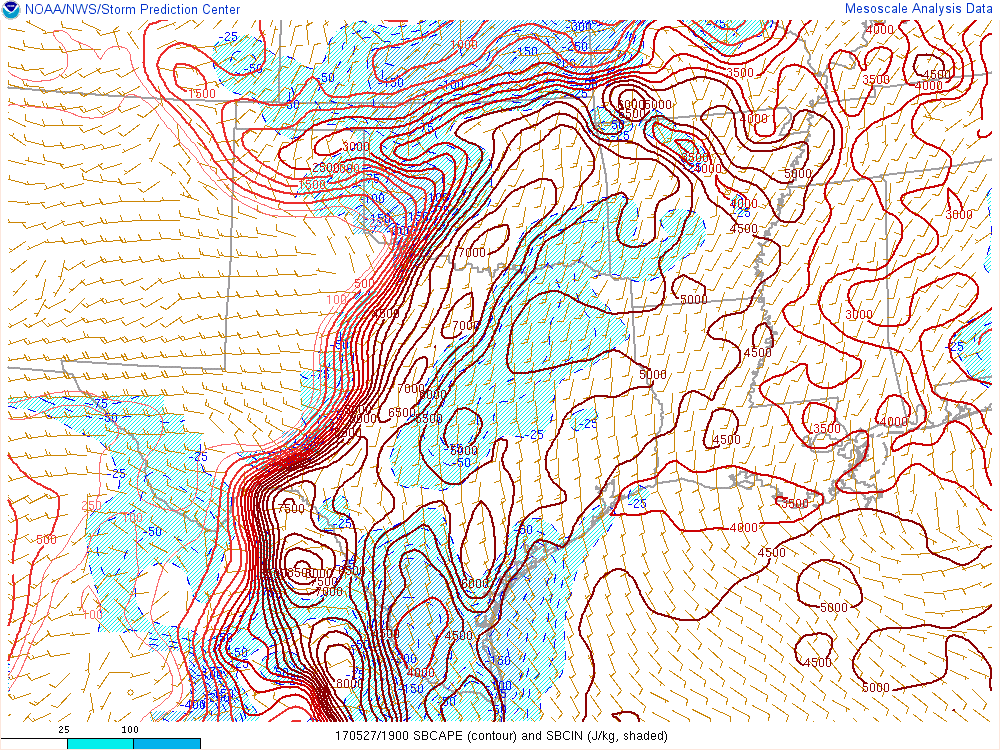
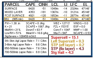
By late afternoon, the dryline will advect toward our western
zones, although its eastward progress may be hampered by the
fairly deep moisture layer which will not be able mix out very
quickly. There is still concern over a low potential for storms to
develop along the dryline by late afternoon, although initiation
will be a challenge given there should still be a stout cap in
place with a lack of large-scale ascent.
If a storm or two were
able to initiate and sustain themselves into the favorable air
east of the dryline, they would likely become severe as a
supercellular storm mode would be favored given the shear
parameters. The aformentioned warm/moist boundary layer will
result in several thousand J/kg of SBCAPE which would be
incredibly favorable for any discrete storms if they`re able to
survive in a capped environment. Very large hail would be the
primary threat with this activity, although damaging winds and an
isolated tornado would be possible too. While the thermodynamics
are certainly quite favorable for severe weather, the question
remains whether any storms will be able to initiate whatsoever.
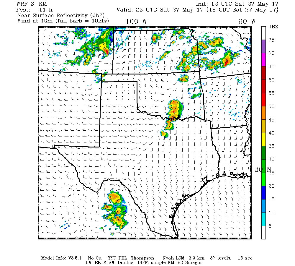
Most CAM solutions make much more sense than yesterday morning`s
runs which had previously been igniting widespread dryline
convection within the forecast area. Most models this morning are
much more reluctant to do so and many keep us completely dry
through the evening hours. Given the cap and lack of ascent, a
dry forecast actually seems like the best bet and it seems quite
possible that the environment will squander the extreme
instability in place today, at least regarding dryline convection.
Have left low PoPs as the threat for this convection to develop
is still non-zero.
0 likes   
Winter time post are almost exclusively focused on the DFW area.

Brent
S2K Supporter
S2K Supporter
Posts: 37087
Age: 35
Joined: Sun May 16, 2004 10:30 pm
Location: Tulsa Oklahoma
Contact:

Re: Texas Spring 2017

#1303 Postby Brent » Sat May 27, 2017 10:52 am

Lol the cap again

and the GFS went drier later in the week. It begins again.
0 likes   
#neversummer

User avatar
bubba hotep
S2K Supporter
S2K Supporter
Posts: 5454
Joined: Wed Dec 28, 2016 1:00 am
Location: Collin County Texas

Re: Texas Spring 2017

#1304 Postby bubba hotep » Sat May 27, 2017 11:35 am

HRRR is pretty locked in on no dryline action and the MCS missing DFW to the NE. Looks mostly dry & hot and then dry & muggy.
0 likes   
Winter time post are almost exclusively focused on the DFW area.

Brent
S2K Supporter
S2K Supporter
Posts: 37087
Age: 35
Joined: Sun May 16, 2004 10:30 pm
Location: Tulsa Oklahoma
Contact:

Re: Texas Spring 2017

#1305 Postby Brent » Sat May 27, 2017 12:10 pm

bubba hotep wrote:HRRR is pretty locked in on no dryline action and the MCS missing DFW to the NE. Looks mostly dry & hot and then dry & muggy.


Story of the spring. :roll:
0 likes   
#neversummer

User avatar
bubba hotep
S2K Supporter
S2K Supporter
Posts: 5454
Joined: Wed Dec 28, 2016 1:00 am
Location: Collin County Texas

Re: Texas Spring 2017

#1306 Postby bubba hotep » Sat May 27, 2017 3:03 pm

Per SPC meso, CAPE is pushing 7000+ in areas just west of DFW and the cap looks to be weakening pretty substantially. Now, will there be even the slightest trigger of a ripple in the flow? Texas Tech fires storms but not seeing any other CAMs pulling the trigger.

Image

Texas Tech hasn't totally given up yet with the 12z trying a come back

Image
0 likes   
Winter time post are almost exclusively focused on the DFW area.

User avatar
hriverajr
Professional-Met
Professional-Met
Posts: 786
Joined: Tue Jul 19, 2005 12:16 am

Re: Texas Spring 2017

#1307 Postby hriverajr » Sat May 27, 2017 3:22 pm

Feels like Corpus here in Del Rio.. Temp 93 dewpoint 75... yuck
0 likes   

Yukon Cornelius
S2K Supporter
S2K Supporter
Posts: 1737
Age: 40
Joined: Thu Dec 20, 2012 9:23 pm
Location: Dean, TX/Westcliffe, CO

Re: Texas Spring 2017

#1308 Postby Yukon Cornelius » Sat May 27, 2017 3:27 pm

Temp 98. Dewpoint 69. Heat Index 104. Sucks!
2 likes   
#neversummer

gpsnowman
S2K Supporter
S2K Supporter
Posts: 2711
Joined: Fri Jan 07, 2011 10:35 am
Location: Grand Prairie Tx

Re: Texas Spring 2017

#1309 Postby gpsnowman » Sat May 27, 2017 3:31 pm

The humidity is so thick, you can slice it with a knife. The towers in Las Colinas looked to be in a layer of fog from a distance. Just disgusting. Who could ever enjoy this type of weather??
3 likes   

User avatar
hriverajr
Professional-Met
Professional-Met
Posts: 786
Joined: Tue Jul 19, 2005 12:16 am

Re: Texas Spring 2017

#1310 Postby hriverajr » Sat May 27, 2017 3:34 pm

97 T... 77 DP... heat index 111.. not going outside lol
0 likes   

User avatar
bubba hotep
S2K Supporter
S2K Supporter
Posts: 5454
Joined: Wed Dec 28, 2016 1:00 am
Location: Collin County Texas

Re: Texas Spring 2017

#1311 Postby bubba hotep » Sat May 27, 2017 4:25 pm

Tornado watch in Oklahoma down to the Red River but some signs of life along the dryline in N. Texas

 https://twitter.com/whatisthisrds/status/868578692020228097


0 likes   
Winter time post are almost exclusively focused on the DFW area.

User avatar
hriverajr
Professional-Met
Professional-Met
Posts: 786
Joined: Tue Jul 19, 2005 12:16 am

Re: Texas Spring 2017

#1312 Postby hriverajr » Sat May 27, 2017 4:57 pm

That dryline to the west of DFW is almost out of time to pop a storm.
1 likes   
Anything I post is my personal opinion and should not used for any type of planning or lifesaving reasons. Please refer to National Weather Service forecasts.

User avatar
bubba hotep
S2K Supporter
S2K Supporter
Posts: 5454
Joined: Wed Dec 28, 2016 1:00 am
Location: Collin County Texas

Re: Texas Spring 2017

#1313 Postby bubba hotep » Sat May 27, 2017 5:43 pm

hriverajr wrote:That dryline to the west of DFW is almost out of time to pop a storm.


Area b/w Ringgold and Jacksboro making one last run at it but areas south of that are thinning out. Like you said, running short on time now, esp. since not even a failed attempt yet.

ETA: They didn't last, maybe time for another attempt?

From Ardmore, OK looking SW, pic from @VORTEXJeff

Image
1 likes   
Winter time post are almost exclusively focused on the DFW area.

User avatar
South Texas Storms
Professional-Met
Professional-Met
Posts: 4003
Joined: Thu Jun 24, 2010 12:28 am
Location: Houston, TX

Re: Texas Spring 2017

#1314 Postby South Texas Storms » Sat May 27, 2017 6:02 pm

Elevated rain chances will return to the forecast tomorrow and continue through much of next week as an unsettled weather pattern develops across the region. A few strong to severe storms will be possible late tomorrow, with the main concern transitioning over to flash flooding later in the week as the southern half of Texas will likely receive several rounds of rain over the next 7 days. Some areas could see over 5 inches of rain by next weekend.

The latest WPC QPF map sure looks more like the Euro and I would love for it to verify.
Last edited by South Texas Storms on Sat May 27, 2017 6:08 pm, edited 2 times in total.
0 likes   

User avatar
bubba hotep
S2K Supporter
S2K Supporter
Posts: 5454
Joined: Wed Dec 28, 2016 1:00 am
Location: Collin County Texas

Re: Texas Spring 2017

#1315 Postby bubba hotep » Sat May 27, 2017 6:05 pm

SPC chimes in:

Image

Mesoscale Discussion 0877
NWS Storm Prediction Center Norman OK
0600 PM CDT Sat May 27 2017

Areas affected...Portions of North Texas

Concerning...Severe potential...Watch possible

Valid 272300Z - 280030Z

Probability of Watch Issuance...40 percent

SUMMARY...Portions of north Texas are being monitored for
thunderstorm development. A substantial conditional (upon
development) severe risk exists and watch issuance is possible.

DISCUSSION...Towering cumulus have recently been noted near the Red
River across portions of north TX. While large-scale forcing is weak
at best across this area, continued convergence in the vicinity of a
diffuse dryline may result in storm development during the next 1-2
hours. Steep midlevel lapse rates atop a very warm and moist
boundary layer are resulting in extreme buoyancy, with MLCAPE likely
approaching 6000 J/kg in some areas. With moderately strong
southwesterly midlevel flow across the region, effective shear is
more than sufficient for supercells, and any storms that develop
will have a threat of giant hail and localized, but potentially
significant, wind gusts. While low-level flow, as sampled by area
VWPs, is not overly strong, some tornado threat would also exist
given the extreme CAPE environment and some expected intensification
of the low-level jet later this evening.

It is unclear how many storms, if any, will develop in the short
term across this area, but watch issuance may become necessary if
initiation appears imminent.

..Dean/Guyer.. 05/27/2017
1 likes   
Winter time post are almost exclusively focused on the DFW area.

User avatar
bubba hotep
S2K Supporter
S2K Supporter
Posts: 5454
Joined: Wed Dec 28, 2016 1:00 am
Location: Collin County Texas

Re: Texas Spring 2017

#1316 Postby bubba hotep » Sat May 27, 2017 7:29 pm

The northern cell maintained and is off to the races but the southern updrafts died as soon as they moved off the dryline and out over the cap. Now the HRRR is pushing the MCS down into the northern portions of DFW later tonight but it is totally missing the current cluster near Ardmore, OK...
0 likes   
Winter time post are almost exclusively focused on the DFW area.

Brent
S2K Supporter
S2K Supporter
Posts: 37087
Age: 35
Joined: Sun May 16, 2004 10:30 pm
Location: Tulsa Oklahoma
Contact:

Re: Texas Spring 2017

#1317 Postby Brent » Sat May 27, 2017 10:06 pm

are we ever gonna get a fropa at a favorable time of day? Lol to me that's the biggest problem other than the super cap... they always come through in the morning and were lucky to get some dying leftovers

We obviously can't rely on the cap to break from another way
Last edited by Brent on Sat May 27, 2017 10:11 pm, edited 1 time in total.
0 likes   
#neversummer

User avatar
bubba hotep
S2K Supporter
S2K Supporter
Posts: 5454
Joined: Wed Dec 28, 2016 1:00 am
Location: Collin County Texas

Re: Texas Spring 2017

#1318 Postby bubba hotep » Sat May 27, 2017 10:09 pm

At 00z there was still a strong cap in place but plenty of CAPE, if an MCS can organize and make the southward push. Per latest SPC meso, Supercell Composite Parameter is over 20 now for areas east of I35 (don't know if we should laugh or cry)

From the 00z FWD sounding
Image
0 likes   
Winter time post are almost exclusively focused on the DFW area.

Brent
S2K Supporter
S2K Supporter
Posts: 37087
Age: 35
Joined: Sun May 16, 2004 10:30 pm
Location: Tulsa Oklahoma
Contact:

Re: Texas Spring 2017

#1319 Postby Brent » Sat May 27, 2017 10:20 pm

Heh I just noticed DFW only got to 80 this morning... if that holds it will tie the record for warmest May low from 2008(and 4 degrees above record from 2006)
0 likes   
#neversummer

User avatar
bubba hotep
S2K Supporter
S2K Supporter
Posts: 5454
Joined: Wed Dec 28, 2016 1:00 am
Location: Collin County Texas

Re: Texas Spring 2017

#1320 Postby bubba hotep » Sat May 27, 2017 10:28 pm

Brent wrote:Heh I just noticed DFW only got to 80 this morning... if that holds it will tie the record for warmest May low from 2008(and 4 degrees above record from 2006)


Filthy
0 likes   
Winter time post are almost exclusively focused on the DFW area.


Return to “USA & Caribbean Weather”

Who is online

Users browsing this forum: 869MB, AnnularCane, Iceresistance and 60 guests