Texas Spring 2017
Moderator: S2k Moderators
Forum rules

The posts in this forum are NOT official forecast and should not be used as such. They are just the opinion of the poster and may or may not be backed by sound meteorological data. They are NOT endorsed by any professional institution or STORM2K.
Re: Texas Spring 2017
DFW is now 1.1F above normal. Given we will warm the next few days through the end of the month prospect of having a below normal month in forever is now becoming a distant dream. It will likely be above normal continuing the streak however it's not as warm relative to the other months we've seen. Rainfall at the airport has been an endangered phenomenon with 0.53" in a month that should see near 5" total. So unless some freak thunderstorm sits over the airport and just pours, this Spring overall will be well above normal and drier than normal with March and May both below while April was a little above. In terms of numbers DFW March-April-May typically sees 11.46" of rain, with a few days to go we are sitting 4.97"
0 likes
The above post and any post by Ntxw is NOT an official forecast and should not be used as such. It is just the opinion of the poster and may or may not be backed by sound meteorological data. It is NOT endorsed by any professional institution including Storm2k. For official information, please refer to NWS products.
Help support Storm2K!
-
Ralph's Weather
- S2K Supporter

- Posts: 2968
- Age: 36
- Joined: Fri Dec 13, 2013 11:55 am
- Location: Lindale, TX
Re: Texas Spring 2017
A beautiful 52 this morning. Too bad the warm up starts today with near 90 expected for the next few days before more storms come late this holiday weekend.
0 likes
Follow on Facebook at Ralph's Weather.
-
bubba hotep

- S2K Supporter
- Posts: 5456
- Joined: Wed Dec 28, 2016 1:00 am
- Location: Collin County Texas
Re: Texas Spring 2017
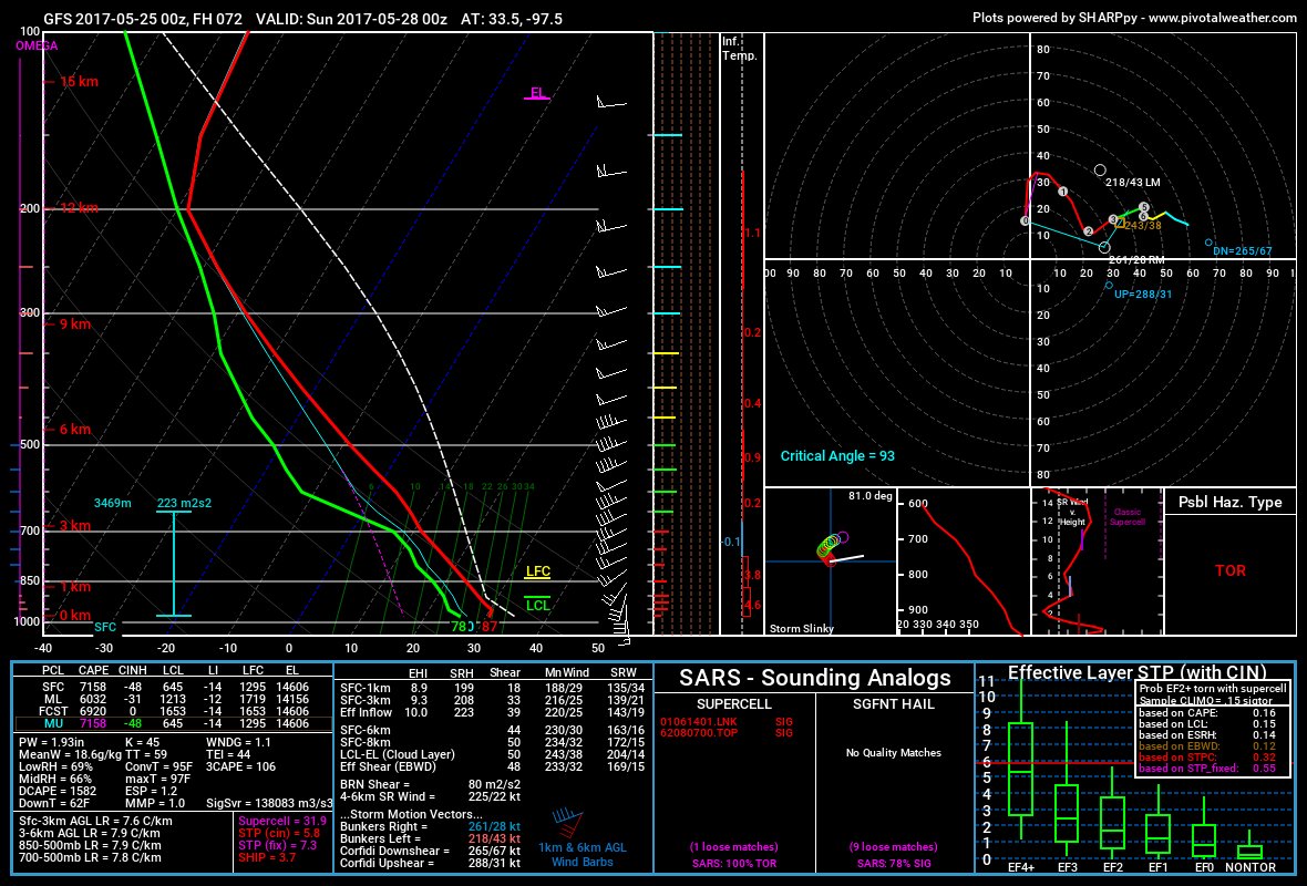
Both the 00z Euro and GFS look to initiate convection along the dryline on Saturday with the Euro maintaining some signal indicating storms survive and move off the dryline. The GFS appears to fire storms but it appears they aren't able to penetrate the cap and aren't able to maintain updrafts off the dryline. Extreme CAPE comes with a strong cap, so this isn't surprising but if storms can get surface based as they move off the dryline then all modes of svr wx would be possible with giant hail almost guaranteed.

0 likes
Winter time post are almost exclusively focused on the DFW area.

Re: Texas Spring 2017
New Goes 16 stuff
https://weather.msfc.nasa.gov/GOES/
If you zoom in great great detail.. updated every 5 minutes
https://weather.msfc.nasa.gov/GOES/
If you zoom in great great detail.. updated every 5 minutes
1 likes
-
gboudx

- S2K Supporter
- Posts: 4047
- Joined: Thu Sep 04, 2003 1:39 pm
- Location: Rockwall, Tx but from Harvey, La
Re: Texas Spring 2017
Update from Jeff Lindner:
Prolonged period of active weather to begin this weekend and last through all of next week.
Ridging across the region behind the departing storm system of early this week will give way to an increasingly trough type pattern by late this weekend over the southern plains. This will allow another cold front to sag into SE TX and stall around Monday and then linger for much of next week. Global models are actually in fairly good agreement on this pattern and its blocky nature keeping a wet and active pattern through the end of May and into early June.
Moisture levels will begin to increase on Friday across the region as southerly winds increase. BY Sunday PWS will be rising toward 1.6 inches and nearing 2.0 inches on Monday. WSW upper level flow will help to track disturbances across the region starting late Sunday through much of next week. Global models are showing strong convective signals Sunday into Monday over the Rio Grande Plains SW of San Antonio where some sort of nearly stationary thunderstorm complex may evolve out of NE MX.
Persons traveling to SC/SW TX for the Memorial Day weekend should be very aware of the risk for rapid flash flooding along normally low flowing creeks and rivers. Have a way to get warnings and know what actions to take if flash flooding approaches your location…these are the two big lessons from the Wimberley Flash Flood on Memorial Day weekend 2015.
Meso scale processes take over moving into Memorial Day and beyond with numerous outflow boundaries and upper air disturbances helping to focus additional thunderstorms and storm complexes.
Pattern is heavily pointing toward a flash flood risk at some point…possibly as early as Sunday night out across the Rio Grande plains and SC TX and then across much of the southern half of the state Monday onward into next week. It is too early to be overly concerned, but the prolonged nature of the stalled out upper air pattern, tropical moisture in place, and stalled boundaries all point to heavy rainfall accumulations for much of next week.
Severe threat will also be possible starting Sunday and then onward with enough instability and weak to moderate shear in place. We are pretty far out in time to really assess the full severe potential, but it is late May and thunderstorms this time of year can readily produce severe weather.
1 likes
-
Portastorm

- Storm2k Moderator

- Posts: 9787
- Age: 61
- Joined: Fri Jul 11, 2003 9:16 am
- Location: South Austin, TX
- Contact:
Re: Texas Spring 2017
Ntxw wrote:DFW is now 1.1F above normal. Given we will warm the next few days through the end of the month prospect of having a below normal month in forever is now becoming a distant dream. It will likely be above normal continuing the streak however it's not as warm relative to the other months we've seen. Rainfall at the airport has been an endangered phenomenon with 0.53" in a month that should see near 5" total. So unless some freak thunderstorm sits over the airport and just pours, this Spring overall will be well above normal and drier than normal with March and May both below while April was a little above. In terms of numbers DFW March-April-May typically sees 11.46" of rain, with a few days to go we are sitting 4.97"
I have not checked the precip numbers but through Thursday, Austin was averaging 0.3 to 0.5 BELOW normal on temperatures.
0 likes
Any forecasts under my name are to be taken with a grain of salt. Get your best forecasts from the National Weather Service and National Hurricane Center.
I'm a certified Advanced SKYWARN-trained spotter and am active on Twitter at @TravisCOSW, a social media partner of the NWS Austin-San Antonio office.
I'm a certified Advanced SKYWARN-trained spotter and am active on Twitter at @TravisCOSW, a social media partner of the NWS Austin-San Antonio office.
Re: Texas Spring 2017
Portastorm wrote:Ntxw wrote:DFW is now 1.1F above normal. Given we will warm the next few days through the end of the month prospect of having a below normal month in forever is now becoming a distant dream. It will likely be above normal continuing the streak however it's not as warm relative to the other months we've seen. Rainfall at the airport has been an endangered phenomenon with 0.53" in a month that should see near 5" total. So unless some freak thunderstorm sits over the airport and just pours, this Spring overall will be well above normal and drier than normal with March and May both below while April was a little above. In terms of numbers DFW March-April-May typically sees 11.46" of rain, with a few days to go we are sitting 4.97"
I have not checked the precip numbers but through Thursday, Austin was averaging 0.3 to 0.5 BELOW normal on temperatures.
You are correct sir and both are somewhere around 1-2" below normal.precip. 90s the next few days will nudge to average to near or slightly above normal. But overall a pretty typical May temp wise at KAUS
0 likes
The above post and any post by Ntxw is NOT an official forecast and should not be used as such. It is just the opinion of the poster and may or may not be backed by sound meteorological data. It is NOT endorsed by any professional institution including Storm2k. For official information, please refer to NWS products.
Help support Storm2K!
Help support Storm2K!
Re: Texas Spring 2017
"Moisture levels will begin to increase on Friday across the region as southerly winds increase. BY Sunday PWS will be rising toward 1.6 inches and nearing 2.0 inches on Monday. WSW upper level flow will help to track disturbances across the region starting late Sunday through much of next week. Global models are showing strong convective signals Sunday into Monday over the Rio Grande Plains SW of San Antonio where some sort of nearly stationary thunderstorm complex may evolve out of NE MX." Watching this in Del Rio
1 likes
Anything I post is my personal opinion and should not used for any type of planning or lifesaving reasons. Please refer to National Weather Service forecasts.
-
Tireman4

- S2K Supporter
- Posts: 5674
- Age: 58
- Joined: Fri Jun 30, 2006 1:08 pm
- Location: Humble, Texas
- Contact:
Re: Texas Spring 2017
000
FXUS64 KHGX 251714
AFDHGX
Area Forecast Discussion
National Weather Service Houston/Galveston TX
1214 PM CDT Thu May 25 2017
.AVIATION...
VFR conds expected through 06z. MVFR cigs expected to develop as
low level moisture increases beneath a strong capping inversion.
HRRR is showing IFR cigs developing west of Houston by 08z.
Confidence is low with regard to IFR development. Fcst soundings
keep MVFR cigs in place for much of Friday with cigs mixing out
between 18-20z. Winds will remain gusty this afternoon and drop
slightly overnight but never fully decouple with gusty winds
expected again on Friday. 43
&&
.PREV DISCUSSION... /ISSUED 1102 AM CDT Thu May 25 2017/
UPDATE...
Another gorgeous morning under sunny skies and a brisk southwest
to south wind, upper 70 regional temperatures. Moisture will
return through the day, increasing cloudiness from the west during
the overnight early Friday morning hours. Increased cloud cover
and winds staying up at around 10 mph should provide enough
insulation and mixing, respectively, to regulate Friday minTs to
the lower to middle 70s. Very low rain chances Saturday will begin
to reach chance categories Sunday. The target window for the area
receiving rainfall will be from Sunday evening through Memorial
Day. A shortwave trough passage with the best upper level support
occurs early Monday. As of now, QPF values are low with the
highest QPF of around half of an inch to an inch being focused
across the northern third of the CWA through early Tuesday. A
slow-moving surface boundary sagging into a southeastern Texas
near 2 inch pwat air mass Monday is certainly a situation that
needs to be monitored for the potential for high rainfall going
into the weekend. 31
PREV DISCUSSION... /ISSUED 439 AM CDT Thu May 25 2017/
DISCUSSION...
Cool/quiet conditions across SE TX this morning. As the surface
high moves off to the east...we should see onshore winds return
through this afternoon. Warmer temps expected the next few days
along with increasing moisture levels (as S/SE winds strengthen
in response to a low pressure moving into the Southern Plains).
Highs in the lower 90s with lows in the 70s should prevail.
No real forecast issues are expected for SE TX until the latter
part of the upcoming weekend. The system moving into the Southern
Plains will help to drag a cold front into the state on Sat and
the boundary should eventually make its way into the northern
portions of our CWFA by Sun night. The flattened upper flow will
likely keep the front over the area which will then act as a focus
for wet/active weather for perhaps much of next week. PWs are
progged to around 2" as a series of shortwaves approach from the
west. Extended models have been fairly consistent with this
scenario these last few days, so will continue to keep elevated
POPS in for this time frame. 41
MARINE...
Onshore winds will quickly strengthen during the day today as the
pressure gradient tightens in response to developing low pressure in
the lee of the Rockies. A moderate onshore flow will prevail through
the weekend with low pressure over West Texas and high pressure over
the eastern Gulf of Mexico. A SCEC will likely be required at times
through the weekend, with SCA conditions possible overnight tonight
into Friday morning. A weak cold front will approach SE TX Sunday
night but is not forecast to make it off the coast. Lighter onshore
flow is forecast for the beginning of next week. 11
&&
.PRELIMINARY POINT TEMPS/POPS...
College Station (CLL) 90 72 91 76 92 / 0 0 10 10 10
Houston (IAH) 88 74 89 78 91 / 0 0 10 10 10
Galveston (GLS) 84 78 85 80 85 / 0 0 10 10 10
&&
.HGX WATCHES/WARNINGS/ADVISORIES...
TX...NONE.
GM...SMALL CRAFT SHOULD EXERCISE CAUTION until 7 PM CDT this evening
for the following zones: Coastal waters from Freeport to
the Matagorda Ship Channel out 20 NM...Coastal waters from
High Island to Freeport out 20 NM...Galveston Bay...
Matagorda Bay...Waters from Freeport to the Matagorda Ship
Channel from 20 to 60 NM...Waters from High Island to
Freeport from 20 to 60 NM.
&&
$$
Discussion...31
Aviation/Marine...43
0 likes
-
Brent
- S2K Supporter
- Posts: 37091
- Age: 35
- Joined: Sun May 16, 2004 10:30 pm
- Location: Tulsa Oklahoma
- Contact:
Re: Texas Spring 2017
The 12z GFS has gone wet with 2-4 inches in DFW before the month is over(looks like the front stalls further north?)
The 12z Euro says what rain? Only a tenth of an inch of rain through Wednesday. Given the airport's luck... I'll go with the Euro(but last night the Euro was the wet solution)
and it's already 90 at DFW... well the day and a half of below normal temperatures was fun.
The 12z Euro says what rain? Only a tenth of an inch of rain through Wednesday. Given the airport's luck... I'll go with the Euro(but last night the Euro was the wet solution)
and it's already 90 at DFW... well the day and a half of below normal temperatures was fun.
0 likes
#neversummer
-
weatherdude1108
- Category 5

- Posts: 4172
- Joined: Tue Dec 13, 2011 1:04 pm
- Location: Northwest Austin/Cedar Park, TX
Re: Texas Spring 2017
Loving the entire period forecasting chances for rain. 


000
FXUS64 KEWX 252039
AFDEWX
Area Forecast Discussion
National Weather Service Austin/San Antonio TX
339 PM CDT Thu May 25 2017
.SHORT TERM (Tonight through Friday Night)...
An increase in southerly flow in the low-levels will lead to
increased moisture and a return of low clouds across south central
Texas tonight. Overnight low temperatures will be much warmer when
compared to the last couple of nights. Given the increase in moisture
and cloud cover, we expect low temperatures in the 70s tonight. We
could see a few light showers develop east of the I-35 corridor early
tomorrow morning. For now, confidence in measurable precipitation is
low and we will keep the forecast dry. Another warm, humid and breezy
day is on tap for Friday, with highs generally in the 90s. The warm
temperatures along with humid conditions could push afternoon heat
index values to near 103 degrees along the I-35 corridor to near 108
degrees across the Rio Grande plains south of Del Rio. Warm and humid
conditions are in store Friday night, with lows in the 70s.
&&
.LONG TERM (Saturday through Thursday)...
Another hot and humid day is in store for Saturday with highs in the
90s and maximum heat index values of 103-105 along I-35, with 105 to
108 degrees along the Rio Grande. Given the strong heating, we can`t
completely rule out some strong to possibly severe thunderstorm
development along and north of a Del Rio to Llano line. Chances of
the cap breaking appear low at this time, so we will keep rain
chances low. Should a few storms manage to develop, the main severe
weather concern will be large hail and damaging winds.
The weather pattern becomes increasingly active on Sunday as a cold
front begins to move into south central Texas during the late
afternoon and early evening hours. Overall instability should be
lower than Saturday, but given the cold front and an increase in
mid-level shortwave troughs, we should see some strong to severe
thunderstorms over the southern Edwards Plateau and western Hill
Country during the late afternoon and evening hours. The front
continues to slowly drop southward Sunday night and with the boundary
intersecting the higher terrain west of the Rio Grande, additional
thunderstorms will develop across the Rio Grande plains. Given the
fairly weak 0-6km winds along with southeast-easterly upslope flow in
the low levels, the pattern appears favorable for some locally heavy
rainfall. The exact location for heavy rainfall is tough to
determine at this time, but would initially favor the Rio Grande
plains and southern Edwards plateau Sunday night. As the front drops
southward late Sunday night into Monday morning, we could also see
some pockets of locally heavy rainfall spread into the Hill country
and I-35 corridor. The frontal boundary becomes increasingly diffuse
by late Monday and this should result in a lower, but continued rain
chances.
The forecast for the middle of the upcoming work week appears wet,
as a series of mid-level shortwave troughs move overhead in the
active southwest flow aloft. The remnant frontal boundary or
convective outflow boundaries will also aid in shower and
thunderstorm development. It will be tough to time the best chance
for activity to develop, so we will keep rain chances generally in
the 30-50% range through the remainder of the forecast.
1 likes
The preceding post is NOT an official forecast, and should not be used as such. It is only the opinion of the poster and may or may not be backed by sound meteorological data. It is NOT endorsed by any professional institution including storm2k.org. For Official Information please refer to the NHC and NWS products.
-
bubba hotep
- S2K Supporter
- Posts: 5456
- Joined: Wed Dec 28, 2016 1:00 am
- Location: Collin County Texas
Re: Texas Spring 2017
Brent wrote:The 12z GFS has gone wet with 2-4 inches in DFW before the month is over(looks like the front stalls further north?)
The 12z Euro says what rain? Only a tenth of an inch of rain through Wednesday. Given the airport's luck... I'll go with the Euro(but last night the Euro was the wet solution)
and it's already 90 at DFW... well the day and a half of below normal temperatures was fun.
It's almost like the switched places for Saturday evening/night...
18z GFS holds tight

0 likes
Winter time post are almost exclusively focused on the DFW area.
-
Brent
- S2K Supporter
- Posts: 37091
- Age: 35
- Joined: Sun May 16, 2004 10:30 pm
- Location: Tulsa Oklahoma
- Contact:
Re: Texas Spring 2017
bubba hotep wrote:Brent wrote:The 12z GFS has gone wet with 2-4 inches in DFW before the month is over(looks like the front stalls further north?)
The 12z Euro says what rain? Only a tenth of an inch of rain through Wednesday. Given the airport's luck... I'll go with the Euro(but last night the Euro was the wet solution)
and it's already 90 at DFW... well the day and a half of below normal temperatures was fun.
It's almost like the switched places for Saturday evening/night...
18z GFS holds tight
pretty sharp cutoff around the airport there.
0 likes
#neversummer
-
TheProfessor

- Professional-Met

- Posts: 3505
- Age: 27
- Joined: Tue Dec 03, 2013 10:56 am
- Location: Wichita, Kansas
Re: Texas Spring 2017
I totally wouldn't mind the GFS' solution
0 likes
An alumnus of The Ohio State University.
Your local National Weather Service office is your best source for weather information.
Your local National Weather Service office is your best source for weather information.
-
Yukon Cornelius
- S2K Supporter
- Posts: 1737
- Age: 40
- Joined: Thu Dec 20, 2012 9:23 pm
- Location: Dean, TX/Westcliffe, CO
-
Texas Snowman

- Storm2k Moderator
- Posts: 6011
- Joined: Fri Jan 25, 2008 11:29 am
- Location: Denison, Texas
Re: Texas Spring 2017
@BigJoeBastardi: I do not like this pattern in Texas.Front pushing into state next week could reach gulf,feedback Has several precedents I am
looking at
looking at
1 likes
The above post and any post by Texas Snowman is NOT an official forecast and should not be used as such. It is just the opinion of the poster and may or may not be backed by sound meteorological data. It is NOT endorsed by any professional institution including storm2k.org. For official information, please refer to NWS products.


Re: Texas Spring 2017
1 likes
Re: Texas Spring 2017
Before any of that, heat is in the air today
Today: Partly sunny, with a high near 95. Heat index values as high as 103. South southwest wind 15 to 20 mph, with gusts as high as 25 mph.
Tonight: Mostly cloudy, with a low around 78. South wind around 15 mph, with gusts as high as 20 mph.
Saturday: A 20 percent chance of showers and thunderstorms after 1pm. Some of the storms could be severe. Mostly cloudy, with a high near 92. Heat index values as high as 103. South wind around 15 mph, with gusts as high as 25 mph.
0 likes
The above post and any post by Ntxw is NOT an official forecast and should not be used as such. It is just the opinion of the poster and may or may not be backed by sound meteorological data. It is NOT endorsed by any professional institution including Storm2k. For official information, please refer to NWS products.
Help support Storm2K!
Help support Storm2K!
-
bubba hotep
- S2K Supporter
- Posts: 5456
- Joined: Wed Dec 28, 2016 1:00 am
- Location: Collin County Texas
Re: Texas Spring 2017
I know the Euro scores the highest in 500mb anomaly verification but it has been a clown show when it comes to precipitation placement beyond 3 days. It has constantly shown heavy rain events for DFW all spring in the 4 - 10 day range only to dry them up right at the very end. Once again, what looked like a solid rain event for the DFW area this weekend has now dried up.
0 likes
Winter time post are almost exclusively focused on the DFW area.
Re: Texas Spring 2017
bubba hotep wrote:I know the Euro scores the highest in 500mb anomaly verification but it has been a clown show when it comes to precipitation placement beyond 3 days. It has constantly shown heavy rain events for DFW all spring in the 4 - 10 day range only to dry them up right at the very end. Once again, what looked like a solid rain event for the DFW area this weekend has now dried up.
It has been pretty bad, for the GFS at times too. Generally go with the model that shows the lowest qpf and you will probably be right.
0 likes
The above post and any post by Ntxw is NOT an official forecast and should not be used as such. It is just the opinion of the poster and may or may not be backed by sound meteorological data. It is NOT endorsed by any professional institution including Storm2k. For official information, please refer to NWS products.
Help support Storm2K!
Help support Storm2K!
Return to “USA & Caribbean Weather”
Who is online
Users browsing this forum: Brent and 67 guests