Texas Spring 2017

U.S. & Caribbean Weather Discussions and Severe Weather Events

Moderator: S2k Moderators

Forum rules

The posts in this forum are NOT official forecast and should not be used as such. They are just the opinion of the poster and may or may not be backed by sound meteorological data. They are NOT endorsed by any professional institution or STORM2K.

Help Support Storm2K
Message
Author
User avatar
bubba hotep
S2K Supporter
S2K Supporter
Posts: 5456
Joined: Wed Dec 28, 2016 1:00 am
Location: Collin County Texas

Re: Texas Spring 2017

#1281 Postby bubba hotep » Fri May 26, 2017 9:13 am

Ntxw wrote:
bubba hotep wrote:I know the Euro scores the highest in 500mb anomaly verification but it has been a clown show when it comes to precipitation placement beyond 3 days. It has constantly shown heavy rain events for DFW all spring in the 4 - 10 day range only to dry them up right at the very end. Once again, what looked like a solid rain event for the DFW area this weekend has now dried up.


It has been pretty bad, for the GFS at times too. Generally go with the model that shows the lowest qpf and you will probably be right.


That has certainly been the theme the past couple of months. With that said, some of the CAMs are pretty aggressive tomorrow:

 https://twitter.com/whatisthisrds/status/868107322392014849


0 likes   
Winter time post are almost exclusively focused on the DFW area.

User avatar
bubba hotep
S2K Supporter
S2K Supporter
Posts: 5456
Joined: Wed Dec 28, 2016 1:00 am
Location: Collin County Texas

Re: Texas Spring 2017

#1282 Postby bubba hotep » Fri May 26, 2017 9:28 am

For tomorrow

Image
0 likes   
Winter time post are almost exclusively focused on the DFW area.

Brent
S2K Supporter
S2K Supporter
Posts: 37089
Age: 35
Joined: Sun May 16, 2004 10:30 pm
Location: Tulsa Oklahoma
Contact:

Re: Texas Spring 2017

#1283 Postby Brent » Fri May 26, 2017 11:25 am

I've gone into believe it when I see it mode with the widespread rain around here... I mean even the supposed excellent hi-res models were a nightmare last weekend.

I wonder if that wet pattern to begin June will go away next. :lol:
0 likes   
#neversummer

Ntxw
Storm2k Moderator
Storm2k Moderator
Posts: 21500
Joined: Wed Oct 21, 2009 6:34 pm
Location: DFW, Texas

Re: Texas Spring 2017

#1284 Postby Ntxw » Fri May 26, 2017 11:45 am

Brent wrote:I've gone into believe it when I see it mode with the widespread rain around here... I mean even the supposed excellent hi-res models were a nightmare last weekend.

I wonder if that wet pattern to begin June will go away next. :lol:


It's been an active spring. We just haven't seen quality moisture and widespread lift at the same time. Much of the activity has been spread out and localized, pretty typical for post Nina spring. Severe weather threats but not a lot of rainfall to back it up. A lot of mid latitude systems but no tropical connection from the Pacific.
0 likes   
The above post and any post by Ntxw is NOT an official forecast and should not be used as such. It is just the opinion of the poster and may or may not be backed by sound meteorological data. It is NOT endorsed by any professional institution including Storm2k. For official information, please refer to NWS products.

  Help support Storm2K!
Help Support Storm2K

User avatar
bubba hotep
S2K Supporter
S2K Supporter
Posts: 5456
Joined: Wed Dec 28, 2016 1:00 am
Location: Collin County Texas

Re: Texas Spring 2017

#1285 Postby bubba hotep » Fri May 26, 2017 11:57 am

May has been a bust for pretty much all of Texas

Image
0 likes   
Winter time post are almost exclusively focused on the DFW area.

Ntxw
Storm2k Moderator
Storm2k Moderator
Posts: 21500
Joined: Wed Oct 21, 2009 6:34 pm
Location: DFW, Texas

Re: Texas Spring 2017

#1286 Postby Ntxw » Fri May 26, 2017 12:56 pm

91F at DFW currently. 97F to the west in Graham and 99 in Ozona near San Angelo. Dewpoints in the 70s is atrocious.
0 likes   
The above post and any post by Ntxw is NOT an official forecast and should not be used as such. It is just the opinion of the poster and may or may not be backed by sound meteorological data. It is NOT endorsed by any professional institution including Storm2k. For official information, please refer to NWS products.


  Help support Storm2K!

Help Support Storm2K


User avatar
bubba hotep
S2K Supporter
S2K Supporter
Posts: 5456
Joined: Wed Dec 28, 2016 1:00 am
Location: Collin County Texas

Re: Texas Spring 2017

#1287 Postby bubba hotep » Fri May 26, 2017 1:05 pm

Ntxw wrote:91F at DFW currently. 97F to the west in Graham and 99 in Ozona near San Angelo. Dewpoints in the 70s is atrocious.


What a waste

Image
0 likes   
Winter time post are almost exclusively focused on the DFW area.

User avatar
Texas Snowman
Storm2k Moderator
Storm2k Moderator
Posts: 6011
Joined: Fri Jan 25, 2008 11:29 am
Location: Denison, Texas

Re: Texas Spring 2017

#1288 Postby Texas Snowman » Fri May 26, 2017 1:07 pm

@BigJoeBastardi: only place near US favored in phase 4/5 MJO is extreme nw gulf, where euro hints at mischief day 8-10
1 likes   
The above post and any post by Texas Snowman is NOT an official forecast and should not be used as such. It is just the opinion of the poster and may or may not be backed by sound meteorological data. It is NOT endorsed by any professional institution including storm2k.org. For official information, please refer to NWS products.

weatherdude1108
Category 5
Category 5
Posts: 4172
Joined: Tue Dec 13, 2011 1:04 pm
Location: Northwest Austin/Cedar Park, TX

Re: Texas Spring 2017

#1289 Postby weatherdude1108 » Fri May 26, 2017 1:12 pm

Bob Rose:

Showers and Thunderstorms Expected Sunday and Memorial Day. An Unsettled Pattern Will Continue All of Next Week.
Friday, May 26, 2017 12:29 PM


The weather is beginning to feel quite humid now that considerable moisture is spreading north from the Gulf of Mexico. Friday morning observations showed surface dewpoint temperatures in the low and mid-70s across the region, making conditions feel very sticky. These humid, summer-like conditions are forecast to continue into Sunday. Satellite images late Friday morning showed a large area of low clouds covering the Hill Country and most of South Texas. These clouds are expected to hang on until early afternoon, with the sky becoming mostly sunny. This afternoon's weather is forecast to be breezy and quite warm. The temperature is forecast to reach the low and middle-90s across Central Texas, the lower 90s across the coastal plains, with middle and upper 90s across the Hill Country. Expect a south breeze at 10-15 mph, with occasional gusts to 30 mph. A couple of Hill Country locations might even top out around the century mark. The sky looks to become cloudy across the entire region tonight around midnight. Lows Saturday morning will generally be in the mid-70s.

A very similar pattern of weather is forecast across the area Saturday. With the sky becoming mostly sunny in the afternoon, the temperature should generally warm to the low and middle-90s. Some upper 90s will be possible across the Hill Country.

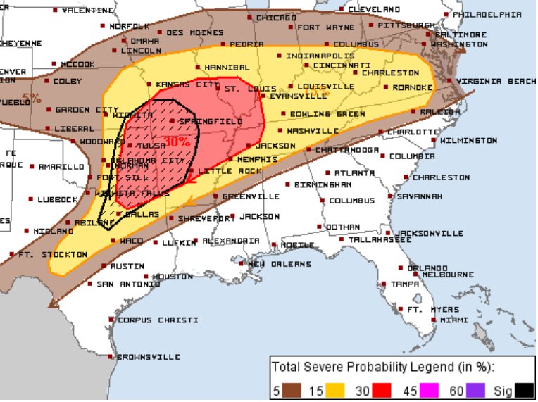
A change in the weather pattern is forecast to take place across the Hill Country and Central Texas regions Sunday, when a weak cold front sags south out of North Texas. The cold front is forecast to reach the northern Hill Country late Sunday morning, with the front sliding down to the Austin area around late Sunday afternoon and the Interstate 10 corridor by about midnight. With abundant moisture and a fairly unstable atmosphere in place, a zone of rain showers and thunderstorms is forecast to develop along the cold front as it moves to the south. Additional rain showers and thunderstorms are forecast behind the cold front Sunday afternoon and Sunday night. There are indications the atmosphere over the region will be sufficiently unstable such that some of the thunderstorms may be strong to severe. The Storm Prediction Center has placed the Hill Country and Central Texas regions under a Slight Risk for severe thunderstorms Sunday into Sunday night. Large hail , damaging downburst winds and dangerous lightning appear to be the primary severe weather threats. The probability for rain will be near 50 percent. Expect a mostly cloudy sky throughout the day. Sunday's temperature is forecast to be near 88-90 degrees.

For the middle Texas coast, Sunday's weather is forecast to be partly cloudy with just a slight chance for a few scattered showers and isolated thunderstorms. Expect a high temperature in the low 90s. The chance for rain will increase to 60 percent Sunday night as the cold front moves into the area.

Rain amounts Sunday through Sunday night are forecast to generally average between 0.5 and 1 inch, with isolated heavier totals.

Weather conditions across the region on Memorial Day are shaping up to be mostly cloudy with a periods of rain showers and thunderstorms. The first in a series of low pressure troughs is forecast to move into Texas out of Mexico, causing the development of rain showers and thunderstorms. The probability for rain will be near 50 percent. Expect a high temperature in the low 80s. Rain amounts Monday are forecast to average around a half inch.

Friday's forecast data indicates additional waves of low pressure will continue to track across Texas out of Mexico all of next week. Additional periods of rain showers and thunderstorms are forecast across the region Tuesday through Friday, with the heaviest rains expected to occur across the Hill Country. The sky is forecast to stay mostly cloudy throughout the week. Daily high temperatures will be in the mid-80s with low temperatures around 68-70 degrees. Rain amounts next week will be highly dependent on how the passing disturbances interact with the Gulf moisture. Significant totals will be possible.

The forecast solutions indicate this cloudy, wet pattern will likely extend into next weekend. There are indications the rain may actually become heavier and more concentrated next weekend when a large trough of low pressure lifts north into Texas out of Mexico. This unsettled pattern is forecast to continue into the first week of June.

I hope everyone has a safe and enjoyable holiday weekend. Stay weather aware and be prepared to seek shelter in a safe place Sunday and Monday should storms and big rains move into your area.

Bob
1 likes   
The preceding post is NOT an official forecast, and should not be used as such. It is only the opinion of the poster and may or may not be backed by sound meteorological data. It is NOT endorsed by any professional institution including storm2k.org. For Official Information please refer to the NHC and NWS products.

User avatar
bubba hotep
S2K Supporter
S2K Supporter
Posts: 5456
Joined: Wed Dec 28, 2016 1:00 am
Location: Collin County Texas

Re: Texas Spring 2017

#1290 Postby bubba hotep » Fri May 26, 2017 1:13 pm

12z Euro hammers DFW with... maybe a trace in some areas this weekend. The cycle is complete.
0 likes   
Winter time post are almost exclusively focused on the DFW area.

Ntxw
Storm2k Moderator
Storm2k Moderator
Posts: 21500
Joined: Wed Oct 21, 2009 6:34 pm
Location: DFW, Texas

Re: Texas Spring 2017

#1291 Postby Ntxw » Fri May 26, 2017 1:25 pm

For the record, today's record high is 99F from 1980 at the airport. Dew point is a little too high to probably break it but we still have till 6pm or so to catch. Tomorrow's is safe at 103 most likely.

CITY SKY/WX TMP DP RH WIND PRES REMARKS
DFW AIRPORT MOSUNNY 94 73 50 S21G26 29.76S HX 103
6HR MIN TEMP: 77; 6HR MAX TEMP: 94;

DALLAS LOVE MOSUNNY 92 71 50 SW12G23 29.78S HX 98
6HR MIN TEMP: 77; 6HR MAX TEMP: 92;

FTW MEACHAM MOSUNNY 96 74 48 S21 29.76F HX 107
6HR MIN TEMP: 75; 6HR MAX TEMP: 96;

DAL-EXECUTIVE MOSUNNY 90 74 59 S10G21 29.79S HX 99
6HR MIN TEMP: 76; 6HR MAX TEMP: 91;

FTW-ALLIANCE MOSUNNY 94 73 50 SW16G28 29.76S HX 103
6HR MIN TEMP: 74; 6HR MAX TEMP: 94;

FTW-NAS-JRB PTSUNNY 94 73 50 SW15G24 29.77S HX 103
6HR MIN TEMP: 75; 6HR MAX TEMP: 94;

FTW-SPINKS MOSUNNY 91 72 52 S16G25 29.80S HX 98
ARLINGTON MOSUNNY 89 72 56 S18G25 29.78S HX 96
6HR MIN TEMP: 75; 6HR MAX TEMP: 90;

GRAND PRAIRIE SUNNY 90 70 51 S14 29.80R HX 95
ADDISON MOSUNNY 90 72 55 S17G30 29.78S HX 96
MESQUITE MOSUNNY 88 70 55 S21G28 29.80S HX 92
LANCASTER MOSUNNY 89 72 56 S18G28 29.81S HX 96
0 likes   
The above post and any post by Ntxw is NOT an official forecast and should not be used as such. It is just the opinion of the poster and may or may not be backed by sound meteorological data. It is NOT endorsed by any professional institution including Storm2k. For official information, please refer to NWS products.


  Help support Storm2K!

Help Support Storm2K


User avatar
GalvestonWXGeek
Tropical Low
Tropical Low
Posts: 29
Joined: Mon Jul 25, 2016 1:16 pm
Location: Galveston, Texas

Re: Texas Spring 2017

#1292 Postby GalvestonWXGeek » Fri May 26, 2017 1:44 pm

Texas Snowman wrote:@BigJoeBastardi: only place near US favored in phase 4/5 MJO is extreme nw gulf, where euro hints at mischief day 8-10


Yuck.
0 likes   
I am not a professional meteorologist. Please do NOT consider any of my comments to be a "forecast".

User avatar
srainhoutx
S2K Supporter
S2K Supporter
Posts: 6919
Age: 66
Joined: Sun Jan 14, 2007 11:34 am
Location: Haywood County, NC
Contact:

Re: Texas Spring 2017

#1293 Postby srainhoutx » Fri May 26, 2017 2:11 pm

bubba hotep wrote:
Ntxw wrote:
bubba hotep wrote:I know the Euro scores the highest in 500mb anomaly verification but it has been a clown show when it comes to precipitation placement beyond 3 days. It has constantly shown heavy rain events for DFW all spring in the 4 - 10 day range only to dry them up right at the very end. Once again, what looked like a solid rain event for the DFW area this weekend has now dried up.


It has been pretty bad, for the GFS at times too. Generally go with the model that shows the lowest qpf and you will probably be right.


That has certainly been the theme the past couple of months. With that said, some of the CAMs are pretty aggressive tomorrow:

 https://twitter.com/whatisthisrds/status/868107322392014849


The TT 3km WRF did rather well with the extreme micro burst super cell in Austin County earlier this week within 24 hours, for what it's worth.
1 likes   
Carla/Alicia/Jerry(In The Eye)/Michelle/Charley/Ivan/Dennis/Katrina/Rita/Wilma/Ike/Harvey

Member: National Weather Association
Wx Infinity Forums
http://wxinfinity.com/index.php

Facebook.com/WeatherInfinity
Twitter @WeatherInfinity

User avatar
Texas Snowman
Storm2k Moderator
Storm2k Moderator
Posts: 6011
Joined: Fri Jan 25, 2008 11:29 am
Location: Denison, Texas

Re: Texas Spring 2017

#1294 Postby Texas Snowman » Fri May 26, 2017 2:55 pm

20th anniversary of the killer F5 Jarrell, Texas tornado is tomorrow:

http://www.weather.gov/ewx/JarrellTornadoAnniversary

https://www.youtube.com/watch?v=PhjFiiff69o&sns=em
1 likes   
The above post and any post by Texas Snowman is NOT an official forecast and should not be used as such. It is just the opinion of the poster and may or may not be backed by sound meteorological data. It is NOT endorsed by any professional institution including storm2k.org. For official information, please refer to NWS products.

Ntxw
Storm2k Moderator
Storm2k Moderator
Posts: 21500
Joined: Wed Oct 21, 2009 6:34 pm
Location: DFW, Texas

Re: Texas Spring 2017

#1295 Postby Ntxw » Fri May 26, 2017 4:05 pm

First of the season. 95F at DFW and heat index at 106, starting early this year. 101F in San Angelo seems to be the state max at the moment and around 80 is the coolest at Dumas in the Panhandle.

URGENT - WEATHER MESSAGE
National Weather Service Fort Worth TX
335 PM CDT Fri May 26 2017

.Hot and humid conditions will result in dangerous heat across
portions of North Texas on Saturday Afternoon...

TXZ091-092-101>103-116>119-131>133-270500-
/O.NEW.KFWD.HT.Y.0001.170527T1900Z-170528T0000Z/
Montague-Cooke-Jack-Wise-Denton-Palo Pinto-Parker-Tarrant-Dallas-
Hood-Somervell-Johnson-
Including the cities of Bowie, Nocona, Gainesville, Jacksboro,
Decatur, Bridgeport, Carrollton, Denton, Lewisville,
Flower Mound, Mineral Wells, Weatherford, Briar, Fort Worth,
Arlington, Dallas, Granbury, Oak Trail Shores, Glen Rose,
Cleburne, and Burleson
335 PM CDT Fri May 26 2017

...HEAT ADVISORY IN EFFECT FROM 2 PM TO 7 PM CDT SATURDAY...

The National Weather Service in Fort Worth has issued a Heat
Advisory, which is in effect from 2 PM to 7 PM CDT Saturday.

* TEMPERATURES...Max temperatures will climb into the mid 90s
with heat index values in the 103 to 107 degree range.
0 likes   
The above post and any post by Ntxw is NOT an official forecast and should not be used as such. It is just the opinion of the poster and may or may not be backed by sound meteorological data. It is NOT endorsed by any professional institution including Storm2k. For official information, please refer to NWS products.


  Help support Storm2K!

Help Support Storm2K


Brent
S2K Supporter
S2K Supporter
Posts: 37089
Age: 35
Joined: Sun May 16, 2004 10:30 pm
Location: Tulsa Oklahoma
Contact:

Re: Texas Spring 2017

#1296 Postby Brent » Fri May 26, 2017 4:09 pm

It's gonna be a long summer
1 likes   
#neversummer

Ntxw
Storm2k Moderator
Storm2k Moderator
Posts: 21500
Joined: Wed Oct 21, 2009 6:34 pm
Location: DFW, Texas

Re: Texas Spring 2017

#1297 Postby Ntxw » Fri May 26, 2017 4:10 pm

Brent wrote:It's gonna be a long summer


I had to make a drop in the airport and on my way much of median and grassy areas are browning/yellowing much more than the past 2 seasons that I have noticed. East of 35 isn't as bad on the way to work but west of 35 it's noticeable.
0 likes   
The above post and any post by Ntxw is NOT an official forecast and should not be used as such. It is just the opinion of the poster and may or may not be backed by sound meteorological data. It is NOT endorsed by any professional institution including Storm2k. For official information, please refer to NWS products.


  Help support Storm2K!

Help Support Storm2K


User avatar
bubba hotep
S2K Supporter
S2K Supporter
Posts: 5456
Joined: Wed Dec 28, 2016 1:00 am
Location: Collin County Texas

Re: Texas Spring 2017

#1298 Postby bubba hotep » Fri May 26, 2017 7:25 pm

18z Texas Tech

Image
0 likes   
Winter time post are almost exclusively focused on the DFW area.

Yukon Cornelius
S2K Supporter
S2K Supporter
Posts: 1737
Age: 40
Joined: Thu Dec 20, 2012 9:23 pm
Location: Dean, TX/Westcliffe, CO

Re: Texas Spring 2017

#1299 Postby Yukon Cornelius » Fri May 26, 2017 7:46 pm

Ntxw wrote:
Brent wrote:It's gonna be a long summer


I had to make a drop in the airport and on my way much of median and grassy areas are browning/yellowing much more than the past 2 seasons that I have noticed. East of 35 isn't as bad on the way to work but west of 35 it's noticeable.

Go even further west and it's getting really bad. I've been spoiled the last couple of years I guess, with lush pastures and nice green grass everywhere. It's getting pretty sparse around here lately and the 3-4" of rain recently didn't really seem to help at all. Like Brent said, "Its gonna be a long summer".
0 likes   
#neversummer

Brent
S2K Supporter
S2K Supporter
Posts: 37089
Age: 35
Joined: Sun May 16, 2004 10:30 pm
Location: Tulsa Oklahoma
Contact:

Re: Texas Spring 2017

#1300 Postby Brent » Fri May 26, 2017 11:03 pm

the NAM has an MCS/line moving from Oklahoma into DFW and east in the predawn hours Sunday.
0 likes   
#neversummer


Return to “USA & Caribbean Weather”

Who is online

Users browsing this forum: No registered users and 73 guests